- M-27 (Michigan highway)
-
This article describes a Michigan state trunkline highway numbered M-27. For the former U.S. Highway, see U.S. Route 27 in Michigan; for other uses, see M27 (disambiguation)
M-27
M-27 highlighted in redRoute information Maintained by MDOT Length: 16.763 mi[3] (26.977 km) Existed: Late 1961[1][2] – present Major junctions South end:  I-75 near Indian River
 M-33 near Aloha
North end: 
 US 23 / C-66 in Cheboygan
Location Counties: Cheboygan Highway system Michigan State Trunkline Highway System
Interstate • US • State←  US 27
US 27M-28  →
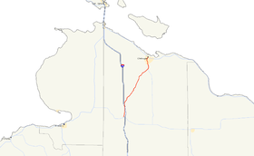
→M-27 is a north–south state trunkline highway in the extreme north of the Lower Peninsula of the US state of Michigan. The route runs between Interstate 75 (I-75) just north of Indian River and Cheboygan, where it meets US Highway 23 (US 23) near Lake Huron. It remains as a relic of the old US 27 which disappeared north of Grayling after being supplanted by I-75, which lies close to old US 27 between Grayling and Indian River.
Contents
Route description
I-75 takes a more direct route between Indian River and Mackinaw City. M-27 follows old US 27 through Topinabee and Cheboygan. With US 23 it is a scenic, if indirect, alternative to I-75 on its approach to the Mackinac Bridge. M-27 runs along the western shore of Mullett Lake and forms the main street of Topinabee. The highway intersects M-33 near the confluence of the Cheboygan and Black rivers. North of the M-33 junction, M-27 runs parallel to the Cheboygan River on the west river bank into downtown Cheboygan.[4][5]
M-27 has the local road name of "Main Street" in Cheboygan and "Straits Highway" outside the of the city. State Street (US 23) and Main Street (M-27) form the two major streets in the Cheboygan street grid. The main downtown businesses are located along Main Street south to the city limits.[5] The highway has not been listed on the National Highway System,[6] a network of roads important to the country's defense, economy and mobility.[7]
History
Previous alignment
This is the second time a highway was designated M-27 in Michigan. The original M-27 was located in The Thumb, running from the Mount Clemens area east and north through New Baltimore to Port Huron. There it ran through Carsonville and Minden City to Harbor Beach and along Lake Huron to Port Austin. This version of M-27 was designated by July 1, 1919,[8] and would last until 1926. All of the original M-27 was given to other contemporary highways including M-29 (Mount Clemens to Port Huron), M-51 (Port Huron to M-83), and M-29 (Harbor Beach to Port Austin).[9]
Current alignment
In the late 1950s, US 27 was the main highway connection between Grayling, Gaylord, and Cheboygan.[10] After the construction of the Mackinac Bridge, US 27 was extended north to St. Ignace.[11] The construction of I-75 in the early 1960s obsoleted the northern portion of US 27. Between Grayling and Indian River, I-75 replaced US 27 as the main highway in the area. North of Indian River, I-75 was built along a different routing. Where US 27 ran northwest through Topinabee to Cheboygan and then concurrently along US 23 to Mackinaw City, I-75 was built due north of Indian River before turning northwest parallel and several miles inland from Lake Huron, bypassing Cheboygan completely.[1] M-27 was designated in the latter half of 1961 on the current alignment replacing US 27 which was truncated back to Grayling.[1][2] Today, the streach from Grayling to about Wolverine is known as Old 27, and from there to Indian River, it is called Straits Highway.[5]
Major intersections
The entire highway is in Cheboygan County.
Location Mile[3] Destinations Notes Mullett Township 0.000 I-75 – Gaylord, Mackinac BridgeExit 313 on I-75 Inverness Township 13.309 M-33 south – OnawayNorthern terminus of M-33 14.130  C-64 west (VFW Road)
Cheboygan 16.763 US 23 – Mackinaw City, Rogers City
C-66 west (State Street to Levering Road)C-66 approaches from the west and terminates;
US 23 continues through to the east or north1.000 mi = 1.609 km; 1.000 km = 0.621 mi References
- ^ a b c Michigan State Highway Department (1961). Official Highway Map (Map). Section E11–G10. (Includes all changes through July 1, 1961)
- ^ a b Michigan State Highway Department (1962). Official Highway Map (Map). Section E11–G10.
- ^ a b "MDOT Physical Reference Finder Application". Michigan Department of Transportation. 2009. http://www.mcgi.state.mi.us/prfinder/. Retrieved April 9, 2010.
- ^ Michigan Department of Transportation (2010). Official Department of Transportation Map (Map). 1 in:15 mi/1 cm:9 km. Section E11.
- ^ a b c Google, Inc. Google Maps – Overview Map of M-27 (Map). Cartography by Google, Inc. http://maps.google.com/maps?f=d&source=s_d&saddr=M-27+N&daddr=S+Main+St&hl=en&geocode=FQuMtQIdnvP0-g%3BFbODuAId9QP3-g&mra=ls&sll=45.642128,-84.477868&sspn=0.028053,0.029097&ie=UTF8&t=h&z=12. Retrieved January 26, 2008.
- ^ Michigan Department of Transportation (April 23, 2006) (PDF). National Highway System, Michigan (Map). http://www.michigan.gov/documents/MDOT_NHS_Statewide_150626_7.pdf. Retrieved October 7, 2008.
- ^ "The National Highway System". Federal Highway Administration. August 26, 2010. http://www.fhwa.dot.gov/planning/nhs/. Retrieved January 1, 2011.
- ^ Michigan State Highway Department (July 1, 1919). State of Michigan: Lower Peninsula (Map). Cartography by MSHD.
- ^ Michigan State Highway Department (December 1, 1926). Official Highway Service Map (Map). Cartography by MSHD.
- ^ Michigan State Highway Department (October 1, 1957). 1957 Official Highway Map (Map). Section E11–G10.
- ^ Michigan State Highway Department (1958). Official Highway Map (Map). Section E10. (Includes all changes through July 1, 1958)
External links
Categories:- State highways in Michigan


Wikimedia Foundation. 2010.