- M-51 (Michigan highway)
-
M-51
Route information Maintained by MDOT Length: 40.33 mi[1] (64.90 km) Existed: 1971 – present Major junctions South end:  SR 933 near South Bend, Indiana
 US 12 near Niles
 M-62 near Dowagiac
 M-152 near Dowagiac
North end:  I-94 / CR 671 near Paw Paw
Location Counties: Berrien, Cass, Van Buren Highway system Michigan State Trunkline Highway System
Interstate • US • State←  M-50
M-50M-52  →
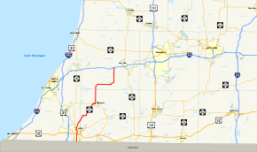
→M-51, is a north–south state trunkline highway in the southwestern portion of the US state of Michigan. The northern terminus is on I-94 west of Paw Paw, where it continues north for less than a mile to W Red Arrow Highway as Van Buren CR 671, and the southern terminus is at the Indiana state line between Niles and South Bend, Indiana, where it continues as State Road 933. The total length is 40.33 miles (64.90 km).
Contents
Route description
M-51 starts at the state line as a continuation of SR 933 into Michigan. The trunkline runs north to Niles. From Niles, it angles northeast toward Dowagiac where it then runs north before bending to run almost due east toward Decatur, after which is heads due north to I-94.
M-51 is in fact a designation of what used to be two different highways. Until the 1960s the route north of Niles was known as M-40 until M-40 was diverted to its current route south of Paw Paw. Until the 1990s, the segment between Niles and the Indiana state line was known as US 33 before US 33 was deleted northwest of Elkhart, Indiana. Earlier, it had also been designated as US 31 before the St. Joseph Valley Parkway was built west of Niles. The segment of old US 31 and US 33 in Michigan south of Niles became M-51 in April 1998.[2]
History
M-51 was originally designated from Port Huron to M-83 (now M-142) west of Harbor Beach. The designation of M-51 from Port Huron to M-46 (Carsonville) was removed, and the remainder of it to M-142 was removed in the mid 1960s.
In early 2010, the central section of BUS US 12 was transferred to the City of Niles. In doing so, the BUS US 12 designation was decommissioned in the city, removing that designation from the M-51 concurrency.[3]
Major intersections
County Location Mile Destinations Notes Berrien Bertrand Township 0.00 SR 933 – South BendIndiana state line US 12 – Detroit, ChicagoNiles 
 BUS M-60 east
Eastern terminus of BUS M-60 Cass Dowagiac M-62 northWestern end of M-62 concurrency M-62 southEastern end of M-62 concurrency Silver Creek Township –
Wayne Township M-152 westEastern terminus of M-152 Van Buren Paw Paw Township 40.33 I-94 – Detroit, ChicagoExit 56 on I-94 1.000 mi = 1.609 km; 1.000 km = 0.621 mi
Concurrency terminus • Closed/Former • Incomplete access • UnopenedReferences
- ^ Michigan Highways: Highways 50 through 59 Christopher J. Bessert. URL accessed Sep 8 2006.
- ^ "Portion of U.S. 33 is now Indiana 933". South Bend Tribune. April 18, 1998. http://pqasb.pqarchiver.com/southbendtribune/access/36119474.html?FMT=ABS. Retrieved December 29, 2008.
- ^ Contract Number 2010-0086 Effective date of transfer: March 5, 2010, Roadway segment Transferred from MDOT to the City of Niles, becoming a City Major street: US-12 Business Route (BR)/Main Street, from the centerline of Old US-31/Front Street easterly to the centerline of M-51/North Fifth Street, a distance of approximately 0.24 miles, in control section 11041.
External links
Categories:- State highways in Michigan
- Dixie Highway


Wikimedia Foundation. 2010.