- M-50 (Michigan highway)
-
This article is about the state highway in Michigan; for other uses, see M50 (disambiguation)
M-50
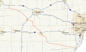
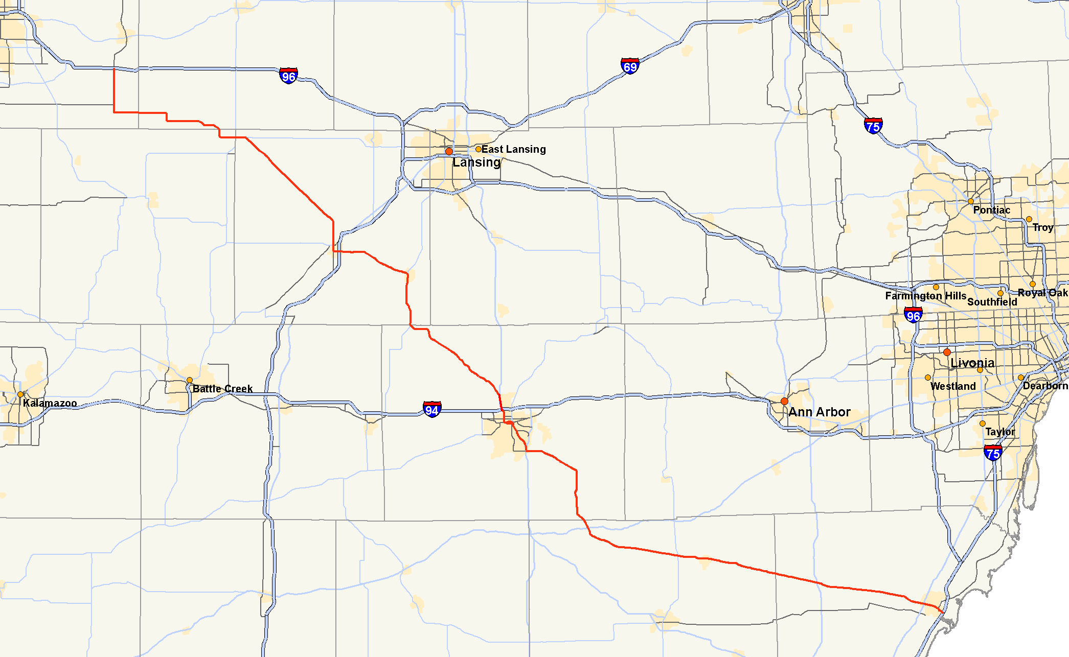
M-50 highlighted in redRoute information Maintained by MDOT Length: 140.22 mi[2] (225.66 km) Existed: 1926[1] – present Major junctions West end:  I-96 near Alto
 M-43 / M-66 at Woodbury

 I-69 / M-79 at Charlotte

 I-94 / US 127 at Jackson
 M-106 in Jackson
 US 12 near Brooklyn
 M-52 near Tecumseh
 US 23 at Dundee
East end:  US 24 in Monroe[1][3]
Location Counties: Kent, Ionia, Barry, Eaton, Jackson, Lenawee, Monroe Highway system Michigan State Trunkline Highway System
Interstate • US • State←  M-49
M-49M-51  →
→M-50 is a state trunkline highway in the US state of Michigan. Although designated as an east–west highway, it is nearly a diagonal northwest-southeast route. It has its western terminus near Alto a few miles/kilometers east of the metro Grand Rapids area and its eastern terminus in downtown Monroe now at Telegraph Road as of October 1, 2006.[1]
Contents
Route description
I-96 to I-69
M-50 begins at an interchange with I-96 at exit 52 just south of Lowell in southeastern Kent County. The route then proceeds south before turning east on 92nd Street where it crosses into Ionia County and continues on into Lake Odessa. In Lake Odessa, the road bends around the north side of Jordan Lake, curving to the south and then back east as it heads towards a junction with M-66 and M-43.
Upon meeting up with M-43, the two routes run concurrently for about a mile before M-50 breaks off to the southwest just east of Woodbury. From there, the road continues its southeast path, as the Clinton Trail, through the northeast part of Eaton County as it descends into Charlotte. Just prior to entering the city, the road bends to the south and near the middle of town it has a junction with M-79. After M-79, the road continues south for a several blocks before turning east where it has an interchange with I-69 at exit 60.
I-69 to I-94
After heading east past the junction with I-69, the road turns southeast as it heads through rural fields towards Eaton Rapids. Upon reaching the city, the road converges with M-99 and junction with M-188 on the south side of the Grand River. The two highways run south out of the city and immediately prior to entering Jackson County the two roads diverge with M-99 heading off to the southwest and M-50 to the southeast.
M-50 continues its journey through Jackson County, winding its way to the southeast through rural fields and small forests. The residential buildup begins as the road approaches the US 127 freeway north of Jackson. Upon reaching Blackman Township, M-50 merges with US 127 to run concurrently into the north side of Jackson. After having an interchange with I-94 at exit 138, where US 127 exits to run east on I-94 for 4 miles (6.4 km), M-50 and Business US 127 (BUS US 127) run concurrently into the city as West Avenue passing by the Jackson Crossing shopping mall. The road then proceeds south through the northern side of the city before turning east on Michigan Avenue as it heads towards downtown.
I-94 to M-52
In downtown Jackson, Michigan Avenue continues into downtown while M-50 is routed around the city center along paired one way streets. Washington Street carries eastbound traffic and the Louis Glick Highway. On the east side of downtown, the roads merge near the Jackson Amtrak station on Cooper Street, where M-50 turns south and then southeast as Brooklyn Road. On the south side of Jackson, M-50 and US 127 meet up once again just east of Vandercook Lake, and heads east away from Vandercook Lake.
The route then heads southeast to Napoleon, where the road then turns south and heads towards Brooklyn, part of the Irish Hills area of Lenawee County, a region known for scenery. The road serves as main street for downtown Brooklyn as well as the primary thoroughfare for drivers headed to Michigan International Speedway. M-50 curves around the north and east side of the race track before having a junction with US 12 just southeast of Brooklyn. After crossing US 12, the road passes between several lakes of the Irish Hills area including Washington, Little Stony and Marrs Lakes before continuing on its southeast journey towards Tecumseh.
After leaving the Brooklyn area, the road returns to its rural experience as it cuts through agricultural fields. Just before passing through Tipton, the road passes by the entrance to Hidden Lake Gardens, a botanical garden and arboretum operated by Michigan State University. Soon after passing Hidden Lake, the road junctions with M-52 and continues into Tecumseh. Known as Chicago Boulevard, the road serves as the main route through the city. After leaving the city, the road quickly passes through the communities of Ridgeway and Britton before leaving Lenawee County.
M-52 to US 24
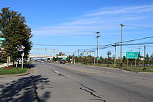 Intersection of M-50 and US 23, Dundee, on M-50 facing west
M-50 begins the final leg of its journey, as it crosses into Monroe county, passing through mostly fields. Just prior to reaching its interchange with US 23, the highway passes just to the south of Cabela's, a 225,000-square-foot (20,900 m2) outdoor sports retailer in Dundee. As of 2007 it is the 3rd largest of 32 stores of its kind in the United States. After leaving Dundee, the road continues to the southeast, running to the south of the Raisin River, through rural areas as South Custer Road before entering the outskirts of Monroe where it finally ends its journey at a junction with US 24, known locally as Telegraph Road.
Past US 24, the road continues as Front Street to a junction with I-75 at exit 13. This is a former part of M-50 that was eliminated first in 1996 when it was scaled back to end at M-125 in downtown Monroe and again in 2006 when it was finally scaled back to its present ending with US 24.[4][5]
History
In the pre-Interstate era, M-50 served as most of the Grand-Rapids-Jackson route for those who sought to avoid greater Lansing. Except for segments in which it coincides with US 127 it is all undivided surface road. When M-50 was first commissioned into the highway system in 1920, it started at a junction with M-23 in Cambridge, just south of Brooklyn which is present day US 12. From there it ran to the southeast, similar to its present day routing, through Dundee and Tecumseh to M-65 (later US 23) where it then turned north to Grape then southeast into downtown Monroe. In 1925, the western end of M-50 is extended north through Brooklyn and Napoleon to a new terminus in Jackson.
In 1928, M-50 undergoes a major lengthening as its western terminus is extended from Jackson to Eaton Rapids, Charlotte and Vermontville before intersecting M-39 just east of Woodbury. From this point, M-50 is routed over M-39 to US 16 near Alto. M-50 then runs concurrently with US 16 into Grand Rapids where it turned to the west and traveled through Allendale before heading northwest and terminating in Grand Haven at a junction with US 31. A few years later, the western end of the route is realigned to run out of Grand Rapids to Agnew, terminating at US 31 eight miles (13 km) south of its previous end.
In 1951, when the US 12 bypass is constructed, US 127 and M-50 are routed onto it on the north side of Jackson. In 1953, the route is realigned onto the south and west beltline to bypass Grand Rapids. The old routing through Grand Rapids becomes Business M-50. The M-50 assignment is also removed from the US 12 bypass of Jackson west of US&hnbsp;127 once it was finished.
In 1959, when the US 127 freeway bypass east of Jackson opens up, and the old routing through town becomes BUS US 127 and BUS M-50. The concurrency with US 23 between Dundee and the Ohio border is dropped after the new US 23 freeway is opened, the old route becomes designated, solely, M-50. In 1961, when the I-96/US 16/M-50 freeway is extended to the northwest in Grand Rapids, the old M-50 routing through the city becomes M-11.
In 1964, the western end of M-50 gets truncated from its junction with US 31 back to I-96 south of Lowell at exit 52. The decommissioned alignment from exit 40 to Agnew is then given the M-45 designation. In 1966, the eastern end of M-50 is extended to take over the remaining portion of M-56 shifting the terminus to the southeast to end at an interchange with I-75 at exit 15. Thirty years later, this extension would get truncated as the terminus is scaled back to M-125 in Monroe. Finally in 2006, the section of M-50 between M-125 and US 24 is also removed, shortening the highway by about a mile.[1]
Major intersections
County Location Mile[2][6] Destinations Notes Kent Lowell Township 0.00 I-96 – Grand Rapids, LansingExit 52 on I-96 Barry Woodland Township 22.64 M-43 west
M-66Western end of M-43 concurrency Eaton Sunfield Township 23.94 M-43 eastEastern end of M-43 concurrency Charlotte 41.86 M-79 west43.33 I-69 – Lansing, Ft. WayneExit 60 on I-69 Eaton Rapids 52.44  M-99 north
Northern end of M-99 concurrency 52.94  M-188 east
Hamlin Township 58.86 M-99 southSouthern end of M-99 concurrency Jackson Blackman Township 74.33 US 127 northWestern end of US 127 concurrency at exit 46 on US 127 75.54 I-94 south / US 127


BUS US 127 southSouthern end of US 127 concurrency and northern end of the BUS US 127 concurrency; exit 138 on I-94 and exit 43 on US 127 Jackson 78.51 M-106Summit Township 81.84 US 127
BUS US 127 northExit 34 on US 127; southern end of the BUS US 127 concurrency Brooklyn 93.61  M-124
M-124Lenawee Cambridge Township 96.89 US 12Franklin Township 108.99 M-52Monroe Dundee 126.57 US 23 – Ann Arbor, ToledoExit 17 on US 23 Monroe 140.22 US 241.000 mi = 1.609 km; 1.000 km = 0.621 mi
Concurrency terminus • Closed/Former • Incomplete access • UnopenedSee also
References
- ^ a b c d Michigan Highways: Highways 50 through 59 Christopher J. Bessert, URL accessed Sep 7 2006
- ^ a b "MiGDL - Center for Geographic Information - Geographic Data Library". Michigan Department of Information Technology. May 2007. http://www.mcgi.state.mi.us/mgdl/?rel=thext&action=thmname&cid=14&cat=MI+Geographic+Framework+All+Roads+%28v7b%29. Retrieved February 24, 2008.
- ^ Patrick Allen (October 5, 2006). "M-50 jurisdictional transfer". Lakes Roads Great Lakes Roads. (Web link). Retrieved February 25, 2008.
- ^ "Google Maps". Google Maps. http://maps.google.com/. Retrieved February 24, 2008.
- ^ Michigan Department of Transportation. Official 2007 Department of Transportation Map (Map) (2007 ed.).
- ^ "Control Section/Physical Reference Atlas". Michigan Department of Transportation. 2001. http://mdotwas1.mdot.state.mi.us/public/maps/pr/. Retrieved February 24, 2008.
External links
Categories:- State highways in Michigan
- Central Michigan


Wikimedia Foundation. 2010.