- M-99 (Michigan highway)
-
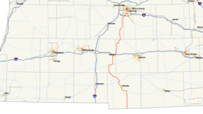
M-99
Route information Maintained by MDOT Length: 86.19 mi[1] (138.71 km) Existed: 1939 – present Major junctions South end:  SR 15 near Pioneer, Ohio
 M-34 near Osseo
 US 12 in Jonesville
 M-49 in Litchfield
 M-60 in Homer
 I-94 near Albion
 M-50 in Eaton Rapids
 I-96 in Lansing
North end:  I-496 near Lansing
Location Counties: Hillsdale, Calhoun, Jackson, Eaton, Ingham Highway system Michigan State Trunkline Highway System
Interstate • US • State←  M-98
M-98M-100  →
→←  M-8
M-8
US 10  →
→←  M-157
M-157
M-160  →
→M-99 is a state highway in the Lower Peninsula of the US state of Michigan. It runs from the Ohio state border, where it connects to SR 15, north to Lansing where it terminates at a junction with I-496. It mainly serves local communities along the route as the I-69 corridor is nearby to the west, while the US 127 corridor is close to the east.
Contents
Route description
Ohio State Route 15 crosses into Michigan just north of Pioneer, Ohio where it becomes M-99. It then travels north, through mostly agricultural areas before reaching a junction with M-34 just west of Osseo. The route then travels westward, bending to the north around Baw Beese Lake just southeast of Hillsdale. M-99 passes through Hillsdale on a northwest course, passing just a few blocks to the west of Hillsdale College. After leaving Hillsdale, the road bends to the north as it heads to Jonesville where it junctions with US 12. The two routes share a concurrency in Jonesville that is less than half a mile before M-99 returns to its northwesterly course as it leaves the town towards Litchfield.
In Litchfield, M-99 enters the town from the southwest, passing near the center of town where it meets the northern terminus of M-49. The route then leaves Litchfield heading northwest for a few miles before bending to the north as it heads towards Homer. In Homer, after passing through a roundabout, M-99 meets up with M-60 and, together, leave the town to the northeast. The road briefly becomes divided to provide an enhanced junction to end the concurrency as M-99 heads north, while M-60 continues east. From here, the route continues northward towards the city of Albion. After crossing the Kalamazoo River in downtown Albion, M-99 junctions with the I-94 business loop. The business loop has a junction with M-199 just a few blocks north of the intersection. M-99 continues east concurrently with the business loop passing by Albion College before heading back north to an interchange with I-94 at exit 124.
M-99 continues north to the village of Springport where it briefly becomes Main Street as it passes through the town before continuing north east on Eaton Rapids Road. Shortly after leaving Springport, M-50 comes in from the southwest to meet up with M-99 where the two travel together into Eaton Rapids. Together they form Main Street in Eaton Rapids before they split ways on the north side of town where M-50 leaves to the northwest as Dexter Road (Clinton Trail outside of the city limits) and M-99 continues to the northeast as first Canal Street, and then Michigan Street. For the next few miles, the road parallels the general course of the Grand River before crossing over the river just southeast of Diamondale where it then has an interchange with I-96 at exit 101.
From I-96, the road continues north into the outskirts of Lansing as Martin Luther King Jr. Boulevard. The road then travels north through the southern side of the Capitol City, crossing major city thoroughfares such as Jolly Road and Mount Hope Avenue before ending at a junction with I-496 at exits 5 and 6.
History
In the 1920s, M-99 was designated on a road between the Lake Michigan shoreline and M-11 (now US 31) between Muskegon and Hart; in the 1930s, M-99 was designated on a gravel road in the Upper Peninsula from US 2 (just east of Gulliver) to Port Inland on Lake Michigan.
The current incarnation of M-99 was originally M-9 until 1939 when the designation was removed in an effort to retain single digit designations for planned "super highways" in Michigan which never came to fruition.[1] In 1934, M-9 traveled on Pioneer Road, in Hillsdale County, from the Ohio border before turning west on Burt Road, north on Clark Road, west on Montgomery Road then north onto Hillsdale Road. During this time a loop was planned to continue north from the corner of Pioneer and Burt Roads to Montgomery Road where it turned west and met back up with M-9 at Clark Road. This short loop was designated M-158, however later in the year the routing of M-9 was shifted onto the M-158 alignment thereby ending its short tenure in the state highway system. The M-158 designation has not been used since.[2]
Major intersections
County Location Mile[3] Destinations Notes Hillsdale Amboy Township 0.00 SR 15Ohio state line Osseo 12.63 M-34Jonesville 22.90 US 12 westSouthern end of US 12 concurrency 23.24 US 12 eastNorthern end of US 12 concurrency Litchfield 30.18 M-49Calhoun Homer 38.36 M-60 westWestern end of M-60 concurrency Albion Township 41.57 M-60 eastEastern end of M-69 concurrency Jackson Parma Township 50.45 I-94Exit 124 on I-94 Eaton Springport Township 63.42 M-50 westSouthern end of M-50 concurrency Eaton Rapids 69.31  M-188
M-18869.81 M-50 westNorthern end of M-50 concurrency Ingham Lansing 81.40 I-9686.19 I-496
 Capitol Loop east
Northern terminus of M-99 and western terminus of the Capitol Loop; exits 5 & 6 on I-496 1.000 mi = 1.609 km; 1.000 km = 0.621 mi
Concurrency terminus • Closed/Former • Incomplete access • UnopenedReferences
- ^ a b Michigan Highways: Highways 90 through 99 Christopher J. Bessert. URL accessed September 1, 2006.
- ^ Bessert, Christopher J.. "Michigan Highways: Master List 1918-Present". Michigan Highways. http://www.michiganhighways.org/master_list.html#routes140-159. Retrieved March 7, 2008.
- ^ "MiGDL - Center for Geographic Information - Geographic Data Library". Michigan Department of Information Technology. May 2007. http://www.mcgi.state.mi.us/mgdl/?rel=thext&action=thmname&cid=14&cat=MI+Geographic+Framework+All+Roads+%28v7b%29. Retrieved February 9, 2008.
External links
Categories:- State highways in Michigan
- Transportation in Lansing, Michigan
- Central Michigan


Wikimedia Foundation. 2010.