- Interstate 94 in Michigan
-
This article is about the section of highway in Michigan. For the entire length of highway, see Interstate 94.
Interstate 94
Edsel Ford Freeway 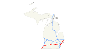
I-94 highlighted in redRoute information Maintained by MDOT Length: 275.39 mi[1] (443.20 km) Existed: ca. 1958[1] – present Tourist
routes:Lake Michigan Circle Tour Major junctions West end:  I-94 near New Buffalo
 I-196 / US 31 in Benton Harbor
 US 131 in Portage
 I-194 in Battle Creek
 I-69 near Marshall
 US 127 in Jackson
 US 23 in Ann Arbor
 I-96 in Detroit
 I-75 in Detroit
 I-696 in St. Clair Shores I-69 in Port Huron
East end:  Highway 402 at Canadian border on Blue Water Bridge in Port Huron
Highway system Main route of the Interstate Highway System
Main • Auxiliary • BusinessMichigan State Trunkline Highway System
Interstate • US • State←  M-93
M-93M-94  →
→
Interstate 94 (I-94) is a part of the Interstate Highway System that runs from Billings, Montana, to the Lower Peninsula of the US state of Michigan. In Michigan, it is a state trunkline highway that enters the state south of New Buffalo. It runs east to Detroit before terminating on the Blue Water Bridge at the US–Canadian border.
Contents
Route description
I-94 enters Michigan and parallels Lake Michigan up to St. Joseph before turning east. It then passes Kalamazoo, Battle Creek, Jackson and Ann Arbor before entering Detroit. It exits Detroit to the northeast, meets I-69 at Port Huron. Both routes end on Blue Water Bridge at Ontario Highway 402.
Lane configurations
- Between Interstate 196 and Indiana state line (3 lanes on each side — a 4th lane was added westbound in 2006 between Exit 30 and Exit 29[2]
- Between just west of Exit 74 (US 131) and Exit 34 (Interstate 196) (2 lanes on each side)
- Between Exit 76 and just west of Exit 74 (US-131)(will extend to exit 78 when project is completed in 2011) (3 lanes on each side)
- Between just west of Exit 167 (Baker Rd.) and Exit 76 (2 lanes on each side)
- Between Exit 171 (M-14) and just west of Exit 167 (Baker Rd.) (3 lanes on each side)
- Between Exit 180 (US 23) and Exit 171 (M-14) (2 lanes on each side)
- Between Exit 198 (Detroit Metropolitan Airport) and Exit 180 (US-23) (3 lanes on each side)
- For Exits 199 (Detroit Metropolitan Airport/Middle Belt Road) and 198 (Merriman Road) (2 Local + 3 Express Lanes each side)
- Between Exit 243 (23 Mile Rd.) and Exit 198 (3-4 lanes on each side)
- Between Blue Water Bridge and Exit 243 (23 Mile Rd.) in Chesterfield Township, MI (2 lanes on each side)
History
Pre designation
In early plans for the Interstate Highway System, I-94 between Benton Harbor and Detroit was proposed to be numbered I-92. The originally proposed route for I-94 became the pre-1963 routing for I-96.[3]
Through much of Michigan Interstate 94 follows the route of old U.S. 12; to the west of Detroit it uses the pre-existing Detroit Industrial Expressway which had been built during World War II to accommodate transportation of workers and in Detroit it follows the route of the Edsel Ford Freeway.[4] Signage for the Edsel Ford Freeway remained in place until the late 1980s when Michigan deemphasized proper names on Interstate guide signs.
Land acquisition for the Edsel Ford Freeway started in 1945 however uncertainly over funding delayed completion until the 1950s. Originally referred to as the "Crosstown Freeway" the name "Edsel Ford Freeway" was adopted by petition in April 1946.[5]
The interchange between the Lodge Freeway and the Edsel Ford Freeway, which had been constructed in 1953 was the first full freeway-to-freeway interchange built in the United States.[6]
In 1958, sections of US 12, the Willow Run, Detroit Industrial and Edsel Ford Expressways were designated as the I-94.
Post designation
In 1959 additional sections of I-94 were opened, starting with a section from Coloma and Hartford, then from Paw Paw to Kalamazoo which connected to the US 12 to Battle Creek and finally from Battle Creek to Jackson. In 1960 sections of freeway opened in southwestern Michigan between the St. Joseph – Benton Harbor area and between Jackson and Ann Arbor. In this year Michigan became the first state to complete a border to border toll-free interstate running for 205 miles from Detroit to New Buffalo.[7] A section of 20 miles (32 km) between New Buffalo and Stevensville opened in 1961.[1]
In the beginning of 1962, the US 12 designation was removed from the I-94 freeway. In the process, the designation was transferred to replace the US 112 designation in its entirety. After this transfer, I-94 was no longer concurrent with US 12, except for the Ypsilanti bypass. In 1963 the freeway was extended south of New Buffalo. The freeway ended at M-239. Traffic was diverted down M-239 into Indiana where SR 39 carried traffic the rest of the way to the Indiana Toll Road. A section in the Detroit area between Marysville and Mt. Clemens was also completed. US 25 was used to connect the gap in the freeway between Detroit and Mt. Clemens.[1]
On August 16, 1987, Northwest Airlines Flight 255 crashed after attempting to take off from Detroit Metropolitan Wayne County International Airport, killing all but one passenger, Cecilia Cichan, upon exploding at an overpass.[8]
Its intersection with US-24 (Telegraph Road) was one of the nation's more unusual full interchange designs. Only two bridges were used and left hand exits were used throughout.[9] This interchange was reconfigured in 2005 to a SPUI design, I-94's first, and was completed in December of that year.[10] A pair of bridges called the Gateway Arch Bridges (alternately "Gateway to Detroit"[11]) was incorporated in the new interchange.
In the 1990s, the Michigan Department of Transportation implemented an "emergency Interstate" system along roads paralleling I-94.
Exit list
County Location Mile Exit Destinations Notes Berrien New Buffalo Township 0.000 I-94 west – Gary, ChicagoIndiana state line 1  M-239 south (La Porte Road) – New Buffalo
4 
 US 12 / LMCT – Three Oaks, Niles, New Buffalo
Signed as exits 4A (east) and 4B (west); western end of LMCT concurrency Chikaming Township 6 Union Pier 12 Sawyer Bridgman 16 Bridgman Stevensville 22 John Beers Road – Stevensville Lincoln Charter Township 23  BL I-94 east (Red Arrow Highway) / LMCT – St. Joseph, Benton Harbor, Stevensville
Eastern end of LMCT concurrency St. Joseph Township 27  M-63 (Niles Avenue)
Benton Charter Township 28  M-139 (Scottdale Road)
29 Pipestone Road 30 US 31 south (Napier Avenue)Western end of US 31 concurrency 33 BL I-94 – Downtown St. Joseph, Downtown Benton HarborNo eastbound exit 34 I-196 north / US 31 north – South Haven, Holland, Grand RapidsEastern end of US 31 concurrency Coloma 39 Millburg, Coloma Watervliet 41  M-140 – Watervliet, Niles
Van Buren Hartford 46 Hartford Lawrence 52 Lawrence Paw Paw Township 56  M-51 – Decatur, Dowagiac
Paw Paw 60  M-40 – Paw Paw, Lawton
Mattawan 66 Mattawan Kalamazoo Texas Township 72 9th Street – Oshtemo Portage 74 US 131 / BL I-94 east – Kalamazoo, Three Rivers, Grand RapidsSigned as exits 74A (south) and 74B (north) 75 Oakland Drive 76 Westnedge Avenue Signed as exits 76A (south) and 76B (north) Kalamazoo 78 Portage Road, Kilgore Road Comstock Township 80 Sprinkle Road, Cork Street 81 BL I-94 west – Downtown KalamazooWestbound exit and eastbound entrance 85 35th Street – Augusta, Galesburg Charleston Township 88 Climax, Galesburg Calhoun Battle Creek 92  BL I-94 east / M-37 – Springfield, Battle Creek, Augusta, Climax
95 Helmer Road – Springfield 97 Capital Avenue 98  I-194 north / M-66 – Sturgis, Downtown Battle Creek
Signed as exits 98A (south) and 98B (north) Emmett Charter Township 100  M-294 (Beadle Lake Road)
103 Michigan Avenue Partial interchange which had directly served Michigan Avenue, permanently closed in 2009[12] 104  To BL I-94 west / M-96 (Michigan Avenue) / 11 Mile Road
Marshall Township 108 I-69 - Ft. Wayne, LansingMarshall 110 Old 27 Former US 27 Marengo Township 112 BL I-94 west (Partello Road) – Marshall115 22½ Mile Road Sheridan Township 119  M-199 (26 Mile Road)
Albion 121 BL I-94 east (28 Mile Road) – AlbionJackson Parma Township 124  BL I-94 west / M-99 – Albion, Eaton Rapids
127 Concord 128 Michigan Avenue Sandstone Township 130 Parma 133 Dearing Road – Spring Arbor Blackman Township 136  M-60 west / BL I-94 east – Jackson, Spring Arbor
137 Airport Road 138  US 127 north / M-50 – Jackson, Lansing
Western end of US 127 concurrency 139  M-106 (Cooper Street) – Downtown Jackson
141 Elm Road Leoni Township 142 US 127 south – HudsonEastern end of US 127 concurrency 144 BL I-94 west – JacksonWestbound exit and eastbound entrance 145 Sargent Road 147 Race Road Grass Lake Township 150 Mt. Hope Road – Grass Lake 153 Clear Lake Road Washtenaw Sylvan Township 156 Kalmbach Road 157 Old US 12, Pierce Road Chelsea 159  M-52 – Chelsea, Manchester
Lima Township 162 Old US 12, Jackson Road Scio Township 167 Baker Road – Dexter 169 Zeeb Road 171  M-14 east – Plymouth
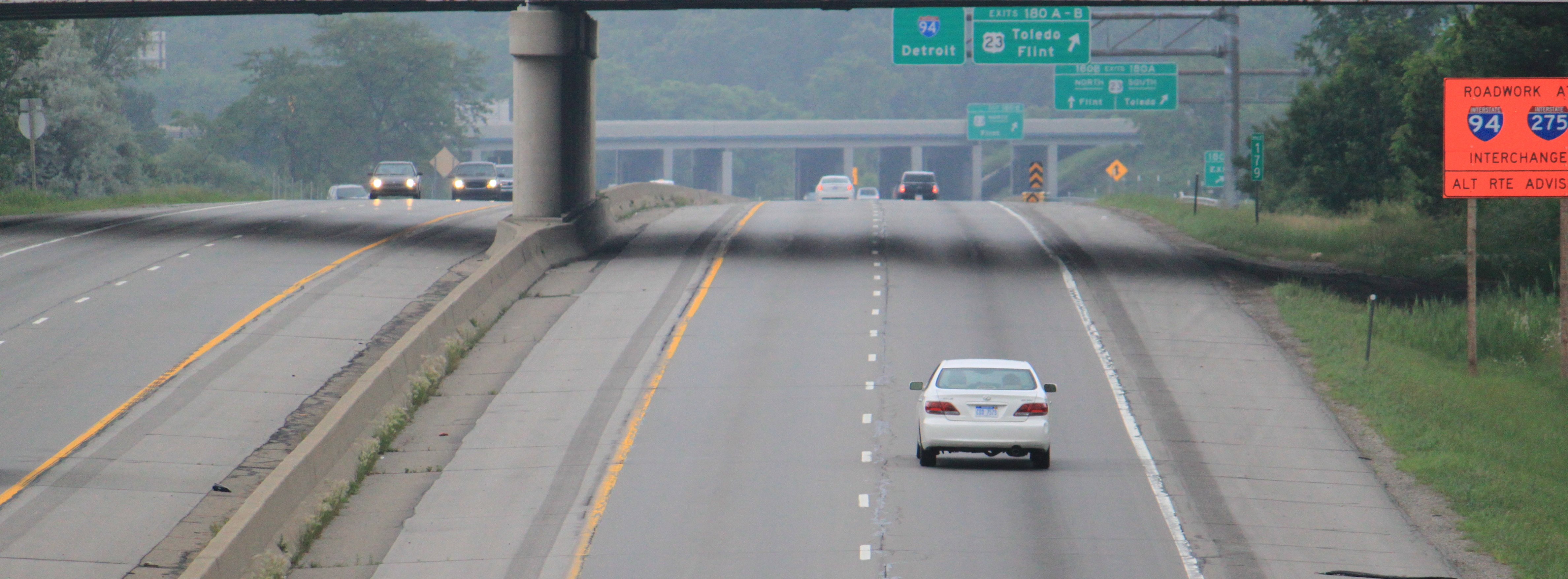
Eastbound exit and westbound entrance Ann Arbor 172 BL I-94 east (Jackson Avenue) – Ann Arbor175 Ann Arbor–Saline Road 177 State Street Pittsfield Township 180 US 23 / BL I-94 west – Ann Arbor, Flint, ToledoSigned as exits 180A (south) and 180B (north) 181 US 12 west (Michigan Avenue) – Ypsilanti, SalineWestern end of US 12 concurrency; signed as exits 181A (west) and 181B (east) westbound Ypsilanti 183 
BUS US 12 east (Huron Street) – Downtown YpsilantiYpsilanti Township 185 US 12 east (Michigan Avenue) – Willow Run AirportEastern end of US 12 concurrency; eastbound exit and westbound entrance 186 Willow Run Airport Westbound exit and eastbound entrance 187 Rawsonville Road Wayne Van Buren Township 190 Belleville Road – Belleville 192 Haggerty Road West access to Lower Huron Metropark Romulus 194  I-275 – Flint, Toledo
Signed as exits 194A (south) and 194B (north) eastbound 196 Wayne Road – Wayne 197 Vining Road 198  Middlebelt Road, Merriman Road – Detroit Metro Airport
Taylor 200 Ecorse Road – Inkster 202  US 24 (Telegraph Road)
Allen Park 204  M-39 (Southfield Freeway) / Pelham Road
206 Oakwood Boulevard Signed as exits 206A (south) and 206B (north) westbound Dearborn 208 Schaefer Road, Greenfield Road 209 Rotunda Drive Westbound exit and eastbound entrance 210A US 12 (Michigan Avenue) / Wyoming Avenue – DearbornSigned as exit 210 eastbound Detroit 210B  M-153 (Ford Road) / Addison Avenue
Westbound exit and eastbound entrance 211A Lonyo Avenue Westbound exit and eastbound entrance 211B Central Avenue, Cecil Avenue Westbound exit and eastbound entrance 212A Livernois Avenue Signed as exit 212 westbound 212B Warren Avenue Westbound exit is via exit 213A 213A West Grand Boulevard 213B I-96 (Jeffries Freeway) – Lansing, Ambassador Bridge to Canada214A Linwood Avenue, Grand River Avenue Signed as exit 214 westbound 214B Trumbull Avenue Eastbound exit and westbound entrance 215  M-10 (Lodge Freeway) – Downtown Detroit, Southfield
Signed as exits 215A (south) and 215B (north) 215C  M-1 (Woodward Avenue) / John R. Street / Brush Street
216A I-75 (Chrysler Freeway) – Flint, Toledo216B Russell Street Eastbound exit only 217 Chene Street, East Grand Boulevard, Mount Elliott Avenue Signed as exits 217A (Chene Street, Grand Boulevard) and 217B (Mount Elliott Avenue) eastbound 218  M-53 (Van Dyke Avenue)
219  M-3 (Gratiot Avenue)
220A French Road No westbound exit 220B Conner Avenue – Detroit City Airport 222A Outer Drive, Chalmers Avenue 222B Harper Avenue Eastbound exit and westbound entrance 223 Cadieux Road 224A Moross Road Harper Woods 224B Allard Avenue, Eastwood Drive 225  M-102 (8 Mile Road, Vernier Road)
Macomb Eastpointe – St. Clair Shores 227 9 Mile Road Eastpointe – Roseville – St. Clair Shores 228 10 Mile Road Roseville – St. Clair Shores 229 I-696 west (Reuther Freeway) / 11 Mile Road – Lansing230 12 Mile Road Roseville 231 M-3 (Gratiot Avenue)Eastbound exit and westbound entrance 232 Little Mack Avenue Clinton Charter Township 234 Harper Avenue Signed as exits 234A (south) and 234B (north) Harrison Township 235 Shook Road Westbound exit and eastbound entrance 236 Metropolitan Parkway Mt. Clemens 237 North River Road – Mt. Clemens Harrison Township – Chesterfield Township 240  M-59 – Selfridge ANG, Utica
Signed as exits 240A (east) and 240B (west) eastbound Chesterfield Township 241 21 Mile Road – Selfridge ANG 243  M-3 / M-29 – Algonac, New Baltimore, Utica
247  M-19 – Richmond, New Haven
Eastbound exit and westbound entrance Lenox Township 248 26 Mile Road – Marine City St. Clair Casco Township – Columbus Township 257 Richmond, St. Clair St. Clair Township 262 Wadhams Road Kimball Township 266 BL I-94 east (Gratiot Road) – MarysvilleSt. Clair Township 269 Range Road, Dove Street 271 I-69 west – Flint, Lansing, Fort Wayne, IndianaWestern end of I-69 concurrency 271  BL I-69 east – Port Huron
Eastbound exit and westbound entrance 274 Water Street, Lapeer Avenue - Port Huron Port Huron 275  BL I-69 west / BL I-94 west / M-25 (Pine Grove Avenue) – Lexington, Downtown Port Huron
Blue Water Bridge over the St. Clair River to Hwy 402 1.000 mi = 1.609 km; 1.000 km = 0.621 mi
Concurrency terminus • Closed/Former • Incomplete access • UnopenedSee also
References
- ^ a b c d Bessert, Christopher J. (October 22, 2006). "Michigan Highways: Highways 90 through 99". Michigan Highways. http://www.michiganhighways.org/listings/MichHwys90-99.html#I-094. Retrieved January 2, 2007.
- ^ "Work to begin April 17 on I-94 project in Benton Harbor" (Press release). Michigan Department of Transportation. April 10, 2006. http://www.michigan.gov/mdot/0,1607,7-151-9620_11057-140620--,00.html.
- ^ American Association of State Highway Officials (1957). Route Numbering for the National System of Interstate and Defense Highways (Map). http://www.roadfan.com/5758int.html.
- ^ Dolley, Brandon. "Detroit-Ann Arbor-Flint Freeways". Detroit Rising. http://www.detroitrising.com/freeways.htm. Retrieved May 30, 2008.
- ^ "US-12 (Michigan) / I-94". Michigan.gov. http://www.michigan.gov/mdot/0,1607,7-151-9620_11154_11188-29352--,00.html.
- ^ "Preliminary List of Nationally and Exceptionally Significant Features of the Interstate Highway System". http://www.environment.fhwa.dot.gov/histpres/highways_list.asp. Retrieved July 6, 2006.
- ^ "MDOT - 1960s". Michigan.gov. http://www.michigan.gov/mdot/0,1607,7-151-9620_11154_39107-106013--,00.html.
- ^ "The Crash". Northwest Flight 255 Memorial. 2003. http://www.flight255memorial.com/thecrash.html. Retrieved June 27, 2010.
- ^ American Automobile Association. 1971 AAA Detroit Southern Suburbs (Map). http://dse.webonastick.com/maps/1971-detroit-suburbs-aaa.
- ^ "Single-Point Urban Interchange (SPUI)". Michigan Department of Transportation. http://www.michigan.gov/mdot/0,1607,7-151-9615_44557-128601--,00.html.
- ^ "I-94 Bridge Builders Go by the Playbook". Detroit Free Press. September 28, 2005.
- ^ "I-94 interchange closes Monday". Battle Creek Enquirer. April 24, 2009. http://www.battlecreekenquirer.com/article/20090424/NEWS01/904240320/1002/NEWS01. Retrieved April 24, 2009.[dead link]
Interstate 94Previous state:
IndianaMichigan Next state:
TerminusAuxiliary routes of Interstate 94 
Freeways in metropolitan Detroit Fisher (I-75) • Edsel Ford (I-94) • Jeffries (I-96) • I-275 • Chrysler (I-375) • Walter Reuther (I-696) Categories:
- Interstate 94
- Interstate Highways in Michigan
- Central Michigan
- Western Michigan
- Lake Michigan Circle Tour


Wikimedia Foundation. 2010.