- M-19 (Michigan highway)
-
This article is about the state highway in Michigan; for other uses, see M19 (disambiguation)
M-19
Route information Maintained by MDOT Length: 84.82 mi[2] (136.50 km) Existed: 1926[1] – present Major junctions South end:  I-94 near New Haven
 I-69 near Port Huron
 M-90 near Brown City
 M-46 in Sandusky
North end:  M-142 near Bad Axe
Location Counties: Macomb, St. Clair, Sanilac, Huron Highway system Michigan State Trunkline Highway System
Interstate • US • State←  M-18
M-18M-20  →
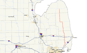
→M-19 is a state trunkline highway in the US state of Michigan. It begins northeast of Detroit at a junction with I-94 and runs northward to a junction with M-142 just east of Bad Axe in the thumb.
Contents
Route description
M-19 begins at a junction with I-94 north of Detroit at exit 247. From there it runs parallel to I-94 until passing through the city of Richmond where it turns northward. Continuing north, beyond Richmond, M-19 travels through mostly rural areas and agricultural fields and continues as such, through the community of Memphis until its junction with I-69, at exit 184, about 15 miles (24 km) west of Port Huron.
From here the route continues north, passing through small, rural communities such as Emmett and Brockway where it has a junction with M-136. North of Brockway the road jogs to the west passing east of the Yale Airport, a small grass landing strip just southeast of the city of Yale. The road jogs to the west again as it passes through Yale where it serves as Main Street in the small community.
After passing through Yale, the surroundings open up into agricultural fields once again as the road continues its trek northward, again passing through small rural communities such as Peck and Speaker. About 26 miles (42 km) north of Yale, the road approaches the city of Sandusky, the county seat of Sanilac County. Near the center of town the route meets up with M-46, and turns west, to form a concurrency that lasts for about five miles (8 km).
After the two routes go their separate ways, M-19 heads back to the north as it enters rural and agricultural areas again. The road heads due north for the next 30 miles (48 km) passing through small communities such as Elmer, Argyle and Ubly, before reaching its northern terminus at M-142 just east of the city of Bad Axe, the county seat of Huron County and the largest city on the route since Richmond.[3]
History
Prior to its current alignment, M-19 existed in a much longer format. Prior to the implementation of the U.S. Highway System in 1926, M-19 began in downtown Detroit and traveled all the way to Port Huron via Gratiot Road, a portion of which is designated M-3 today. The road then traveled to the west via Lapeer and Brandon Roads, part of what used to be M-21 just north of I-69, before turning north on a road similar to its present day alignment. It continued on this road through Yale, Sandusky and Ubly to a junction with M-31, what is now M-142. The route then ran west through town and north along present day M-53 where it terminated in Port Austin at a junction with what was then M-27 (which would later become US 25 and then M-25).
After 1926, when the U.S. Highway System was implemented, a large portion of the southern section of the route - the entire length of Gratiot - was converted into U.S. Route 25; M-19 was then realigned to run straighter to the south through Emmett and Memphis before terminating at the newly designated U.S. Route 25 near Richmond. The portion between Port Huron and Goodells was decommissioned while it retained the M-21 designation. Portions that were bypassed with the new alignment through Emmett and Memphis were turned back to local control. The northern terminus of the route was truncated back to its present day location. In 1963, the southern terminus was extended along former U.S. Route 25 to New Haven (returning the M-19 designation to a portion of Gratiot after 37 years), and then southeasterly along New Haven Road to connect with the newly completed I-94 freeway.[1]
Major intersections
County Location Mile[2] Destinations Notes Macomb Chesterfield Township 0.00 I-94 – Detroit, Port HuronExit 247 on I-94 St. Clair Riley Township 20.95 I-69 – Flint, Port HuronExit 184 on I-69 Brockway Township 27.47  M-136 east – Fort Gratiot
Sanilac Speaker Township 38.60 M-90 west – North BranchSouthern end of M-90 concurrency Peck 41.49 M-90 eastNorthern end of M-90 concurrency Sandusky 53.26 M-46 east – Port SanilacSouthern end of M-46 concurrency Moore Township 58.24 M-46 west – SaginawNorthern end of M-46 concurrency Huron Verona Township 84.82 M-142 – Bad Axe1.000 mi = 1.609 km; 1.000 km = 0.621 mi
Concurrency terminus • Closed/Former • Incomplete access • UnopenedReferences
- ^ a b Bessert, Christopher J. (April 23, 2006). "Michigan Highways: Highways 10 through 19". Michigan Highways. http://www.michiganhighways.org/listings/MichHwys10-19.html#M-019. Retrieved July 25, 2006.
- ^ a b "MiGDL - Center for Geographic Information - Geographic Data Library". Michigan Department of Information Technology. May 2007. http://www.mcgi.state.mi.us/mgdl/?rel=thext&action=thmname&cid=14&cat=MI+Geographic+Framework+All+Roads+%28v7b%29. Retrieved February 9, 2008.
- ^ "Google Maps". Google Maps. http://maps.google.com/. Retrieved February 23, 2008.
External links
Categories:- State highways in Michigan


Wikimedia Foundation. 2010.