- M-53 (Michigan highway)
-
M-53
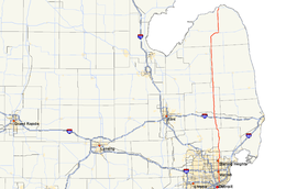
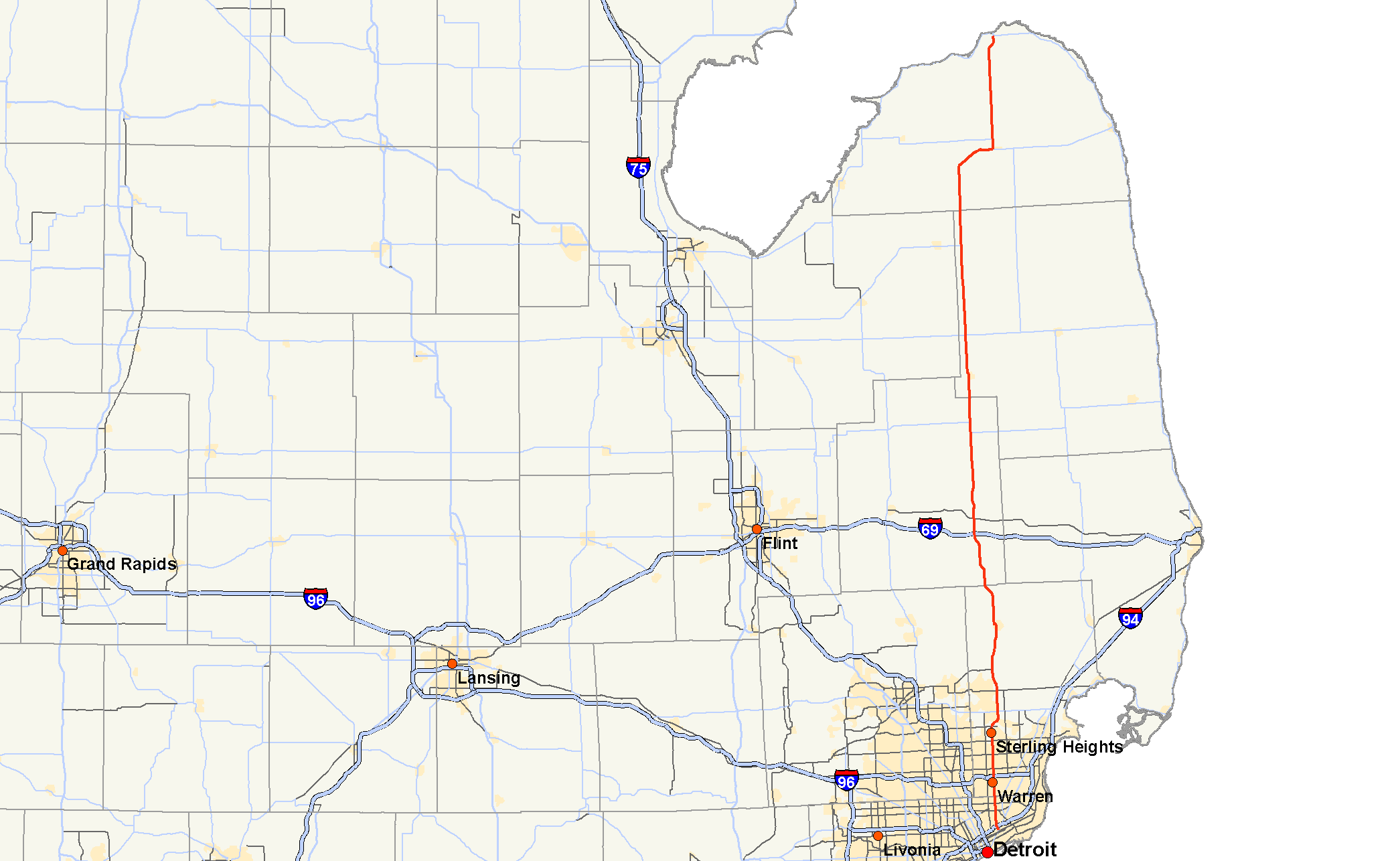
M-53 highlighted in redRoute information Maintained by MDOT Length: 120.87 mi[1] (194.52 km) Existed: 1920 [1] – present Major junctions South end:  M-3 in Detroit
 I-94 in Detroit
 M-102 in Detroit / Warren
 I-696 in Warren
 M-59 in Utica
 I-69 near Imlay City
 M-90 in Burnside
 M-46 near Kingston
 M-81 near Cass City
 M-142 in Bad Axe
North end:  M-25 in Port Austin
Location Counties: Wayne, Macomb, Lapeer, Sanilac, Huron Highway system Michigan State Trunkline Highway System
Interstate • US • State←  M-52
M-52M-54  →
→M-53 is a gateway route to The Thumb region of the US state of Michigan, carrying vacationers to the many cottages and resorts located on Saginaw Bay and Lake Huron in the vicinity of Caseville and Port Austin. This highway is also used to transport agricultural and manufactured products from the Thumb region to the Detroit Metropolitan area. In Macomb County, M-53 (Pinnebog Road) is also a major north–south commuter route.
Contents
Route description
The Van Dyke Freeway, is an 8.75-mile (14.08 km) segment of M-53 that is a controlled-access freeway, unconnected to any other freeways in the state.
This portion of the M-53 freeway was constructed in the 1960s and was envisioned as part of a much larger project to connect the freeways within the city of Detroit with a proposed M-21 (now I-69) freeway near Imlay City. Only the portion from 18 ½ Mile Road in Sterling Heights northerly to north of 27 Mile Road near Washington was built, although a massive freeway-to-freeway interchange was completed along I-696 at Mound Road in Warren in the early 1970s.
As of 2004, the Romeo bypass (continuing on north of the freeway) was upgraded to a limited-access, divided expressway (no private access, but without grade-separated interchanges) and long-range plans are to convert this segment to fully controlled-access freeway in the future.
The M-53 freeway in Macomb County is officially named the Christopher Columbus Freeway and signs are posted with this name at many of the interchanges. Radio traffic reports have been known to use the official name, the colloquial "Van Dyke Freeway" as well as "M-53 Freeway" interchangeably over the years.
Most of the M-53 roadway that runs through the gently rolling agricultural countryside of its northern stretches consists of two lanes, one in each direction. A six-mile (10 km) long section through the orchards near Romeo has been constructed as a limited access highway and is being improved with grade separations. South of Romeo, M-53 becomes a rural controlled access freeway, with two lanes in each direction over a nine-mile (14 km) length. This is followed by three miles (4.8 km) of a six-lane boulevard configuration through the outer-ring suburb of Sterling Heights, while the remainder of the roadway through Warren and Center Line is six traffic lanes with a center turn lane; it is four traffic lanes in Detroit.
M-53 is serviced by I-69 exit 168, south of Imlay City and by I-696 exit 23 on the Warren – Center Line border at 11 Mile Road. M-53 also intersects with M-142 in Bad Axe, M-81 near Cass City, M-46 north of Marlette, M-59 in Utica, and M-102 (Eight Mile Road) on the Warren–Detroit border. M-53 has a four-lane setup in the countryside several miles south of Marlette and most of it consists of a concurrency of M-90.
Maintenance issues
When the freeway section of Van Dyke ends just south of M-59, it becomes a six-lane road with three lanes each way. It is here that funding changes hands, and the condition of the road deteriorates quite severely. Due to the large amount of heavy trucks driving down this road, the road becomes beaten and battered. In addition, Michigan weather takes its toll. Every year, much of the road needs to be rebuilt. However work has slowed quite considerably in the recent year. Many MI residents call for work to resume.[2] Businesses have blamed lost business on customers' lack of desire to use the road. Macomb County has, due to the pressure from taxpayers, agreed to a $700,000 resurfacing effort that will tide the road over until 2011 for a total reconstruction.[3]
Alternate names
The freeway portion of M-53 is officially known as the Christopher Columbus Freeway (a nod to Macomb County's large Italian American population), but it is more commonly called either the Van Dyke Expressway, Van Dyke Freeway or M-53 Freeway. The remaining southerly portion carries the name Van Dyke Avenue and is also known as the Earle Memorial Highway, in honor of Horatio Earle, Michigan's first Highway Commissioner. Beyond the southern terminus of M-53, the roadway continues on as a residential street known as Van Dyke Street until it ends at Jefferson Avenue near the Detroit River. Outside of Detroit, along most of the non-freeway stretches of M-53, the road is commonly known as Van Dyke Road.
History
M-53 was first designated by 1920. It started at Gratiot Avenue in Detroit running north through Centerline, and Utica to eventually end east of Elkton on M-31. A realignment in the city of Detroit moved the highway to Mound Road in 1922. The highway was moved over to Van Dyke Road in Detroit and north into Macomb County in 1925. An extension in 1926 moved the northern terminus to Port Austin along the former M-19. A new route near Imlay City was opened in 1932, with the southern section of the bypass opened by 1937.[1]
M-53 was completely paved by 1940 when the last 11 miles (17.7 km) were paved in Huron and Sanilac counties. The first divided highway section was completed in 1952 in Warren, with an additional 2 miles (3.2 km) completed the following year, completing the divided highway between 12 Mile and 17 Mile roads. Full freeway segments were built in 1965 between 18 Mile and 27½ Mile roads near Utica and Romeo. The plans at the time were to extend the freeway west one mile to Mound Road and then have it continue south along the Mound Road corridor into Detroit (in fact, a 4-level freeway-to-freeway interchange has already been completed at the intersection of Mound Road and I-696 in Warren) to connect with the Davison Freeway and I-96. Construction started on the Romeo Bypass in 1989. Completed in 1992, the bypass extended a two-lane expressway to 34 Mile Road. Further construction on the remaining two lanes was started in 2002. When it was finished in 2003, the highway had two remaining intersections but is otherwise a limited-access freeway. The old highway was transferred to local control and removed from the state trunkline highway system.[1]
Major intersections
County Location Mile Exit Destinations Notes Wayne Detroit 0.00 M-3 (Gratiot Ave) – Roseville, Downtown Detroit0.58 I-94 – Port Huron, ChicagoExit 218 on I-94 1.91 Lynch Road – Detroit City Airport Wayne–Macomb Detroit–Warren 4.89 M-102 (8 Mile Road)8 Mile Road is the county line Macomb Center Line 7.90  I-696 to I-75 – Port Huron, Lansing
Exit 23 on I-696 Sterling Heights 12.99 Metropolitan Parkway Freeway begins 15.24 15 Van Dyke Ave north, 18 ½ Mile Road – Utica Signed as 18 ½ Mile Road southbound 17.55 17 M-59 (Hall Road) – Mt. Clemens, PontiacSigned as 17A (east) and 17B (west) northbound Shelby Charter Township 20.58 20 23 Mile Road Signed as 20A (east) and 20B (west) northbound 23.72 23 26 Mile Road Signed as 23A (east) and 23B (west) northbound Washington Township 25.05 25 Van Dyke Avenue – Romeo Left exit northbound; no exit numbered southbound 27.99 30 Mile Road Cross intersection Romeo 30.17 32 Mile Road – Downtown Romeo Cross intersection Freeway ends Lapeer Imlay Township 44.95 I-69 – Port Huron, FlintExit 168 on I-69 Burnside 59.50 M-90 east – Brown CitySouthern end of M-90 concurrency Burnside Township 60.99 M-90 west – North BranchNorthern end of M-90 concurrency Sanilac Lamotte Township 73.63 M-46 – Sandusky, SaginawGreenleaf Township 85.33 M-81 west – CaroEastern terminus of M-81 Huron Bad Axe 103.57  M-142 east (Sand Beach Rd) to M-19 – Harbor Beach
Southern end of M-142 concurrency Colfax Township 105.24 M-142 west – ElktonNorthern end of M-142 concurrency Port Austin 120.47  M-25 south / LHCT south – Port Hope
South end of M-25/LHCT concurrency 120.86 M-25 west / LHCT west / Spring Street – CasevilleNorth end of M-25/LHCT concurrency 1.000 mi = 1.609 km; 1.000 km = 0.621 mi
Concurrency terminus • Closed/Former • Incomplete access • UnopenedReferences
- ^ a b c d Bessert, Christopher J. (August 26, 2006). "Michigan Highways: Highways 50 through 59". Michigan Highways. http://www.michiganhighways.org/listings/MichHwys50-59.html#M-053. Retrieved October 5, 2006.
- ^ drive michigan | the campaign to improve michigan's roads
- ^ Macomb Daily : Van Dyke set for repaving 07/01/08
External links
Freeways in metropolitan Detroit  Categories:
- State highways in Michigan
- Freeways and expressways in Michigan
- Metro Detroit


Wikimedia Foundation. 2010.