- M-81 (Michigan highway)
-
M-81
Route information Maintained by MDOT Length: 45.64 mi[1] (73.45 km) Existed: 1920 – present Major junctions West end:  M-13 in Saginaw
 I-75 near Saginaw
 M-15 near Reese
 M-24 in Caro
East end:  M-53 near Cass City
Location Counties: Saginaw, Tuscola, Sanilac Highway system Michigan State Trunkline Highway System
Interstate • US • State←  M-80
M-80M-82  →
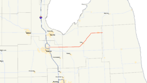
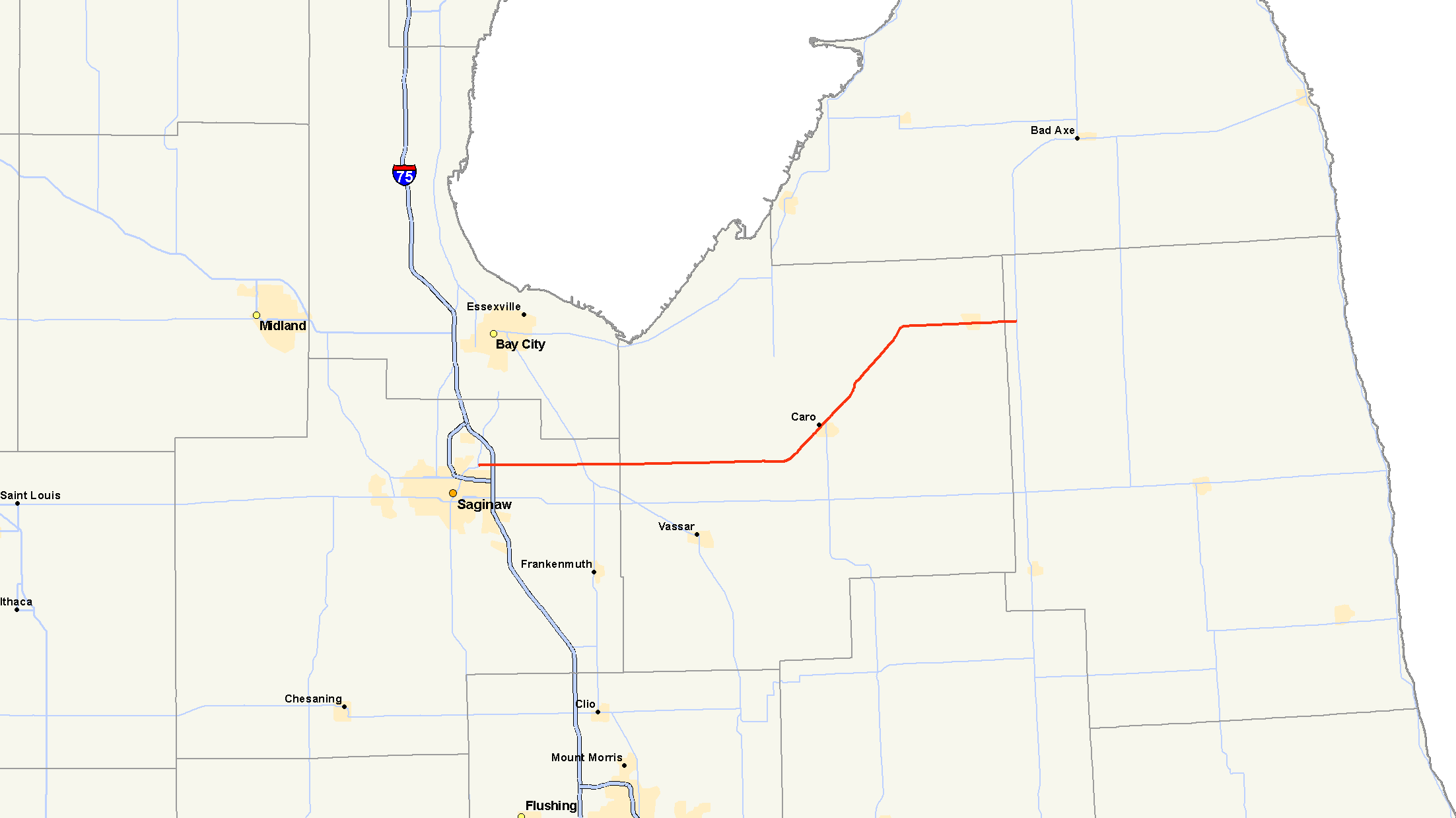
→M-81 is a state trunkline in the Lower Peninsula of the US state of Michigan that travels from the city of Saginaw at the junction with M-13 and ends at the junction with M-53 east of Cass City over the county line in Greenleaf Township in northwestern Sanilac County.
Contents
Route description
M-81 starts at a junction with M-13 and runs east out of Saginaw running through an interchange with I-75. This is exit 151 along I-75. On the way, M-81 passes through the village of Reese and then makes a northeastern curve towards the city of Caro going northeast until it reaches Cass City Road, where it turns and runs directly east again into the village of Cass City. The slant to M-81 through the city of Caro creates a rather strange experience for visitors as they arrive. The roads that intersect with M-81 are not aligned in the proper grid-like structure found in most other cities.[1] All of M-81 is a two-lane highway, except for in the city of Saginaw, where it is a four-lane highway with a center turn lane.
History
When originally formed around 1920, M-81 ran from Reese to Caro. It was extended eastward through Cass City to M-53 in 1922. The initial extension to Saginaw was made in 1926. M-81 would be completely paved in 1946, completing a section between Ellington and Elmwood in Tuscola County.
Prior to 1971, M-81's western terminus formerly ended at M-47 in western Saginaw Charter Township. When I-675 was completed through the city, M-81 was scaled back to its present day terminus at M-13.[1]
Major intersections
County Location Mile[2] Destinations Notes Saginaw Saginaw 0.00 M-13 I-75 – Bay City, FlintExit 151 on I-75 Reese 8.40 M-15 – Bay City, VassarTuscola Caro 27.59 M-24 – Unionville, LapeerSanilac Greenleaf Township 45.64 M-53 – Bad Axe, Imlay City1.000 mi = 1.609 km; 1.000 km = 0.621 mi References
- ^ a b c Bessert, Christopher, J.. "Michigan Highways: Highways 80 through 89". Michigan Highways. http://www.michiganhighways.org/listings/MichHwys80-89.html#M-081. Retrieved October 28, 2006.
- ^ "Control Section/Physical Reference Atlas". Michigan Department of Transportation. 2001. http://mdotwas1.mdot.state.mi.us/public/maps/pr/. Retrieved February 2, 2008.
External links
Categories:- State highways in Michigan

Wikimedia Foundation. 2010.