- M-82 (Michigan highway)
-
M-82
M-82 highlighted in redRoute information Maintained by MDOT Length: 31.492 mi[2] (50.681 km) Existed: 1926[1] – present Major junctions West end:  M-120 near Fremont
 M-37 at Newaygo
East end: 
 US 131 / M-46 at Howard City
Location Counties: Newaygo, Montcalm Highway system Michigan State Trunkline Highway System
Interstate • US • State←  M-81
M-81M-83  →
→M-82 is a state trunkline in the Lower Peninsula in the US state of Michigan that travels between Fremont and Howard City. The section between Newaygo and Howard City travels through Fremont and along the southern edge of Manistee National Forest. The current version of M-82 is actually the second in the state; the first usage appeared in the Upper Peninsula by 1919. The Lower Peninsula routing has been in use since the 1920s. Various extensions and truncations have shifted the terminus as far west as New Era or Hesperia in the past. The current route was finalized in the late 1970s
Contents
Route description
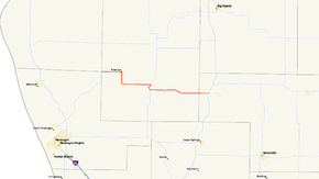
M-82 begins at a junction with M-120 and B-96 east of Fremont. This junction is at a tripoint of county lines. M-120 forms the north–south Newaygo–Oceana and Newaygo–Muskegon county lines. B-96, which forms the east–west Oceana–Muskegon county line runs due west of the intersection. M-82 exits the intersection to the east. The highway runs along 48th Street through rural farms into the community of Fremont. The road, now called Main Street, passes through the downtown area and M-82 turns south along Stewart Avenue out of town. The highway rounds a curve and transitions to 72nd Street running eastward through more farm land. As the trunkline approaches Newaygo, the terrain becomes more wooded near the Muskegon River. M-82 follows Fremont Street east to a junction with M-37. The two highways merge and run concurrently over the river and into downtown on State Street. South of downtown, M-82 turns east again, independent of M-37, and runs along 82nd Street on the southern edge of the Manistee National Forest. The east end of M-82 is at exit 118 on US 131/M-46 west of Howard City.[3][4]
The Michigan Department of Transportation (MDOT), as a part of its maintenance responsibilities, tracks the volume of traffic using its roadways. These levels are expressed in terms of a metric called average annual daily traffic (AADT), which is a calculation of the traffic along a segment of road for any average day of the year. In 2009, the department's measurements indicated that a segment of M-82 west of Fremont had the peak volume for the highway at 16,532 vehicles daily. The traffic nadir was 4,018 vehicles east of Newaygo.[5] In addition, MDOT has not had any section of the highway listed on the National Highway System,[6] a network of roads important to the country's economy, defense, and mobility.[7]
History
Previous designation
The first usage of M-82 was in the Upper Peninsula by July 1, 1919. The trunkline started at M-25 and ran north of Newberry to the vicinity of Eight Mile Corner.[8] It was later replaced by M-48 in 1926.[1]
Current designation
The current M-82 dates back to 1926. It ran from US 31 in Hart to the northern junction of US 131 and M-46 in Howard City. The highway was routed through Ferry, Hesperia and Fremont, replacing M-41.[1][9] In late 1936, M-46 was extended along the section between Newaygo and Howard City, forming a M-46/M-82 concurrency to fill a gap in the M-46 routing.[10][11] This concurrent section became just M-46 in 1938, shortening M-82 back to the northern M-37 junction in Newaygo.[12][13] The highway was moved to a new alignment west of Ferry in late 1947 or early 1948. Instead of heading northwesterly to Hart, it was continued west to end in Shelby.[14][15]
Two realignments in 1963 and 1964 rerouted the western end of the highway again. This time it was realigned to run from Hesperia to New Era, bypassing Ferry.[16][17] A larger change around 1969 reconfigured the highway designations in Oceana County. M-20 replaced M-82 west of Hesperia, to end at New Era instead of Muskegon. The new M-120 designation replaced M-20 south of Hesperia. M-82 now ran from Hesperia to Newaygo only.[18][19] The length of the highway was increased in 1973 when the eastern end was moved back to Howard City. M-46 was rerouted to follow the US 131 freeway south of Howard City to Cedar Springs, and replaced M-57 between Cedar Springs and Casnovia. This freed up the Newaygo to Howard City highway for a return to the M-82 designation.[20][21] The last change came in 1978 when the concurrency with M-120 was eliminated in favor of M-120. The M-82 designation was truncated at this time to the junction west of Fremont, resulting in the current highway routing.[22]
Major intersections
County Location Mile[2] Destinations Notes Muskegon–
Oceana–
NewaygoHolton Townshipa –
Greenwood Townshipb –
Dayton Townshipc –
Sheridan Townshipc0.000 M-120 – Muskegon, Hesperia
 B-86 – Montague
Western terminus is at county tri-point; roadway continues west as B-86 along Muskegon–Oceana county line Newaygo Newaygo 15.025 M-37 north – BaldwinNorthern end of M-37 concurrency through town 16.673 M-37 south – Grand RapidsSouthern end of M-37 concurrency Montcalm Howard City 31.492 US 131 / M-46 – Grand Rapids, Cadillac, SaginawExit 118 on US 131/M-46 1.000 mi = 1.609 km; 1.000 km = 0.621 mi
Concurrency terminus • Closed/Former • Incomplete access • Unopened
aMuskegon County • bOceana County • cNewaygo CountyReferences
- ^ a b c Michigan State Highway Department (December 1, 1926). Official Highway Service Map (Map). Cartography by MSHD.
- ^ a b "MDOT Physical Reference Finder Application". Michigan Department of Transportation. 2009. http://www.mcgi.state.mi.us/prfinder/. Retrieved February 18, 2011.
- ^ Michigan Department of Transportation (2010). Official Department of Transportation Map (Map). 1 in:15 mi/1 cm:9 km.
- ^ Google, Inc. Google Maps – Overview Map of M-82 (Map). Cartography by Google, Inc. http://maps.google.com/maps?f=d&source=s_d&saddr=M-82+E%2FW+48th+St&daddr=M-82+E&hl=en&geocode=FVZClwId-jDf-g%3BFboqlgIddBPn-g&mra=ls&sll=43.424999,-86.093674&sspn=0.466276,0.465546&ie=UTF8&z=10. Retrieved February 18, 2011.
- ^ "Traffic Monitoring Information System". Michigan Department of Transportation. 2008. http://mdotnetpublic.state.mi.us/tmispublic/. Retrieved February 18, 2011.
- ^ Michigan Department of Transportation (April 23, 2006) (PDF). National Highway System, Michigan (Map). http://www.michigan.gov/documents/MDOT_NHS_Statewide_150626_7.pdf. Retrieved October 7, 2008.
- ^ "The National Highway System". Federal Highway Administration. August 26, 2010. http://www.fhwa.dot.gov/planning/nhs/. Retrieved January 1, 2011.
- ^ Michigan State Highway Department (July 1, 1919). State of Michigan: Upper Peninsula (Map). Cartography by MSHD.
- ^ Michigan State Highway Department (July 1, 1919). State of Michigan: Lower Peninsula (Map). Cartography by MSHD.
- ^ Michigan State Highway Department (June 1, 1936). 1936 Official Michigan Highway Map (Map). Cartography by Rand McNally. Section J8–J9.
- ^ Michigan State Highway Department (December 15, 1936). 1936/7 Official Michigan Highway Map (Map). Cartography by Rand McNally (Winter ed.). Section J8–J9.
- ^ Michigan State Highway Department (May 1, 1938). 1938 Official Michigan Highway Map (Map). Cartography by Rand McNally (Spring ed.). Section J8–J9.
- ^ Michigan State Highway Department (December 1, 1938). 1938 Official Michigan Highway Map (Map). Cartography by Rand McNally (Winter ed.). Section J8–J9.
- ^ Michigan State Highway Department (May 1, 1947). 1947 Official Highway Map (Map). Section J8.
- ^ Michigan State Highway Department (April 15, 1948). Michigan Official Highway Map (Map). Section J8.
- ^ Michigan State Highway Department (1962). Official Highway Map (Map). Section J8.
- ^ Michigan State Highway Department (1965). Official Highway Map (Map). Section J8.
- ^ Michigan Department of State Highways (1969). Official Highway Map (Map). 1 in.:14.5 mi.. Cartography by H.M. Gousha. Section J8.
- ^ Michigan Department of State Highways (1970). Official Highway Map (Map). 1 in:14.5 mi. Section J8.
- ^ Michigan Department of State Highways (1973). Official Highway Map (Map). 1 in:14.5 mi. Section J8–J9.
- ^ Michigan Department of State Highways and Transportation (1974). Official Highway Map (Map). 1 in:14.5 mi. Section J8–J9.
- ^ Michigan Department of State Highways and Transportation (1978). Official Transportation Map (Map). 1 in:14.5 mi/1 in:23 km (1978–1979 ed.). Section J8.
External links
Categories:- State highways in Michigan


Wikimedia Foundation. 2010.