- M-83 (Michigan highway)
-
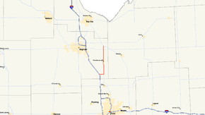
M-83
Route information Maintained by MDOT Length: 14.69 mi[1] (23.64 km) Existed: 1929 – present Major junctions South end: 
 I-75 / US 23 at Birch Run
 M-46 near Frankentrost
North end:  M-15 near Richville
Location Counties: Saginaw Highway system Michigan State Trunkline Highway System
Interstate • US • State←  M-82
M-82M-84  →
→M-83 is a state trunkline in the Lower Peninsula of the US state of Michigan primarily serving as a link between I-75/US 23 and the Bavarian themed town of Frankenmuth known for Bronner's Christmas Wonderland, Zehnder's and the Bavarian Inn.
Contents
Route description
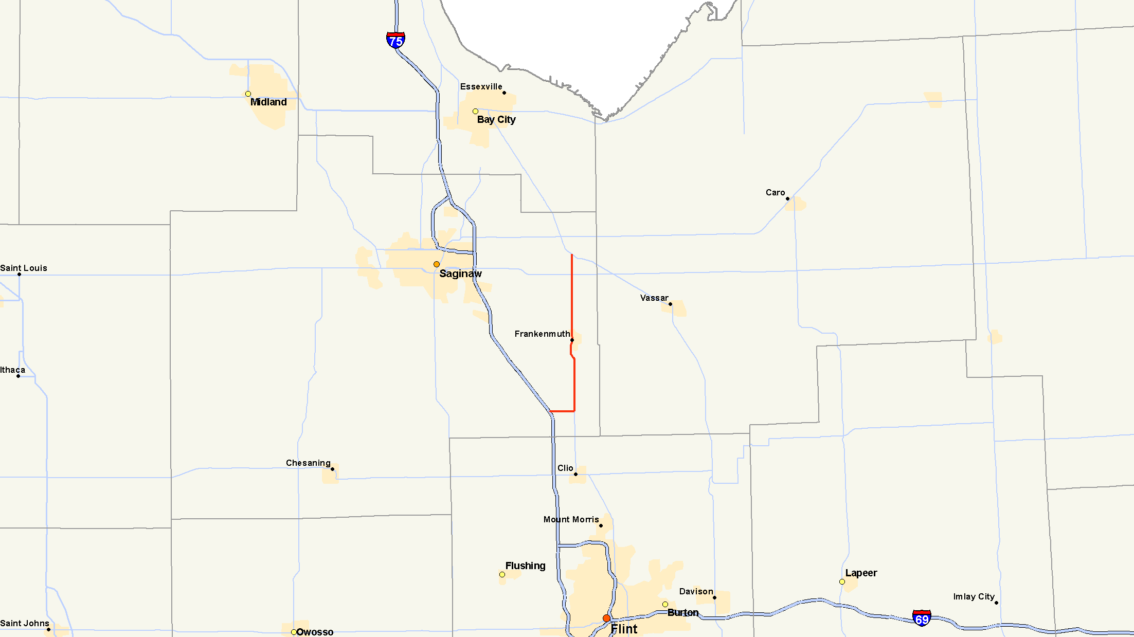
M-83 provides the main access to and from Frankenmuth and I-75/US 23. It starts at exit 136 south of town along the freeway. This exit is also the northern terminus of M-54. The two run east from the freeway along Birch Run Road crossing Dixie Highway. At the intersection with South Gera Road, they diverge. M-83 turns north and M-54 turns south. From here, M-83 runs north past Bronner's Christmas Wonderland and into Frankenmuth along Main Street crossing the Cass River. North of town, M-83 intersects M-46/Holland Road before ending at M-15 near Richville
Bronner's Christmas Wonderland
Main article: Bronner's Christmas WonderlandBronner's Christmas Wonderland is a retail store in Frankenmuth that bills itself as the "World's Largest Christmas Store." Designed with an Alpine architecture and operating year-round, the building covers 7.35 acres (29,744 m2) and landscaped grounds covering 27 acres (109,265 m2). Outside the entrance are three 17-foot (5 m) tall outdoor Santas and a 15-foot (5 m) tall snowman. Inside, there are some 800 animated figurines at various locations throughout the store.
History
Previous designation
The first designation of M-83 was in place by July 1, 1919 for a routing along the Mohawk–Gay Road between the communities of the same name in Keweenaw County.[2] This designation lasted until around 1927 when it was replaced by a northerly extension of M-26.[3] The second designation of M-83 replaced M-31 across The Thumb between Bay Port and Harbor Beach along what is today M-142.[3][4]
Current designation
The current designation was assigned in 1929 as a second, disconnected section of highway. This new routing ran from US 10/US 23 in Clio by way of Frankenmuth to Reese.[5] The gap between the two sections was filled in a year later when M-84 in Tuscola County is redesignated as part of M-83. After this change, M-83 continues north from Reese through Gilford and Akron to Unionville. There it runs concurrently along M-29 to Bay Port, connecting the two segments.[6][7]
The eastern segment first designated in 1927 was separated from the rest of the highway in 1939. The northern end was scaled back to M-15/M-24 in Saginaw County. The concurrency along M-81 was removed, the section northeast to Gilford was transferred to local control, and the section northeast of Guilford to Unionville was added to M-138. The Bayport – Harbor Beach section was redesignated M-142.[8][9] The last changes came around 1962 when the I-75/US 10/US 23 freeway was completed between Pontiac and Flint. M-83 was rerouted on its south end to turn west along Birch Run Road to the freeway, concurrent with the new M-54, which replaced M-83 south of Birch Run Road.[10][11]
Major intersections
The entire highway is in Saginaw County.
Location Mile Destinations Notes Birch Run 0.00 I-75 / US 23 – Saginaw, Flint
 M-54 ends
Southern terminus concurrent with M-54 northern terminus at exit 136 on I-75/US 23 Birch Run Township M-54 south – FlintEastern end of M-54 concurrency Blumfield Township M-46 – Saginaw, Sandusky14.69 M-15 – Bay City, Pontiac1.000 mi = 1.609 km; 1.000 km = 0.621 mi
Concurrency terminus • Closed/Former • Incomplete access • UnopenedReferences
- ^ Michigan Highways: Highways 80 through 89 Christopher J. Bessert. URL Accessed October 28, 2006.
- ^ Michigan State Highway Department (1919). State of Michigan: Upper Peninsula (Map). Cartography by MSHD. http://maps.lib.msu.edu/miroadmaps/1919_up.htm. Retrieved March 2, 2008.
- ^ a b Michigan State Highway Department (December 1, 1927). Official Highway Service Map (Map). Cartography by MSHD.
- ^ Michigan State Highway Department (1919). State of Michigan: Lower Peninsula (Map). Cartography by MSHD. http://maps.lib.msu.edu/miroadmaps/1919-lp.htm. Retrieved March 2, 2008.
- ^ Michigan State Highway Department (May 1, 1929). Official Highway Service Map (Map). Cartography by MSHD.
- ^ Michigan State Highway Department (January 1, 1930). Official Highway Service Map (Map). Cartography by H.M. Gousha.
- ^ Michigan State Highway Department (July 1, 1930). Official Highway Service Map (Map). Cartography by H.M. Gousha.
- ^ Michigan State Highway Department (April 15, 1939). 1939 Official Michigan Highway Map (Map). Cartography by Rand McNally (Summer ed.).
- ^ Michigan State Highway Department (December 1, 1939). 1939 Official Michigan Highway Map (Map). Cartography by Rand McNally (Winter ed.).
- ^ Michigan State Highway Department (1962). Official Highway Map (Map).
- ^ Michigan State Highway Department (1963). Official Highway Map (Map).
External links
Categories:- State highways in Michigan

Wikimedia Foundation. 2010.