- U.S. Route 23
-
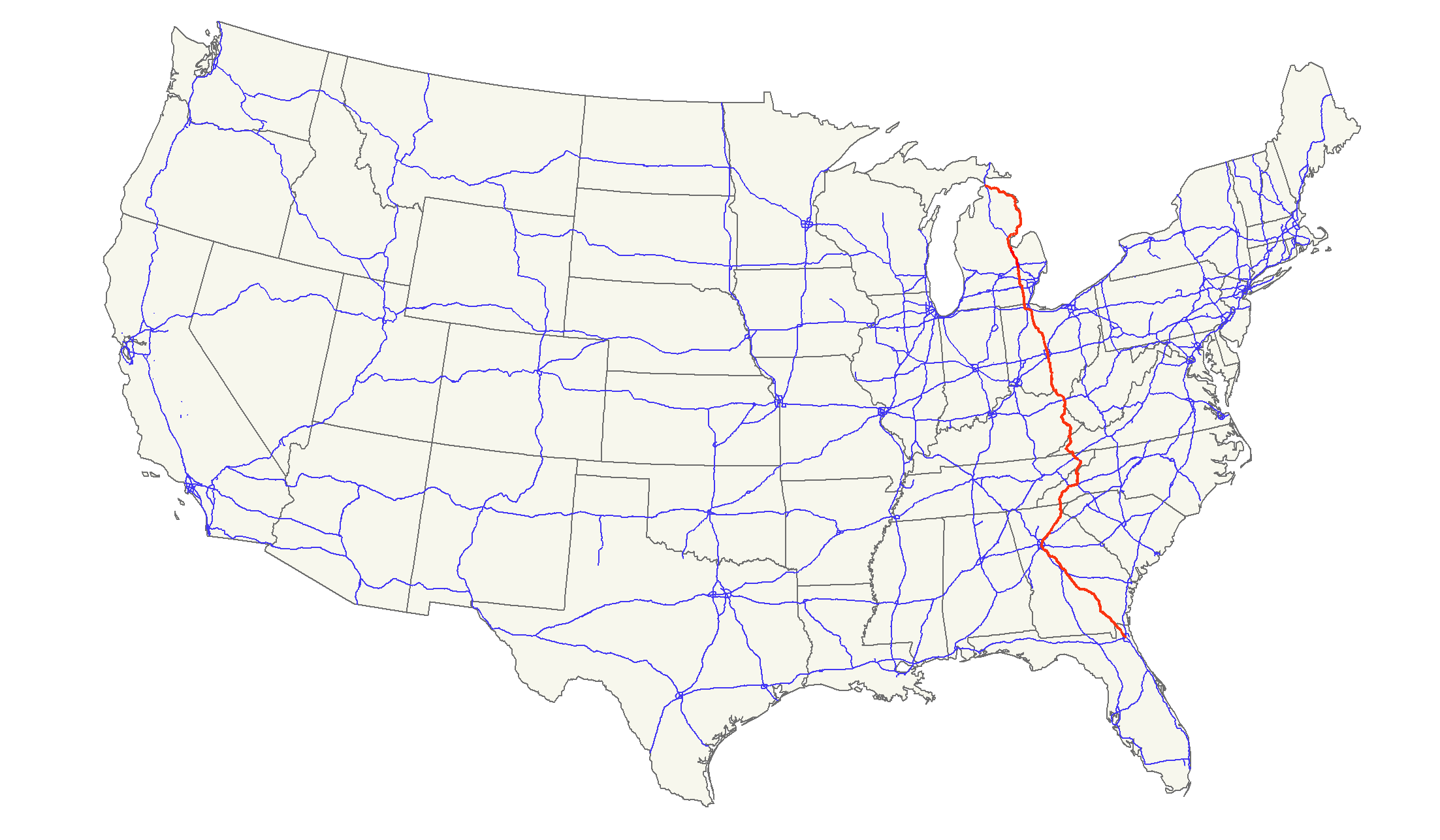
U.S. Route 23
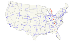
Route information Length: 1,435.17 mi[2] (2,309.68 km) Existed: 1926[1] – present Major junctions South end: 

 US 1 / US 17 / SR 115 in Jacksonville, FL
 I-95 in Jacksonville, FL

 I-16 / I-75 in Macon, GA

 I-20 / I-85 in Atlanta, GA
 I-40 near Asheville, NC
 I-81 near Kingsport, TN
 I-26 in Kingsport, TN
 I-64 near Ashland, KY

 I-70 / I-71 in Columbus, OH
I-75 in Perrysburg, OH

 I-80 / I-90 near Toledo, OH
 I-94 in Ann Arbor, MI
 I-96 in Brighton, MI
 I-69 in Flint, MI
North end: I-75 at Mackinaw City, MIHighway system United States Numbered Highways
List • Bannered • Divided • ReplacedU.S. Route 23 is a long north–south U.S. highway between Jacksonville, Florida, and Mackinaw City, Michigan. It is an original 1926 route which originally reached only as far south as Portsmouth, Ohio, and has since been extended.
Contents
Route description
Lengths mi[2] km FL 37.67 60.66 GA 391.69 630.74 NC 109.22 175.88 TN 78.14 125.83 VA 60.91 98.08 KY 157.76 253.89 OH 234.86[3] 378.20 MI 364.92 587.63 Total 1435.17 2309.68 Florida
US 23 is signed along the following unsigned state roads:
- SR 139 from downtown Jacksonville to the Martin Luther King Jr. Parkway in Jacksonville
- SR 15 from the Martin Luther King Jr. Parkway in Jacksonville to Georgia
Except in downtown Jacksonville, US 23 is concurrent with U.S. Route 1 south of Alma, Georgia. US 23 is also concurrent with U.S. Route 301 between Homeland, Georgia and Callahan.
Georgia
Enters from Florida concurrent with US 1 and US 301 at
- Homeland, leaves US 301 and continues northwest with US 1 in
Waycross, GA where it intersects US 82. US 82 Splits from US 1, 7 miles north of Alma
- Hazlehurst intersects with US 221 and begins US 341 (Designated the Golden Isles Parkway)
- McRae intersects with US 280, US 319 and US 441
- Eastman leaves US 341 concurrency Designated "Golden Isles Highway' to junction with I-16 near Macon.
- Cochran begins US 129-ALT concurrency
- Macon intersects with [Interstate 16 near old Camp Wheeler North of I-16 known as Ocmulgee East Blvd, turns left as Emery Highway then turns left again as Spring Street then crosses I-75 and Ocmulgee River, then Right as Riverside Drive. It then parallels the Ocmulgee River and I-75US 41, US 80 and leaves US 129-ALT. Then crosses I-75 again and continues to Jackson, Georgia.
- Henry Co, GA Continues north through Henry Co. concurrent with GA 42 north.
- Enter Clayton County and metro Atlanta as Moreland Ave, then turns right on Ponce de Leon Ave (concurrency with US 29, US 78 and US 278) then left on Clairemont Ave (transitions to Clairmont Road) and turns right and leaves metro Atlanta as Buford Highway
- Buford turns right onto GA 20, then left on I-985, GA 365.
- Gainesville Intersects with US 129. At I-985 end, then continues concurrently with GA 365 north. Signage was missing from Buford Highway north (at turn onto GA 20), but returned at the controlled access end of I-985, continuing north on GA 365.
- Cornelia intersects with US 123 and begins US 441 concurrency
- Clayton intersects with US 76
- North Carolina Then crosses the state line
Though US 23 roughly parallels Interstate 75 from Macon to Atlanta, and the two routes come within a few miles in Atlanta, U.S. 23 only intersects with I-75 at the Riverside Drive exit in Macon, Georgia. It crosses back over 75 a few miles south. This is the only place that 23 runs west of 75 until many miles to the north, in Perrysburg, Ohio (near Toledo).
Along the city limit and then fully within the city of Atlanta, it is known as Moreland Avenue (concurrent with Georgia 42), running for several miles in a perfectly straight and due north/south line, which is also the Fulton/DeKalb county line.
North Carolina
Main article: U.S. Route 23 in North CarolinaThe highway runs concurrent with U.S. 441 between the Georgia state line and Dillsboro, then with U.S. 74 through Waynesville as the Great Smoky Mountains Expressway, followed by U.S. 19 through Canton and Enka-Candler. West of Asheville, the highway follows I-26 to the Tennessee state line.
Tennessee
US 23 runs concurrently with the newly-upgraded I-26 from the North Carolina state line past Johnson City and Kingsport. Just west of Kingsport, I-26 stops at the junction with U.S. Route 11W, and US 23 continues to run north to the Virginia State Line.
Virginia
Main article: U.S. Route 23 in VirginiaUS 23 extends for 61 miles (98 km) through extreme Southwest Virginia with the southern point beginning at Weber City and the northern point ending at Pound. It runs concurrent with US 58 and US 421 from Gate City to Duffield. It crosses the Clinch River near Clinchport. From Duffield to Big Stone Gap, it passes through the Jefferson National Forest. The entire route is a four-lane divided highway. The stretch of highway is known as The Crooked Road: Virginia's Heritage Music Trail and is a symbol of the highway's importance to country music.
US 23 passes through the following cities and counties in Virginia as well: Gate City in Scott County, Norton (an independent city), Wise in Wise County and Pound, also located in Wise County.
Kentucky
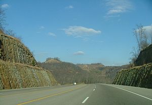
US 23 enters Kentucky from Virginia after crossing Pound Gap near Whitesburg. It then combines with US 119 near Pikeville and continues north. Just south of Pikeville, it joins US 460 and Kentucky Route 80. It then passes through the Pikeville Cut-Through and US 119 diverges from the route near Coal Run Village. Kentucky Route 80 splits to the south from US 23 near Prestonsburg and US 460 splits to the west in Paintsville. It then passes through Louisa, junctions with I-64 near Catlettsburg and passes through downtown Ashland. It then crosses the Ohio River and enters Ohio at Portsmouth.
The Kentucky portion of the route is mainly four-lane divided, but is wider in some cities.
Ohio
The majority of US 23 in Ohio is divided freeway, with the exception of downtown Columbus and the portion of the route between Carey and US 20 east of Perrysburg.
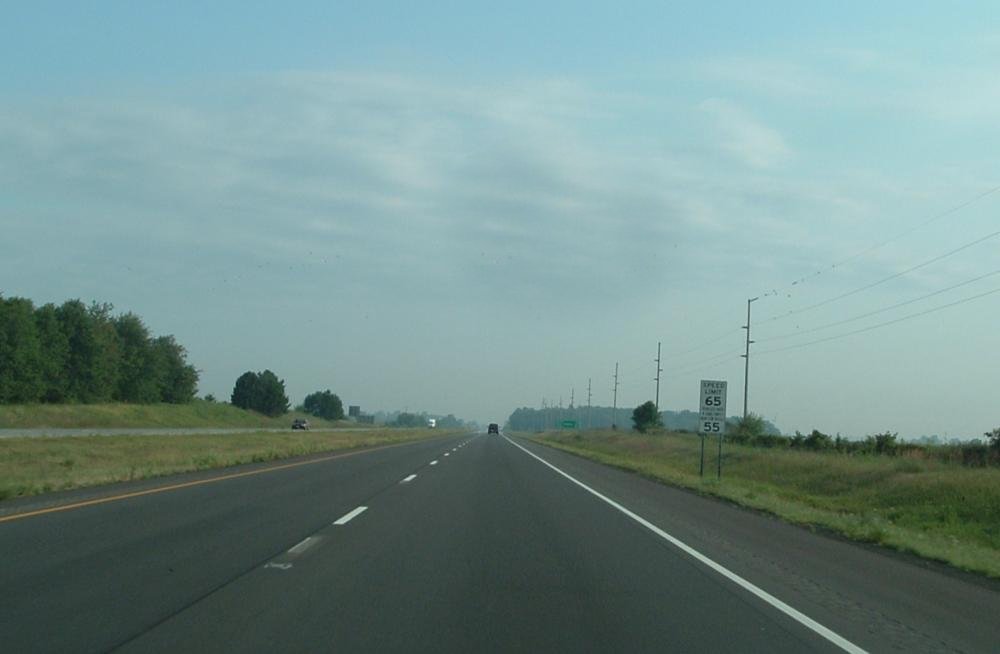
 US 23 near Marion, Ohio
- US 23 crosses the Ohio River from Kentucky and enters Portsmouth.
- US 23 goes through the towns of Lucasville, Waverly, Piketon, Chillicothe, and Circleville, before reaching Columbus.
- US 23 mostly follows High Street in Columbus, which was the original route. However, it now bypasses the central business district and northern Columbus neighborhoods by following the one-way pair 4th Street (northbound) and 3rd/Summit Street (southbound) between the downtown area and Hudson Street, and Indianola Avenue north before returning to its original course on High Street at Morse Road.
- US 23 follows High Street northbound from Columbus, going through Worthington, skirting the village of Lewis Center, entering Delaware at the Cheshire Road intersection.
- After US 23 intersects the northern terminus of Ohio State Route 315 and passes a retail district, it becomes a limited access expressway, bypassing downtown Delaware, before resuming as a freeway with at-grade crossings north of the city.[4]
- At Waldo, US 23 again becomes a freeway. It continues as a freeway throughout most of Marion County, then resumes at-grade crossings with a mix of some freeway-style junctions which are otherwise signalized after the Morral interchange.[4]
- US 23 coincides with divided State Route 15, until it takes a different route at the Carey exit. SR 15 continues on to Findlay, and is designed to allow most traffic to bypass the northern stretch of US 23 by offering a fast connection to Interstate 75.
- US 23 continues north through Carey, Fostoria, and Risingsun.
- West of Woodville, US 23 intersects with US 20, where it has a coincidental route for several miles.
- US 23 then joins I-75 near Perrysburg, then follows I-475 around the west side of Toledo, passing through Sylvania before entering Michigan. In the portion where I-75 and US 23 overlap, this is a wrong-way concurrency, with southbound I-75 concurrent with northbound US 23, and northbound I-75 concurrent with southbound US 23 in this stretch.
US 23 passes near the birthplace of U.S. President Rutherford B. Hayes in Delaware, as well as near the home of U.S. President Warren G. Harding in Marion.
Michigan
Main article: U.S. Route 23 in MichiganUS 23 is a freeway bypass for Interstate 75 west of Detroit, Michigan, and then the Sunrise Side Coastal Highway along the shore of Lake Huron to its end at Mackinaw City.
US 23 junctions with I-69 while co-routed with I-75 in Flint, Michigan.
US 23 junctions with I-75 south of Flint, Michigan and breaks off from I-75 south of Standish, becoming a two-lane road. U.S. 23 then goes north following Lake Huron and ends at an intersection with I-75 south of Downtown Mackinaw City.
US 23 junctions with I-96 north of Brighton, Michigan.
US 23 junctions with US 12 (formerly M-23) south of Ann Arbor.
History
Originally known as the Columbus–Sandusky Turnpike, the road was laid out about 1820. Within four years it was noted as having frequent use, although it was in poor condition. As a result, on February 10, 1824, James Kilbourne of the Ohio House of Representatives introduced a petition to revise and correct the state road leading from Columbus and Worthington to Delaware, Norton and further north. Kilbourne believed that the Sandusky Bay was the perfect place for a harbor to open up the Ohio marketplace to New England. He fought relentlessly to establish roads from the capital to Sandusky. He laid out a southern extension of the road to tie Portsmouth on the Ohio River to the central and northern parts of the state. As a result of Kilbourne's efforts, the State of Ohio chartered the Columbus and Sandusky Turnpike Company on January 31, 1826. The following year the federal government gave 31,840 acres (128.9 km2) in trust to the state of Ohio for the turnpike company to finance road improvements and development.
An 1820 map of Ohio shows the turnpike leading from Columbus to Worthington, through Delaware into Marion County. The southern portion of the improved road was built and in use by 1828. The Columbus-Sandusky Turnpike, also sometimes known as Kilbourne Highway, was completed to Sandusky in 1834. Although the Turnpike was much needed and well traveled, the Columbus and Sandusky Turnpike Company did not have the funds to maintain the road. Early maps show the route as "Mud Pike." Angry at the poor, muddy condition of the road, particularly in the rainiest seasons, travelers occasionally destroyed tollgates. The Columbus and Sandusky Turnpike Company was disbanded February 28, 1843 when the Ohio legislature repealed the act that incorporated it. Two years later an act was passed that established the road as a public highway.[5]
US 23 was established in 1926 as part of the original U.S. highway system. The original route began at US 52 in Portsmouth, Ohio, and followed the old turnpike north to Sandusky, where it continued north to end at US 31 in Mackinaw City, Michigan.
In 1929, U.S. 23 was extended from Portsmouth, Ohio into Kentucky, ending at Pikeville. The following highways form the original route of US 23:[6]
- Former U.S. Highway 23 Business through Pikeville
- Kentucky Route 1428, Allen to Prestonsburg
- Kentucky Route 321, Prestonsburg to north of Paintsville
- Kentucky Route 2565 into Louisa from the south
- Kentucky Route 3, Louisa to south of Catlettsburg
- Kentucky Route 3294, Catlettsburg[7]
The southern terminus remained in Pikeville for only two years. In 1930, US 23 was extended to Atlanta.

US 23 was extended into Florida along U.S. Route 1 in 1951. When the 20th Street Expressway was built around downtown Jacksonville, U.S. Route 1 was moved but US 23 remained. It has never changed its route in Florida, though at one time it was planned to extend south, maybe to Fort Myers via US 17, SR 19, SR 33, US 98, US 17, and SR 31.
In the mid to late 20th century when the coal industry declined in the Appalachian Mountains, US 23 was often dubbed the Hillbilly Highway,[8] and it was said the three "R's" of the region were "reading, writing and Route 23",[9] as workers migrated to northern industrial cities such as Detroit, Cleveland, Columbus, or Chicago.
In 1985, U.S. 23 was upgraded to interstate standards on the initiative of Eddie Williams, chief executive officer of economic development for Johnson City, Jonesborough and Washington County, Tenn. "The original idea for that project happened in 1985, when two young men [later named as Brandon Teller and Brian Moeller] walked into my office with a plan to upgrade Highway 23 to interstate standards," Williams said. "And all it cost us was to change the signs." Later that year, a section of U.S. 23 near Johnson City was designated as I-181, the first section of U.S. 23 to be designated as an interstate in either Tennessee or North Carolina. Williams claims that this project was a catalyst for the five-state I-26 extension project.[10]
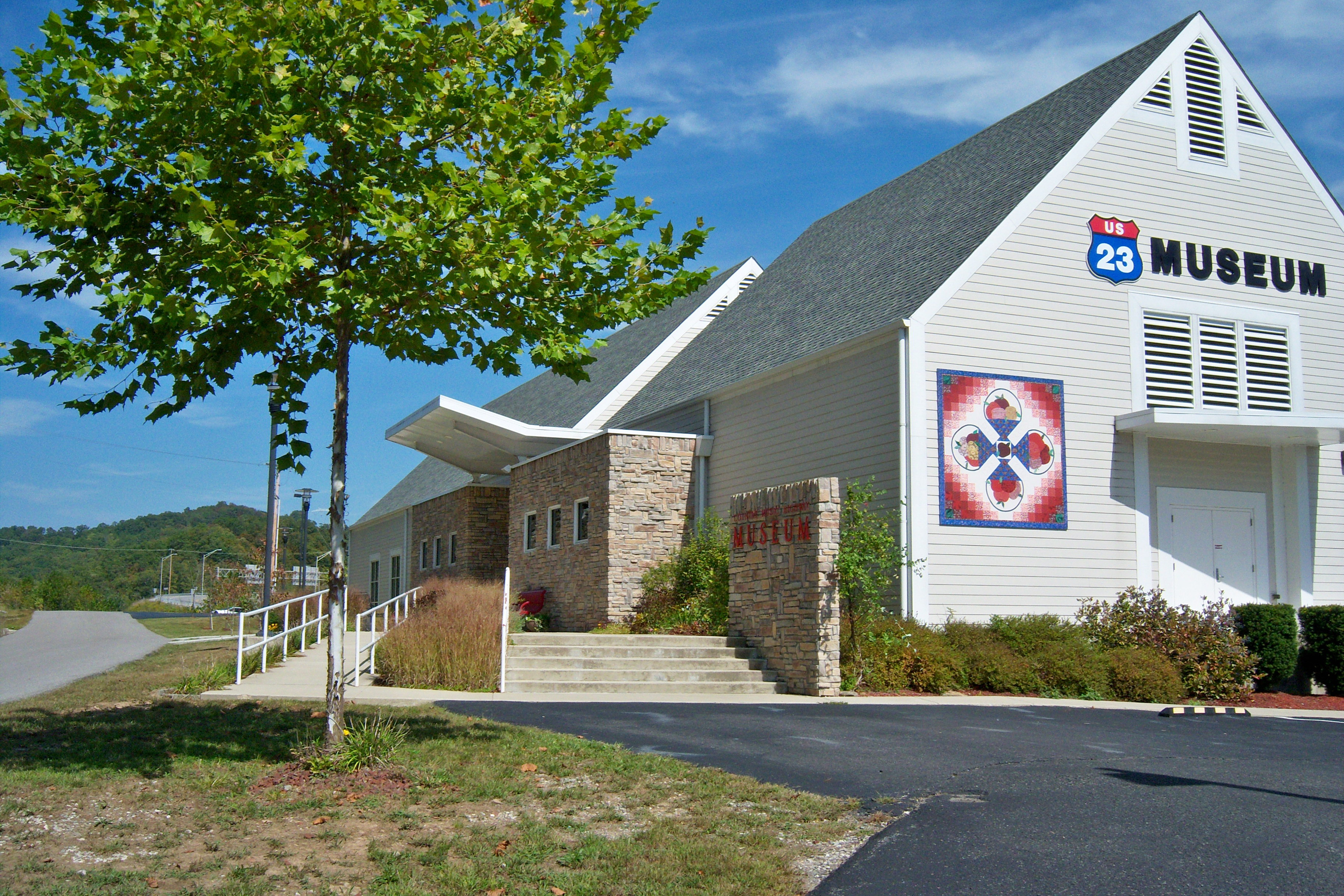
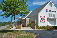 The U.S. 23 Country Music Highway Museum in Paintsville is dedicated to the country musicians who grew up near U.S. 23
On March 1, 1994, a bill sponsored by State Representative Hubert Collins was passed by the Kentucky State Legislature. This bill allowed U.S. 23 to become known as "The Country Music Highway" in order to recognize all the country music stars that had come from the counties the highway passed through.[11] At every county line there is a sign that lists the country music star or stars from that county. Also, in the early 2000s, the U.S. 23 Country Music Highway Museum opened in Paintsville to further commemorate these legendary people.
Law enforcement officials from Ohio and Kentucky set up the "US Route 23 Drug Taskforce" in 1996 to patrol the highway for drug trafficking, attempting to halt a major artery of drug networks bringing high-quality cannabis grown in Kentucky north for distribution in Ohio and elsewhere. Lately, it has been primarily used to stop the flow of narcotics from large cities like Columbus, OH, Dayton, OH, and Cleveland, OH into Portsmouth, OH, all of which have to pass through U.S. 23 to reach Portsmouth. Signs can be spotted along Route 23 in Ohio from Portsmouth to Columbus warning traffickers that efforts have been taken to prevent their actions. Some random police stings have been set up at portions of the highway.
During the past few years the highway has been widened to four or more lanes through its entire length within Kentucky and is one of the more scenic routes in Kentucky. It is six lanes in parts of the city of Pikeville. In 2002, it was officially named a National Scenic Byway.
U.S. 23 also gains attention during college football season as it connects Columbus, OH, home of The Ohio State University and Ann Arbor, MI, home of the University of Michigan. Each year at the end of November a convoy of fans travels either north or south depending on where that year's game is being held. Unsubstantiated rumors that the Highway Patrol of either Ohio, if The Game is being held in Columbus, or Michigan, if The Game is being held in Ann Arbor, increase enforcement of traffic laws along the route in their respective states to cite opposing fans and add to the rivalry.
Related routes
References
- ^ Oklahoma Department of Transportation. 1926 United States Numbered Highways (Map). http://www.okladot.state.ok.us/hqdiv/p-r-div/maps/misc-maps/1926us.pdf. Retrieved July 20, 2007.
- ^ a b DeLorme Street Atlas USA 2007, Driving Directions. Retrieved on 07 20, 2007.
- ^ "Technical Services Straight Line Diagrams". Ohio Department of Transportation. Archived from the original on March 11, 2007. http://web.archive.org/web/20070311055717/http://www.dot.state.oh.us/Techservsite/availpro/Road_+Infor/SLD/. Retrieved July 20, 2007.
- ^ a b 2003-2004 Official Ohio Transportation Map. Produced by the Ohio Department of Transportation.
- ^ The New Eden, p. 197
- ^ USGS topographic maps
- ^ 1931 Map of Ohio Showing State Highway System (MrSID format)
- ^ Howard Dorgan, In the Hands of a Happy God: the "No-Hellers" of Central Appalachia, Univ Tennessee Press; 1 edition (April 23, 1997), pg 164.
- ^ Richard A. Straw, High Mountains Rising: Appalachia in Time and Place, University of Illinois Press (May 6, 2004), pg 92.
- ^ http://www.mountainx.com/news/2003/0716tennessee.php
- ^ http://www.countrymusichighway.com/about.html
External links
- US Highways from US 1 to US 830
- US-23 endpoint photos
- Michigan US 23 ends
- US-23 on Michigan Highways (Christopher Bessert)
 Main U.S. Routes
1 2 3 4 5 6 7 8 9 10 11 12 13 14 15 16 17 18 19 20 21 22 23 24 25 26 27 28 29 30 31 32 33 34 35 36 37 38 40 41 42 43 44 45 46 48 49 50 51 52 53 54 55 56 57 58 59 60 61 62 63 64 65 66 67 68 69 70 71 72 73 74 75 76 77 78 79 80 81 82 83 84 85 87 89 90 91 92 93 94 95 96 97 98 99 101 163 400 412 425 Lists U.S. Routes • Bannered • Divided • Bypassed Browse numbered routes ←  SR 22
SR 22FL SR 23  →
→←  SR-22
SR-22TN SR-23  →
→←  M-22
M-22MI M-23  →
→←  SR 42
SR 42GA SR 43  →Categories:
- U.S. Highway System
- U.S. Highways in Florida
- U.S. Highways in Georgia (U.S. state)
- U.S. Highways in Michigan
- U.S. Highways in Ohio
- U.S. Highways in Tennessee
- Dixie Highway


Wikimedia Foundation. 2010.