- Roads and freeways in metropolitan Detroit
-
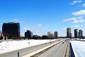
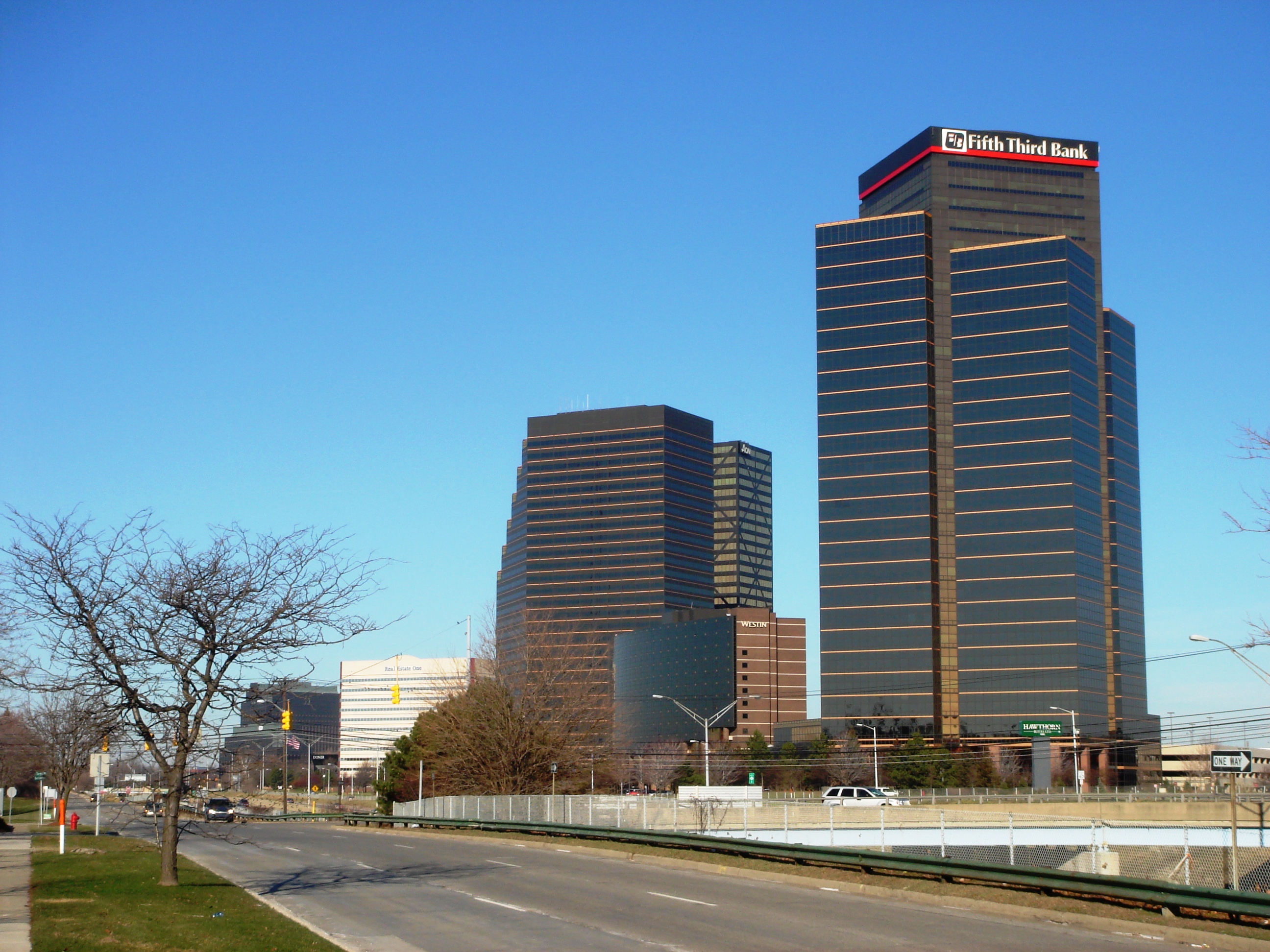
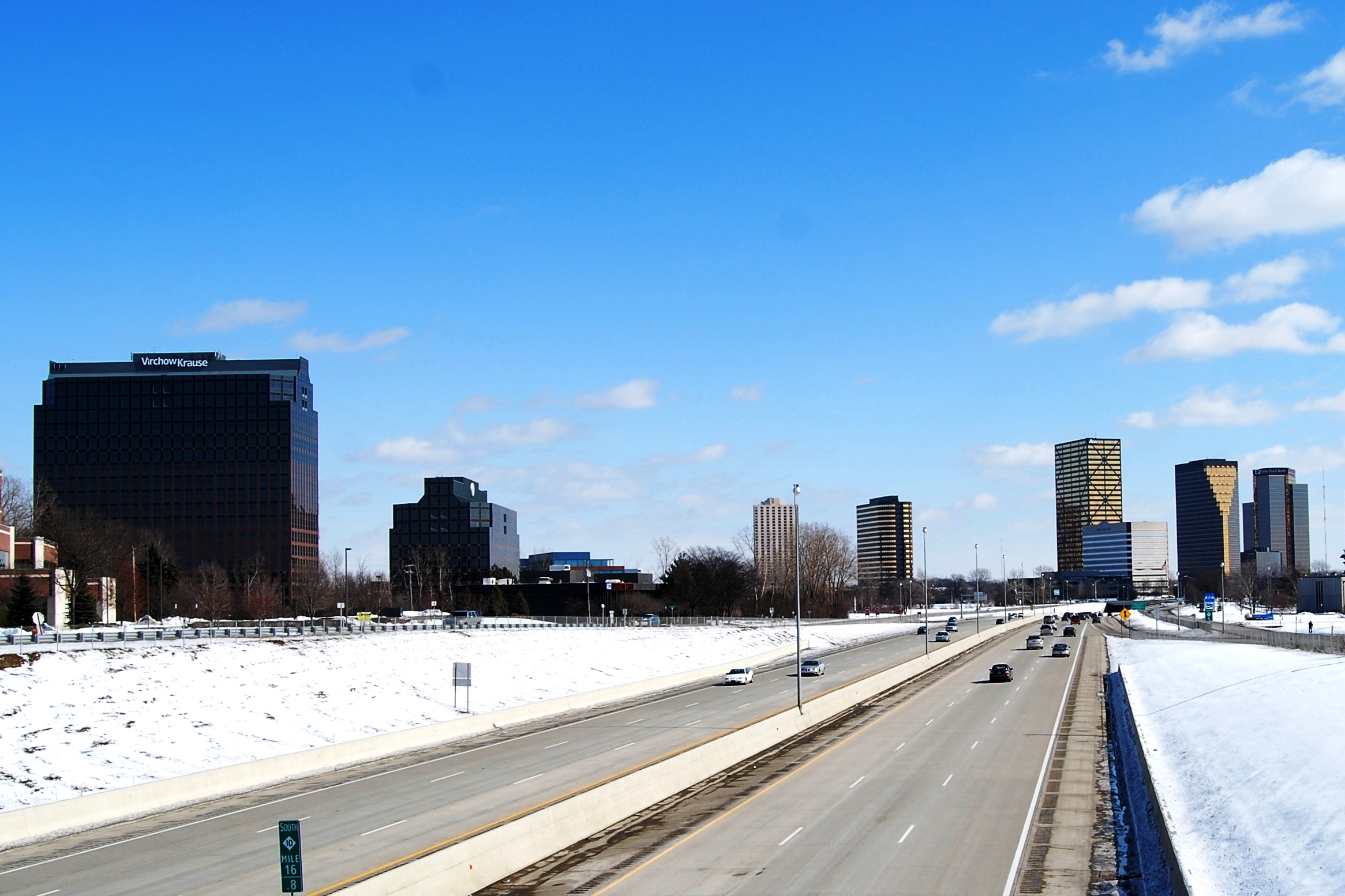
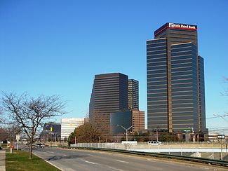 View of southbound lanes of Northwestwestern Highway in Metro Detroit passing beside John C. Lodge Freeway M-10 which is sunken below street level in front of the Southfield Town Center.
The Roads and freeways in metropolitan Detroit comprise the main thoroughfares in the region. The freeways consist of an advanced network of interconnecting freeways which include Interstate highways. The Metro Detroit region's extensive toll-free expressway system, together with its status as a major port city, provide advantages to its location as a global business center.[1] There are no toll roads in Michigan.[2]
Traditionally, Detroiters referred to their freeways by name rather than route number. That is still true today, with many Detroiters calling the freeways by their names, but numbers are in use as well. Other freeways are referred to only by number as in the case of I-275 and M-59: their names, if any, were never in common everyday usage. M-53, while not officially designated, is commonly called the Van Dyke Expressway. Detroit area freeways are typically sunken below ground level to permit local traffic to pass over the freeway.[3]
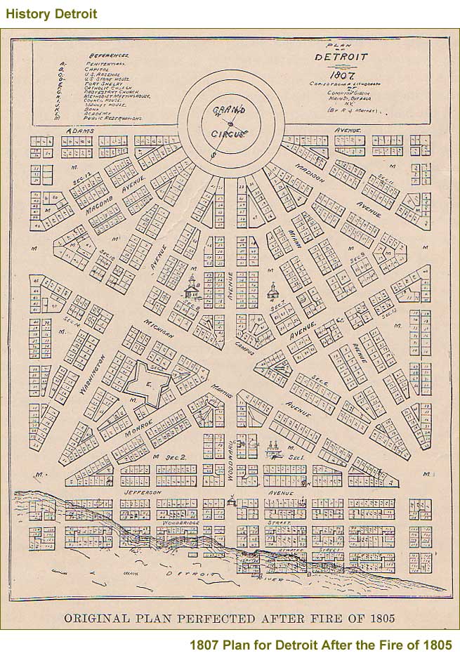
 Augustus Woodward's plan following the 1805 fire for Detroit's baroque styled radial avenues and Grand Circus Park.
Following a historic fire in 1805, Justice Augustus B. Woodward devised a plan similar to Pierre Charles L'Enfant's design for Washington, D.C. Detroit's monumental avenues and traffic circles fan out in a baroque styled radial fashion from Grand Circus Park in the heart of the city's theater district, which facilitates traffic patterns along the city's tree-lined boulevards and parks.[4] The 'Woodward plan' proposed a system of hexagonal street blocks, with the Grand Circus at its center. Wide avenues, alternatively 200 feet (61 m) and 120 feet (37 m), would emanate from large circular plazas like spokes from the hub of a wheel. As the city grew these would spread in all directions from the banks of the Detroit River. When Woodward presented his proposal, Detroit had fewer than 1,000 residents. Elements of the plan were implemented. Most prominent of these are the five main "spokes" of Woodward, Michigan, Gratiot, Grand River and Jefferson Avenues.
The Mile Road System in Metro Detroit and Southeast Michigan facilitates ease of navigation in the region. It was established as a way to delineate east–west roads through the Detroit area and the surrounding rural rim. The Mile Road system, and its most famous road, 8 Mile Road, came about largely as a result of the Land Ordinance of 1785, which established the basis for the Public Land Survey System in which land throughout the Northwest Territory was surveyed and divided into survey townships by reference to a baseline (east–west line) and meridian (north–south line). In Southeast Michigan, many roads would be developed parallel to the base line and the meridian, and many of the east–west roads would be incorporated into the Mile Road System.
The Mile Road System extended easterly into Detroit, but is interrupted, because much of Detroit's early settlements and farms were based on early French land grants that were aligned northwest-to-southeast with frontage along the Detroit River and on later development along roads running into downtown Detroit in a star pattern, such as Woodward, Jefferson, Grand River, Gratiot, and Michigan Avenues, developed by Augustus Woodward in imitation of Washington, D.C.'s system. As Detroit grew, several Mile Roads were given new names within the city borders, while some roads incorporated as part of the Mile Road System have traditionally been known by their non-mile names. It is unclear if they ever bore mile numbers formally.
The baseline used in the survey of Michigan lands runs along 8 Mile Road, which is approximately eight miles directly north of the junction of Woodward Avenue and Michigan Avenue in downtown Detroit. As a result, the direct east–west portion of Michigan Avenue, and M-153 (Ford Road) west of Wyoming Avenue, forms the "zero mile" baseline for this mile road system.
The precise point of origin is located in Campus Martius Park, marked by a medallion[5] embedded in the stone walkway. It is situated in the western point of the diamond surrounding Woodward Fountain,[6] just in front of the Fountain Bistro.
Freeways
 Map of Detroit Metro Area freeways
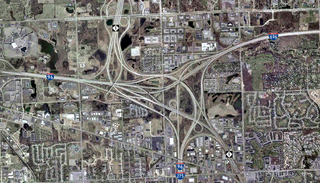

I-75 (known as the Walter P. Chrysler Freeway from Downtown Detroit to Pontiac in the north and Fisher Freeway though southern and central Detroit) is the region's main north-south route, serving Flint, Pontiac, Troy, and Detroit, before continuing south (as the Detroit-Toledo and Seaway Freeways) to serve many of the communities along the shore of Lake Erie,most notably Toledo, Ohio. 
I-94 (Edsel Ford Freeway & Detroit Industrial Expressway) runs east-west through Detroit and serves Ann Arbor to the west (where it continues to Chicago) and Port Huron to the northeast. The stretch of the current I-94 freeway from Ypsilanti to Detroit was one of America's earlier limited-access highways. Henry Ford built it to link his factories at Willow Run and Dearborn during World War II. It also serves the North Access to the Detroit Metro Airport in Romulus. A portion was known as the Willow Run Expressway. 
I-96 runs northwest-southeast through Livingston, Oakland and Wayne counties and has its eastern terminus in downtown Detroit. Originally named the Jeffries Freeway in Wayne County, the portion between the Fisher and the Ford was renamed by the state legislature to the Rosa Parks Memorial Highway in December 2005.[7] 
I-275 runs north-south from I-75 in the south to the junction of I-96 and I-696 in the north, providing a bypass through the western suburbs of Detroit. 
I-375 is a short spur route in downtown Detroit, an extension of the Chrysler Freeway. 
I-696 (Walter P. Reuther Freeway) runs east-west from the junction of I-96 and I-275, providing a route through the northern suburbs of Detroit. Taken together, I-275 and I-696 form a semicircle around Detroit. 
M-5 This freeway begins as the stub leftover from the Brighton-Farmington Expressway after Interstate 96 was rerouted to the Jeffries. From 1994 to 2002, it was extended north as the Haggerty Connector.[8] 
M-8 is the Davison Freeway. Opened in 1942, this was the first modern depressed limited-access freeway in America. 
M-10: The John C. Lodge Freeway runs largely parallel to I-75 from Southfield to downtown. 
M-14 runs east-west from I-275 in Livonia to Ann Arbor. 
M-39: The Southfield Freeway runs north-south from Southfield to Allen Park from I-94. North of 10 Mile Road, the freeway ends and continues as Southfield Road into Birmingham. 
M-53 (Christopher Columbus Freeway from Sterling Heights to Washington), more commonly known as the Van Dyke Expressway or Van Dyke Freeway. Continues as Van Dyke Road or Van Dyke Avenue north to Port Austin and south through Warren to Gratiot Avenue in Detroit. 
M-59 (Veterans Memorial Freeway from Utica to Pontiac), continues east as Hall Road to Clinton Township and west as Huron Road through Pontiac and Waterford, and as Highland Road further west through Highland and Milford to I-96 near Howell Other selected major roads
- 8 Mile Road, known by many due to the film 8 Mile, forms the dividing line between Detroit on the south and the suburbs of Macomb and Oakland counties on the north. It is also known as Baseline Road outside of Detroit, because it coincides with the baseline used in surveying Michigan; that baseline is also the boundary for a number of Michigan counties. It is designated as M-102 for much of its length in Wayne County.
- Gratiot Avenue (M-3) is a major road that runs from Marysville to downtown Detroit.
- Jefferson Avenue is a scenic highway that runs parallel to the shore of the Detroit River and Lake St. Clair. It is also the principal thoroughfare for the Grosse Pointes, where it is called Lake Shore Drive. Another important dividing line between Detroit and the city of Grosse Pointe Park is Alter Road, where portions of some intersecting streets have been reconfigured or walled-off in order to thwart vehicular and pedestrian movement from Detroit into Grosse Pointe Park.
- Michigan Avenue/US 12 runs from downtown Detroit through the western suburbs toward Ypsilanti, passes south of Ann Arbor, and eventually reaches Chicago.
- Woodward Avenue (M-1) is considered the Detroit area's main thoroughfare. It is the dividing line between the East Side and the West Side. Woodward stretches from downtown Pontiac to the Detroit River near Hart Plaza. In Downtown Detroit, the Fox Theatre and Detroit Institute of Arts are located on Woodward as well as the Detroit Zoo just outside of the city. The Woodward Dream Cruise, a classic car cruise from Pontiac to Ferndale is held in August and is the largest single day classic car cruise in America.
- Telegraph Road (US 24) is a major north-south road extending from Toledo, Ohio through Monroe, Wayne, and Oakland Counties to Pontiac. It has gained notoriety in a song (Telegraph Road) by the group Dire Straits.
- Dixie Highway or (Dix-Toledo) is one of America's historic highways. Its eastern division extended from Miami, FL to Sault Ste. Marie, MI. The remnants of this highway exist northbound and southbound through the Detroit metropolitan area.
- Fort Street (M-85) is the only Michigan highway in Downriver. It extends from Flat Rock to Detroit.
- Grand River Avenue connects the suburbs of Brighton, Novi, and Farmington to downtown Detroit. It is one of the five roads planned by Judge Augustus Woodward to radiate out from Detroit and connect the city to other parts of the state. It extends out to Lansing and in East Lansing is the main road and the dividing line between the city of East Lansing and the campus of Michigan State University.
Mile roads traveling north
Mile roads within Wayne County
The mile roads that cross through Wayne County are designated as follows:
- 0 Mile - Michigan Avenue in Detroit; Ford Road west of Detroit, though Ford Road does straddle the Detroit city limits for some blocks. Michigan Avenue is slightly north of Ford Road. Occupied by Cadillac Square east of Campus Martius.
- 1 Mile - Warren Avenue (turns east-northeastward at 25th Street in Detroit to conform with the Woodward plan). Western county line to Mack Avenue on the Detroit/Grosse Pointe Farms limits. Deviates off-grid to the south between just east of Lilley Road in Canton to Cowan Road in Westland. From the east, for a half-mile east of the western county line, it is not paved.
- 2 Mile - Joy Road (also turns east-northeastward (at Livernois), but for a shorter distance). Western county line to Linwood Street in Detroit. Interrupted twice, first between Hines Drive and Wayne Road on the Westland/Livonia border and again just before the western county line, where it's gridline is occupied by Ann Arbor Road.
- 3 Mile - Plymouth Road. Mill Street in Plymouth (here it continues westward as Main Street) to Grand River Avenue near Oakman Boulevard in Detroit. Runs off-grid west of the Ann Arbor Road split in Livonia.
- 4 Mile - Schoolcraft Avenue (Detroit); Schoolcraft Road (now the service drive for I-96). 5 Mile Road in Plymouth to Ewald Circle in Detroit.
Note that the 0-4 Mile roads are not signed and never referred to as Mile Roads; it remains unclear if they were ever signed as Mile Roads. There is a Three Mile Drive in the far eastern portion of Detroit and going into Grosse Pointe Park, but it is unclear if this was ever intended to be a part of the Mile Road System.
- 5 Mile - Fenkell Street (Detroit); 5 Mile Road (west of Detroit). Western county line to Rosa Parks Boulevard in Detroit.
- 6 Mile - McNichols Street (Detroit); 6 Mile Road (west of Detroit). Western county line to Gratiot Avenue in Detroit.
- 7 Mile - 7 Mile Road (Detroit and west of Detroit). Western county line to Kelly Road in Detroit.
- 8 Mile - 8 Mile Road (Detroit and suburbs); Base Line Road (west of Detroit); also signed as M-102 from Grand River Avenue to Vernier Road.

Note: On Detroit's far east side, which is aligned according to the French colonial long lot system rather than the Northwest Ordinance survey grid, Cadieux, Moross, and Vernier Roads are not extensions of 6 Mile Road, 7 Mile Road and 8 Mile Road, respectively. East McNichols (6 Mile) ends at Gratiot Avenue, with traffic continuing to Cadieux two miles (3 km) away via Seymour Street and Morang Drive. East 7 Mile Road ends as a short four-lane one-way side street at Kelly Road, two blocks east of where Moross veers off from 7 Mile, taking most traffic with it. Most traffic on 8 Mile Road continuing east of Kelly Road veers onto Vernier Road; 8 Mile continues as a side street eastward for a short distance past Harper Avenue. This is a common misconception by residents of Detroit, Harper Woods and Grosse Pointe, as Cadieux, Moross and Vernier appear to be extensions of their mile-road neighbors, but are in fact roads in their own right.
In the city of Detroit, residents only refer to 3 of the mile roads; 6, 7, & 8 Mile. 6 Mile Road is signed as "McNichols" throughout the city of Detroit, but is often referred to as "6 Mile" by residents. 5 Mile road, on the other hand, is almost always referred to as "Fenkell" (which is how it is signed in Detroit), and only very rarely as "5 Mile". The dual naming of McNichols is an occasional source of confusion to out-of-town travelers.
Although not signed as such, Detroit also has roads along half-mile gridlines:
- 1⁄2 Mile - Paul Street (Dearborn and Detroit), Ann Arbor Trail (for a short distance), Hass Avenue (Dearborn Heights), Maplewood Avenue (Garden City), Hunter Street (Westland), Hanford Road (Canton)
- 11⁄2 Mile - Tireman Avenue (Detroit (there turns east-northeastward), Dearborn and Dearborn Heights), Ann Arbor Trail (also for a short distance), Gyde Road (Canton)
- 21⁄2 Mile - Chicago Avenue, Chicago Street (once again, turns east-northeastward)
- 31⁄2 Mile - Fullerton Avenue (once again, turns east-northeastward)
- 41⁄2 Mile - Lyndon Avenue
- 51⁄2 Mile - Puritan Avenue, Puritan Street (once again, turns east-northeastward)
- 61⁄2 Mile - Curtis Street (west of Woodward), Nevada Street (east of Woodward)
- 71⁄2 Mile - Pembroke Avenue; also Outer Drive and State Fair east of Woodward Avenue.
Mile roads within Washtenaw County
Much like Livingston County, very few mile roads extend west into Washtenaw County.
- 0 Mile (M-153) - Ford Road - Runs off the grid to meet M-14. This is the only portion of Ford Road within Washtenaw County that is paved.
- 0 Mile (West of M-153) - Ford Road - West to Earhart Road, interrupted between Plymouth and Dixboro roads.
- 1 Mile - Warren Road - Eastern county line west to Whitmore Lake Road, interrupted between Berry and Curtis Roads due to M-14. Paved for a short distance west of Curtis Road.
- 2 Mile - Joy Road - Eastern county line west to Mast Road and Dexter. Runs off the grid west of Whitmore Lake Road.
- 5 Mile - Eastern county line west to a dead end west of Whitmore Lake Road, interrupted between Spencer and Nollar Roads.
- 6 Mile - Eastern county line west to Whitmore Lake Road, interrupted between Spencer and Nollar Roads , where it falls off the grid westward.
- 7 Mile - Eastern county line west to Shore Drive near Whitmore Lake. T's with Tower Road and then resumes off the grid.
- 8 Mile (Eastern Section) - Eastern county line west to Spencer Road near Whitmore Lake
- 8 Mile (Western Section) - US 23 (Exit 53) to Hall Road
Mile roads within Livingston County
Few of the mile roads continue west into Livingston County.
- 8 Mile Road
- 9 Mile - Eastern county line west to Spicer Road. Signed as M-36 from US 23 to Spicer Road. Does not follow a straight east–west route west of US 23.
- 10 Mile - Eastern county line west to Rushton Road.
- 12 Mile - Eastern county line west to Rushton Road.
Mile roads within Oakland County
The mile roads in the southernmost part of Oakland County are known only by their numbers. From 15 Mile Road northward, however, all mile roads have local names, sometimes several. And like Macomb County and Detroit, some roads are placed at half-mile intervals.
- 8 Mile Road
- 81⁄2 Mile Road - Northend Avenue (only within Oak Park and Royal Oak Township)
- 9 Mile Road
- 91⁄2 Mile Road - Mount Vernon Street (Southfield), Oak Park Boulevard (Oak Park), Woodward Heights Boulevard (Ferndale, Hazel Park)
- 10 Mile Road - Lake Street (through South Lyon), service drive for I-696 from approximately Coolidge Highway to Dequindre Road.
- 101⁄2 Mile Road - Lincoln Avenue, Civic Center Drive (Southfield)
- 11 Mile Road - service drive for I-696 from approximately Greenfield Road to M-10.
- 111⁄2 Mile Road - Gardenia Avenue, Catalpa Drive, Saratoga Boulevard, Winchester Street
- 12 Mile Road
- 121⁄2 Mile Road - Webster Road
- 13 Mile Road
- 131⁄2 Mile Road - Whitcomb Avenue, Normandy Road, Beverly Road
- 14 Mile Road
- 141⁄2 Mile Road - Elmwood Avenue, Lincoln Street
- 15 Mile Road - Maple Road
- 16 Mile Road - see below
- 161⁄2 Mile Road - Lone Pine Road
- 17 Mile Road - Wattles Road
- 171⁄2 Mile Road - Long Lake Road (west of Woodward)
- 18 Mile Road - Long Lake Road (east of Woodward)
- 181⁄2 Mile Road - Westview Road, Hickory Grove Road
- 19 Mile Road - Square Lake Road
- 20 Mile Road - South Boulevard
- 21 Mile Road - Auburn Road
- 22 Mile Road - Hamlin Road, Featherstone Road/Street
- 23 Mile Road - Avon Road
- 24 Mile Road - Hatchery Road, Walton Boulevard, University Drive in downtown Rochester, Parkdale Road East of downtown Rochester
- 25 Mile Road - Williams Lake Road, Walton Boulevard (for a short distance before deviating a mile south), Runyon Road, Tienken Road (end of the Official Metro-Detroit designation, though disputed)
- 26 Mile Road - Mead Road, Dutton Road, Brown Road, Mann Road
- 27 Mile Road - Silver Bell Road, Maybee Road
- 271⁄2 Mile Road - Snell Road
- 28 Mile Road - Waldon Road, Gunn Road
- 29 Mile Road - Buell Road
- 30 Mile Road - Stoney Creek Road, Clarkston Road
- 31 Mile Road - Predmore Road
- 32 Mile Road - Romeo Road
- 33 Mile Road - Brewer Road, Drahner Road
- 34 Mile Road - Mack Road, Lakeville Road
- 35 Mile Road - Frick Road
- 36 Mile Road - Noble Road
- 37 Mile Road - Oakwood Road
- 38 Mile Road - Davison Lake Road
Mile roads within Macomb County
Through Macomb County, most of these road names are not carried over, and nearly all of the Mile Roads are known by their mile numbers. One notable exception is Hall Road, which is part of M-59 and almost never referred to as 20 Mile Road. 16 Mile Road is never referred to that either as it is known as Metropolitan Parkway in Macomb County.
Note: there were some roads listed as xx-half Mile Roads, and placed in between the roads, such as 13 Mile Road, 131⁄2 Mile Road, 14 Mile Road, in that succession for example. Some are signed as such.
- 8 Mile Road
- 8½ Mile Road - Toepfer Road
- 9 Mile Road
- 9½ Mile Road - Stephens Road and Woodward Heights
- 10 Mile Road - I-696 Service Drive from roughly Dequindre Road to roughly Coolidge Highway
- 10½ Mile Road - Frazho Road and Lincoln Avenue
- 11 Mile Road - I-696 Service Drive from I-94 to roughly Dequindre Road)
- 11½ Mile Road - Martin Road (Called "Tank Avenue" for part of its length running through the old Arsenal property between Van Dyke and Mound)
- 12 Mile Road
- 12½ Mile Road - Common Road
- 13 Mile Road (partly diverted to become Chicago Road. Old alignment is now Old 13 Mile Road, from Van Dyke Road to Chicago Road/13 Mile intersection)
- 13½ Mile Road - Masonic Boulevard
- 14 Mile Road
- 14½ Mile Road - Quinn Road (only exists east of Gratiot), Cottrell Road (exists east of Harper, turns east-southeast)
- 15 Mile Road - Maple Road (Oakland County)
- 15½ Mile Road - Brougham Drive, Glenwood Road (between Gratiot Ave/M-3 and Harper Ave)
- 16 Mile Road (See notes on 16 Mile Road, below)
- 16½ Mile Road (between Van Dyke Road and Dodge Park Road)
- 17 Mile Road (has been carved up and re-aligned in some parts to fit in with newer suburbs as they were built in the 1970s and 1980s)
- 18 Mile Road
- 18½ Mile Road (between Van Dyke Road and Ryan Road only)
- 19 Mile Road
- 19½ Mile Road (within Utica, MI only)
- 20 Mile Road (See notes above for 20-24 Mile Roads in Macomb County)
- 21 Mile Road
- 22 Mile Road
- 23 Mile Road - Part of M-29 east of I-94 towards New Baltimore
- 24 Mile Road - French Road (brief segment just E of Dequindre)
- 25 Mile Road
- 26 Mile Road - Marine City Highway east of I-94
- 27 Mile Road - Clark Road (within New Haven, MI)
- 28 Mile Road
- 29 Mile Road
- 30 Mile Road
- 31 Mile Road - St. Clair Highway (from Richmond, MI east all the way to the east Michigan water border)
- 32 Mile Road - Division Road(within Richmond, MI), St. Clair Road (within Romeo, MI)
- 33 Mile Road - Clay Road
- 34 Mile Road - Woodbeck Road
- 35 Mile Road - Schoof Road
- 36 Mile Road - Dewey Road
- 37 Mile Road - McPhall Road
Mile roads within St. Clair County
Through St. Clair County, most of these mile number names are not carried over, and nearly all of the Mile Roads are known by their road names.
- 25 Mile Road - Arnold Road
- 26 Mile Road - Marine City Highway
- 27 Mile Road - Springborn Road
- 28 Mile Road - Meisner Road
- 29 Mile Road - Lindsey Road
- 30 Mile Road - Puttygut Road
- 31 Mile Road - St. Clair Highway
- 32 Mile Road - Division Road (Richmond, MI to Palms Rd.), Fred W Moore Highway (Palms Rd.to St. Clair, MI)
- 33 Mile Road - Clay Road
- 34 Mile Road - Woodbeck Road, Big Hand Road
- 35 Mile Road - Crawford Road
- 36 Mile Road - Meskill Road
- 37 Mile Road - Frith Road
Mile roads within Lapeer County
The system continues uninterrupted in sequence up to 38 Mile Road, on the Macomb County / Lapeer County boundary near Almont, MI and Van Dyke Road (M-53). However, although not signed as mile roads, major roads still lie at one-mile (1.6 km) intervals for several miles into Lapeer County.
- 38 Mile Road - Bordman Road/Davison Lake Road
- 39 Mile Road - Hough Road
- 40 Mile Road - Almont Road, St. Clair Street, General Squier Road
- 41 Mile Road - Tubspring Road
- 42 Mile Road - Dryden Road
- 43 Mile Road - Hollow Corners Road
- 44 Mile Road - Webster Road, Ross Road, Sutton Road
- 45 Mile Road - Hunters Creek Road
- 46 Mile Road - Newark Road
- 47 Mile Road - Belle River Road
- 48 Mile Road - Attica Road
- 49 Mile Road - Imlay City Road (W of Van Dyke); Weyers Road (E of Van Dyke)
- 50 Mile Road - Bowers Road
8 Mile Road
Main article: 8 Mile RoadLocally, 8 Mile Road is considered the political and social dividing line between the city of Detroit and its northern suburbs. (It marks most of the northern boundary of both Detroit and Wayne County.) In 2002 this local notoriety was promoted to international attention, reflected in the name of Eminem's acclaimed film, 8 Mile.
16 Mile Road
The alignment for 16 Mile Road through Oakland and Macomb Counties is composed of four named roads:
- Walnut Lake Road (through West Bloomfield Township)
- Quarton Road (from Inkster Road to Woodward Avenue)
- Big Beaver Road (from Woodward to Dequindre)
- Metropolitan Parkway (from Dequindre to Metro Beach Metropark)
Walnut Lake Road turns slightly southward in West Bloomfield and runs parallel to Quarton Road .5 miles (0.80 km) to the south, between Inkster and Franklin Roads. West and East Quarton Roads are disconnected slightly by Telegraph Road due to Gilbert Lake.
Addresses
With a few exceptions, one can determine which mile roads an address is between on major north–south roads north of Five Mile/Fenkell by using the formula:
- [(first two numbers of the address)-5] / 2
- Example: 34879 Gratiot Avenue [(34-5)/2] = 14.5 which indicates the address is between 14 and 15 Mile Road.
In the early days of addresses in the area, surveyors calculated position on the grid of mile roads to define addresses. The resulting system, sometimes referred to as the Detroit Edison system, generally assigns 2000 addresses to each mile. (There are often gaps in the numbering; for instance, East addresses 9000 to 10999 are skipped). Addresses in the Detroit area tend to be much higher than in other large cities, with numbers in the 20000's common within the city limits and in the inner-ring suburbs. Typically, addresses of single family homes on adjacent lots on the grid system, both within Detroit and in the suburbs, are incremented by 8, 10, 12 or more rather than by 2 as is the case in most other large cities in the United States.
The highest addresses used in the Detroit system are the range 79000 to 80999, for north–south roads beyond 37 Mile Road in northern Macomb County, and from 81000 to the high 81900’s in the portion of the city of Memphis, MI that bulges ~0.5-mile (0.80 km) into St. Clair County. For many years, the Guinness Book of Records incorrectly listed 81951 Main St (aka M-19) in Memphis as the highest street address number anywhere, but much higher numbers appear in Topaz, CA, Key Largo, FL, and Grey County, Ontario addresses.
Mile roads traveling south
The grid continues south of Ford Road, although not numbered as part of the Mile Road System. None of these roads connect to Detroit. Further south and west, and along Downriver, the roads tend to fall off the grids more often, for several reasons, including their closeness to the state of Ohio and natural features preventing straight road building.
- Ford Road - Zero Mile Road
- Saltz Road - South 0½ Mile, Saltz Road west of I-275, Marquette Avenue/Road east of I-275 to Inkster Road, Wilson Drive east of Inkster Road.
- Cherry Hill - South 1 Mile, Dixboro to Dearborn.
- Avondale Street - South 1½ Mile, Dearborn Heights to Westland.
- Palmer Road - South 2 Mile, Canton Township to Westland-Inkster border. Vreeland Road in Washtenaw County
- Glenwood Road - South 2½ Mile (only within Wayne and Westland, Michigan)
- Geddes Road - South 3 Mile, Superior Township to Canton Township. Carlysle Road in Inkster and Dearborn.
- Annapolis Road - South 31⁄2 Mile, Wayne to Dearborn Heights (1/2 mile gap in Westland)
- Van Born Road - South 4 Mile, township border road, from Van Buren Township to Allen Park, where it ends at a trumpet interchange with M-39 and its service drives. On the north, it borders Canton, Wayne, Westland and Dearborn Heights. On the south it borders Van Buren Township, Romulus, Taylor and Allen Park. Just before Lilly Road it falls off grid due to the Norfolk Southern Railway Michigan Line, which at this point is used also by Amtrak's Wolverine service.
- Beverly Road - South 4½ Mile (only within Romulus and Taylor)
- Ecorse Road - South 5 Mile, former M-17. Once a major artery to the Willow Run Expressway. West of US-12 in Washtenaw County almost migrates a mile.
- Champaign Street/Road - South 5½ Mile, Taylor to Lincoln Park (side street for its entire length)
- Wick Road/Hartwick Highway - South 6 Mile, Romulus to Lincoln Park, divided side street in Allen Park. Ends at Vine Avenue and resumes as Hartwick Highway (despite its name is a residential street), merging with Minnie Street at Bailey Avenue and falls off grid. East of I-75 it is almost followed by the residential Progress Avenue for three blocks.
- Hildebrandt/Kinyon- South 6½ Mile - Hildebrandt Street in Romulus, starting at Middlebelt Road which runs along the boundary of the Detroit Metro Airport, ends a mile after, Kinyon Street takes over in Taylor, but is a residential street and is interrupted a couple times. Midway Avenue in Allen Park also follows it twice. It is also followed by Buckingham Avenue in Lincoln Park.
- Goddard Road - South 7 Mile, Romulus to Wyandotte, falls off grid just east of I-75 but has no exit. Moran Avenue takes over to River Drive while Goddard runs jagged to Biddle Avenue in Wyandotte.
- Brest Road - South 7½ Mile - 2nd Street in Wyandotte to Inkster Road in Taylor. Has a few interruptions. Brest Road (west of Wyandotte); Baumey Avenue (Wyandotte)
- Northline - South 8 Mile - Northline Road (west of Wyandotte); Ford Avenue (Wyandotte). Interrupted by the Metro Airport, then west of there, meanders northwest with Wabash Street taking over just west of the CSX Transportation crossing, ends at Hannan Road and become a service drive for I-94.
- Superior - South 8½ Mile - Superior Street/Boulevard (west of Wyandotte); Vinewood Avenue (Wyandotte)
- Eureka Road - South 9 Mile, forms southern boundary of Detroit Metropolitan Airport. Recently improved from I-275 to handle increased airport traffic.
- Leroy Street - South 9½ Mile - Leroy Street (west of Wyandotte); Grove Street (Wyandotte)
- Pennsylvania - South 10 Mile, township border road. Borders Wyandotte, Southgate, Taylor and Romulus on the north side and Riverview, Brownstown Township and Huron Township to the south.
- Prescott - South 10½ Mile - Prescott (Huron Township); Crawford (Brownstown Township); Longsdorf Street (Riverview). Is interrupted near its western end by the Pinnacle Race Course
- Sibley Road - South 11 Mile, Jefferson on the Riverview/Trenton limits to Huron River Drive in New Boston.
- Bredow Road/Avenue - South 11½ Mile
- King Road - South 12 Mile, Jefferson in Trenton to Vining Road in Huron Township.
- Carter Road - South 12½ Mile - Carter (west of Trenton); Harrison Avenue (Trenton)
- Huron Road / West Road - South 13 Mile - Huron (west of I-275); West (east of I-275)
- Grix Road - South 13½ Mile - Grix/Stacey/Provincal/Marian in Huron Township, Brownstown Township, Woodhaven and Trenton, respectively.
- Van Horn - South 14 Mile, Willow Metropark to Trenton.
- Vreeland - South 15 Mile, city limit road, with Woodhaven and Trenton on the north side and Flat Rock, Brownstown Township and Gibraltar on the south side. Recently extended west of Telegraph Road and at the Telegraph Road intersection mast-arm traffic lights have been installed.
- Will Carleton Road / Gibraltar Road - South 16 Mile (border of Wayne and Monroe County)
- Woodruff Road - South 17 Mile, H.R. Drive in Flat Rock to Jefferson in Gibraltar
- Carleton-Rockwood Road / Huron River Drive - South 18 Mile
- Ready Road / Lee Road - South 19 Mile
- Sigler Road - South 20 Mile
- Labo Road - South 21 Mile
- Newport Road - South 22 Mile
- Buhl Road - South 23 Mile
- Post Road / Stumpier Road - South 24 Mile
In Wyandotte, residents refer to the names of Goddard, Northline, Eureka and Pennsylvania. Northline is signed as "Ford" throughout the city, but is referred by residents as "Northline". Northline's dual naming in Wyandotte is a likely source of confusion for out-of-town visitors.
The north–south mile grid
There are many roads through Wayne, Oakland, Macomb and even Monroe counties that parallel the Michigan Meridian, creating a grid-type system. Like the east–west Mile Road System, the north–south grid roads lose cohesion to the grid in much of Detroit, and in the lake-filled areas of Oakland County.
Proceeding west from Lake St. Clair:
- Greater Mack Ave - Residential street, cuts off several times between 10 and 15 Mile before becoming a steady street. Mack Avenue in Detroit.
- Little Mack Ave - Approximately 9-16 Mile, cutting off once at 14 Mile. Gridline taken by Heydenreich Road in the northern suburbs.
- Kelly Road and Romeo Plank Road (Between Clinton River Road and roughly 24 Mile Road) Becomes diagonal at 9 Mile and remains that way to Hayes Street in Detroit.
- Garfield Road - From Utica Road in Fraser to 22 Mile Road in Macomb Township.
- [Hayes Road] - Although not fully contiguous, Hayes Road is a township border road through eastern Macomb County. Terminates at 28 Mile. Also continues south of 8 Mile in Detroit as Hayes Street to the large intersection of Harper, Chalmers and Hayes just near I-94.
- Schoenherr Road - An example of a gridline road with a divided highway portion. Paved between southern terminus and 26 Mile Road. Terminates at 29 Mile.
- Hoover Road, Dodge Park Road, (Chicago Road and Maple Lane Drive connect Hoover and Dodge Park from just south of 14 Mile to 15 Mile), M-53 Freeway, and Jewell Road. These series of roads follow the same grid line until about 29 Mile Road when Van Dyke Avenue takes over.
- Van Dyke Avenue M-53 (Van Dyke Avenue) Runs from Jefferson Avenue in Detroit past 18 Mile Road in Sterling Heights. Although M-53 ends at Gratiot Avenue in Detroit, Van Dyke Avenue itself actually continues to Jefferson Avenue in Detroit, adjacent to the Detroit River. At 18-Mile Road in Sterling Heights, M-53 splits off towards the East into a freeway, and the grid road (old M-53) continues northward as the Van Dyke Road (also signed in some places as the Earle Memorial Highway). South of 28 Mile Road, Van Dyke begins a NorthEast shift to a mile eastward and Camp Ground Road takes over to continue the Grid. Van Dyke Ends in Port Austin, MI.
- Mound Road - Originally planned to be at least partially a freeway, connecting the Davison Freeway with I-696 and the M-53 Freeway, hence the massive stacked interchange at I-696.
- Ryan Road - Runs from 23 Mile in Shelby Township through Sterling Heights, Warren and into Detroit before falling off the grid at McNichols.
- Dequindre Road - The borderline between Oakland and Macomb Counties. Not fully contiguous, falling off the grid briefly at 26 Mile before resuming just north of 28 Mile.
- John R Road - Begins at Bloomer Park in Rochester just north of 23 Mile (Avon Rd.) and continues south to McNichols. Past that it turns to run parallel with Woodward to downtown Detroit.
- Stephenson Highway - Branches off of Rochester Road south of the Troy I-75 Interchange. Rochester turns west before turning back south and running parallel with Stephenson. Stephenson becomes the service drive for I-75 at 12 Mile.
- Campbell Road - Begins at 14-Mile. Runs parallel to Stephenson Highway and Rochester Road. Continues past the I-696 exit as Hilton Road in Ferndale. North of I-696/10 Mile, the road runs in Royal Oak and Madison Heights, and it serves as the border between the two cities for most of the stretch.
- Rochester Road (north of Troy I-75 interchange). Known as Main Street in downtown Rochester. Splits off to Stevenson Highway and turns west for a short path until it turns back parallel with Stevenson. It continues down into Royal Oak, where it ends at the Main-Crooks-Rochester interchange. Ends in Lapeer County on the Northern end. Carries the M-150 state highway designation through Rochester Hills.
- Livernois Road - Broken between Ferndale and Royal Oak, due in part to Pleasant Ridge not allowing the road through 1920s and the massive I-696/Woodward interchange. Livernois is known as Main Street in Royal Oak and Clawson. Southward, it extends past Joy Road before turning to run parallel with Woodward to Jefferson. Northward, it ends in Rochester, at 26 Mile (Dutton) as a dirt road.
- Dix Road - Begins at Oakwood Boulevard in Melvindale, runs along the Greenfield Road line through Lincoln Park, Southgate, and then becomes diagonal again and continue even further as Toledo Road
- Allen Road - Beginning at an off-grid Greenfield in the same city that Dix starts in, Allen also continues south through Allen Park and at Goddard Road runs along the Evergreen/Cranbrook line as a city limit road with Taylor to the west and Southgate through the east, then going through Brownstown Township and Woodhaven before running parallel with Fort Street to a T with Gibraltar Road.
- Wyoming Avenue, Crooks Road, Old Perch Road, Lake George Road - Although disconnected by several miles, these four roads lie along the same grid alignment. Wyoming is the easternmost north–south grid road to reach the Zero Mile road (Ford Road) on the same north–south alignment. 5th Street in Wyandotte follows this grid.
- Schaefer Highway (south of 8 Mile Road), Coolidge Highway (north of 8 Mile Road). Prior to Detroit's annexation of Greenfield Township, Schaefer Highway was known as Monnier Road. 19th, Krause and Roehrig streets follow this line in Wyandotte, Riverview and Trenton respectively.
- Greenfield Road - Township border road. Formed the border of former Greenfield Township and Redford Township, now parts of Detroit. Begins in Dearborn and runs north to end at 14 Mile Road. Dix and Trenton roads follow this line in Southgate and this line is followed by Gorno Street in Trenton.
- Adams Road - Begins at Woodward (just south of Lincoln = 141⁄2 Mile) and runs north along the line set by Greenfield Road About 1/3 mile north of Auburn Road (21 Mile), Adams swings about a mile east, then runs north roughly along the Schaefer/Coolidge line to end at Stoney Creek Road (301⁄2 Mile)
- Squirrel Road - Unusual for not following exactly the mile grid lines, Squirrel runs north from Wattles Road (17 Mile) along a north–south line displaced ~1/4 mi E from the line of Southfield Road Squirrel then drifts further east before ending at Silver Bell Road (27 Mile Road).
- Southfield Road - M-39, a limited-access freeway with service drive for much of its length from Allen Park north into Southfield. Beyond 9 Mile Road, Southfield Road is a surface street, running north to end at Maple Road (15 Mile). Park Avenue in Allen Park and Churchill Street in Southgate follow this line.
- Evergreen Road (south of 13 Mile Road), Cranbrook Road (13 Mile Road to just north of Maple, then Covington Road until end at Quarton Road) Pelham and Allen roads follow Evergreen's grid from Dearborn to Gibraltar Road near Fort Street.
- Opdyke Road - Follows Evergreen's grid. Runs north from Woodward just north of Long Lake Road (which at that point is roughly 171⁄2 Mile), then drifts further east before dumping into M-24 (Lapeer Road) just north of Walton Boulevard (24 Mile). Opdyke is pronounced by the locals as “UP-dike”.
- Lahser Road - The center road for old Redford Township (now part of Detroit), Lahser connects with Outer Drive south of 5 Mile Road and runs north to end at Square Lake Road (19 Mile). The name Lahser is often mispronounced, most often because of careless misreading as “Lasher”. Another common but deprecated pronunciation is “LAH-zer”. Students of Lahser High School in Bloomfield Township are quick to assert “LAH - sir” as the correct pronunciation, but many older Detroiters are equally insistent on “LAH - sher” (rhymes with ‘nosher’). Monroe and Racho roads follow Lahser's grid, in a discontinuous fashion, from southern Dearborn to Brownstown Township.
- Telegraph Road - US 24 follows the grid alignment from Brownstown Township to Southfield, where it strays slightly off the gridlines. Telegraph forms much of the western boundary of Detroit. The second Single-Point Urban Interchange in metro Detroit opened at Telegraph and I-94. Recently improved in Taylor with new pavement and 1950's suburban streetlights installed.
- Beech Daly Road - simply Beech Road between 8 Mile and 10 Mile, where it ends; Franklin Road in Oakland County roughly corresponds to this alignment north of 11 Mile Road
- Inkster Road - Township border road; separates several communities, including Farmington Hills and Southfield in Oakland County, and Redford Township and Livonia in Wayne County. Runs through the city of Inkster.
- Middlebelt Road - sometimes incorrectly signed as "Middle Belt Road"
- Merriman Road (south of 8 Mile Road), Orchard Lake Road (north of 8 Mile Road) - At its south end, Merriman leads into the Detroit Metropolitan Airport, and becomes John D. Dingell Drive It resumes its grid position south of the airport.
- Farmington Road - Major road north of E.N. Hines Drive, and exists as a small, residential road through Westland and Garden City. Venoy Road serves as the major artery although at a grid position 1/4 mile east of Farmington from Hines Park south to Van Born. Vining Road resumes Farmington Road's position south of Metro Airport.
- Drake Road (north of 9 Mile Road), Wayne Road (south of Plymouth Road)
- Newburgh Road (south of 8 Mile Road), Halsted Road (north of 8 Mile Road)
- Haggerty Road - A township border road between Pontiac Trail and 6 Mile Road, Haggerty significantly deviates westward south of 6 Mile, migrating to an alignment one mile (1.6 km) west within Canton Township. Other roads that follow the border alignment include Eckles Road, Hannan Road, Clark Road, and, in Monroe County, Exeter Road.
- Meadowbrook Road, Welch Road - Separated between 13 and 14 Mile. Haggerty follows this alignment in Canton Township
- Lilley Road - aligned on a half-mile line, Lilley forms much of the eastern border of the city of Plymouth, where it is also known as Mill Street.
- Novi Road - from 8 Mile north to 14 Mile, originally; north of 12 Mile Road, Novi Road was realigned in the 1990s to meet with Decker Road, which runs 1/2 mile to the east. Very briefly veers to the west to end at 8 Mile because there is a large bridge on 8 Mile over a railroad track where Novi Road would normally end.
- Morton-Taylor Road - In Canton Township and Martinsville Road in Van Buren and Sumpter Townships, although not connected to Novi Road or each other, follow this alignment.
- Sheldon Road - Like Lilley, Sheldon Road is on a half-mile alignment, and it is a county road from 8 Mile Road in Northville to Van Born Road at the Canton/Van Buren Township border. Sheldon forms much of the western boundary of the city of Plymouth, and is one of only two exits off of M-14 that services Plymouth. Known as Center Street between 7 Mile and 9 Mile where the road ends.
- Canton Center Road - In Canton Township, most urban development prior to the 21st century occurred east of Canton Center Road. Although originally slightly discontinuous with Belleville Road at Michigan Avenue, Canton Center Road was realigned to connect with Belleville Road. Taft Road follows this line in Novi and Northville.
- Beck Road - from Tyler Road in Van Buren Township to Potter Road in Wixom. Recently, a Single-Point Urban Interchange opened at Beck and I-96, the first in Metro Detroit.
- Ridge Road - a largely rural route, Ridge veers off to the west significantly south of Ford Road, crossing the Wayne-Washtenaw county line and into the easternmost part of Ypsilanti. Garfield and Wixom Roads follow this line in Oakland County.
- Napier Road - from Cherry Hill to Grand River. Napier forms part of the border between Wayne and Washtenaw Counties for the most part, though it does veer off to the west for a few miles. From I-94 to Oakville-Waltz Road, Rawsonville Road follows the same alignment.
- Chubb Road - from 5 to 10 Mile Roads, entire length is gravel
- Currie Road - from 5 to 10 Mile Roads, paved from 6 to 8 Mile.
- Milford Road - Milford Road starts at 10 Mile and runs northwaRoad
- Griswold Road, Tower Road - Tower Road is gravel. Griswold runs from 8 to 10 Mile in Lyon Township and South Lyon.
- Pontiac Trail - A portion of Pontiac Trail from roughly 5 Mile to Silver Lake Roads, going through downtown South Lyon, and then turning southwesterly toward Ann Arbor.
- Dixboro Road - Oakland and Livingston County line, also runs southward into Ann Arbor and Ypsilanti.
- Earhart Road - Washtenaw County
Irregularities in the gridline alignment
There are some notable irregularities to the gridline system as described above. This is similar to enclaves and exclaves in terms of geographical discrepancies.
East–west
8 Mile
- Veers slightly north between Griswold and Taft Roads in Northville due to the ravine.
- Interrupted by Whitmore Lake in Livingston County. Traffic carried over Spencer, 7 Mile, East Lake Shore Drive, and Main Street.
- 8 Mile ends at a cul-de-sac east of Greater Mack Avenue, with a discontinuous 1 block gap to the west of that portion.
9 Mile
- Interrupted east of Grand River for approximately 2 miles until west of route 5 in Farmington. 9 Mile diverts south into Orchard Lake Rd.
10 Mile
- Interrupted in much of the Farmington area, where its gridline is occupied by Grand River Avenue.
11 Mile
- Approaching Telegraph Road from the East, veers north to avoid the Telegraph/696/Lodge/Northwestern Highway interchange.
- Approaching Telegraph Road from the West, veers south and becomes Franklin Road once it's off the grid line.
- Ends at Farmington Road from the East. Crossing Farmington continues as Brittany Drive, a residential street that meanders south and west to a dead end.
- Ends at Drake Road from the West. Crossing Drake continues as Pleasant Valley Road, a residential street that curves south.
- Becomes Eleven Mile Court crossing Halsted Road from the east. This ends at a cul-de-sac where Saratoga Circle exits north.
- Breaks into two parts east of Meadowbrook Road at the 96/696/M5 interchange, where it discontinues westwaRoad
- Ends at Town Center Drive from the east, is contiguous with Ingersol Drive in the Novi Town Center shopping plaza.
- Ends at Whipple and Creek Crossing roads, from the west, west of Novi Road
- Ends at a T junction with Wixom Road, from the east.
- Continues from Napier Road to Johns Road
- Ends at Haas Lake Road from the west.
- Approaching Dixboro Road from the east, it veers north and ends, continuing as Dixboro.
14 Mile
- Interrupted between Evergreen and Southfield Roads in the Birmingham and Beverly Hills area.
Mutual
This section covers irregularities involving areas where an east–west and north–south road would otherwise intersect. All roads involved with a domino effect will be involved in a single summary.
- In eastern Washtenaw County, M-14 runs diagonally. Because of this, it causes other irregularities. From the west, Warren Road falls off the grid to run along the westbound side of the freeway and T's with Curtis Road. Ford and Plymouth roads physically cross each other near M-14. Ford Road also has an indigenous dirt road segment between Dixboro and Earhart Roads.
- 6 Mile/McNichols in Detroit is interrupted between French Road and Outer Drive/Conner Street by Coleman A. Young Airport. East of that, starting at Gunston Street, it meanders to follow the Woodward grid used throughout Detroit and ends at Gratiot Avenue near Schoenherr Street. Because of this, Sauer Street follows the same grid to Waltham Street.
- Orchard Lake Road physically continues as 9 Mile Road at the Grand River Avenue junctions just north of the M-5 freeway where it curves to have an overpass perpendicular to the freeway whose angle causes other irregularities. From the west, 9 Mile physically continues as Folsom Road (along the eastbound side of the freeway) with a slip ramp to the eastbound side (partial interchange at Farmington Road with east exit and east entrance only); and to the South of Orchard Lake has a sign that indicates the direction of 9 Mile. 9 Mile Road also has an indigenous dirt road segment between Grand River and Freedom road (along the westbound side of the freeway).
- At Shiawassee Road, Farmington Road and 10 Mile Road physically end at T-junctions (10 Mile ending at Farmington north of Shiawassee, Farmington ending at Shiawassee; north T to the west, south T to the east). East of Halsted Road, Grand River physically continues as 10 Mile. Halsted has 2 T-junctions at Grand River (north to the west, south to the east) with an overpass of M-5 between the T-junctions. South of the west T junction, Halsted has a slip ramp onto eastbound M-5; also westbound M-5 has an entrance toward northbound Halsted road.
See also
Notes
- ^ "Regional Advantages for International Business" (PDF). World Trade Center Detroit/Windsor. http://www.wtcdw.com/regionaladvantages.pdf. Retrieved September 3, 2007.
- ^ "Why Doesn't Michigan Have Toll Roads?". Michigan Department of Transportation. April 17, 2002. http://www.michigan.gov/mdot/0,1607,7-151-9631_12965_14013-28071--,00.html. Retrieved September 5, 2007.
- ^ Bessert, Christopher J. (January 31, 2009). "Early Willow Run, Detroit Industrial & Edsel Ford Expressways". Michigan Highways. http://www.michiganhighways.org/indepth/early_I-94.html. Retrieved January 30, 2010.
- ^ Baulch, Vivian M. (June 13, 1999). "Woodward Avenue, Detroit's Grand Old 'Main Street'". Detroit News. http://apps.detnews.com/apps/history/index.php?id=205. Retrieved January 31, 2010.
- ^ "Photograph of Point of Origin medallion" (JPG). Detroit 300 Conservancy. 2--6. http://www.campusmartiuspark.org/img/content/point%20of%20orig.jpg.
- ^ "Campus Martius Park site plan". Detroit 300 Conservance. 2006. http://www.campusmartiuspark.org/park_siteplan.htm.
- ^ Michigan Legislature (2001). "Michigan Memorial Highway Act (Excerpt) Act 142 of 2001, 250.1098 Rosa Parks Memorial Highway". Legislative Council, State of Michigan. http://www.legislature.mi.gov/mileg.aspx?page=GetMCLDocument&objectname=mcl-250-1098. Retrieved August 18, 2006.
- ^ Bessert, Christopher J. (January 31, 2009). "Highways 1 through 9". Michigan Highways. http://www.michiganhighways.org/listings/MichHwys01-09.html#M-005. Retrieved January 30, 2010.
References and further reading
- Cantor, George (2005). Detroit: An Insiders Guide to Michigan. University of Michigan Press. ISBN 0-472-03092-2.
- Fisher, Dale (2005). Southeast Michigan: Horizons of Growth. Grass Lake, MI: Eyry of the Eagle Publishing. ISBN 1-891143-25-5.
- Fisher, Dale (1994). Detroit: Visions of the Eagle. Grass Lake, MI: Eyry of the Eagle Publishing. ISBN 0-9615623-3-1.
External links
- Detroit's "Mile" Roads (History Detroit 1701–2001)
- Rand McNally: The Road Atlas 2006 (Canada, USA, Mexico)
Freeways in metropolitan Detroit 
Metro Detroit Topics Architecture · Culture · Detroit River · Economy · Freeways · History · Historic places · International Riverfront · Lake St. Clair · Media · Music · Parks and beaches · People · Skyscrapers · Sports · Theatre · Tourism · Transportation
Major city Municipalities
over 80,000Canton Township · Clinton Township · Dearborn · Livonia · Sterling Heights · Troy · Warren · WestlandMunicipalities
45,000 to 80,000Dearborn Heights · Farmington Hills · Grosse Pointe · Macomb Township · Novi · Pontiac · Redford Township · Rochester Hills · Royal Oak · St. Clair Shores · Shelby Township · Southfield · Taylor · Waterford Township · West Bloomfield TownshipSatellite cities Counties in MSA Counties in CSA Regions Outlying regions Categories:- Roads and highways in Michigan
- Metro Detroit
- Transportation in Detroit, Michigan


Wikimedia Foundation. 2010.