- Land Ordinance of 1785
-
The Land Ordinance of 1785 was adopted by the United States Congress on May 20, 1785. Under the Articles of Confederation, Congress did not have the power to raise revenue by direct taxation of the inhabitants of the United States. Therefore, the immediate goal of the ordinance was to raise money through the sale of land in the largely unmapped territory west of the original states acquired at the 1783 (Treaty of Paris) after the end of the Revolutionary War. Over three-fourths of the area of the continental United States ultimately came under the rectangular survey. This was important because it provided easily recognized land descriptions, which in turn contributed enormously to the orderly and largely peaceful occupation of the land. The rectangular survey also provided the units within which economic, political, and social development took place.[1]
The Ordinance of 1784 was a resolution written by Thomas Jefferson (delegate from Virginia) calling for Congress to take action. The land west of the Appalachian Mountains, north of the Ohio River and east of the Mississippi River was to be divided into ten separate states.[2] However, the 1784 resolution did not define the mechanism by which the land would become states, or how the territories would be governed or settled before they became states. The Ordinance of 1785 put the 1784 resolution in operation by providing a mechanism for selling and settling the land,[3] while the Northwest Ordinance of 1787 addressed political needs.
The 1785 ordinance laid the foundations of land policy until passage of the Homestead Act in 1862. The Land Ordinance established the basis for the Public Land Survey System. The initial surveying was performed by Thomas Hutchins. After he died in 1789, responsibility for surveying was transferred to the Surveyor General. Land was to be systematically surveyed into square townships, six miles (9.656 km) on a side. Each of these townships were sub-divided into thirty-six sections of one square mile (2.59 km²) or 640 acres. These sections could then be further subdivided for re-sale by settlers and land speculators.[4]
The ordinance was also significant for establishing a mechanism for funding public education. Section 16 in each township was reserved for the maintenance of public schools. Many schools today are still located in section sixteen of their respective townships[citation needed], although a great many of the school sections were sold to raise money for public education. In later States, section 36 of each township was also designated as a "school section".[5][6][7]
Knepper notes: “Sections number 8, 11, 26, and 29 in every township were reserved for future sale by the federal government when, it was hoped, they would bring higher prices because of developed land around them. Congress also reserved one third part of all gold, silver, lead, and copper mines to its own use, a bit of wishful thinking as regards Ohio lands.”[8] The ordinance also said “That three townships adjacent to Lake Erie be reserved, to be hereafter disposed of by Congress, for the use of the officers, men, and others, refugees from Canada, and the refugees from Nova Scotia, who are or may be entitled to grants of land under resolutions of Congress now existing.“ This was not possible, as the area next to Lake Erie was property of Connecticut, so the Canadians had to wait until the establishment of the Refugee Tract in 1798.[9]
The Point of Beginning for the 1785 survey was where Ohio (as the easternmost part of the Northwest Territory), Pennsylvania and Virginia (now West Virginia) met, on the north shore of the Ohio River near East Liverpool, Ohio. There is a historical marker just north of the site, at the state line where Ohio State Route 39 becomes Pennsylvania Route 68.
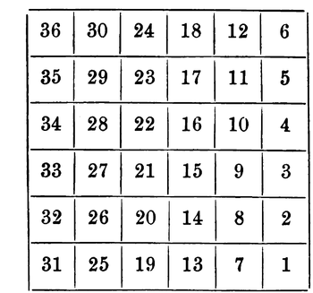 Plan for numbering sections of a township adopted May 20, 1785

Contents
History
The Continental Congress appointed a committee consisting of the following men:
- Thomas Jefferson (Virginia) — Chairman
- Hugh Williamson (North Carolina)
- David Howell (Rhode Island)
- Elbridge Gerry (Massachusetts)
- Jacob Read (South Carolina)
On May 7, 1784, the committee reported “An ordinance for ascertaining the mode of locating and disposing of lands in the western territories, and for other purposes therein mentioned.” The ordinance required the land be divided into “hundreds of ten geographical miles square, each mile containing 6086 and 4-10ths of a foot” and “sub-divided into lots of one mile square each, or 850 and 4-10ths of an acre”,[10] numbered starting in the northwest corner, proceeding from west to east, and east to west consecutively. After debate and amendment, the ordinance was reported to Congress April 26, 1785. It required surveyors “to divide the said territory into townships seven miles square, by lines running due north and south, and others crossing these at right angles. --- The plats of the townships, respectively, shall be marked into sections of one mile square, or 640 acres” This is the first recorded use of the terms “township” and “section.”[11]
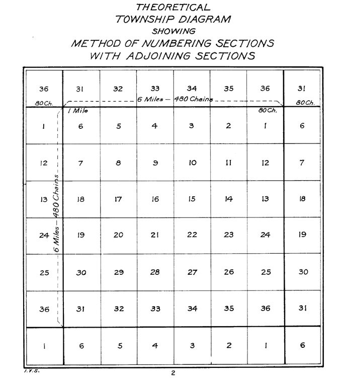
On May 3, 1785, William Grayson of Virginia made a motion seconded by James Monroe to change “seven miles square” to “six miles square.” The ordinance was passed on May 20, 1785. The sections were to be numbered starting at 1 in the southeast and running south to north in each tier to 36 in the northwest. The surveys were to be performed under the direction of the Geographer of the United States, (Thomas Hutchins).[11] The Seven Ranges, the privately surveyed Symmes Purchase, and , with some modification, the privately surveyed Ohio Company of Associates, all of the Ohio Lands were the surveys completed with this section numbering.[12]
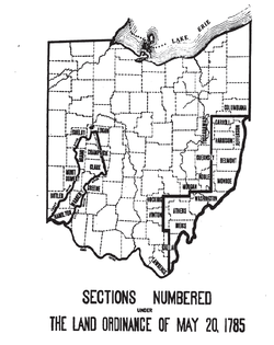 Locations in Ohio using Land Ordinance of 1785 Section Numbering
The Act of May 18, 1796[13] provided for the appointment of a surveyor-general to replace the office of Geographer of the United States, and that “sections shall be numbered, respectively, beginning with number one in the northeast section, and proceeding west and east alternately, through the township, with progressive numbers till the thirty-sixth be completed.” All subsequent surveys were completed with this boustrophedonical section numbering system, except the United States Military District of the Ohio Lands which had five mile (8 km) square townships as provided by the Act of June 1, 1796,[14] and amended by the Act of March 1, 1800.[11][15]
Howe and others give Thomas Hutchins credit for conceiving the rectangular system of lots of one square mile in 1764 while a captain in the Sixtieth, or, Royal American, Regiment, and engineer to the expedition under Col. Henry Bouquet to the forks of the Muskingum, in what is now Coshocton County, Ohio. It formed part of his plan for military colonies north of the Ohio, as a protection against Indians. The law of 1785 embraced most of the new system.[16] Treat, on the other hand, notes that tiers of townships were familiar in New England, and insisted on by the New England legislators.[17]
See also
notes
- ^ Vernon Carstensen, "Patterns on the American Land." Journal of Federalism, Fall 1988, Vol. 18 Issue 4, pp 31-39
- ^ Richard P. McCormick, "The 'Ordinance' of 1784?," William and Mary Quarterly, Jan 1993, Vol. 50 Issue 1, pp 112-22
- ^ Journal of Continental Congress, Vol. 28, p. 375, May 20, 1785 Library of congress
- ^ C. Albert White, A History of the Rectangular Survey System (Bureau of Land Management, 1983)
- ^ White, A History of the Rectangular Survey System
- ^ Williamson 1880 : 226
- ^ The Oregon Territory Act (August 14, 1848) 9 Stat. 323 initiated practice of setting aside section 36 for schools: Section 20 “And be it further enacted, That when the lands in the said Territory shall be surveyed under the direction of the Government of the United States, preparatory to bringing the same into market, sections numbered sixteen and thirty-six in each township in said Territory shall be, and the same is hereby, reserved for the purpose of being applied to schools in said Territory, and in the States and Territories hereafter to be erected out of the same.”
- ^ Knepper 2002 : 9
- ^ Knepper 2002 : 51
- ^ Journal of Continental Congress, Vol. 27, p. 446, May 28, 1784 Library of congress
- ^ a b c Higgins 1887 : 33–34, 78–82
- ^ Peters 1918 : 58
- ^ 1 Stat. 464 - Text of Act of May 18, 1796 Library of Congress
- ^ 1 Stat. 490 - Text of Act of June 1, 1796 Library of Congress
- ^ 2 Stat. 14 - Text of Act of March 1, 1800 Library of Congress
- ^ Howe 1907 : 134
- ^ Treat 1910 : 179-182
References and further reading
- Higgins, Jerome S. (1887). Subdivisions of the Public Lands, Described and Illustrated, with Diagrams and Maps. Higgins & Co. http://books.google.com/books?id=r-jSAAAAMAAJ.
- Howe, Henry (1907). Historical Collections of Ohio, The Ohio Centennial Edition. 1. The State of Ohio. http://books.google.com/books?id=OXIOAAAAIAAJ&pg=PA134.
- Knepper, George W (2002). The Official Ohio Lands Book. The Auditor of the State of Ohio. http://www.auditor.state.oh.us/Publications/General/OhioLandsBook.pdf.
- Peters, William E (1918). Ohio Lands and Their Subdivision. W.E. Peters. http://books.google.com/books?id=HiApAAAAYAAJ&pg=PA58.
- Treat, Payson Jackson (1910). The National Land System 1785-1820. E.B. Treat and Co. http://books.google.com/books?id=OZI0AAAAIAAJ&pg=PA179.
- Williamson, James A.; Donaldson, Thomas (1880). The Public Domain. Its History, with Statistics. Government Printing Office. http://books.google.com/books?id=ZJzm5PtTY9gC&pg=PA226.
- Johnson, Hildegard Binder. Order upon the Land: The U.S. Rectangular Land Survey and the Upper Mississippi Country (1977)
- Geib, George W.. "The Land Ordinance of 1785: A Bicentennial Review," Indiana Magazine of History, March 1985, Vol. 81 Issue 1, pp 1–13
External links
Categories:- 1785 in law
- 1785 in the United States
- History of the Midwestern United States
- United States federal public land legislation
- History of the United States (1776–1789)
- Land surveying of the United States
- Ordinances of the Continental Congress
- Pre-state history of Ohio

Wikimedia Foundation. 2010.