- Ohio Company of Associates
-
For the earlier Ohio Company of Virginia, see the Ohio Company.
The Ohio Company of Associates, also known as the Ohio Company, was a land company which is today credited with becoming the first non-American Indian group to settle in the present-day state of Ohio. It was formed on March 1, 1786, by General Rufus Putnam, Benjamin Tupper, Samuel Holden Parsons and Manasseh Cutler, who had met in Boston, Massachusetts, at The Bunch-of-Grapes tavern, located on King Street to discuss the settlement of the territory around the Ohio River.
Cutler was sent to New York to negotiate with the Congress of the Confederation to help the company secure a claim on the portion of land they were interested in. While there, Cutler aligned himself with William Duer, secretary of the U.S. Treasury Board. Duer and his associates formed a steadfast group of New York speculators determined for the settlement of the area west of the Appalachians.[1] At this time, Congress desperately needed revenue. It was the economic strain and the pressure from Duer and Cutler that helped them to secure the incorporation in the Northwest Ordinance, for the government of the Northwest Territory of the paragraphs which prohibited slavery and provided for public education and for the support of the ministry.
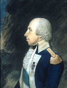
After the creation of the Northwest Territory, Cutler suggested that the governor of the territory be General Arthur St. Clair, who was then serving as the President of Congress. Once St. Clair had been appointed to his new position, two new contracts were signed on October 27, 1787 between St. Clair, Cutler, and Major Winthrop Sargent, the secretary of the Ohio Company. The first was for the absolute purchase for the Ohio Company, of 1,500,000 acres (6,000 km²) of land at the confluence of the Ohio and Muskingum rivers from a point near the site of the present Marietta, to a point nearly opposite the site of the present Huntington, West Virginia, for a payment of $1 million in government securities, then worth about 12¢ specie to the dollar. The contract also provided that one section of land in every township be devoted to the maintenance of public schools, another section be set apart for religious uses, and two entire townships be reserved for a university.
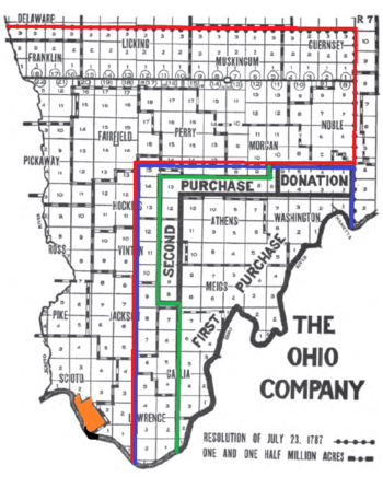
 The proposed purchase by the Scioto Company is shown in red. The proposed purchase of 1,500,000 acres (6,100 km2) by the Ohio Company is in blue. The final dimensions of the Ohio Company is in green, including the First Purchase, Second Purchase, and Donation Tract.
The second contract was an option to buy all the land between the Ohio and the Scioto rivers and the western boundary line of the Ohio Company's tract, extending north of the tenth survey township from the Ohio, this tract being preempted by Manasseh Cutler and Winthrop Sargent for themselves and others actually for the Scioto Company. Cutler's original intent was to buy for the Ohio Company only about 1,500,000 acres (6,000 km²), but on the July 27, Congress authorized a grant of about 5,000,000 acres (20,000 km²) of land for $3,500,000; a reduction of one-third was allowed for bad tracts, and it was also provided that the lands could be paid for in United States securities. On the same day, Cutler and Sargent for themselves and associates transferred to William Duer, then Secretary of the Treasury Board, and his associates one equal moiety of the Scioto tract of land mentioned in the second contract, it being provided that both parties were to be equally interested in the sale of the land, and were to share equally any profit or loss. However, the interest of the Scioto Company was only speculative, and their contract lapsed before any land was purchased. In contrast, the Ohio Company held a genuine plan of settlement.
The company made its first installment of $500,000, but was unable to raise the second $500,000. It settled for a purchase of 750,000 acres (3,000 km2), plus the two townships for College Lands and the reserved School Lands and Ministerial Lands sections in each township for a total area of 913,833 acres (3,698.15 km2), called the First Purchase.[2] The lands were privately surveyed, but on the same plan of townships, ranges, and sections as the adjacent Seven Ranges under the procedure of the Land Ordinance of 1785.[3][4]
In 1788, General Rufus Putnam laid out the plans for Marietta, the first permanent settlement in the present state of Ohio. Pioneers were sent out by the Ohio Company from New England to Marietta. The first purchase was in Washington, Meigs, Gallia, Lawrence and Athens Counties.
Difficulties with Indians during the Northwest Indian War, including the Big Bottom Massacre, led Congress in 1792 to donate 100,000 acres (400 km2) on the north edge of the first purchase as a buffer against incursion, called the Donation Tract, in Washington and Morgan Counties. Many associates of the company held army bounty warrants, which they could exchange for federal land, totaling 142,900 acres (578 km2). Later in 1792, another purchase was made of 214,285 acres (867.18 km2) in Morgan, Hocking, Vinton and Athens Counties using these bounties, with the 1/3 discount for bad lands, as in the first purchase.[5] The Second Purchase had no sections set aside for schools or ministry. The Second Purchase is also known as the Purchase on the Muskingum.[4]
In 1796, the Ohio Company divided its shares and ceased to be a genuine land company.
TRACT AREA
(acres)AREA
(Metric Unit)First
Purchase913833 Something Second
Purchase214285 Something Donation
Tract100000 Something Total 1228118 Something Contents
See also
Bibliography
 This article incorporates text from a publication now in the public domain: Chisholm, Hugh, ed (1911). Encyclopædia Britannica (11th ed.). Cambridge University Press.
Additional references include:
- Hildreth, S.P. (1848). Pioneer History: Being an Account of the First Examinations of the Ohio Valley, and the Early Settlement of the Northwest Territory. H. W. Derby and Co.. http://books.google.com/books?id=yak6sfwDB5gC.
- Hulbert, Archer Butler (1917). The Records of the Original Proceedings of the Ohio Company, Volume I. Marietta Historical Commission. http://books.google.com/books?id=3x8mAAAAMAAJ.
- Hulbert, Archer Butler (1917). The Records of the Original Proceedings of the Ohio Company, Volume II. Marietta Historical Commission. http://books.google.com/books?id=cCAmAAAAMAAJ.
- Summers, Thomas J. (1903). History of Marietta. The Leader Publishing Co.. http://books.google.com/books?id=6BImAAAAMAAJ.
References
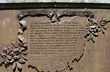
- ^ A bronze historical plaque on the wall of Federal Hall, New York, commemorates the Ohio Company, with a map of Ohio.
- ^ Knepper, George W (2002). The Official Ohio Lands Book. The Auditor of the State of Ohio. pp. 27–30. http://www.auditor.state.oh.us/Publications/General/OhioLandsBook.pdf.
- ^ Text of Ordinance of May 20, 1785 Library of Congress
- ^ a b Peters, William E (1918). Ohio Lands and Their Subdivision. W.E. Peters. pp. 237–258. http://books.google.com/books?id=HiApAAAAYAAJ&pg=PA237&lpg=PA237.
- ^ 6 Stat. 8 - Text of Act of April 21, 1792 Library of Congress
External links
- Manuscripts and Documents of the Ohio Company of Associates - Marietta College.
- Ohio Company of Associates - Ohio History Central.
Ohio Lands Six-Mile
Rectangular
System SurveysCongress Lands • Congress Lands North of Old Seven Ranges • Congress Lands West of Miami River • Congress Lands East of Scioto River • North and East of the First Principal Meridian • South and East of the First Principal Meridian • Michigan Survey • Ohio Company of Associates • Purchase on the Muskingum • Old Seven Ranges • Symmes Purchase • Toledo Strip
Five-Mile
Rectangular
System SurveysConnecticut Western Reserve • Firelands • United States Military DistrictIndiscriminate
SurveysFrench Grant • Indian Land Grants • Moravian Indian Grants • Gnadenhutten Tract • Salem Tract • Schoenbrunn Tract • Donation Tract • Twelve Mile Square Reservation • Two Mile Square Reservation • Zane's Tractsmetes and bounds
SurveyLand Grants Canal Lands • Miami & Erie Canal Lands • Ohio & Erie Canal Lands • College Lands • College Township • Dohrman Tract • Ephraim Kimberly Grant • Fort Washington • Maumee Road Lands • Ministerial Lands • Refugee Tract • Salt Reservations • School Lands • Turnpike LandsOther Dolerman’s Grant • Historic regions of the United States • Scioto Company • Northwest Territory • Ohio CountryImages from Commons Categories:- Companies established in 1786
- Early American land companies
- Pre-state history of Ohio
- Marietta, Ohio
Wikimedia Foundation. 2010.


