- Congress Lands West of Miami River
-
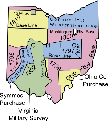 The Congress Lands West of Miami River are the pink area labeled 1798 in far lower left
 The Congress Lands West of Miami River
The Congress Lands West of Miami River was a land tract in southwest Ohio that was established by the Congress late in the 18th century. It is located south of the Greenville Treaty Line, east of Indiana, and north of the Great Miami River. The original survey in 1798 contained a triangular shaped slice of land, now located in Indiana, that extended to the Greenville line as it ran from Fort Recovery to opposite the mouth of the Kentucky River.
Contents
History
In 1787, lands in the Ohio Country east of the Great Miami River were sold by the Continental Congress to Judge John Cleves Symmes of New Jersey, known as Symmes Purchase. With the Treaty of Greenville in 1795, lands west and north of the Miami, and south and east of the Greenville Treaty Line were ceded by Indians, and open to settlement.
The Survey
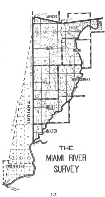
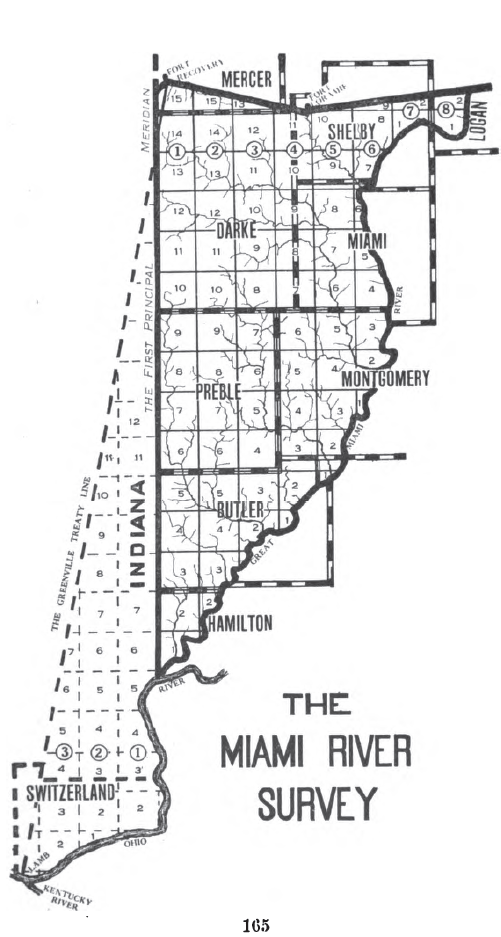
The survey commenced in 1798. Land was to be systematically surveyed into square "townships", six miles (9.656 km) on a side created by lines running north-south intersected by east-west lines. Townships were to be arranged in north-south rows called ranges. These townships were sub-divided into thirty-six "sections" of one square mile (2.59 km²) or 640 acres. These ranges, townships, and sections were to be systematically numbered.[1] The First Principal Meridian was established to run northward from the confluence of the Great Miami River and the Ohio River. Ranges were numbered east and west from this meridian. Townships east of the meridian were numbered from south to north, starting at the Great Miami River. Townships west of the meridian were numbered from south to north starting at the Ohio River. Thus, townships in adjacent ranges rarely have the same number.[2] Sections in each township are numbered according to the plan adopted in the Act of May 18, 1796.[3] The Ohio Enabling Act of 1802 established the western boundary of the state along the First Principal Meridian.[1][4]

Land Sales
Section 4 of the Land Act of May 18, 1796 provided that the lands in the survey area be sold at Cincinnati. The Land Act of May 10, 1800[5] established a Federal Land Office at Cincinnati for sales of these lands. Sales were also conducted from the nation’s capital at the General Land Office. Local offices were eventually closed. The State of Ohio also eventually sold lands granted to them by the federal government, such as section 16 of each township.
College Township
Congress declared in September, 1803 that 23,321 acres (36.4 square miles) located in the Congress Lands West of Miami River were to be set aside for “an academy, other public schools and seminaries of learning.” It benefited Miami University, chartered in 1809 by the state legislature in a town the legislature named Oxford.[6] The College Township is in township 5 of range 1 east, now the civil township called Oxford Township, Butler County, Ohio.
Modern Times
The survey in Ohio in modern times includes all or parts of nine counties: Butler, Darke, Hamilton, Logan, Mercer, Miami, Montgomery, Preble, and Shelby
See also
Notes
- ^ a b Knepper 2002 : 42-43
- ^ Peters, William E (1918). Ohio Lands and Their Subdivision. W.E. Peters. p. 164. http://books.google.com/books?id=HiApAAAAYAAJ&pg=PA164&lpg=PA164.
- ^ 1 Stat. 464 - Text of Act of May 18, 1796 Library of Congress
- ^ 2 Stat. 173 - Text of Act of April 30, 1802 Library of Congress
- ^ 2 Stat. 73 - Text of Act of May 10, 1800 Library of Congress
- ^ Knepper 2002 : 68
References
- Knepper, George W (2002). The Official Ohio Lands Book. The Auditor of the State of Ohio. http://www.auditor.state.oh.us/Publications/General/OhioLandsBook.pdf.
External links
- Ohio History Central- Congress Lands
- Ohio Dept. of Natural Resources: Map of Original Land Subdivisions of Ohio (pdf)
Ohio Lands Six-Mile
Rectangular
System SurveysCongress Lands • Congress Lands North of Old Seven Ranges • Congress Lands West of Miami River • Congress Lands East of Scioto River • North and East of the First Principal Meridian • South and East of the First Principal Meridian • Michigan Survey • Ohio Company of Associates • Purchase on the Muskingum • Old Seven Ranges • Symmes Purchase • Toledo Strip
Five-Mile
Rectangular
System SurveysConnecticut Western Reserve • Firelands • United States Military DistrictIndiscriminate
SurveysFrench Grant • Indian Land Grants • Moravian Indian Grants • Gnadenhutten Tract • Salem Tract • Schoenbrunn Tract • Donation Tract • Twelve Mile Square Reservation • Two Mile Square Reservation • Zane's Tractsmetes and bounds
SurveyLand Grants Canal Lands • Miami & Erie Canal Lands • Ohio & Erie Canal Lands • College Lands • College Township • Dohrman Tract • Ephraim Kimberly Grant • Fort Washington • Maumee Road Lands • Ministerial Lands • Refugee Tract • Salt Reservations • School Lands • Turnpike LandsOther Dolerman’s Grant • Historic regions of the United States • Scioto Company • Northwest Territory • Ohio CountryImages from CommonsCategories:- Former regions and territories of the United States
- Geography of Ohio
- Pre-state history of Ohio
- History of the Midwestern United States
- Land surveying of the United States
- Butler County, Ohio
- Darke County, Ohio
- Hamilton County, Ohio
- Logan County, Ohio
- Mercer County, Ohio
- Miami County, Ohio
- Montgomery County, Ohio
- Preble County, Ohio
- Shelby County, Ohio

Wikimedia Foundation. 2010.