- M-153 (Michigan highway)
-
M-153
Ford Road 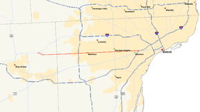
M-153 highlighted in redRoute information Maintained by MDOT Length: 25.127 mi[2][3] (40.438 km) Existed: December 2, 1930[1] – present Major junctions West end:  M-14 near Ann Arbor
 I-275 in Canton
 US 24 in Dearborn
East end: 
 I-94 / US 12 at Detroit western city line
Location Counties: Washtenaw, Wayne Highway system Michigan State Trunkline Highway System
Interstate • US • State←  M-152
M-152M-154  →
→M-153 is a state trunkline highway in the U.S. state of Michigan. It is also known as Ford Road for nearly its entire length, except for its westernmost portion where it splits from Ford Road and junctions with the M-14 freeway. Named for William Ford, father of Henry Ford, Ford Road runs from near Dixboro to the Dearborn–Detroit border, where it junctions with Interstate 94 (I-94) and US Highway 12 (US 12) just east of Wyoming Avenue.
Contents
Route description
A small portion of M-153 in Dearborn is a controlled-access expressway. Ford Road serves as the zero-mile line for the Detroit area's Mile Road System.
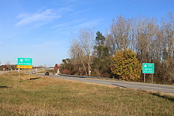 Intersection of M-153 and M-14, facing west, viewed from intersection of M-153 and Plymouth Road
M-153 starts as an interchange with M-14 in Superior Township east of Ann Arbor. The highway starts as an expressway curving southeasterly to meet Ford Road where it curves to the east at Frains Lake Road. Ford Road continues west of here to end at Plymouth Road south of the M-14 freeway, and east of this location, M-153 follows Ford Road through wooded, partially developed terrain to the Washtenaw–Wayne county line at Napier Road.[4][5] Near the county line are farms until Ford Road reaches residential subdivisions at Ridge Road in Canton Township. At the east edge of the township, Ford Road meets I-275 at exit 25 before passing into Westland between Lotz and Hix roads.
The interchange with I-275 is built over the western crossing of Willow Creek, a tributary of the River Rouge; the eastern crossing is located between Hix and Newburgh roads near Central City Park.[5] Ford Road continues east, forming a section of the Garden City boundary near Venoy Road. The trunkline crosses into Dearborn Heights at Inkster Road. It forms the boundary between Dearborn and Dearborn Heights between Gulley and Evergreen Roads, crossing US 24/Telegraph Road in between. East of Telegraph Road, M-153/Ford Road is built to expressway standards complete with interchanges at Evergreen Road, M-39/Southfield Freeway and Greenfield Road. The highway crosses the River Rouge north of the Dearborn Country Club west of Evergreen Road. Ford Road ends at Wyoming Avenue.[5] M-153 turns south along Wyoming Avenue to cross I-94 at exit 210. This interchange is also the location where I-94 and US 12/Michigan Avenue cross, marking the eastern end of M-153 at Michigan Avenue.[4]
History
Ford Road was named for William Ford, father of automobile pioneer Henry Ford. The elder Ford was born in Ireland and settled in Dearborn Township in 1847. William's carpentry business lead him around to regional businesses and neighbors, traveling the area until he took up the family business of farming after marriage to Mary Litogot. They settled on a farm near the intersection of modern-day Ford Road and Greenfield Avenue; this farm was Henry's birthplace in 1863. Settling into his family life, William started serving the local community. He was a road commissioner, school board member and a justice of the peace. In honor of his accomplishments, Ford Road was named in his honor before his death in March 1905.[1]
Ford Road remained in township jurisdiction until August 29, 1924 when it was transferred to Wayne County control. It was transferred again to state control on December 2, 1930. The Michigan State Highway Department designated it M-153 upon transfer to their responsibility.[1] The highway designation is determined to continue west of the county line into Washtenaw County as a northerly bypass of Ann Arbor, but the segment between Canton Center Road and US 12 on Plymouth Road was not built at the time.[6] The first extension west was finished in 1933 from the county line to Napier Road.[7] The road was widened into a major thoroughfare between Detroit and Ann Arbor in 1934, to relieve congestion on Michigan Avenue.[1] The highway bypass of Ann Arbor was cancelled by 1935, leaving the western terminus at US 12/Plymouth Road.[8]
Construction of a northerly freeway bypass of Ann Arbor along M-14 to M-153 was completed by 1965. A second freeway section was built between Ford Road at Frains Lake Road to the contemporary end of the M-14 freeway. This second freeway was assigned as part of M-153 and the former routing along Ford Road west to Plymouth Road was removed from the state trunkline highway system.[9] A reconstruction project along M-153 in 1973 was completed, bringing the highway up to expressway standards. Several interchanges were built along the segment starting west of the M-39/Southfield Freeway to I-94 in Dearborn.[10][11] The last extension moved the western terminus in 1980 when the M-14 freeway was completed, and M-153 was extended along a section of freeway used to connect the previous end of the M-14 freeway to Plymouth Road.[12]
Major intersections
County Location Mile[2][3] Destinations Notes Washtenaw Superior Township 0.000 M-14 – Ann Arbor, DetroitExit 10 on M-14 Wayne Canton 10.337 I-275 – Flint, ToledoExit 25 on I-275 Dearborn 14.005 US 24 (Telegraph Road)19.012  M-39 (Southfield Freeway)
Exit 7 on M-39 25.050–
25.127 I-94 – Detroit, Chicago
US 12 (Michigan Avenue)Exit 210 on I-94 1.000 mi = 1.609 km; 1.000 km = 0.621 mi References
- ^ a b c d Barnett, Ph.D., LeRoy (2004). A Drive Down Memory Lane: The Named State and Federal Highways of Michigan. Allegan Forest, Michigan: Priscilla Press. p. 84. ISBN 1-886167-24-9.
- ^ a b Michigan Department of Transportation (2009). Control Section/Physical Reference Atlas (Map). http://mdotwas1.mdot.state.mi.us/public/maps/pr/. Retrieved July 26, 2009.
- ^ a b "MDOT Physical Reference Finder Application". Michigan Department of Transportation. 2009. http://www.mcgi.state.mi.us/prfinder/. Retrieved April 9, 2010.
- ^ a b Michigan Department of Transportation (2008). Official Department of Transportation Map (Map). 1 in.:15 mi/1 cm:9 km. Section E5–E11, Detroit Area inset.
- ^ a b c Google, Inc. Google Maps – M-153 & Ann Arbor Rd, Ann Arbor, MI 48105 to I-94W (Map). Cartography by Google, Inc. http://maps.google.com/maps?f=d&saddr=M-153+%26+Ann+Arbor+Rd,+Ann+Arbor,+MI+48105&daddr=42.326062,-83.322372+to:I-94+W&hl=en&geocode=%3B%3BFTDjhQIdOCEL-w&mra=dpe&mrcr=0&mrsp=1&sz=11&via=1&sll=42.345858,-83.270187&sspn=0.322766,0.464172&ie=UTF8&ll=42.319463,-83.383484&spn=0.322902,0.464172&t=h&z=11. Retrieved November 4, 2008.
- ^ Michigan State Highway Department (May 15, 1931). Official Highway Service Map (Map). Cartography by H.M. Gousha.
- ^ Michigan State Highway Department (July 1, 1933). Official Highway Service Map (Map). Cartography by H.M. Gousha.
- ^ Michigan State Highway Department (May 15, 1935). 1935 Official Michigan Highway Map (Map). Cartography by Rand McNally.
- ^ Michigan State Highway Department (1965). Official Highway Map (Map).
- ^ Michigan Department of State Highways (1973). Official Highway Map (Map). 1 in.:14.5 mi..
- ^ Michigan Department of State Highways and Transportation (1974). Official Highway Map (Map). 1 in.:14.5 mi..
- ^ Michigan Department of Transportation (1980–1981). Official Transportation Map (Map). 1 in.:14.5 mi./1 in.:23 km..
External links
Categories:- State highways in Michigan
- Transportation in Wayne County, Michigan
- Transportation in Washtenaw County, Michigan


Wikimedia Foundation. 2010.