- U.S. Route 25
-
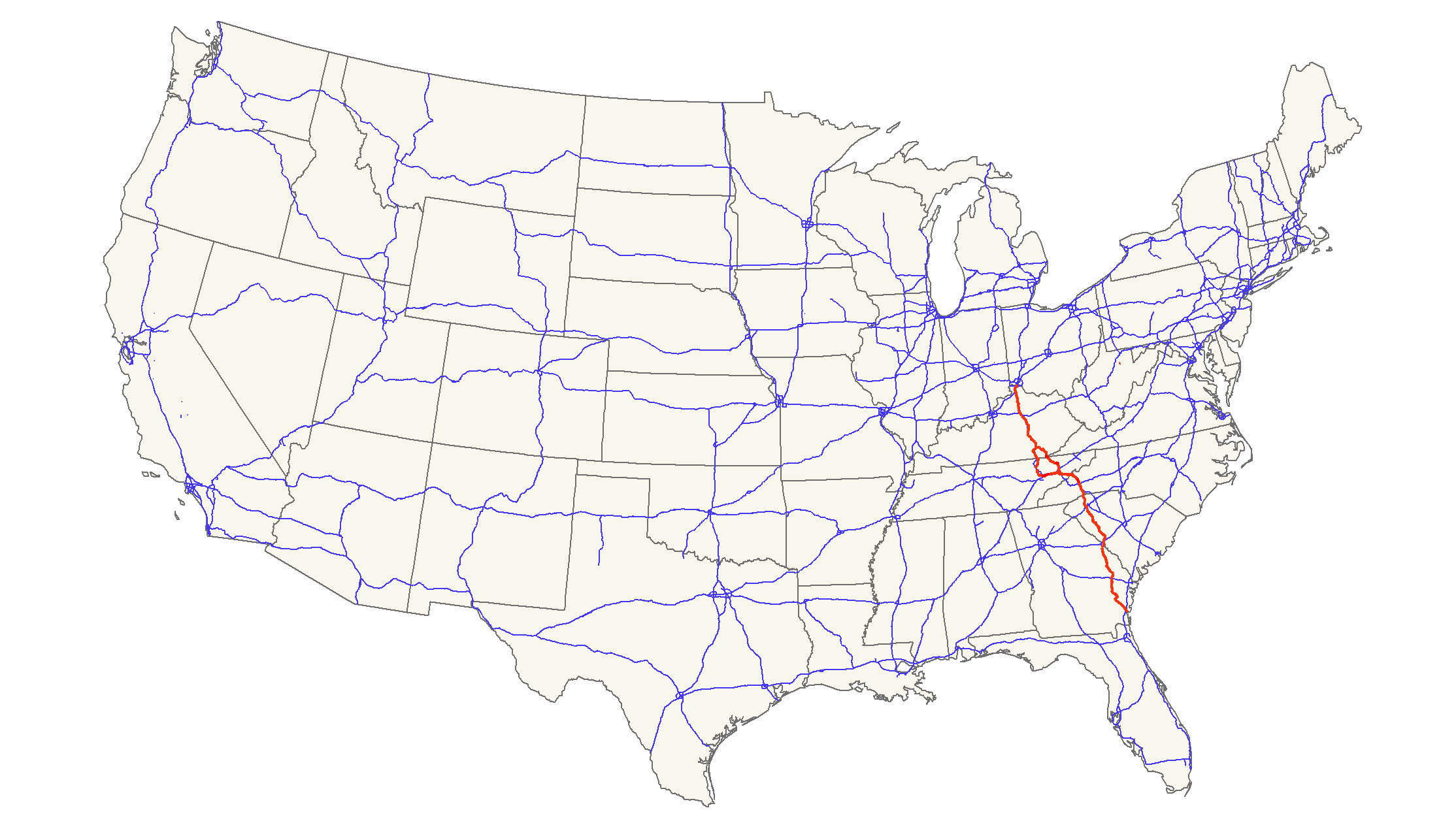
U.S. Route 25
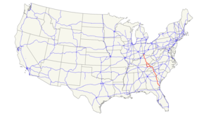
Route information Length: 750 mi[1] (1,210 km) Existed: 1926[1] – present Major junctions South end: 
 US 17 / US 341 in Brunswick, GA
 I-95 near Brunswick, GA
 I-16 near Register, GA
 I-20 near North Augusta, SC
 I-85 in Greenville, SC

 I-26 / US 74 near Flat Rock, NC
 I-40 in Asheville, NC


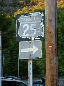
 US-25E / US-25W / US-70 in Newport, TN
US 25E / US 25W in North Corbin, KY
 I-64 near Lexington, KY
 I-71 / I-75 in Covington, KY
North end: 
 US 42 / US 127 in Covington, KY
Highway system United States Numbered Highways
List • Bannered • Divided • ReplacedU.S. Route 25 is a north–south United States highway that runs for 750 miles (1,210 km) from Brunswick, Georgia to the Ohio state line in Covington, Kentucky.
Contents
Route description
Georgia
Starting at the intersection of US 17/SR 25 in Brunswick, US 25 goes northwest to Jesup then northeast to Ludowicki. It then stays at a general north route through the cities of Statesboro, Millen, Waynesboro and finally Augusta, where it crosses the Savannah River into South Carolina. The overall majority of the route is 4-lane.
South Carolina
Entering South Carolina from Augusta, Georgia, US 25 goes north through downtown North Augusta, connecting with I-20 just outside of town. US 25 goes northwesterly through the cities of Edgefield, Greenwood, and Greenville; going due north at Travelers Rest to the North Carolina state line. Majority of the route is 4-lane, with various sections at expressway grade.
From Interstate 85 southwest of Greenville, South Carolina to Interstate 26 southeast of Hendersonville, North Carolina, US 25, is Corridor W of the Appalachian Development Highway System.[2]
North Carolina
Main article: U.S. Route 25 in North CarolinaFrom the South Carolina state line, US 25 becomes a freeway for 9 miles (14 km) before connecting with I-26/US 74 near Flat Rock. Splitting from I-26/US 74 near Fletcher, it goes north through Arden, Biltmore Forest, and downtown Asheville, before reconnecting with I-26 near Woodfin. At Weaverville, US 25 and US 70 travel northwesterly together, through Marshall and Hot Springs into Tennessee.
Tennessee
Continuing for 20 miles (32 km) from the North Carolina state line to Newport, with US-70, US-25 splits into US-25E and US-25W. US-25E goes north through the cities of Morristown, Tazewell, and Harrogate, entering Kentucky via the Cumberland Gap Tunnel. US-25W goes west first to Knoxville then parallels I-75 into Kentucky.
Kentucky
Entering Kentucky from two locations, US 25E goes through the cities of Middlesboro and Barbourville, while US 25W continues its parallels I-75; both converge in Corbin becoming US 25 again (though US 25E continues west as a connector road to I-75). US 25 parallels I-75 throughout Kentucky, connecting the cities of London, Berea, Richmond, Lexington, and Dry Ridge. US 25 ends in Covington at the Ohio state line over the Ohio River; US 42/US 127 continue into Cincinnati.
History
US 25 originally extended northward into Ohio and Michigan before Interstate 75 between Detroit and Cincinnati and Interstate 94 between Detroit and Port Huron, Michigan, made most of US 25 superfluous north of Cincinnati. In Michigan, M-25 continues as the designation of old US 25 between Port Austin and Port Huron. Some old maps disagree on whether the east–west segment of what is now M-25 between Bay City was US 25 or M-25; for that discussion see M-25.
Relics of US 25 between Brownstown Township, Michigan, (a suburb of Detroit) and Cygnet, Ohio, include US 24, M-125, and State Route 25.
US 25 in Michigan and Ohio was historically known as Dixie Highway, and the road is still so named in some places. It may also be known as "County Road 25-A" through some parts of Ohio.
Until 1996 when the Cumberland Gap Tunnel was opened to traffic, from Middlesboro, Kentucky, US 25E climbed the Cumberland Mountains and along the historic Wilderness Road, passed through the Cumberland Gap into Virginia then heading south to enter Tennessee.
Old US 25 north of the intersection of US 11W in Tennessee crossed over Clinch Mountain, following a notorious route consisting of considerable elevation gain and many switchbacks, some of which were full hairpin turns.
See also
Suffixed routes
- U.S. Route 25E
- U.S. Route 25W
References
- ^ a b US Highways from US 1 to US 830 Robert V. Droz
- ^ ADHS Approved Corridors and Termini
External links
 Main U.S. Routes
1 2 3 4 5 6 7 8 9 10 11 12 13 14 15 16 17 18 19 20 21 22 23 24 25 26 27 28 29 30 31 32 33 34 35 36 37 38 40 41 42 43 44 45 46 48 49 50 51 52 53 54 55 56 57 58 59 60 61 62 63 64 65 66 67 68 69 70 71 72 73 74 75 76 77 78 79 80 81 82 83 84 85 87 89 90 91 92 93 94 95 96 97 98 99 101 163 400 412 425 Lists U.S. Routes • Bannered • Divided • Bypassed Browse numbered routes ←  SR-24
SR-24TN SR-25  →
→←  I-24
I-24KY KY 26  →
→Major Highways in Greenville County, SC Freeways Major U.S. Highways US 25 (Augusta Road/White Horse Road/Poinsett Highway) • US 29 (Mills Avenue/Church Street/Wade Hampton Boulevard) • US 123 (New Easley Highway/Easley Bridge Road/Academy Street) • US 276 (Laurens Road/Stone Avenue/Poinsett Highway/Geer Highway)
Major South Carolina State Highways SC 8 • SC 11 (Cherokee Foothills Scenic Highway) • SC 14 (Pelham Highway) • SC 146 (Woodruff Road) • SC 183 (Farrs Bridge Road/Cedar Lane Road) • SC 291 (Pleasantburg Drive)
Categories:- U.S. Highway System
- U.S. Route 25
- U.S. Highways in Tennessee
- U.S. Highways in Kentucky
- U.S. Highways in South Carolina
- U.S. Highways in Georgia (U.S. state)
- Transportation in Cincinnati, Ohio


Wikimedia Foundation. 2010.