- M-136 (Michigan highway)
-
M-136 
Route information Maintained by MDOT Length: 17.52 mi[1] (28.20 km) Existed: 1931 – present Major junctions West end:  M-19 at Brockway
East end:  M-25 near Fort Gratiot
Location Counties: St. Clair Highway system Michigan State Trunkline Highway System
Interstate • US • State←  M-135
M-135M-137  →
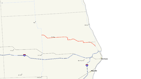
→M-136 is a state highway in the US state of Michigan that runs from Brockway to north of Port Huron in the lower Thumb area of the Lower Peninsula. The route serves as a connector between M-19 and the coastal route, M-25.
Contents
Route description
M-136 begins at a junction with M-19 just south of Brockway on the north side of Mill Creek. The route heads eastward for a short distance before bending to the southeast on Beard Road. The road then turns eastward and heads toward Avoca. The route continues in this direction for a distance before turning southward on Glyshaw Road and then turning east, returning to Bear Road. From here, it continues on a general east-southeast track as it heads towards Gardendale. The road then branches southeastward to connect with M-25 two miles (3 km) from I-94 and I-69 and their International Border crossing on the Blue Water Bridge in Port Huron.
History
M-136 was commissioned in 1931 as a route connecting what was M-19 and M-51 (present day M-25). In 1962, the M-51 designation that existed from M-136 to US-25A (present day Pine Grove Avenue) was removed and declared an extension of M-136, bringing the route to its present day alignment, it has remained as such since this time.
Major intersections
The entire highway is in St. Clair County.
Location Mile[2] Destinations Notes Brockway 0.00  M-19
M-19Avoca 3.95 Kilgore Road Ruby 8.76 Beard Road Fort Gratiot 16.09 Keewahdin Road & Pine Grove Avenue 17.52 
 M-25 / GLCT
1.000 mi = 1.609 km; 1.000 km = 0.621 mi References
- ^ Michigan Highways: Highways 120 through 139 Christopher J. Bessert. URL accessed 2 November 2006.
- ^ "MiGDL - Center for Geographic Information - Geographic Data Library". Michigan Department of Information Technology. May 2007. http://www.mcgi.state.mi.us/mgdl/?rel=thext&action=thmname&cid=14&cat=MI+Geographic+Framework+All+Roads+%28v7b%29. Retrieved February 9, 2008.
External links
Categories:- State highways in Michigan
Wikimedia Foundation. 2010.

