- M-106 (Michigan highway)
-
M-106 
M-106 highlighted in redRoute information Maintained by MDOT Length: 28.37 mi[1] (45.66 km) Existed: 1928 – present Major junctions South end: 


 BL I-94 / BUS US 127 / M-50 at Jackson
 M-52 at Stockbridge
North end:  M-36 at Gregory
Location Counties: Jackson, Ingham, Livingston Highway system Michigan State Trunkline Highway System
Interstate • US • State←  M-105
M-105M-107  →
→M-106 is the designation given to a state trunkline highway in the Lower Peninsula of the US state of Michigan near the city of Jackson. M-106 travels in a southwest to northeast direction from Jackson to Gregory at a junction with M-36 just a few miles northwest of Hell. In Jackson, M-106 travels next to the G. Robert Cotton Correctional Facility, one of the world's largest maximum security prisons.
Contents
Route description
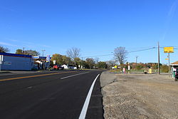
Intersection of M-106 (Plum Orchard Road) and Musbach Road, the boundary between Henrietta Township and Waterloo Township
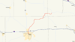
M-106 starts in downtown Jackson at the corner of Cooper Street and Michigan Avenue. Michigan Avenue runs east–west carrying Business Loop Interstate 94 (BL I-94), Business US 127 (BUS US 127) and M-50. Cooper Street runs north from here carrying M-106 through an interchange with I-94 and US 127 and north out of town. The highway curves northwest following Bunkerhill Road before turning onto Plum Orchard Road and running east into the community of Munith. M-106 merges onto Territorial Road east of the town before crossing the county line into Ingham County. South of Stockbridge, M-106 merges with M-52 and the two run concurrently into that community. M-106 turns east in the downtown and continues along Morton Road into Livingston County. The highway ends at a junction with M-36 in Gregory.
History
M-106 was first designated on June 28, 1928. It was routed from US 12/Michigan Avenue along Cooper Street to Bunkerhill Road, a total of 4.5 miles (7.2 km). This route was extended north to Stockbridge on December 8, 1930. A further realignment of M-36 resulted in the extension of M-106 to Gregory. Cooper Street in Jackson was converted to one-way, southbound traffic on November 30, 1967. A northbound routing along Milwaukee Street was established. The south end of southbound M-106 was trimmed back to end at BL I-94/BUS US 127/M-50. Two-way traffic was restored in 2004. M-106 was shifted only along Cooper Street (formerly Milwaukee Street) and Francis Street (formerly Cooper Street) is left as an unsigned trunkline.[1]
Major intersections
County Location Mile Destinations Notes Jackson Jackson 0.00 


 BL I-94 / BUS US 127 / M-50 (Michigan Avenue)
 I-94 / US 127 – Battle Creek, Ann Arbor, Lansing
Exit 139 on I-94/US 127 Ingham Stockbridge  M-52
M-52Livingston Gregory  M-36
M-361.000 mi = 1.609 km; 1.000 km = 0.621 mi References
- ^ a b Michigan Highways: Highways 100 through 119 Christopher J. Bessert. URL Accessed October 29, 2006.
External links
Categories:- State highways in Michigan
- Central Michigan
Wikimedia Foundation. 2010.


