- M-140 (Michigan highway)
-
M-140 
Route information Maintained by MDOT Length: 38.44 mi[2] (61.86 km) Existed: October 23, 1931[1] – present Major junctions South end: 
 BUS US 31 in Niles
 M-62 near Eau Claire
 I-94 near Watervliet
North end: 
 I-196 / US 31 at South Haven
Location Counties: Berrien, Van Buren Highway system Michigan State Trunkline Highway System
Interstate • US • State←  M-139
M-139US 141  →
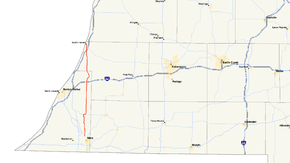
→M-140 is a short state trunkline highway in the US state of Michigan. the route is entirely within Berrien and Van Buren counties. Although it runs near M-40, it was not designated as a spur from M-40. M-140 originally only existed north of Watervliet, as a designation to replace a rerouted U.S. Highway 31 (US 31), and later was extended southward to north of Niles.[1]
Contents
Route description
M-140 connects Niles on the south with eastern Berrien County and South Haven to the north. It is Main St. in Watervliet north of the Interstate 94 (I-94) interchange, running around Paw Paw Lake. South of Watervliet, it intersects Territorial Road, and north of there it meets Red Arrow Highway, the former US 12. M-140 crosses into western Van Buren County about 5 miles (8.0 km) north of Watervliet. It also crosses and parallels the Van Buren Trail in Covert and connects the South Haven Area Regional Airport with I-196/US 31.
History
The birth of M-140 in Michigan dates back to the October 23, 1931 realignment of US 31 along the shoreline of Lake Michigan. Originally it ran from South Haven to Watervliet. M-140 was extended to Niles on November 12, 1934.[1]
Major intersections
County Location Mile[2] Destinations Notes Berrien Niles Charter Township 0.00 
 BUS US 31 (Old US 31/Front Street)
Southern terminus Pipestone Township 10.36  M-62 east – Dowagiac
Watervliet 23.72  I-94 – Detroit, Chicago
Exit 41 on I-94 Van Buren South Haven 38.44 

 I-196 / US 31 / LMCT – Benton Harbor, Holland
 BL I-196
Exit 18 on I-196/US 31; road continues as BL I-196 1.000 mi = 1.609 km; 1.000 km = 0.621 mi References
- ^ a b c Bessert, Christopher J. (October 22, 2006). "Michigan Highways: Highways 140 through 159". Michigan Highways. http://www.michiganhighways.org/listings/MichHwys140-159.html#M-140. Retrieved November 23, 2006.
- ^ a b "Control Section/Physical Reference Atlas". Michigan Department of Transportation. 2001. http://mdotwas1.mdot.state.mi.us/public/maps/pr/. Retrieved January 25, 2008.
External links
Categories:- State highways in Michigan
- Niles, Michigan
- Transportation in Cass County, Michigan
Wikimedia Foundation. 2010.

