- M-121 (Michigan highway)
-
This article is about the state highway in Michigan; for other uses, see M121 (disambiguation)
M-121
Chicago Drive 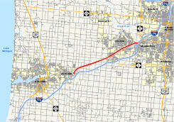
Highways in the Grand Rapids area with M-121 in redRoute information Maintained by MDOT Length: 12.763 mi[2] (20.540 km) Existed: 2007[1] – present Major junctions West end: Chicago Drive and Main Street in Zeeland East end:  I-196 in Grandville
Location Counties: Ottawa, Kent Highway system Michigan State Trunkline Highway System
Interstate • US • State←  M-120
M-120M-122  →
→M-121 is a state trunkline highway in West Michigan. The highway follows Chicago Drive, a local roadway, from Zeeland to Grandville. Chicago Drive itself runs past the M-121 segment on either from Holland to Wyoming. The roadway passes through rural farmland on a route that runs parallel to Interstate 196 (I-196). M-121 forms the main street through the center of Hudsonville as it runs southwest–northeast. It forms a major street through the unincorporated community of Jenison before M-121 terminates at I-196 in Grandville.
The M-121 designation has been used twice before in the state. The first was for a former routing of US Highway 2 (US 2), and the second was for a connection between I-69, I-75/US 23 and the airport in the Flint area. Since 2007, M-121 has been used for a portion of the former M-21 in Ottawa County, which was formerly designated as state-maintained "Old M-21". Future plans will reconfigure a section of the current highway from four lanes divided to four lanes undivided.
Contents
Route description
Chicago Drive, largely signed as M-121, is a combination state trunkline highway and municipal street running from 8th Street in Holland to the intersection of Grandville and Clyde Park avenues at the border of Grand Rapids and Wyoming, approximately 23.5 miles (37.8 km) in length. Running eastward, Chicago Drive picks up the Business Loop I-196 designation east of US 31. The highway has the typical mix of industry and commercial properties for the area. At 112th Avenue, it turns northeasterly to run through Zeeland. The roadway changes names when it turns due east again, where it is named Main Avenue and Main Place, comprising the only section of the route not designated Chicago Drive.[3]
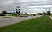 M-121 runs through Jenison's business district
Starting at the corner of Main Street and Chicago Drive, M-121 runs northeasterly out of Zeeland on Chicago Drive roughly parallel to I-196.[3] A CSX railroad line also parallels the road to the northwest.[3][4] The trunkline is a four-lane divided highway bordered by farms. Passing the Hudsonville Fair Grounds, Chicago Drive enters Hudsonville as the main street downtown. The highway continues to the northeast out of town through surburban residential areas to Jenison, where once again Chicago Drive is bordered by commercial properties. Through this area, the roadway is divided, utilizing Michigan lefts. The M-121 designation ends at the interchange with I-196 just across the Kent County line in Grandville.[3]
The corridor from I-196 to its end in Grand Rapids is lined with businesses and few houses. The intersection of Chicago Drive and Wilson Avenue is downtown Grandville. In Wyoming from north of M-11 (28th Street) to Burlingame Avenue, Chicago Drive run through a mostly industrial area with few commercial properties. Northeast of about Byron Center Avenue, Chicago Drive carries Business Spur I-196 (BS I-196). At the corner with Grandville and Clyde Park avenues, Chicago Drive ends and BS I-196 continues.[3]
M-121 is maintained by the Michigan Department of Transportation (MDOT) like other state highways in Michigan. As a part of these maintenance responsibilities, the department tracks the volume of traffic that uses the roadways under its jurisdiction. These volumes are expressed using a metric called annual average daily traffic, which is a statistical calculation of the average daily number of vehicles on a segment of roadway. MDOT's surveys in 2010 showed that the lowest traffic levels along M-121 were the 10,103 vehicles daily at the western terminus in Zeeland; the highest counts were the 20,140 vehicles per day at the eastern terminus.[5] None of M-121 has been listed on the National Highway System,[6] a network of roads important to the country's economy, defense, and mobility.[7]
History
There have been three roadways to carry the M-121 designation in Michigan.
Previous routings
M-121 was also used as the designation along two other roadways. In 1933, it was used for a former routing of US 2 in the Upper Peninsula.[8][9] In 1935, this route was redesignated as a portion of a new M-5 and the M-121 designation was transferred to Bristol Road in Flint.[10][11] This Flint-area trunline provided access to Bishop International Airport from both of the I-69 and I-75/US 23 freeways until it was retired in 2003. At that time, Bristol Road was returned to local control.[12][13]
Current routing
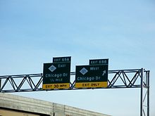 M-121's exit off I-196 in Grandville
From 1919[14] to 1926, the current highway known as M-121 was designated M-51.[15][16] Then until 1974, the trunkline was part of M-21; that designation was removed when I-196 was completed between those Zeeland and Grandville,[17][18] and much of the route became an unsigned state trunkline designated Old M-21, although it is locally referred to by its given name, Chicago Drive.[19] The portion of Chicago Drive now signed as M-121 is 12.763 miles (20.540 km) long;[2] it was given its designation in late 2007.[1]
Future
Portions of the four-lane divided surface access highway along M-121 will become four-lane undivided as the westbound lanes are shifted south away from unstable soil and parallel train tracks.[20]
Major intersections
County Location Mile[2] Destinations Notes Ottawa Zeeland 0.000 Main Street Kent Grandville 12.763 I-196Designation ends just east of the Ottawa–Kent county line 1.000 mi = 1.609 km; 1.000 km = 0.621 mi References
- ^ a b Staff (2007). "Grand Region Five-Year Transportation Program 2008–2012" (PDF). Michigan Department of Transportation. http://www.michigan.gov/documents/MDOT_5_year_Plan_Grand_143124_7.pdf. Retrieved December 7. 2007.
- ^ a b c Michigan Department of Transportation (2009). MDOT Physical Reference Finder Application (Map). Cartography by Michigan Center for Geographic Information. http://www.mcgi.state.mi.us/prfinder/. Retrieved July 26, 2009.
- ^ a b c d e Google, Inc. Google Maps – Overview Map of Chicago Drive and M-121 (Map). Cartography by Google, Inc. http://maps.google.com/maps?saddr=US-31+BUS+N%2FChicago+Dr&daddr=42.80816,-86.04781+to:42.81232,-86.01653+to:42.8339044,-85.9554022+to:Chicago+Dr+SW&hl=en&ll=42.866403,-85.88974&spn=0.484648,0.465546&sll=42.93437,-85.690269&sspn=0.060515,0.058193&geocode=FXDxjAIdxlve-g%3BFWAzjQIdvgPf-ilnKTVcJpMZiDH4veZGLijLpA%3BFaBDjQId7n3f-inXBGrQXZMZiDFrXXCZs_A_Og%3BFfCXjQIdtmzg-ilt0-TXoJUZiDHFkBDOjHSRmg%3BFY4mjwIdfoTk-g&vpsrc=6&mra=dme&mrsp=4&sz=14&via=1,2,3&t=h&z=11. Retrieved August 28, 2011.
- ^ Michigan Department of Transportation (April 2009) (PDF). Michigan's Railroad System (Map). http://www.michigan.gov/documents/MDOT_Official_Rail_130897_7.pdf. Retrieved September 14, 2010.
- ^ Bureau of Transportation Planning (2008). "Traffic Monitoring Information System". Michigan Department of Transportation. http://mdotnetpublic.state.mi.us/tmispublic/. Retrieved August 28, 2011.
- ^ Michigan Department of Transportation (2005) (PDF). National Highway System: Grand Rapids Urbanized Area (Map). http://www.michigan.gov/documents/MDOT_NHS_Grand_Rapids_150613_7.pdf. Retrieved January 1, 2011.
- ^ Adderly, Kevin (August 26, 2010). "The National Highway System". Federal Highway Administration. http://www.fhwa.dot.gov/planning/nhs/. Retrieved January 1, 2011.
- ^ Michigan State Highway Department (May 1, 1933). Official Michigan Highway Map (Map). Cartography by Rand McNally.
- ^ Michigan State Highway Department (September 1, 1933). Official Michigan Highway Map (Map). Cartography by Rand McNally.
- ^ Michigan State Highway Department (May 15, 1935). Official Michigan Highway Map (Map). Cartography by Rand McNally.
- ^ Michigan State Highway Department (June 1, 1936). 1936 Official Michigan Highway Map (Map). Cartography by Rand McNally.
- ^ Michigan Department of Transportation (2003). Official Department of Transportation Map (Map) (2003–04 ed.). Flint inset.
- ^ Michigan Department of Transportation (2004). Official Department of Transportation Map (Map) (2003–04 ed.). Flint inset.
- ^ Michigan State Highway Department (July 1, 1919). State of Michigan: Lower Peninsula (Map). Cartography by MSHD.
- ^ Michigan State Highway Department (November 1, 1926). Official Highway Service Map (Map). Cartography by MSHD.
- ^ Michigan State Highway Department (December 1, 1926). Official Highway Service Map (Map). Cartography by MSHD.
- ^ Michigan Department of State Highways and Transportation (1974). Official Highway Map (Map). 1 in:14.5 mi. Section K8–L8.
- ^ Michigan Department of State Highways and Transportation (1975). Official Transportation Map (Map). 1 in:14.5 mi/1 in:23 km. Section K8–L8.
- ^ Michigan Department of Transportation (2008). Truck Operator's Map (Map). 1 in:15 mi/1 cm:9 km. Section K8–L8.
- ^ Gonsior, Jeremy (August 28, 2007). "Redesign will change M-121 to undivided highway". Holland Sentinel.
External links
Categories:- State highways in Michigan


Wikimedia Foundation. 2010.