- Ontario Highway 402
-
Highway 402
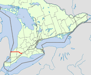
Route information Length: 102.5 km[1] (63.7 mi) History: Established: 1940s
Designated: 1952
Completed: 1982Major junctions West end: 
 I-94 / I-69 in Port Huron, MI
 Highway 40 – Sarnia
 Highway 4 – London
East end:  Highway 401 – London
Location Counties: Lambton, Middlesex Major cities: Sarnia, London Highway system Ontario provincial highways
400-series • Former←  Highway 401
Highway 403  →
→King's Highway 402, commonly referred to as Highway 402 and historically as the Blue Water Bridge Approach, is a 400-series highway in the Canadian province of Ontario which connects the Blue Water Bridge international crossing near Sarnia to Highway 401 in London. It is one of two vital trade links between Ontario and the Midwestern United States. The freeway is four-laned and controlled access for nearly its entire length, except on the approach to the Blue Water Bridge, where it widens. The only sizable community along Highway 402 between Sarnia and London is Strathroy.
Although Highway 402 was one of the original 400-series highways created in 1952, it was not completed until 1982, when the final link between Highway 81 and Highway 2 opened to traffic. Prior to 1970, the freeway did not exit Sarnia, and merged into Highway 7 near the present Highway 40 interchange.
Motorists crossing into the United States at the western end have direct access to Detroit, Chicago, and Minneapolis-St. Paul via I-94; motorists crossing onto the Canadian side from the east end of I-94 have access to Toronto via Highway 401, and on to Montreal via A-20 in Quebec.
Contents
Route description
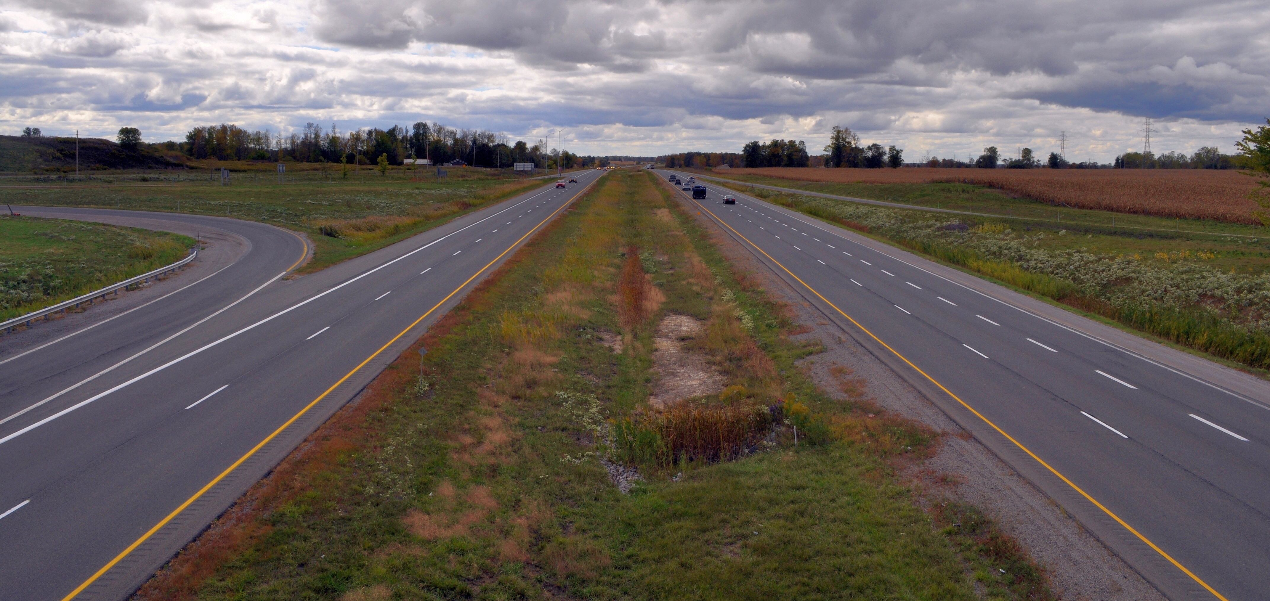
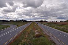 Highway 402 has a wide grass median separating its travel lanes for the majority of its length
The Blue Water Bridge crossing has 6 lanes of bridge traffic as well as non-stop freeway access,[2] giving it an advantage over the busy Ambassador Bridge crossing in Windsor, which also suffers from 13 traffic lights leading to the bridge.[3] Across the Blue Water Bridge, Highway 402 continues in Michigan as Interstates 69 and 94.[2] With the exception of the Front Street interchange in Sarnia, the freeway features Parclos throughout its length.[4] Although the freeway passes through Sarnia, it is not intended to operate as a commuter highway; the westbound lanes are signed as "Bridge to USA" instead of "Highway 402".[5]
The freeway begins on the Canadian side of the Blue Water Bridge, descending over the village of Point Edward.[6] After passing through a customs plaza, it enters Sarnia and travels parallel to and north of Exmouth Street through the city. Near the eastern limits, the freeway curves to the northeast to bypass its original alignment.[4] It crosses the Howard Watson Nature Trail, a mixed-use recreational trail that was converted from a Canadian National Railway (CNR) line in 1988 as a result of the efforts of Lambton Wildlife Inc.[7] The highway curves back to its east–west orientation as it interchanges with Highway 40.[4] It exits the city as it passes south of Sarnia Chris Hadfield Airport.[8]
Now parallel and north of London Line, the former route of Highway 7,[9] the freeway jogs north to travel along the back lot line of farmland fronting London Line and the concession road north of Highway 402.[10] In this manner, the freeway did not divide any farms when it was constructed, instead running between them. It meets Lambton County Road 21 (Oil Heritage Road), the northern terminus of the Oil Heritage Route, north of Wyoming. The county road is also a former southern extension of Highway 21, which itself begins 9.3 km (5.8 mi) to the east.[4][9] Highway 21 is also known as the Bluewater Route, as most of its length is parallel to the shore of Lake Huron.[11]
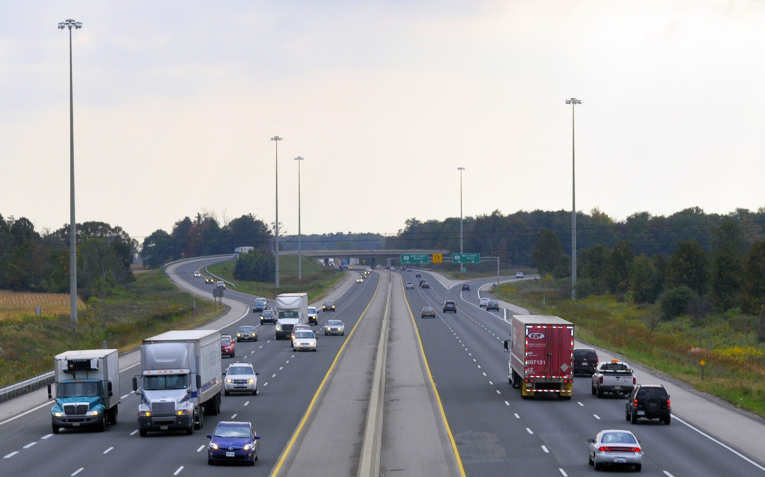
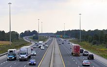 Highway 402's eastern terminus with Highway 401 in London.
The freeway crosses London Line, momentarily diverging from its straight alignment south of Warwick. It continues 25 km (16 mi) east, then interchanges with Middlesex County Road 81 (Victoria Street) as it passes north of Strathroy.[12] Shortly thereafter it curves to the southeast and zig-zags towards London, bisecting farms and dividing woodlands. The freeway passes to the west of Delaware and curves east. It enters London and meets Highway 4 south of Lambeth, interchanges with Wonderland Road and merges into Highway 401. Access to westbound and from eastbound Highway 401 is provided by Highway 4.[4]
History
Highway 402 is one of the original 400-series highways, having been numbered alongside Highway 400 and Highway 401 in 1952. The short 6.1 km (3.8 mi) dual highway was built as an approach to the Blue Water Bridge, which itself opened to traffic October 10, 1938.[13] As such, the highway was appropriately named the Blue Water Bridge Approach. Construction began in late 1938. When it was opened at some point between 1946 and 1949, it featured at-grade crossings with Front Street, Indian Road and Modeland Road (the Highway 40 Sarnia bypass).[14][15]
Construction on a new grade-separated intersection with Modeland Road began in 1963.[16] Then, in February 1968, a 98 km (61 mi) extension towards London was officially announced.[17] It was decided to construct the extension on a new alignment, as had been done with most freeways constructed after Highway 400. East of the Murphy Road overpass, Highway 402 was re-aligned to bypass the interchange with Highway 40 constructed in 1963; Exmouth Street was redirected to connect with Highway 7 (London Line) at that junction, and Quinn Street now follows the former alignment of the highway.[18] For the new Highway 402, an overpass crossing was required with the then-CNR line (now the Howard Watson Nature Trail) as well as an interchange with the newly twinned Highway 40 just north of the 1963 interchange. Construction east of Highway 40 began in 1972.[19]
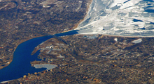 Aerial view of Highway 402 passing through Sarnia. The Blue Water Bridge is visible.
The first construction began near Highway 7, under two contracts extending 23.2 km (14.4 mi) west of there.[20] A third contract to bridge the gap between that construction and Sarnia was awarded in 1975.[21] By 1978, Highway 402 was open to traffic as far east as Highway 21, and construction was underway on the section between there and Highway 81 near Strathroy, as well as on the section connecting Highway 2 with Highway 401.[22] The section between Highway 21 and Highway 81 north of Strathroy was the next to be completed, and was opened to traffic by the end of 1979.[23] On November 17, 1981, the section between London and Delaware was completed, including the interchange at Highway 401. It forced drivers off at Longwoods Road (Highway 2). Construction was already underway on the final section between Strathroy and Delaware at this point.[24]
The completion of the Front Street interchange removed the last at-grade intersection on Highway 402, and the opening of the section between Highways 2 and 81 completed the freeway from Highway 401 to the Blue Water Bridge by 1984.[25][26]
On Monday, December 13, 2010, a whiteout caused by lake-effect snow squalls left an 80 km (50 mi) stretch of Highway 402 closed for several days. Lambton County officials declared a state of emergency. Defence Minister Peter MacKay sent two Canadian Forces Griffon helicopters to Sarnia, as well as a C-130 Hercules to aid in the search-and-rescue efforts.[27] The hospitality of locals in providing shelter for stranded motorists was the primary focus of local media coverage.[28] The highway was reopened to traffic on the morning of December 16.[29] A single death was reported; that of a man who succumbed to hypothermia on a nearby county road.[30]
Future
Highway 402 is presently being widened in the Sarnia area from four to six lanes. Due to extensive truck backups from the bridge crossing towards the USA, the westbound lanes will be widened by two lanes; eastbound capacity will remain as it is. The new four lane roadway will be divided into specific lanes for cars, trucks (two lanes), and local traffic. Construction began August 4, 2009 between the Blue Water Bridge and Lambton County Road 26 (Mandaumin Road) and includes the reconstruction of several bridges. It is expected to be completed in August 2012.[31]
Exit list
Division Location km[1] Exit[4] Destinations Notes Blue Water Bridge over the St. Clair River
 Highway 402 continues into Michigan as Interstate 94 and Interstate 69
 Lambton Point Edward 0.0 Canada–United States border 0.7 1 Front Street Formerly Highway 40B Sarnia 1.2 2 Christina Street North No eastbound exit 3.0 3 County Road 29 (Indian Road) 5.7 6 Highway 40 (Modeland Road)8.5 9 Airport Road Plympton-Wyoming 15.2 15 County Road 26 (Mandaumin Road) 24.6 25 County Road 21 / County Road 30 (Oil Heritage Road) – Wyoming Formerly Highway 21 south Warwick 34.0 34  Highway 21 north / County Road 8 (Lambton Road) – Forest
Highway 21 was concurrent with Highway 402 west to Oil Heritage Road, prior to municipal downloading in 1997 44.3 44 County Road 79 (Nauvoo Road) – Watford, Arkona Formerly Highway 79 Middlesex Adelaide-Metcalfe 55.5 56 County Road 6 (Kerwood Road) – Kerwood 64.8 65 County Road 81 (Centre Road) – Parkhill, Strathroy Formerly Highway 81 Strathroy-Caradoc 69.0 69 County Road 39 (Hickory Drive) – Strathroy 81.6 82 County Road 14 (Glendon Drive) – Mt. Brydges, Komoka 85.5 86 County Road 2 (Longwoods Road) – Melbourne, Delaware Formerly Highway 2 London 97.6 98 Highway 4 – London, St. Thomas, Lambeth99.8 100 Wonderland Road Ramps added to existing overpass, interchange opened in 1998 102.5 103 Highway 401 east – TorontoEastbound exit and westbound entrance References
- ^ a b Ministry of Transportation of Ontario (2007). "Annual Average Daily Traffic (AADT) counts". Government of Ontario. http://www.raqsb.mto.gov.on.ca/techpubs/TrafficVolumes.nsf/tvweb?OpenForm&Seq=5. Retrieved October 6, 2011.
- ^ a b "Transportation". The Corporation Of The City of Sarnia. October 24, 2007. http://www.city.sarnia.on.ca/visit.asp?sectionid=433. Retrieved February 21, 2011.
- ^ "Michigan DOT Says New Traffic Study Justifies New Detroit River Bridge". TOLLROADSNews. February 18, 2010. http://www.tollroadsnews.com/node/4611. Retrieved February 21, 2011.
- ^ a b c d e f Peter Heiler (2010). Ontario Back Road Atlas (Map). Cartography by MapArt. pp. 12–15, section T7–U17. ISBN 978-1-55198-226-7.
- ^ IBI Group (February 5, 2008). ATMS on Highway 402, Front Street to Indian Road, Sarnia: Concept of Operations (Report). Ministry of Transportation of Ontario. p. 3. http://www.highway402project-phase1.on.ca/Files/rpt_atms.pdf. Retrieved November 20, 2011.
- ^ "Tourist Information Map". Visit Point Edward. http://www.visitpointedward.com/map.html. Retrieved February 21, 2011.
- ^ "Lambton Wildlife Projects". Lambton Wildlife Inc. http://www.lambtonwildlife.com/Projects-LWI.htm#HowardWatsonNatureTrail. Retrieved February 11, 2011.
- ^ "Directions". Sarnia Chris Hadfield Airport. http://www.sarniaairport.com/directions.php. Retrieved February 21, 2011.
- ^ a b Ministry of Transportation of Ontario (January 1, 1990). Ontario Road Map (Map). Cartography by Cartography Section. Section P2.
- ^ Google, Inc. Google Maps – Satellite view of Highway 402 east of Sarnia; note its position midway between London Line and Michigan Line (Map). Cartography by Google, Inc. http://maps.google.ca/?ie=UTF8&ll=42.991967,-82.25481&spn=0.057633,0.154324&t=h&z=13. Retrieved February 21, 2011.
- ^ Whipp, Charles (1983). Road to Destiny: A History of Highway 21. Petrolia, Ontario: Lambton Editorial Associates.
- ^ "Municipality of Stathroy-Caradoc". Middlesex County. http://www.investinmiddlesex.ca/about-middlesex/municipality-of-strathroy-caradoc. Retrieved February 21, 2011.
- ^ "Construction of the Original Span". Blue Water Bridge Canada. February 22, 2008. http://www.bwba.org/original_e.html. Retrieved February 21, 2011. "After dedication ceremonies on October 7th, 8th, and 9th, the Bridge was opened for regular traffic on October 10, 1938."
- ^ Ontario Department of Highways (1946). Ontario Road Map (Map). Cartography by C.P. Robins. Sarnia inset.
- ^ Ontario Department of Highways (1949). Ontario Road Map (Map). Cartography by C.P. Robins. Sarnia inset.
- ^ Google, Inc. Google Maps – Old Modeland interchange south of current interchange (Map). Cartography by Google, Inc. http://maps.google.ca/maps?f=q&source=s_q&hl=en&geocode=&q=Modeland+Road&sll=42.988576,-82.359738&sspn=0.014001,0.027251&ie=UTF8&hq=&hnear=Modeland+Rd,+Sarnia,+Lambton+County,+Ontario&ll=42.985406,-82.343817&spn=0.014002,0.027251&t=h&z=15. Retrieved February 21, 2011.
- ^ Annual Report. Ontario Department of Highways. 1967. p. 76. http://books.google.com/books?id=LyZvE2PAjpwC&q=%22highway+402%22+Sarnia&dq=%22highway+402%22+Sarnia&hl=en&ei=S_0iTMebCcL7lwe2uvXpDQ&sa=X&oi=book_result&ct=result&resnum=2&ved=0CC8Q6AEwAQ. Retrieved February 21, 2011. "Several important freeway projects were completed including the 98-km Highway 402, Sarnia to London"
- ^ Google, Inc. Google Maps – Quinn Drive - Former Highway 402 alignment (Map). Cartography by Google, Inc. http://maps.google.ca/?ie=UTF8&hq=&hnear=Toronto,+Toronto+Division,+Ontario&ll=42.986473,-82.353773&spn=0.014001,0.027251&t=h&z=15. Retrieved June 24, 2010.
- ^ Highway Construction Program: King's and Secondary Highways. Ministry of Transportation and Communications. 1972–1973. p. xi.
- ^ Highway Construction Program: King's and Secondary Highways. Ministry of Transportation and Communications. 1975–1976. p. xi.
- ^ Highway Construction Program: King's and Secondary Highways. Ministry of Transportation and Communications. 1976–1977. p. x.
- ^ Ministry of Transportation and Communications (1978/79). Ontario Road Map (Map). Cartography by Cartography Section. Section L18–M20.
- ^ Ministry of Transportation and Communications (1980/81). Ontario Road Map (Map). Cartography by Cartography Section. Section L19.
- ^ "New Section Opens on Highway to U.S.". The Toronto Star: p. A25. November 18, 1981.
- ^ Ministry of Transportation and Communications (1982/83). Ontario Road Map (Map). Cartography by Cartography Section. Sarnia inset.
- ^ Ministry of Transportation and Communications (1984/85). Ontario Road Map (Map). Cartography by Cartography Section. Section M2–5.
- ^ McArthur, Donald; Kristy, Dylan (December 14, 2010). "Airlift Begins for Motorists Stranded on Hwy. 402 in Lambton County". The Star (Windsor). http://www.windsorstar.com/Update+Military+join+rescue+effort+motorists+stranded+weather+Highway/3972009/story.html. Retrieved December 16, 2010.
- ^ CTV.ca News Staff (December 14, 2010). "Altruistic Locals a Saving Grace for Stranded Motorists". Winnipeg: CTVglobemedia. http://winnipeg.ctv.ca/servlet/an/local/CTVNews/20101214/ontario-severe-weather-101214/20101214/?hub=WinnipegHome. Retrieved December 16, 2010.
- ^ Helms, Matt (December 16, 2010). "Canadian Highway Reopens After Snow Closure". Detroit Free Press (Michigan). http://www.freep.com/article/20101216/NEWS06/101216015/1001/news. Retrieved December 16, 2010.
- ^ Pearson, Craig (December 16, 2010). "Police say stranded Ontario driver 'succumbed to hypothermia'". The Gazette (Montreal: Postmedia Network). http://www.montrealgazette.com/news/Storm+struck+Ontario+highway+reopens+both+directions/3987163/story.html. Retrieved February 20, 2011.
- ^ Carruthers, Dale (June 10, 2010). "Highway 402 on track". The Observer (Sarnia: Sun Media). http://www.theobserver.ca/ArticleDisplay.aspx?e=2624161. Retrieved June 24, 2010.
External links
- Google Maps: Highway 402 route
- Highway 402 @ Asphaltplanet.ca
- Video of Highway 402 and Bluewater Bridge in Sarnia
Controlled-access highways of Ontario 400-series highways Other highways Current: 2A · 11 · 58 · 115 · 137 · Conestoga Pkwy. · Dougall Pkwy. · E.C. Row Expwy. · Hanlon Pkwy. · Queensway · Thunder Bay Expwy.
Municipal: Black Creek Dr. · Burlington St. · Cootes Dr. · Don Valley Pkwy. · Gardiner Expwy. · Harbour Expwy. · Highbury Ave. · Lincoln M. Alexander Pkwy. · Queensway · Red Hill Valley Pkwy. · Vets Mem. Pkwy. · W.R. Allen Rd.
Proposed: GTA West Corridor · Halton–Peel Freeway · Mid-Peninsula Highway · Bradford Bypass · West Durham Link · East Durham LinkCounty roads in Ontario · Ontario numbered highways · Expressways and 400-series highways · King's Highways · Secondary highways · Tertiary and 7000-series highways · List of Ontario provincial highways · List of former provincial highways in Ontario · Highways in Ontario · List of Ontario expressways · Trans-Canada Highway · Connecting Link · Emergency Detour RouteCategories:- 400-series highways in Ontario


Wikimedia Foundation. 2010.