Harbour Expressway

Harbour Expressway

Infobox road
highway_name = Harbour Expressway
maint = City of Thunder Bay - Department of Roads
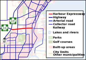


length_km = 3.5
length_round = 1
established =
direction_a = west
terminus_a = jct|state=ON|Hwy|11|Hwy|17 (Shabaqua Highway)
junction = jct|state=ON|Hwy|11|Hwy|17 (Thunder Bay Expressway)
Memorial Avenue
direction_b = east
terminus_b = Main Street

The Harbour Expressway is a four lane highway with signalized intersections running the Intercity business district of Thunder Bay, Ontario, Canada.

Thunder Bay City Council has looked at renaming the road as it doesn't fit the general definition of an expressway, but has decided that it would be unnecessary. ["TBSource " [http://www.tbsource.com/Localnews/index.asp?cid=102084 Short meeting at Council] ", 20 November 2007. Retrieved on 20 November 2007.]

Route description

The entire route of the Harbour Expressway is four lanes and undivided. Its intersections are all at-grade. Plans to divide the expressway and build interchanges are on hold, and the city of Thunder Bay maintains a right of way for these expansion plans in its official plan. In some places there is evidence of these plans.

The highway bi-sects the Intercity area which is primarily composed of big box retail stores and office parks. The road is one of the busiest in Thunder Bay.

List of intersections

The following is a list of intersections on the Harbour Expressway. The intersections on the expressway are unnumbered.

; References


Wikimedia Foundation. 2010.

Игры ⚽ Нужен реферат?

Look at other dictionaries:

  • Thunder Bay Expressway — Part of Terry Fox Courage Highway Ontario Highway 7250 …   Wikipedia

  • Cahill Expressway — Infobox Australian Road road name = Cahill Expressway route route route photo = caption = Formerly length = 2 direction = Northwest Southeast start = Bradfield Highway, The Rocks, Sydney finish = est = 1958 through = Sydney route = Sydney Harbour …   Wikipedia

  • Sydney Harbour Bridge — OperationsRoadFrom the Sydney CBD side, motor vehicle access to the bridge is normally via Grosvenor Street, Clarence Street, Kent Street, the Cahill Expressway, or the Western Distributor. Drivers on the northern side will find themselves on the …   Wikipedia

  • Colombo Harbour — Port of Colombo Location Country   …   Wikipedia

  • Sydney Harbour Tunnel — The Sydney Harbour Tunnel is a twin tube road tunnel in Sydney, Australia. The tunnel was completed and opened to traffic in August 1992 to provide a second vehicular crossing of Sydney Harbour to alleviate congestion on the Sydney Harbour Bridge …   Wikipedia

  • North Western Expressway — The North Western Expressway was a planned freeway route in Sydney, New South Wales, Australia, intended to link the Sydney CBD to its north western suburbs, and ultimately the F3 Freeway to Newcastle. The route was planned as early as 1962 (even …   Wikipedia

  • Choronology of the Malaysian Expressway System — This is a chronology of major events in the Malaysian Expressway System. Date Events Remarks 1961 Jalan Universiti and Jalan Gasing were the first dual carriageway road in Malaysia since independence. August 1965 Jalan Kinabalu flyover was the… …   Wikipedia

  • China Harbour Engineering Co Ltd — Type Limited Industry Civil Engineering Founded 2005 Headquarters …   Wikipedia

  • Northern Expressway — For the portion of U.S. Interstate 93 north of Boston also known as Northern Expressway, see Northern Expressway (Massachusetts). Northern Expressway Route information Maintaine …   Wikipedia

  • North Harbour Stadium — Location between Coliseum Drive, Albany expressway, Don McKinnon Drive and Oteha Valley Road, Albany, North Shore City Coordinates …   Wikipedia

Share the article and excerpts

Direct link
Do a right-click on the link above
and select “Copy Link”