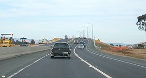
- Northern Expressway
-
For the portion of U.S. Interstate 93 north of Boston also known as Northern Expressway, see Northern Expressway (Massachusetts).
Northern Expressway Route information Maintained by Department of Transport, Energy & Infrastructure Length: 23 km (14 mi) History: Opened 13 September 2010 Major junctions Northeast end:  Gawler Bypass Road,
Gawler, Adelaidefor full list see exits and intersections. Southwest end:  Port Wakefield Road,
Waterloo Corner, AdelaideLocation Primary
destinations:Angle Vale, Andrews Farm, Macdonald Park, Penfield Highway system Highways in Australia
National Highway • Freeways in AustraliaThe Northern Expressway (route M20) is a 23 kilometre long controlled-access highway in Adelaide, South Australia. It travels from Gawler (on National Highway A20, the Sturt Highway) to Port Wakefield Road (on National Highway A1). The road has been built to four-lane standard and provides a faster route between Adelaide and Gawler, whilst reducing the amount of traffic on Main North Road, which passes through the heart of the northern suburbs and is interspersed with frequent traffic lights. It also allows freight avoid residential areas and go straight to Port Wakefield Road and onto the Port River Expressway (A9) to reach the harbour at Port Adelaide.
Contents
Construction
The largest road project undertaken in South Australia in at least sixty years, the expressway was delivered at a cost of approximately $564 million jointly funded by the South Australian and Commonwealth Governments. The Design and Construct contract was awarded to the Fulton Hogan York Joint Venture, a partnership between trans-Tasman contractor Fulton Hogan and South Australian based York Civil. The design joint venture, managed by Fulton Hogan York Joint Venture consisted of Maunsell, SMEC and Dare Sutton Clark. The work included an 8 km upgrade of the existing Port Wakefield Road. Part of the cost was covered by the AusLink national transport funding.[1]
Construction began in 2008 and the road opened on 13th September 2010.[2]
The interchanges/bridges along the expressway were all named after famous battles in which Australian forces fought, such as Long Tan, Kokoda, Tobruk and Kapyong.
Exit list
Route and Interchange list for Northern Expressway and the proposed Northern Connector. Distances are calculated from Gawler Bypass end of Expressway
Northern Expressway Northbound exits 
Distance from
Gawler Bypass Road
(km)Southbound exits 
End Northern Expressway
Merges with Gawler Bypass Road
to Mildura and Sydney
to
0 km Start Northern Expressway
from Gawler Bypass Road
Smithfield, Elizabeth
Gawler Bypass Road
_

Two Wells, Ward Belt
Two Wells Road

-- no exit Angle Vale, Kudla
Angle Vale Road

-- Angle Vale, Kudla
Angle Vale Road

Andrews Farm, Macdonald Park
Curtis Road

-- Andrews Farm, Macdonald Park
Curtis Road

Penfield, Penfield Gardens
Heaslip Road / Womma Road

-- Penfield, Penfield Gardens
Heaslip Road / Womma Road

Penfield, Virginia
Penfield Road

-- no exit ARTC INTERSTATE RAIL LINE -- ARTC INTERSTATE RAIL LINE Start Northern Expressway
from Port Wakefield Road
0 km End Northern Expressway
Merges with Port Wakefield Road
to &
&  '
'Port Wakefield, Snowtown
Port Wakefield Road


Map
Legend


 Gawler Bypass Road
Gawler Bypass Road 


Gawler West Interchange 


Two Wells Road 


Two Wells Road 


Long Tan Interchange Gawler River 


Gawler River 


Kapyong Interchange 


Angle Vale Road 


Angle Vale Road 


Kokoda Interchange Curtis Road 


Curtis Road 


Tobruk Interchange 


Womma Road Heaslip Road 


Heaslip Road 


Penfield Road 


Penfield Road 


Hamel Interchange 


ARTC Crystal Brook Line 


ARTC Crystal Brook Line 


 Port Wakefield Road
Port Wakefield Road 


Waterloo Corner Interchange 


Proposed Northern Connector
In early 2008, the South Australian Government announced plans for the Northern Connector, an eight lane connector roadway, linking the Northern Expressway and South Road.[3] This would involve the construction of a four-way cloverstack interchange at the Port River Expressway / South Road intersection.[4] This project would also include a major diversion in the main ARTC interstate rail line, which would run down the middle of the new connector freeway between Dry Creek, South Australia and Taylors Road at Waterloo Corner.
See also
References
- ^ Paul Starick (15 November 2006). "Major expressway opens up north". The Advertiser. http://www.news.com.au/adelaidenow/story/0,22606,20759351-5006301,00.html. Retrieved 2006-11-15.
- ^ Tom Zed, Transport reporter (13 September 2010). "Northern Expressway open for business". http://www.adelaidenow.com.au/news/south-australia/northern-expressway-open-for-business/story-e6frea83-1225921032131. Retrieved 2010-09-13.
- ^ "Northern Connector". Infrastructure S.A.. http://infrastructure.sa.gov.au/northern_connector/content. Retrieved 2010-06-12.
- ^ "northern connector". Infrastructure S.A.. http://infrastructure.sa.gov.au/__data/assets/pdf_file/0008/41102/Northern_Connector_Brochure_V4_June.pdf. Retrieved 2010-06-12.
External links
- http://www.northernexpressway.sa.gov.au/ Official site
 Road Infrastructure in Adelaide
Freeways Adelaide–Crafers Highway · Port River Expressway · South Eastern Freeway · Southern Expressway · Northern Expressway · Northern Connector (proposed) · South Road Superway (proposed) · North-South Corridor (proposed)
Highways and major roads Anzac Highway · Gawler Bypass Road · Glen Osmond Road · Grand Junction Road · Main North Road · Main South Road · Mount Barker Road · North East Road · Port Wakefield Road · Portrush Road · Salisbury Highway · Sir Donald Bradman Drive · South RoadOther roads City Ring Route · Cross Road · Daws Road · Fullarton Road · Goodwood Road · Greenhill Road · Hampstead Road · Kensington Road · Kings Road · McIntyre Road · Magill Road · Marion Road · Montacute Road · Montague Road · Tapleys Hill Road · The Parade · Regency Road · Torrens Road · Victoria RoadCity streets Grote Street · King William Street · Morphett Street · North Terrace · Pulteney Street · Wakefield Street · West TerraceTransport in Adelaide Categories:- Australian highways
- Roads in Adelaide
- Freeways and highways in Adelaide
- Australia road stubs
Wikimedia Foundation. 2010.


