- Port Adelaide
Infobox Australian Place | type = suburb
name = Port Adelaide
city = Adelaide
state = sa

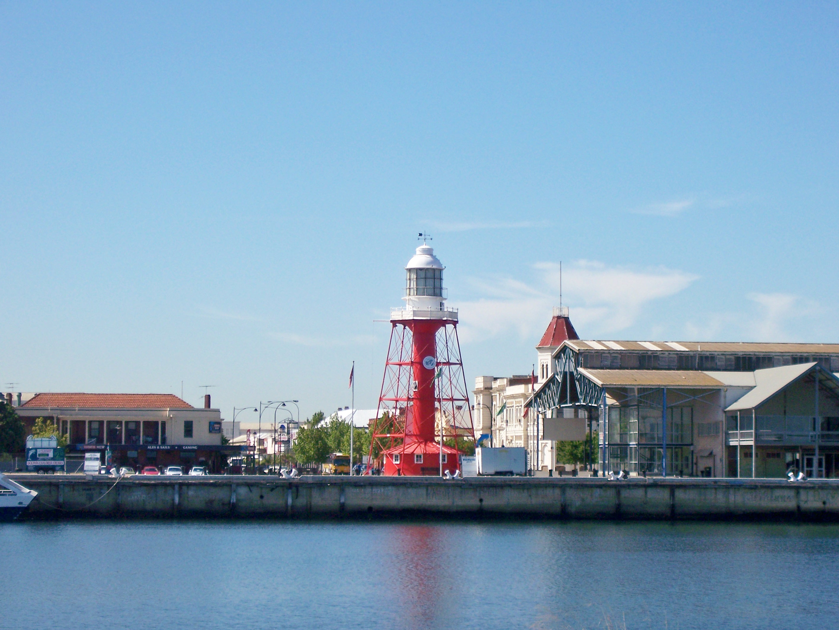
caption = View of Port Adelaide over thePort River from Birkenhead, with (L to R) Ales and Sails hotel, Port Adelaide Lighthouse and Queen's Wharf Markets visible.
lga = City of Port Adelaide Enfield
postcode = 5015
pop = 1,099 (2006) [ [http://www.censusdata.abs.gov.au/ABSNavigation/prenav/LocationSearch?locationLastSearchTerm=Port+Adelaide&locationSearchTerm=Port+Adelaide&newarea=SSC42356&submitbutton=View+QuickStats+%3E&mapdisplay=on&collection=Census&period=2006&areacode=SSC42356&geography=&method=Place+of+Usual+Residence&productlabel=&producttype=QuickStats&topic=&navmapdisplayed=true&javascript=true&breadcrumb=PL&topholder=0&leftholder=0¤taction=104&action=401&textversion=false&subaction=1 Population 2006 Census] Australian Bureau of Statistics]
area =
est = 1836
propval = $380,000 (2008) [ [http://www.domain.com.au/public/suburbprofile.aspx?mode=buy&suburb=Port%20Adelaide&postcode=5015#mapanchor Domain.com.au] 2008 Port Adelaide Property Values]
stategov = Port Adelaide
fedgov = Port Adelaide
near-nw = Peterhead
near-ne=Torrens Island
near-w=Glanville
near-e=Ottoway
near-sw=Ethelton
near-s=Queenstown
near-se=Rosewater
near-n=Birkenhead
dist1 = 14
location1= AdelaidePort Adelaide (coord|34|50|S|138|30|E|region:AU-SA_type:city) is a suburb of
Adelaide lying about 14 kilometres northwest of theCity of Adelaide . It lies within theCity of Port Adelaide Enfield and, as the name suggests, it is the mainport for the city of Adelaide. Today, some twenty operationalwharves handle much ofSouth Australia 's export produce: wines, motor vehicles, grains, ores and concentrates. It was often the first place migrants lived upon arrival in Adelaide. Fact|date=March 2008History
Port Adelaide is a very old suburb of Adelaide. It was officially proclaimed as a harbour in
1837 . Its original name, Port Misery, is said to have been adopted because it was a mosquito-infested swamp when the first settlers landed at Port Adelaide. It has also been suggested the name described the unsatisfactory handling of goods at the site. In1839 , the name was changed to Port Adelaide. Today, it still maintains the portworking-class feel but it is slowly becoming gentrified, especially along the Port River.In
1853 , Port Adelaide was the destination of the maiden voyage of the famousDutch clipper California, carrying some hundred English immigrants who arrived in what was considered record time for the periodFact|date=June 2007.To service the numerous stores and warehouses established in the area, many railway lines were built around the wharf areas and along streets, connecting to the main lines from Adelaide, which reached Port Adelaide in 1856 ["The Port Adelaide Railway System" Eardley, Gifford Australian Railway Historical Society Bulletin, July, 1970 pp 146-160] .
The suburb has many old colonial buildings, such as the
Port Adelaide Uniting Church , primarily near the wharves (St Vincent Street, Lipson Street and Divett Street), that have been placed under State heritage listing.Geography
Port Adelaide is bounded by the Port Adelaide River and Inner Harbour to the north and west, and by Webb Street and Grand Junction Road to the south. The main town is along St Vincent Street, with a residential area to the south of the train station along Commercial Road and Webb Street.
port
Port Adelaide is also home to the most successful
Australian rules football team in theSouth Australian National Football League (SANFL), thePort Adelaide Football Club . They won 34 SANFL Premierships since the league's inception in1870 , before being admitted into theAustralian Football League in1997 , consequently changing their nickname to the Power and winning an AFL Premiership in2004 . A side bearing their original nickname, thePort Adelaide Magpies Football Club , were admitted into the SANFL as a replacement side and have already won two Premierships.Developments
Port Adelaide suffered economic decline in the 1970s and 1980s primarily due to changes in maritime activity and the trends towards the
containerisation of imported and exported goods. Fact|date=March 2008The Port is currently enjoying a resurgence prompted by the Port Waterfront Redevelopment project — the largest waterfront urban development project being undertaken in South Australia over the next decade. [http://www.lmc.sa.gov.au/lmc/projects/projects_special_projects.cfm] It involves the preparation of over 50 hectares of former industrial harbour land by the South Australian Government's
Land Management Corporation (LMC) and transformation by the Newport Quays Consortium (comprisingUrban Construct and Multiplex) into a residential and commercial development that will eventually accommodate 4000–4,500 people and 2000 new dwellings. The redevelopment also involves the construction of up to 560 new marina berths in Port Adelaide's Inner Harbour. When finished this $1.5 billion project will also include six kilometres of promenades, pedestrian and cycling networks, parklands and marina berths [ [http://www.newportquays.com.au/fast_facts.html NEWPORT QUAYS ~ Fast Facts ] ]The Port Centre Coordination Group (PCCG) has been established jointly by LMC, the
City of Port Adelaide Enfield and the Newport Quays Consortium to ensure that the social and economic benefits of the redevelopment project are shared by Port Adelaide and the surrounding areas. The PCCG, using a 'place management' approach, is working with stakeholders to develop and implement strategies for the social and economic rejuvenation within the Port Adelaide.Additional development activity within Port Adelaide includes the
Port River Expressway connectingSalisbury Highway to Victoria Road onLe Fevre Peninsula via a road and rail bridge across thePort River . The road section of the project has been completed. [http://www.transport.sa.gov.au/transport_network/projects/port_xpress/index.asp] It is anticipated this project will divert heavy road transport away from the Port Adelaide Town Centre, creating an environment forurban renewal .ee also
*
List of Adelaide suburbs References
External links
* [http://www.the-port.com.au/ "The Port - It's Happening" ]
* [http://www.flindersports.com.au/about_loc_ade.htm Ports of South Australia]
* [http://www.portenf.sa.gov.au/ Port Adelaide Enfield Council]
* [http://southaustralianhistory.com.au/portadelaide.htm Port Adelaide History]
* [http://archivemaps.com/mapco/port1839/port1839.htm Map of Port Adelaide 1839. Taken From "The District Of Adelaide, South Australia, As Divided Into Country Sections. From The Trigonometrical Surveys Of Colonel Light, Late Survr. Genl." Febry 18th, 1839.]
* [http://archivemaps.com/mapco/port1852/port.htm Map Of Port Adelaide, Section 2112 B. 25th November, 1852.]
* [http://archivemaps.com/mapco/oldfolks/oldfolks.htm Old Folks Reunion. Town Hall ~ Port Adelaide. Oct 20th 1937.]
* [http://www.newportquays.com.au/index.html Newport Quays Development]
Wikimedia Foundation. 2010.
