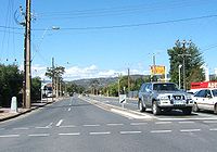
- Daws Road, Adelaide
-
Daws Road 
Daws Road, looking east from the South Road intersection Length 3 km (2 mi) Direction east-west From Goodwood Road To Marion Road Daws Road is a major double lane arterial road in the central southern suburbs of Adelaide, running east-west between Goodwood Road in the east and Marion Road in the west[1]. Daws Road crosses South Road and the Tonsley railway line. It passes under one of the two diagonal railway bridges of the Noarlunga Centre railway line, before ending at Marion Road, Ascot Park. Beyond this point, the road continues under the name Oaklands Road, heading towards Brighton Road in the west.
Daws Road travels through and borders the following suburbs:
The road is serviced by the 241 bus between Marion Road and West Street (Ascot Park), while the 213 bus runs between Beaumont Street (Clovelly Park) and Goodwood Road. The 297 bus travels from Beaumont Street to Winston Avenue (Melrose Park).
References
 Road Infrastructure in Adelaide
Freeways Adelaide–Crafers Highway · Port River Expressway · South Eastern Freeway · Southern Expressway · Northern Expressway · Northern Connector (proposed) · South Road Superway (proposed) · North-South Corridor (proposed)
Highways and major roads Anzac Highway · Gawler Bypass Road · Glen Osmond Road · Grand Junction Road · Main North Road · Main South Road · Mount Barker Road · North East Road · Port Wakefield Road · Portrush Road · Salisbury Highway · Sir Donald Bradman Drive · South RoadOther roads City Ring Route · Cross Road · Daws Road · Fullarton Road · Goodwood Road · Greenhill Road · Hampstead Road · Kensington Road · Kings Road · McIntyre Road · Magill Road · Marion Road · Montacute Road · Montague Road · Tapleys Hill Road · The Parade · Regency Road · Torrens Road · Victoria RoadCity streets Grote Street · King William Street · Morphett Street · North Terrace · Pulteney Street · Wakefield Street · West TerraceCategories:- Roads in Adelaide
Wikimedia Foundation. 2010.
