- Metropolitan Adelaide Transport Study
-
 The Conclusions and Recommendations of MATS
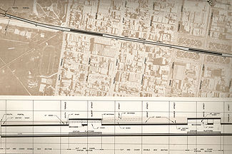
The Metropolitan Adelaide Transport Study, or "MATS Plan" as it became known, was a comprehensive transport plan released in 1968 examining the then-current and future needs of transport for the city of Adelaide.
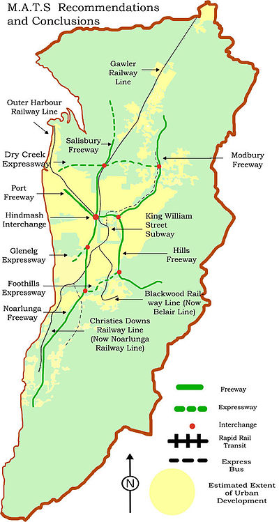
It recommended the construction of 98 kilometres of freeways, 34 kilometres of expressway, the widening of 386 kilometres of existing arterial roads, as well as new arterial roads, a new bridge over the Port River, 20 rail grade separations and heavy rail improvements including a subway under King William Street.
The estimated cost of land acquisition and construction was $436.5 million dollars in 1968, which equates to approximately $4.58 billion in 2010 with inflation.[1] Ultimately none of the plan's recommendations were brought to fruition in their original form, due to political and public opposition, in contrast to the 1969 Melbourne Transportation Plan.
In the time since the MATS plan was abandoned as a single transport package, analogous elements of the plan have been built or considered due to increasing transport pressures within greater Adelaide.
Contents
The Need For a Plan
Like other states, in South Australia there was a strong movement towards private car travel following the Second World War. Fuel rationing was a thing of the past and private car ownership was increasing.[2] The car was seen as a personal liberator, allowing people to live and travel where they pleased.
Adelaide continued to expand rapidly due to people continuing to choose to live in suburbs as well as population growth and by 1966, Adelaide's population had increased by 90% on post war levels. Experts had been warning of the consequences of unplanned urban sprawl leading to a renewed interest in planning. In 1955 the Town Planning Act was amended to make a requirement for a coordinated plan to guide the future development of Adelaide in the best interest of the community.
The Report of Metropolitan Adelaide was released in 1962 and featured proposals for the construction of freeways, but lacked detail. Experts emphasized the urgent need for road improvement including freeways warning the longer the delay, the more costly and difficult the job would become. In 1964 the South Australian Premier Thomas Playford announced the commencement of a comprehensive planning study for the future of Adelaide's transport needs. This report, titled the Metropolitan Adelaide Transportation Study (MATS) was released in August, 1968 together with an announcement that six months would be allowed for public comment before commencement of work.
Recommended Freeways
North-South Freeway
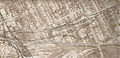
The North-South Freeway was one of the most important parts of the plan, allowing travel North and South of the linear city of Adelaide. The Report on the Metropolitan Area of Adelaide predicted Adelaide would stretch more than 70 km, from Elizabeth in the north to Sellicks Beach in the south, by the 1980s; an outcome some were keen on preventing.
Travel from Salisbury to Noarlunga would take approximately 30 minutes. The freeway consisted of two sections: the Noarlunga Freeway and the Salisbury Freeway. The Noarlunga freeway would serve the rapidly growing residential, industrial and recreational to the south connecting to major highways to Victor Harbour and Yankalilla.
Starting at Old Noarlunga, it was to follow a path adjacent to Main South Road (this has since been completed and is known as the Southern Expressway), then continuing north on a path roughly parallel to South Road then land near the west parkland with off ramps to the CBD, until joining the North Adelaide Connector. An interchange north of Anzac Highway would connect it to a proposed Glenelg Expressway along an abandoned railway corridor that still remains.
The Salisbury Freeway was the 6-lane continuation of the Noarlunga Freeway starting at the Hindmarsh Interchange then roughly followed the west of the Gawler rail line through Wingfield and north to Edinburgh. The Noarlunga Freeway was to be 8 lanes, cost $34,000,000 in land acquisition, $58,000,000 in construction and carry 93,000 cars on an average weekday by 1986.
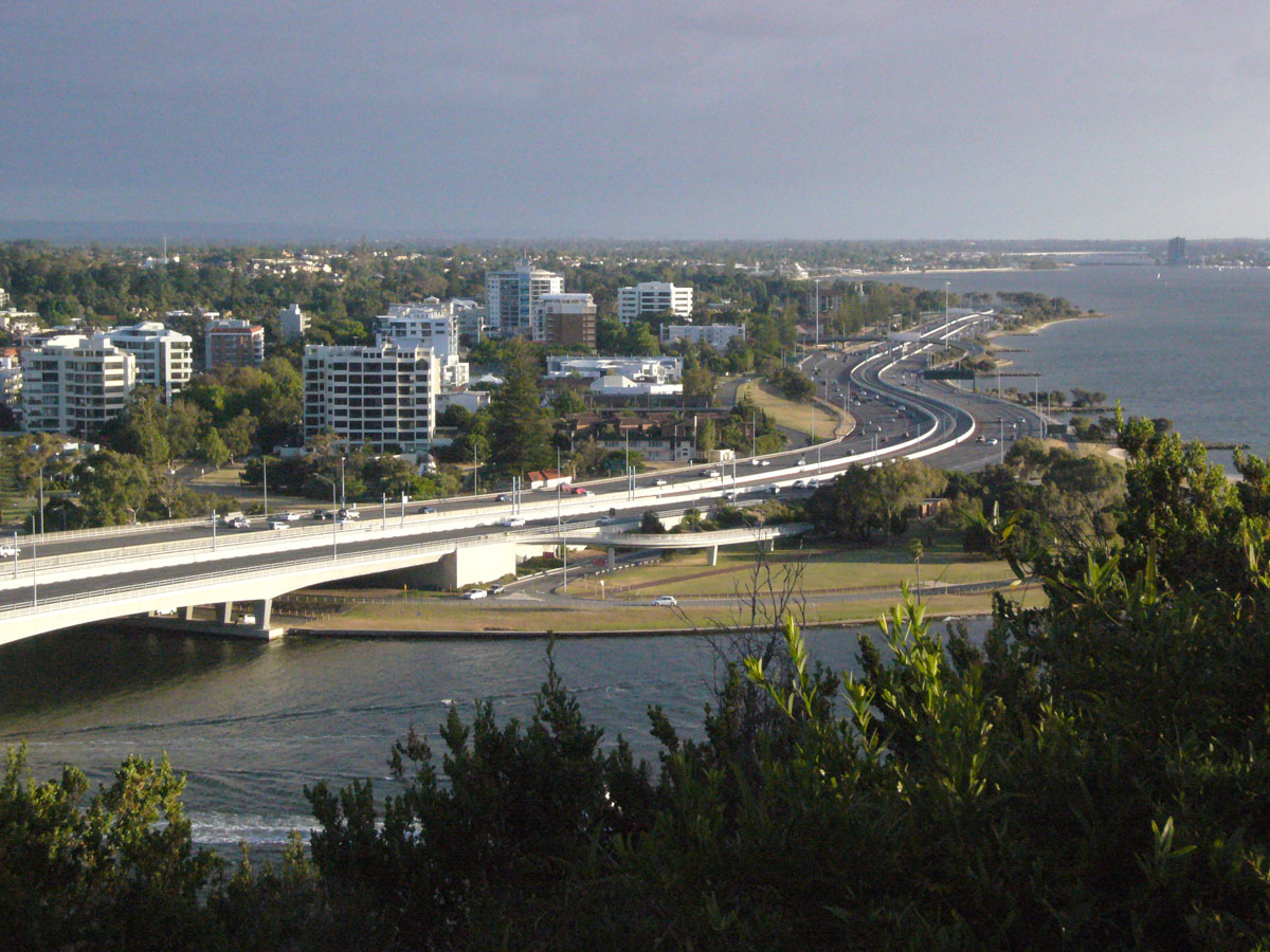
Main North Road comparably carries approximately 46,000 cars on an average weekday in 2007.[3] The Mitchell and Kwinana Freeways in Perth forming a North-South Freeway present a good example as to what a North-South Freeway might have been like in Adelaide.
Port Freeway
This was to be a freeway constructed in the wide median strip of Port Road that had been left in earlier years for a possible canal leading from Port Adelaide to the Adelaide city centre. It was to go from the Hindmarsh Interchange to the Old Port Road intersection. It would feature pedestrian overpasses but was still criticised for blocking communications across Port Road.[4] Following Port Road, Commercial Road was to continue over a new bridge over the Port River connecting to Victoria Road making a continuous arterial road.
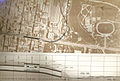
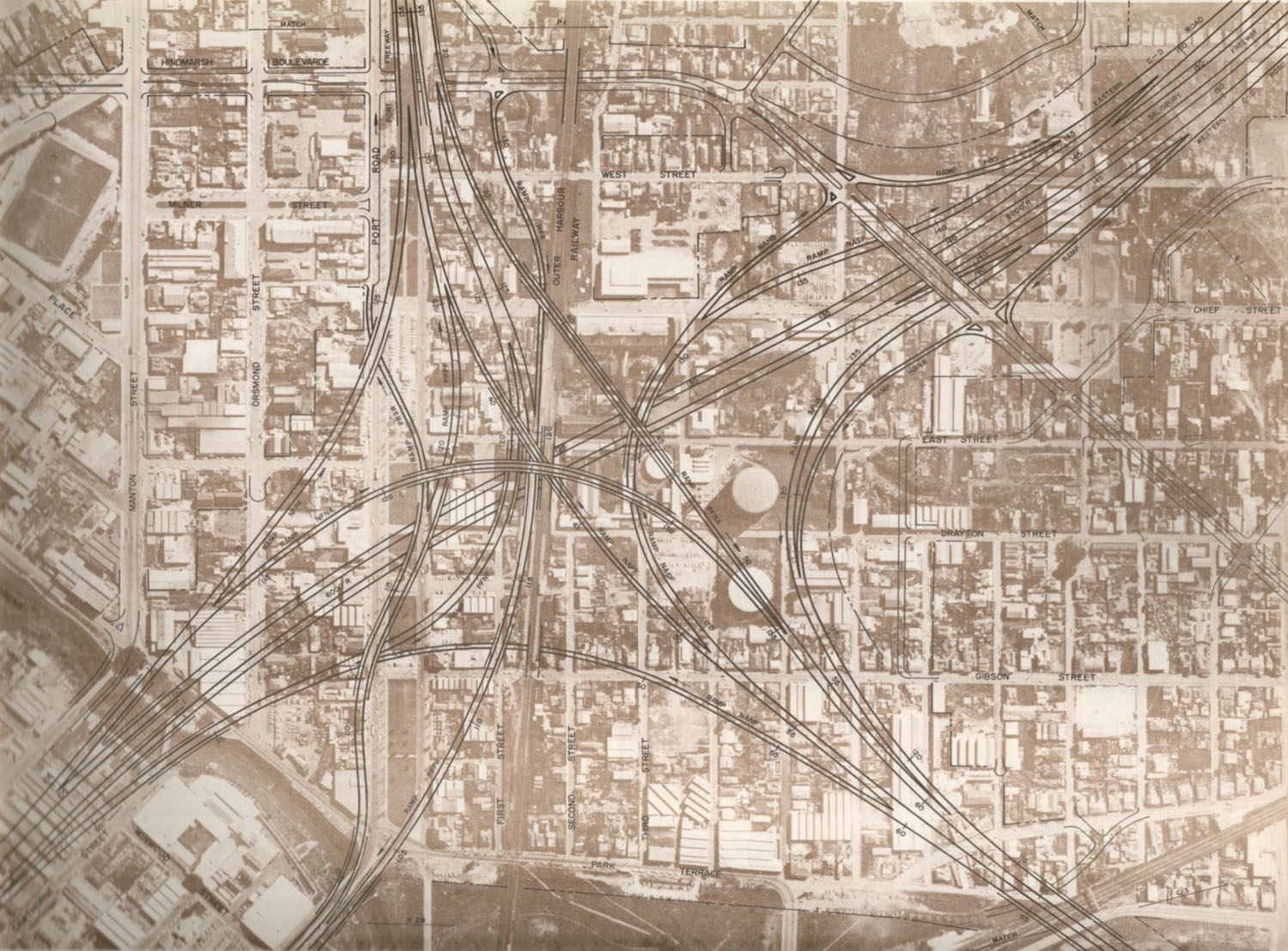
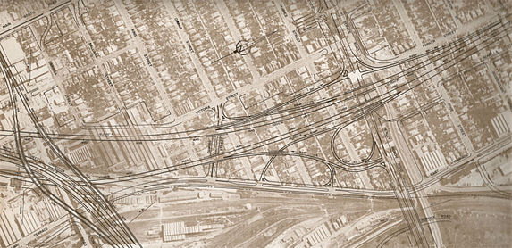
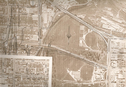
Hindmarsh Interchange
The largest construction project in the plan. The intersection of the Port Freeway, North-South Freeway and North Adelaide Connector would have required a four-level spaghetti interchange with many flyovers that would have almost engulfed the suburb of Hindmarsh. Pictures of similar sized interchanges in Los Angeles were used to good effect by opponents of MATS. There were four different designs proposed including one that was to be sited in the parklands reducing the need for land acquisition.
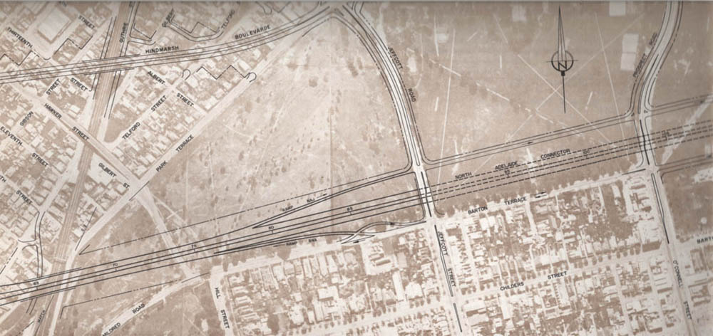
North Adelaide Connector
This was to connect the West and Eastern sides of the city starting from the Hindmarsh Interchange and connecting to the Modbury Freeway. It would have encroached upon Parkland and go partway underground to reduce the loss of open space.
Arterial road improvements have since taken place in the area, particularly on roads lining the parklands including Park Terrace, Fitzroy Terrace and Park Road. And overpass on Park Terrace over the Gawler railway line has been constructed but not over the Outer Harbor railway line.
The Hawker Street tram bridge over the Gawler Railway line was demolished in the 1970s due to lack of maintenance and safety concerns. An overpass over the Gawler railway line at Torrens Road has not been constructed as proposed but land set aside remains. A report on the Torrens Road upgrade in 2005 stated grade separation was no longer a priority.[5]
Hills Freeway
This was proposed to be a connection between the new South Eastern Freeway (then under construction) and the CBD. It would have cut a swathe through College Park, St. Peters, Norwood, Rose Park, Myrtle Bank and Urrbrae before leaving the city at Belair Road. Many of Adelaide's most affluent suburbs would have been broken up. This proved to be the most controversial part of the entire MATS plan. It was dropped from subsequent proposals but served to turn public opinion against the rest of the project.
Foothills Expressway
A proposed link between the North-South Freeway at Darlington (approximately the point where South Road meets Sturt Road) travelling in a north-east direction to meet up with the Hills Freeway at Belair Road. The expressway was scrapped from subsequent proposals with the Hills Freeway.
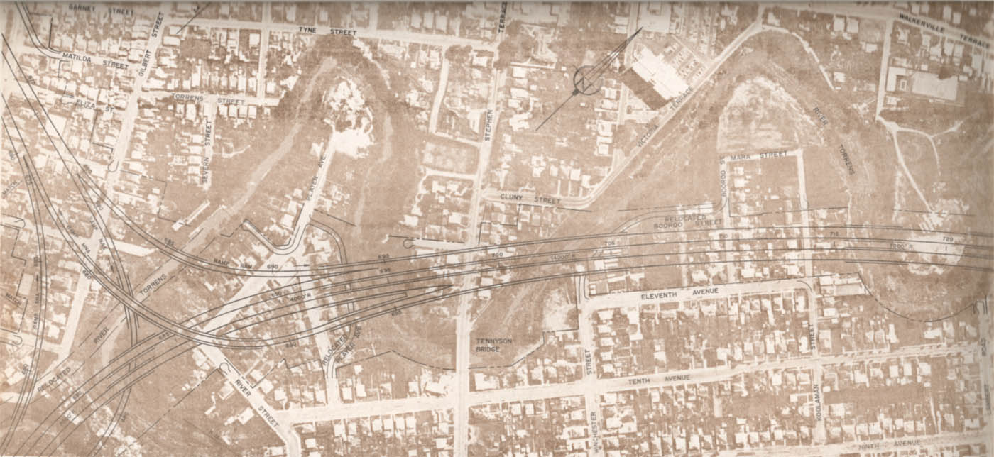
Modbury Freeway
Starting at the North Adelaide Connector, this would have followed the River Torrens along Linear Park (the O-Bahn Busway was later constructed on this corridor instead). At approximately 1 km from the O-Bahn's current terminus, Modbury, it would have then turned further north along what is now McIntyre Road through Golden Grove.
An express bus service along the freeway giving a similar service to the current O-Bahn was proposed. The freeway would have required the relocation of the River Torrens in various sections; though it was stated consideration would be given to maintain the beauty of the river.
Dry Creek Expressway
Starting at Port Adelaide, this would have been an east-west connector running roughly parallel to and slightly north of Grand Junction Road and terminating at the Modbury Freeway. The section west of Main North Road has been completed since as the Port River Expressway. However it has not been extended eastward.
Attributes Table Noarlunga Freeway Hindmarsh Interchange North Adelaide Connector Port Freeway Salisbury Freeway Hills Freeway Modbury Freeway Cost Land Acquisition 34,000,000 16,700,000 5,700,000 100,000 9,800,000 20,000,000 7,400,000 Cost Construction 58,000,000 13,000,000 11,500,000 15,100,000 14,000,000 32,000,000 42,500,000 Cost Total 92,000,000 29,700,000 17,200,000 15,200,000 23,800,000 52,000,000 49,900,000 Estimated Cars Weekday 1986 93,000 N/A 62,000 68,000 62,000 58,500 79,000 Length in Kilometres 34.4 2.6 3.2 3.3 12.7 2.9 21.2 Number of Lanes 8 N/A 6 6 6 6 8 Public Transport Changes
There were various changes to public transport proposed. Public Transport was said to be important in directing and shaping urban growth which included increasing vitality of the city centre. It would provide support for those in the community that could not drive.
The rail system was to be turned into a rapid rail network which would be aimed at providing efficient long distance, high speed suburban transport. Many existing train stations were to be closed and some to be relocated to link to main roads. Closure of stations allowed higher running speeds of trains and reduced running and maintenance costs.
Locating stations closer to main roads made them more accessible and visible. Train Stations would be supported by feeder bus services increasing the serviceable range of stations. Competing bus services were to be removed. A space of 3.2 kilometres between railway stations was said to be optimal.
The Noarlunga train line, which then only went to Hallett Cove, was to be extended to Christie Downs. The Glenelg Tramline would require additional investment to integrate with the proposed new rapid rail system, and construct grade separations along existing roads.
However its patronage was lower than competing bus routes along parallel Anzac Highway. It was said to not be cost effective to maintain the tramline. It was predicted accurately that overall public transport usage would fall to below 5% by around the year 2000, and proceeding with the recommended changes would maintain the number at 7%.
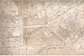
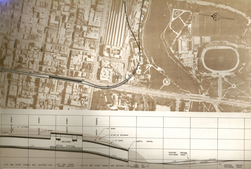
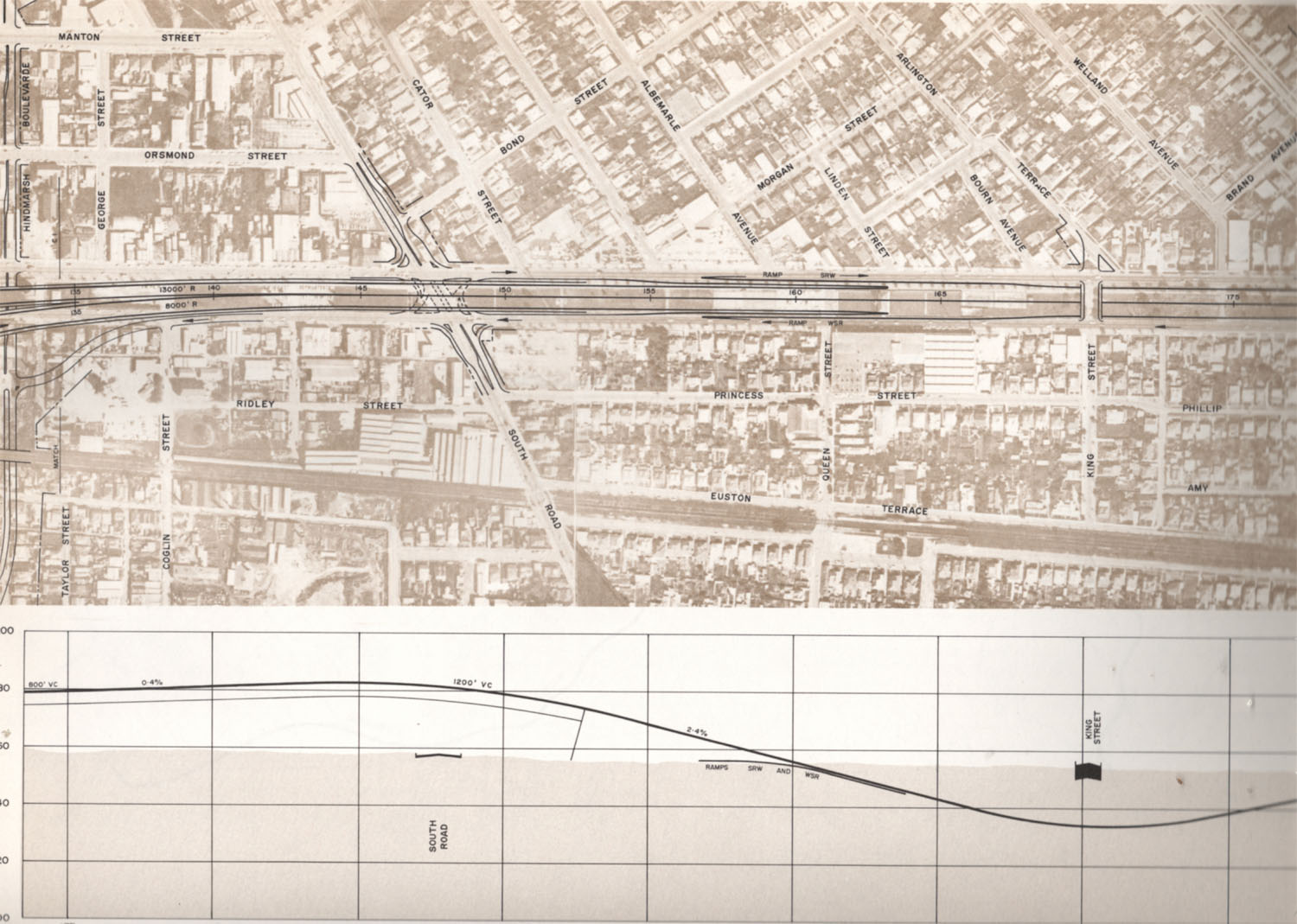
King William Street Subway
The most significant Public Transport change was a rail subway starting from the railway where the current train station is under King William Street and exiting where the current Glenelg Tram leaves South Terrace. It was said the subway would lead to increased land values and encourage development to the south side of the city; the Toronto Yonge Street Subway was used as an example. It would have been necessary to abandon Adelaide Railway Station for the subway, which would have made land around the station available for redevelopment.
The plan for the subway contained three stations throughout the city and was estimated to cost $32,000,000. A cut and cover construction technique was to be used reducing construction costs. Such a method would be unviable now due to development that has taken place since.
Reaction and Opposition
MATS became politicised as initial public reaction became a party stance. South Australians in general were opposed to freeways for various reasons. Opposition was similar to the Freeway and expressway revolts experienced in the United States. Large scale property acquisition proved to be one of the largest sources of opposition. The Noarlunga Freeway alone would have required the acquisition as many as 3,000 properties, including 817 residential dwellings. The Hills Freeway would have required the demolition of significant areas of the historic suburbs of inner south-eastern Adelaide.[6]
The impact of freeways on the urban landscape also proved to be a large source of opposition. It was feared freeways would create urban problems. People looked at cities such as the city of Los Angeles and the urban problems it experienced such as gridlocked traffic and the division of neighbourhoods leading to the creation of urban ghettos and believed the same would happen in Adelaide if freeways were constructed. The Report on the Metropolitan Area of Adelaide 1962 contained images of the city of Los Angeles and its extensive freeways to represent a potential model for Adelaide's future transport solutions.
Many believe these problems would not be created by the construction of freeways, and comparing the construction of freeways in Adelaide with the city of Los Angeles was a misrepresentation of the realities.[7] It is unlikely the construction of freeways would have led to urban problems experienced in large cities such as Los Angeles and more appropriate comparisons to cities of a similar size to Adelaide such as Calgary, Canada were not used.
Some wanted Adelaide to develop as a more European type city with high density housing and a stronger emphasis on public transport. The superintending engineer of the Highways Department attacked more extreme positions on public transport stating that it had been planned to the maximum extent that is economically feasible. He stated there was no shortfall of “instant experts” in the community who saw public transport as a solution to all urban problems, but being too long on imagination and too short on practicality.[8]
Result of MATS
In 1969 the State Cabinet with Liberal and Country League coalition as government and Steele Hall as premier approved the MATS Plan excluding some proposals which were to be further reviewed including:
- Closure of the Grange Railway line
- Foothills Expressway and Hills Freeway
- Selections of the Modbury, Noarlunga Freeways and Dry Creek Expressway
- Rerouting railway from Edwardstown to Goodwood
Abandonment
In 1970 a new Labor government under Don Dunstan was elected and shelved MATS, but did not go as far as selling the corridors already acquired in case opinion changed in the future. Dunstan proposed satellite cities such as Monarto, as well as investigating new technologies in public urban transport.[9] Dunstan attempted to construct a light rail line in the north-east along the Modbury corridor. It later turned out the O-Bahn would be constructed instead.
In 1980, the Liberal party won government on a platform of fiscal conservatism and the premier David Tonkin committed his government to selling off the land acquired for the MATS plan ensuring that even when needs or public opinion changed, the construction of most MATS-proposed freeways would be impossible. However debate continued on a North-South Freeway to replace South Road. In 1982, the Minister for Transport Michael Wilson, abandoned the idea of a high speed freeway and instead began widening South Road between Torrens Road and Daws Road as a short term solution while retaining a corridor from Dry Creek to Darlington as a concept.[6]
In June 1983, the North-South Corridor, the last surviving element of MATS, was completely abandoned as too much land had been sold off to make it practical. The abandonment had a significant impact on the Highways Department as it was the first time in its history that a government had rejected the recommendations of the Commissioner. It undermined the Department's record of independence from politics. Some of the city's current transport bottlenecks would have been reduced had the originally proposed freeways been constructed.[6]
Post-abandonment assessment
Attitudes towards MATS in the present day are mixed. The then premier Steele Hall still believed abandoning the plan was a severe mistake and has received mention in The Advertiser about the topic in recent times.[10]
MP Bob Such praised the efficiency of the South-Eastern Freeway, and he stated in parliament, "I found it quicker to get from Murray Bridge to my home at Coromandel Valley (~60km) than to get from my home to the city (~18km). That is an indication of the effectiveness of the freeway."[11] Those in support for public transport reject the plan as it is perceived it would create competition against public transport usage, and lead to urban sprawl.
Others believe varying degrees of the plan were too ruthless towards the environment and would have ruined the character of Adelaide. Some of the issues raised about the construction of freeways can now be seen to have been unlikely to have eventuated. For example, Adelaide has spread north and south instead of the inner areas becoming denser despite a lack of freeways.
Construction and motoring lobbies generally favoured the plan heavily and, periodically, refer to the rejection of the MATS plan as a lost opportunity. Major road lobby groups as of 2007 continue to call for a North-South freeway in particular with the State Government joining calls for funding under the Federal Government's AusLink Program.[12]
MATS since
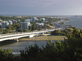
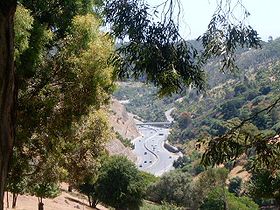
Some roads constructed since MATS are reminiscent of the original proposed freeways in MATS due to Adelaide's inherent transport pressures. The Southern Expressway has been constructed partly following the alignment the southern section of the Noarlunga freeway. It remained viable to construct as much land remained undeveloped. The South Eastern Freeway, was completed in 1979 and had partly began construction at the time of MATS. The Port River Expressway was opened in 2005, which partially follows the original Modbury to Port Adelaide ("Dry Creek") Expressway proposed by MATS but does not extend eastwards.
The Rann government stated it believes South Road should be upgraded into a non stop north-south route, but declined a 2007 $1bn pre-election funding offer from the then Howard Government, whch would have upgraded substantial sections of the road. Construction of an underpass at the intersection of South Road and Anzac highway begun in 2007 and was completed in 2009,[13] however another proposed underpass under the intersections of Grange Road, Port Road and the Outer Harbor/Grange railway line appears to has been shelved, possibly due to the substantial cost blowouts of the South Road/Anzac Highway underpass.
The same government proposes another underpass be built at the South Rd/Sturt intersection after 2010. Construction of roads has become considerably more expensive than at the time of the MATS proposal due to increasing construction and land costs. The South Road project is due to be completed by 2020.
Gallery
-
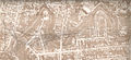
Hindmash Interchange Recommended Interchange
-
King William Street Subway North
-
King William Street Subway South
-
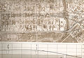
East Arterial Roads
-
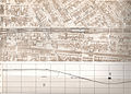
Noarlunga Freeway at Henley Beach Road
-
Noarlunga Freeway North
-

North Adelaide Connector
-
Modbury Freeway at Gilberton
-
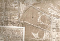
North West Adelaide
-
Port Freeway at South Road
See also
- Transport in Adelaide
- State Transport Authority
- Railways in Adelaide
- Freeways in Australia
- South Eastern Freeway
- South Road
- History of Adelaide
Melbourne:
Hobart:
- Hobart Area Transportation Study
Notes
- ^ Inflation calculator Reserve Bank of Australia
- ^ Radcliff p. 126
- ^ Transport SA: Traffic Volumes accessed 21 November 2007
- ^ Thomas Wilson, p117
- ^ Torrens Road Upgrade Final Report accessed 1 February 2008[dead link]
- ^ a b c "Adelaide’s Freeways: A History from MATS to the Port River Expressway". OZROADS. http://www.ozroads.com.au/SA/freeways.htm. Retrieved October 19, 2009.
- ^ Adelaide Transport 21 November 2007 (discussion on an Internet forum)
- ^ MATS and the Future Development of Adelaide (1968), p.22
- ^ Eric Franklin, The Advertiser: Labour Will Revise MATS Plan, 6 May 1970
- ^ The Advertiser: Adelaide Nations Traffic Basket accessed 22 February 2008
- ^ Parliament Hansard, Bob Such, Satellite City Thursday, 29 June 2006
- ^ $2 billion super road link accessed 17 July 2007
- ^ http://dtei.sa.gov.au/infrastructure/south_road_upgrade/content/anzac_highway
External links
References
De Leuw. Cather & Company. Rankine & Hill Alan M. Voorhees & Associates, 1968, Metropolitan Adelaide Transport Study 1968, Adelaide
Town Planning Committee, 1962, Report on the Metropolitan Area of Adelaide 1962, Adelaide
The University of Adelaide Department of Adult Education, the Metropolitan Adelaide Transportation Study and the Future Development of Adelaide, 1968, Adelaide
Thomas Wilson, The Relationship Between a Transport Link and Land Use Development between Adelaide and Port Adelaide South Australia, Adelaide
J.C. Radcliff. C.J.M. Steele, Adelaide Road Passenger Transport 1836 - 1958, Libraries Board of South Australia, Adelaide, 1974
Categories:- History of South Australia
- 1965 in law
- Transport in Adelaide
- History of Adelaide
- Freeways and highways in Adelaide


Wikimedia Foundation. 2010.