- Port Road, Adelaide
Infobox Australian Road
road_name = Port Road
type = road
route_
route_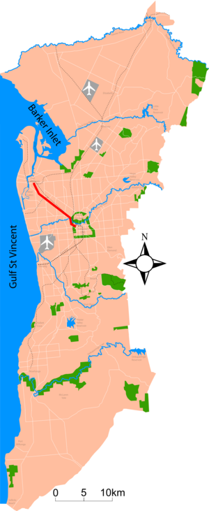
route_
photo = Port and south road.jpg
caption = Looking towards the city at the South Road intersection
length = 12
direction = southeast-northwest
start = North Terrace/West Terrace
finish = Grand Junction Road
est =
through =Adelaide , Thebarton, Hindmarsh, West Hindmarsh, Croydon, Welland, West Croydon, Allenby Gardens, Beverly, Kilkenny, Woodville Park, Woodville South, Woodville, Woodville West, Albert Park, Cheltenham, Queenstown, Alberton,Port Adelaide
route =
exits =Port Road (state route A7) is a major road in
Adelaide ,South Australia connecting the central business district withPort Adelaide [cite book|title=2003 Adelaide Street Directory, 41st Edition |publisher=UBD (A Division of Universal Press Pty Ltd) |year=2003 |isbn=0-7319-1441-4] . It is twelve kilometres (7.5mi) long and exceptionally wide. When first conceived upon the establishment of Adelaide, it was designed to be able to accommodate a standard road, a railway line and a canal. The canal and railway line were never created in the road allotment - the railway line when built in1853 was built a kilometre to the east.In the
1968 MATS plan the road was destined to be upgraded to become the "Port Freeway". The plan fell through, yet in2005 theGovernment of South Australia announced a 600m tunnel for South Road underneath Port Road and the railway line.External links
* [http://www.southaustralianhistory.com.au/portadelaide.htm South Australian History: Port Adelaide]
References


Wikimedia Foundation. 2010.