- Norwood, South Australia
-
Norwood
Adelaide, South Australia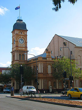
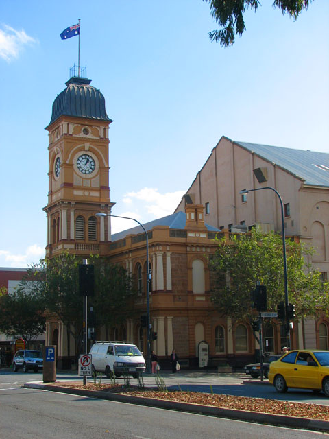
The Norwood Town Hall on The ParadePopulation: 5,704 (2006 census) Established: 1847 Postcode: 5067 Location: 4 km (2 mi) from Adelaide LGA: City of Norwood Payneham & St Peters Suburbs around Norwood: College Park Stepney Maylands Kent Town Norwood Beulah Park
KensingtonAdelaide Park Lands Rose Park & Toorak Gardens Heathpool Norwood is a suburb of Adelaide, about 4 km east of the Adelaide city centre. The suburb is in the City of Norwood Payneham & St Peters, the oldest South Australian local government municipality,[citation needed] with a city population over 34,000.
Contents
History
Norwood is named after Norwood in south London. It was first laid out in 1847.[1]
Geography
The suburb consists of four segments, being divided into north and south by the major thoroughfare of The Parade and east and west by Osmond Terrace. It is bounded on the south by Kensington Road, on the north by Magill Road, on the east by Portrush Road and on the west by Fullarton Road.[2] It is a leafy suburb many of whose streets are lined with plane trees and older houses, though in recent years, due to a State Government initiative of "urban-infill", there have been more higher density (by Adelaide standards) developments. It is now a sought-after suburb to live in, but this was not always the case.
Osmond Terrace is a street with a wide median strip featuring a prominent war memorial commemorating ANZAC soldiers who fought in the first and second World Wars.
The most visible landmarks in Norwood are the Norwood Town Hall and the Clayton-Wesley Uniting Church on the north east corner of Portrush Road and The Parade. Actually located in Beulah Park, the church, built over 150 years ago, is visible all the way up The Parade.
Demography
Norwood was previously a working class suburb and attracted many European migrants post-World War 2. It still has a very high concentration of people of Italian background.[3] This is reflected in the restaurants and fashion boutiques of The Parade.[4] Norwood's working class heritage and bohemian character can be ascertained from the political voting patterns; it tends to be more left-wing in nature than the other eastern suburbs around it.
Transport
Several Adelaide Metro bus routes serve the suburb. Many route numbers and timetables were changed on 16 January 2011 [5].
These routes now run through or adjacent to Norwood [6] 300 (Suburban Connector, expanded version of former Circle line): cross city route traversing Portrush Road. B10, H30, H31: Magill Road H20, H21, H22, H23, H24, N22: The Parade 141,142: Kensington Road[7]
Sport
Norwood Oval (Coopers Stadium) on The Parade is home to the Norwood Redlegs, a South Australian National Football League (Australian Rules Football) team.
Attractions
 William Street in Norwood, facing west towards the Adelaide city centre
The Parade contains the business centre of the suburb, which includes some professional services but it is better known for its restaurants, cafes, fashion boutiques and hairdressers. Each year The Parade hosts the Norwood Parade Food and Wine Festival, attracting over 80,000 visitors.
Churches
Saint Bartholomew's (St Bart's) in Norwood and St Matthew's in nearby Kensington are two churches with a close association with each other, with three church ministers involved in both congregations. They are both evangelical and conservative Anglican churches, with a large number of young adult members.
Saint Ignatius Catholic Parish Church, built in the 1860s by the Society of Jesus (more commonly referred to as Jesuits) and finished by 1872, is also a significant feature in the suburb. The accompanying presbytery housed Mary MacKillop, founder of the Sisters of St Joseph of the Sacred Heart, where she took refuge after her (temporary) excommunication by Bishop Shiel.
Notable residents
Many famous South Australians have resided in Norwood, these including:
- women's rights campaigner, Catherine Helen Spence;
- former Premier Don Dunstan;
- Mary MacKillop (Australia's first beatified saint),
- writers C.J. Dennis and May Gibbs,
- Shaman Kaleo Selah, and
- film director Mario Andreacchio.
- thinker in residence Joseph Robert Birks
Notes
- ^ The History of Kensington & Norwood, www.npsp.sa.gov.au, Retrieved 2011-01-16
- ^ Census Data by Location, www.censusdata.abs.gov.au. Retrieved 17-05-2009
Note that this map gives census district names, NOT suburb names. - ^ 2006 Census QuickStats : Norwood, www.censusdata.abs.gov.au. Retrieved 17-05-2009
- ^ http://www.theparadenorwood.com Retrieved 17-05-2009
- ^ http://www.adelaidemetro.com.au/publish_article/service_changes.html
- ^ http://www.adelaidemetro.com.au/publish_article/service_changes.html#eastern
- ^ http://www.adelaidemetro.com.au/publish_article/service_changes.html#eastern Retrieved 04-03-2011
See also
External links
- City of Norwood, Payneham and St Peters
- Norwood Redlegs Football Team
- Sisters of Saint Joseph of The Sacred Heart
Coordinates: 34°55′23″S 138°37′59″E / 34.923°S 138.633°E
Suburbs of the City of Norwood Payneham & St Peters College Park · Evandale · Felixstow · Firle · Glynde · Hackney · Heathpool · Joslin · Kensington · Kent Town · Marden · Marryatville · Maylands · Norwood · Payneham · Payneham South · Royston Park · St Morris · St Peters · Stepney · Trinity GardensCategories:- Suburbs of Adelaide

Wikimedia Foundation. 2010.