- Clovelly Park, South Australia
-
Clovelly Park
Adelaide, South Australia
English Avenue, looking east towards South RoadPopulation: 2,718 (2001)[1] Postcode: 5042 Area: 10.1 km² (3.9 sq mi) Location: 10 km (6 mi) from City-centre LGA: City of Marion State District: Elder, Mitchell Federal Division: Boothby Suburbs around Clovelly Park: Ascot Park Edwardstown Melrose Park Mitchell Park Clovelly Park St Marys Bedford Park Bedford Park Bedford Park Clovelly Park is an inner southern suburb of Adelaide in the local government area of the City of Marion. Before becoming an 'advanced' suburb, it was a farm and vineyard. It has a population of around 2,700. The borders are defined by Daws Road to the north, South Road to the east, Sturt Road to the south, and a combination of Percy Avenue and the Tonsley railway line to the west. It is situated approximately 20 minutes from the CBD, and about 10 minutes from Flinders University, Flinders Medical Centre and Westfield Marion.
It is the location of the (now closed) Mitsubishi plant, although this is often called Tonsley Park, due to the former name of that part of the suburb.
For a time, Clovelly Park was also referred to as Chrysler Park due to misprints on street directories labelling the train station as 'Chrysler Park' railway station and due to the presence of the Chrysler Australia car plant, which was opened in 1964 and taken over by Mitsubishi Australia in 1980.
Contents
Etymology
Clovelly Park is simply named after the village in Devon, England of the same name. The landscape of Clovelly Park at the time was similar to that of Clovelly, Devon.
History
The original inhabitants of the area, the Kaurna, lived mainly along the Sturt River which passes several hundred metres to the south of the suburbs southern boundary, Sturt Road. Richard Hamilton, whose family went on to become major wine producers in the state, planted the first vineyard in the area in 1838, just two years after the colony of South Australia was founded. Settlers followed, planting vineyards, market gardens and almond orchards around the banks of the river and the creeks further north in what was later to become Clovelly Park.
Clovelly Park is situated on former Viaduct and Watts Creek. Following World War II, Clovelly Park was opened up for limited housing and the bitumising of roads began. Prior to widespread development in the mid 1950s, Clovelly Park remained a farming and agricultural region with a large number of vinyards and almond orchards. In 1955, Chrysler Australia purchased 71 hectares (180 acres) of land in Clovelly Park and built a car assembly plant which was opened in 1964,[2] and was, at the time, the largest such operation under one roof in the southern hemisphere.
The Clovelly Park Post Office opened on 15 November 1950 and was renamed St Marys in 1967.[3]
During the 1960s, urban encroachment by the city of Adelaide enabled developers to build on the remaining farms, many bankrupted by rising land taxes and council rates. Created was a small semi-town very similar to that of modern day Sellicks Beach or McLaren Vale. The late 1960s saw Clovelly Park and most other suburbs of Marion turn into a 'family friendly' establishment due to the introduction of parks, reserves, and in the 1970s, playgrounds. This establishment although toned down, stands today.
During the 1980s, Clovelly Park opened its doors to a more retail scene, with the opening or upgrading of a few major shopping centres in surrounding suburbs. Today, Clovelly Park has lost most of its countryside charm but is still regarded as a safe family friendly neighbourhood.
Schools and childcare
 Clovelly Park Primary School, originally known as Mitchell Park Primary School, it was renamed in 1995 following the closure of Tonsley Park Primary School.[4]
The area contains a government primary school — Clovelly Park Primary School — which caters to approximately 300 students[5] and includes a New Arrivals Program (NAP) for young migrant students.[6] The nearest government secondary school is Mitchell Park's Hamilton Secondary College (formerly Mitchell Park Technical College). St Bernadette's School in St. Marys is a lower-primary Catholic school, teaching from reception to grade 5, and is located on the other (eastern) side of South Road.[7] Sacred Heart College Middle School in Mitchell Park provides Catholic schooling for boys in grades 6-9,[8] while Westminster School is an independent Uniting Church school catering for approximately 1000 students from reception to year 12, and is located in the nearby suburb of Marion.[9]
There is no kindergarten within the suburb, but Mitchell Park Kindergarten is close by, and the suburb houses an ABC Learning Centre[10] which provides childcare.
A plan to convert an existing shopping complex on South Road into an independent primary school for the Exclusive Brethren[11] was initially approved by the City of Marion's Development Assessment Panel,[12] before being successfully challenged in the Supreme Court by a local business owner.[13]
Clovelly Park Primary School houses the office of Family Life SA[14] which delivers programs and provides resources on sexuality education to schools around the state.[15]
Finally, Clovelly Park was the location of the former Marion High School, established 1955, which closed in 1996.[16] The old high school grounds were converted into a housing estate,[17] but the school hall remains as a community centre.[16]
Shopping
There are a number of retail stores lining South Road, including a local Cash Converters, a garden center and a snack bar, but there are no significant shopping centers situated within Clovelly Park. The nearest is Park Holme Shopping Centre, which is within walking distance of the residential portion of the suburb. In addition, South Road provides ready access to the CBD and to Castle Plaza in Edwardstown,[18] while Westfield Marion in Oaklands Park possesses over 300 stores[19] (with a forthcoming expansion increasing the number by an additional 90)[20] and is readily accessible by road and public transport.[21]
Parks and community halls
 Rosslyn Avenue Reserve, the largest public open area within Clovelly Park
The largest park within the suburb is Rosslyn Avenue Reserve, which sits between Rosslyn Avenue and Beverley Street at the northern end of the suburb. Rosslyn Avenue Reserve has a playground, seating and a playing area.[22]
The Clovelly Park Reserve lies between Scottish and Australian Avenues. It features a playground, a community hall, electric barbecues and tennis courts that can be hired by the general public.[22]
 Cosgrove Hall is all that remains of Marion High School.
Slightly further south, on the site of the former Marion High School, sits Cosgrove Hall — the original school hall and gymnasium.[16] The hall can be hired for a variety of purposes, and the site includes the Graham Watts Playground (completed in February 2006, and named after the long-serving local councillor),[23] a basketball net and undercover seating. The hall can be found on the corner of York Street and Scott Avenue.[22] (Officially opened September 2007). Cosgrove Hall is also the unofficial home of the National Wrestling Alliance: NWA Pro Australia NWA Pro Australia. The NWA run numerous pro wrestling events at the Hall throughout the year. The events feature the best wrestlers from across Australia, battling it out in many explosive matches. It has become a very popular attraction for people of all ages, with crowds sometimes exceeding 500 people.
On the corner of Kensington Street and Windsor Avenue, just west of Cosgrove Hall, is situated Kensington Reserve. While it doesn't possess any play equipment, it does provide seating.
Byron Avenue Reserve, which resides next to the old Clovelly Park Scout Hall on Byron Avenue, encompasses 0.49 hectares which are in the process of being revegetated with pre-European flora.[24] The reserve contains 200 year old river red gums, and used to include Viaduct Creek before the creek was built over as part of the Chrysler/Mitsubishi development.[25]
Finally, hidden behind units on Cohen Court and the southern end of Windsor Avenue is a small reserve containing seating and a playground.
Although not located in Clovelly Park, the adjacent Mitchell Park Reserve on Bradley Grove provides a full-sized playing oval, a community hall, tennis courts, barbecues, large open spaces and two playgrounds.[26]
Health and community services
The Southern Clinic provides health services for the area, with six medical doctors on staff. The clinic is open Monday to Saturday, and out-of-hours appointments can be organized for Sundays. Counseling and related services are available through the Inner Southern Community Health Service [1], which includes the Aboriginal Health House on the corner of Wingfield Street and Newton Avenue. More serious cases are handled at the Flinders Medical Centre, which is a short drive away and directly accessible by public transport.
Clovelly Park Pharmacy sits alongside the Southern Clinic and the Community Health Service on South Road.
Notable residents
- Robert Coulthard, local doctor and Member of the Order of Australia.[27]
- Shaun Micallef, comedian, ARIA award winner and host of Talkin' 'bout Your Generation.
Transport
 Street in Clovelly Park, looking west from South Road
The suburb lies adjacent to South Road to the east, and Marion Road lies a short distance to the west. South Road is the main north-south arterial road in Adelaide, and thus it provides rapid access to a large portion of the city. Limited east-west travel is facilitated through Daws Road/Oaklands Road to the north and Sturt Road to the south.
Clovelly Park is well serviced by public transport. Frequent buses run along South Road, and both the 213 and 297 run through the center of the suburb. In addition, the northern residential portion of Clovelly Park is serviced by the Mitchell Park railway station on the Tonsley railway line. Clovelly Park railway station primarily services the southern portion of Mitchell Park and Mitsubishi's Tonsley plant, while Tonsley station handles the southern end of the suburb, as well as being in walking distance of Flinders University. The Noarlunga Centre railway line, which provides more services than the Tonsley line, is close by and is accessible via the Ascot Park railway station to the north of the suburb.
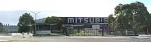 The disused Mitsubishi plant in the suburb
According to the 2006 census by the Australian Bureau of Statistics, just under 11% of the employed population of the suburb used public transport to travel to work,[28] up from 9% in the 2001 census. The majority (68%) of those traveling to work using a single form of transport relied on cars, motorbikes and trucks, with 7% of those employed choosing to travel as a passenger.
Politics
The suburb is part of the federal seat of Boothby led by Andrew Southcott and the state seats of Elder and Mitchell.
References
- ^ Australian Bureau of Statistics (19 November 2002). "Community Profile Series : Clovelly Park (State Suburb)". 2001 Census of Population and Housing. http://www.censusdata.abs.gov.au/ABSNavigation/prenav/ProductSelect?newproducttype=Community+Profiles&collection=Census&period=2001&areacode=SSC41251&breadcrumb=LP¤taction=201&action=401. Retrieved 30 June 2007.
- ^ New Plant Built in Record Time, The Advertiser, Friday, 2 October 1964, page 26
- ^ Premier Postal History. "Post Office List". Premier Postal Auctions. https://www.premierpostal.com/cgi-bin/wsProd.sh/Viewpocdwrapper.p?SortBy=SA&country=. Retrieved 2011-05-26.
- ^ Donley, R. J. R (2001). Marion 1945 — 2000: A Suburban City. Norwood, South Australia: Peacock Publishers. ISBN 1-876087-52-8.
- ^ "Clovelly Park Primary School". South Australian Government: Department of Education and Children's Services. http://www.decs.sa.gov.au/locs/a8_publish/modules/locations/school_detail.asp?id=0932&type=AZ. Retrieved 4 July 2008.
- ^ "South Australia's Curriculum Portal: New Arrivals Program". South Australian Government: Department of Education and Children's Services. 13 June 2008. http://www.decs.sa.gov.au/curric/pages/ESL/nap/?reFlag=1. Retrieved 4 July 2008.
- ^ "Find a School: St Bernadette's School". Catholic Archdiocese of Adelaide: Catholic Education. http://www.adelaide.catholic.org.au/sites/CatholicEducationOfficesSA/our-schools/find-a-school?id=2309. Retrieved 4 July 2008.
- ^ "Find a School: Sacred Heart College Middle School". Catholic Archdiocese of Adelaide: Catholic Education. http://www.adelaide.catholic.org.au/sites/CatholicEducationOfficesSA/our-schools/find-a-school?id=2236. Retrieved 4 July 2008.
- ^ "About Our Schools: Westminster School". The Association of Independent Schools of South Australia. http://www.ais.sa.edu.au/html/about_schools.asp. Retrieved 5 July 2008.[dead link]
- ^ "Clovelly Park Child Care Centres". ABC Learning Centres. http://www.childcare.com.au/centres/south-australia/adelaide/clovelly-park. Retrieved 5 July 2008.
- ^ Todd, Adam (27 November 2007). "Brethren conversion". Guardian Messenger. http://www.messengernews.com.au/article/2007/11/27/3029_south_news.html. Retrieved 20 January 2008.
- ^ "Development Assessment Panel Minutes (12/05/2007)". City of Marion. 5 December 2007. http://www.marion.sa.gov.au/web/MinAgCou.nsf/4d29600910fc1995e9256e16001a74d6/6078722e2e4267f6e92573ae007e8107/$FILE/Minutes_signed_DAP_5%20December%202007.pdf. Retrieved 20 January 2008.[dead link]
- ^ Garvis, Sarah (4 June 2008). "School rejected". Guardian Messenger.
- ^ "Contact Us". Family Life SA. http://www.decs.sa.gov.au/family/pages/default/welcome/?reFlag=1. Retrieved 5 July 2008.[dead link]
- ^ Peters, Barry (17 June 2005). "Survey shows the need for sex education". The Advertiser.
- ^ a b c "Plaque marks slice of history". The Advertiser. 21 November 2002.
- ^ "Land Review; Marion still earning top marks". Sunday Mail. 15 March 1998.
- ^ "Getting There". Castle Plaza. http://www.castleplazashopping.com.au/gettingthere/. Retrieved 5 July 2008.
- ^ "Property Portfolio: Westfield Marion". Westfield Group. http://westfield.com/corporate/property-portfolio/australia/marion.html. Retrieved 5 July 2008.
- ^ Todd, Adam (21 August 2007). "Marion thinks big". Messenger Community News. http://www.messengernews.com.au/article/2007/08/21/1937_south_news.html. Retrieved 5 July 2008.
- ^ "Getting here". Westfield Marion. Archived from the original on 16 June 2008. http://web.archive.org/web/20080616113617/http://westfield.com/marion/gettinghere/index.html. Retrieved 5 July 2008.
- ^ a b c "Reserves and Open Space". City of Marion. Archived from the original on 11 January 2008. http://web.archive.org/web/20080111035754/http://www.marion.sa.gov.au/web/webmar.nsf/lookup/Reserves+and+Open+Space!OpenDocument&ExpandSection=3#_Section3. Retrieved 5 July 2008.
- ^ Todd, Adam (12 September 2007). "Sliding into history". Guardian Messenger.
- ^ "For Life On Earth: Council care from the hills". Sunday Mail. 3 June 2001.
- ^ "Byron Ave Reserve". City of Marion. http://www.marion.sa.gov.au/web%5Cwebmar.nsf/lookup/Byron+Ave+Reserve. Retrieved 2 February 2008.[dead link]
- ^ "Reserves and Open Space". City of Marion. Archived from the original on 11 January 2008. http://web.archive.org/web/20080111035646/http://www.marion.sa.gov.au/web/webmar.nsf/lookup/Reserves+and+Open+Space!OpenDocument&ExpandSection=11#_Section3. Retrieved 5 July 2008.
- ^ Michelmore, Karen (26 January 1998). "Australia Day Honors 1998; Far-sighted doctor has vision for the future". The Advertiser. (Resides in Belair, South Australia but practices at the Southern Cross Clinic in Clovelly Park).
- ^ Australian Bureau of Statistics (25 October 2007). "Community Profile Series : Clovelly Park (State Suburb)". 2006 Census of Population and Housing. http://www.censusdata.abs.gov.au/ABSNavigation/prenav/ProductSelect?newproducttype=Community+Profiles&collection=Census&period=2006&areacode=SSC41266&breadcrumb=LP¤taction=201&action=401. Retrieved 30 June 2007.
Suburbs of the City of Marion Ascot Park · Bedford Park · Clovelly Park · Darlington · Dover Gardens · Edwardstown · Glandore · Glengowrie · Hallett Cove · Marino · Marion · Mitchell Park · Morphettville · O'Halloran Hill · Oaklands Park · Park Holme · Plympton Park · Seacliff Park · Seacombe Gardens · Seacombe Heights · Seaview Downs · Sheidow Park · South Plympton · Sturt · Trott Park · WarradaleCategories:- Suburbs of Adelaide


Wikimedia Foundation. 2010.