- Cootes Drive
-
Cootes Drive
Highway 8D, Highway 102 Route information Length: 3.5 km (2.2 mi)
(1963)Existed: 1936 (as Highway 8D) – 1964 (as Highway 102) Major junctions West end: York Boulevard East end:  Main Street (formerly Highway 2)
Location Major cities: Hamilton, Ontario Highway system Cootes Drive, formerly known as the Dundas Diversion, is a city street in Hamilton, Ontario. The route connects York Boulevard and King Street in Dundas with Highway 2 and Highway 8 to the southeast, and is considered the first divided highway in Canada.
Contents
Route description
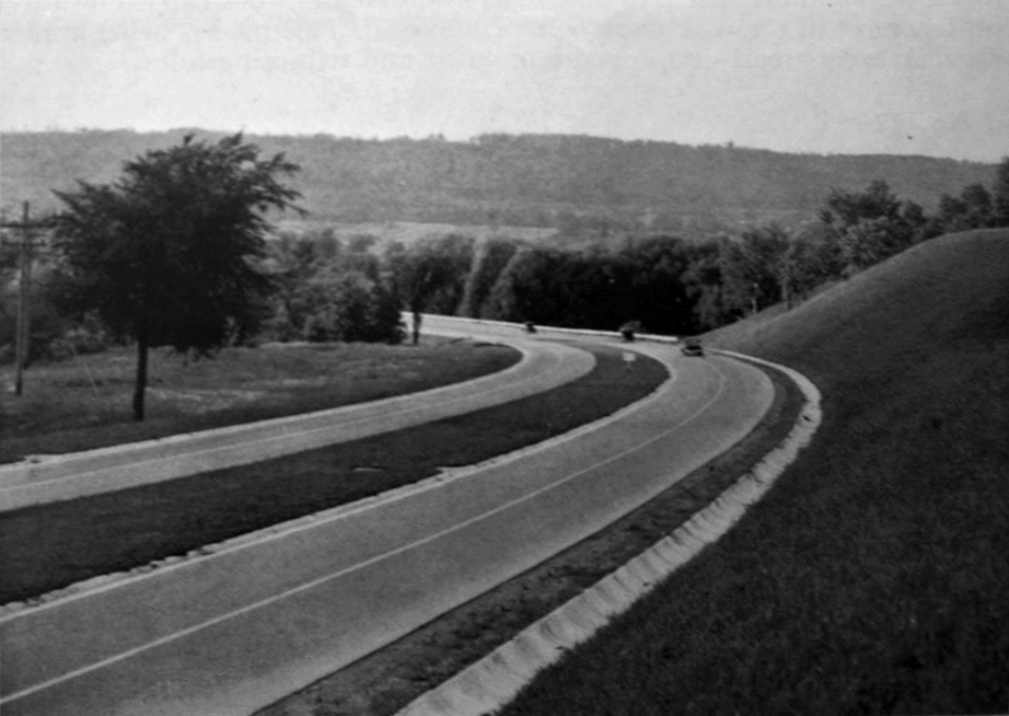
 The newly completed Dundas Diversion, 1937
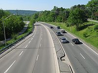 Similar angle, 2007
Cootes Drive travels from Main Street West (former Highway 2 and Highway 8), past McMaster University, through Cootes Paradise to the former town Dundas, where it feeds into King Street.
There is a shared pedestrian and bicycle path along its length, and GO Transit operate two regional coach routes from their McMaster University GO Bus Terminal on the east side of Cootes Drive, at the edge of the university’s campus.
History
The Dundas Diversion was the first divided dual-carriageway road built in Canada; completed in 1936,[1] it predates the nearby Queen Elizabeth Way, which was still under construction at the time, with the name of ‘Middle Road’.
Cootes Drive is now signed as Hamilton Road 8. It was originally designated 8D (indicating that it was a diversion of Highway 8), then changed to the designation of Highway 102 in 1947, before being turned back to local authorities in 1964. The Highway 102 designation has since been reused on a different highway near Thunder Bay.
See also
References
Roads and streets in Hamilton, Ontario Lower City Arteries
(Primary)Aberdeen • Barton • Bay • Burlington • Centennial • Cootes • Dundurn • Gage • James • John • Kenilworth • King (Hamilton) • King (Dundas) • Main • Ottawa • Parkdale • Queen • Queenston • Victoria • Wellington • Wentworth • Woodward • YorkLower City Collectors
(Secondary)Mountain-access roads Beckett Drive • Claremont Access • Highway 20 • Highway 403 • James Street Access • Jolley Cut/ Arkledun Ave. • Kenilworth Access • Mount Albion • Red Hill Valley Parkway • Sherman Access • Upper Centennial ParkwayUpper City Arteries Concession • Fennell • Garth • Mohawk • Mountain Brow • Mud • Rymal • Stone Church • Upper Gage • Upper James • Upper Kenilworth • Upper Ottawa • Upper Paradise • Upper Sherman • Upper Wentworth • Upper Wellington • West 5th • Wilson (Ancaster)Upper City Collectors Municipal Expressways: Burlington • The Linc • Red Hill ValleyProvincial Highways Former Provincial Highways Numbered City Roads
(Formerly Regional Roads)5 • 8 • 20 • 56 • 65 • 97 • 99Former Numbered
Regional Roads2 • 52 • 53 • 203 • 216 • 222 • 223 • 243 • 248 • 253 • 260 • 299 • 305 • 330 • 331 • 341 • 344 • 364 • 399 • 411 • 412 • 424 • 425 • 430 • 434 • 445 • 450 • 455 • 458 • 501 • 503 • 508 • 528 • 535 • 551 • 597 • 610 • 613 • 614 • 622 • 626 • 633 • 634 • 637 • 639 • 640Roads in Ontario Controlled-access highways of Ontario 400-series highways Other highways Current: 2A · 11 · 58 · 115 · 137 · Conestoga Pkwy. · Dougall Pkwy. · E.C. Row Expwy. · Hanlon Pkwy. · Queensway · Thunder Bay Expwy.
Municipal: Black Creek Dr. · Burlington St. · Cootes Dr. · Don Valley Pkwy. · Gardiner Expwy. · Harbour Expwy. · Highbury Ave. · Lincoln M. Alexander Pkwy. · Queensway · Red Hill Valley Pkwy. · Vets Mem. Pkwy. · W.R. Allen Rd.
Proposed: GTA West Corridor · Halton–Peel Freeway · Mid-Peninsula Highway · Bradford Bypass · West Durham Link · East Durham LinkCounty roads in Ontario · Ontario numbered highways · Expressways and 400-series highways · King's Highways · Secondary highways · Tertiary and 7000-series highways · List of Ontario provincial highways · List of former provincial highways in Ontario · Highways in Ontario · List of Ontario expressways · Trans-Canada Highway · Connecting Link · Emergency Detour Route Categories:- Roads in Hamilton, Ontario
- Limited-access roads
- Parkways in Ontario
- Ontario road stubs

Wikimedia Foundation. 2010.