- Golden Horseshoe
Infobox Settlement
official_name = The Golden Horseshoe
nickname =
settlement_type = Inner Ring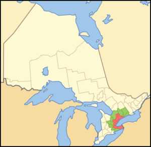
mapsize = 250px
map_caption = Location of the Golden Horseshoe in Ontario.
██ The inner ring ██ The outer ring
subdivision_type = Country
subdivision_name = flagicon|CanadaCanada
subdivision_type1 = Province
subdivision_name1 = flagicon|OntarioOntario
area_magnitude =
unit_pref =
area_footnotes =
area_total_km2 = 31561.57
area_total_sq_mi =
area_blank1_title = Outer Ring
area_blank1_km2 = 21464.12
area_blank1_sq_mi =
area_blank2_title = Inner Ring
area_blank2_km2 = 10097.45
area_blank2_sq_mi =
population_as_of = 2006
population_footnotes =
population_note =
population_total = 8102163
population_density_km2 = 256.7
population_blank1_title = Outer Ring
population_blank1 = 1614101
population_blank2_title = Inner Ring
population_blank2 = 6488062timezone = EST
utc_offset = −5
timezone_DST = EDT
utc_offset_DST = −4
postal_code_type = Postal code prefixes
postal_code = K, L, M, N
area_code = 226, 289, 416, 519, 647, 705, 905The Golden Horseshoe is a densely populated and industrialized region (or
urban agglomeration ) centred around the western end ofLake Ontario inSouthern Ontario ,Canada , with outer boundaries stretching south toLake Erie and north toGeorgian Bay . Most of it is also part of the Windsor-Quebec City corridor. With a population of 8.1 million people, it makes up slightly over a quarter (25.6%) of the population of Canada and contains approximately 75% of Ontario's population,cite web
url=http://www12.statcan.ca/english/census06/analysis/popdwell/subprov4.cfm#ggh
title=Portrait of the Canadian Population in 2006: Subprovincial population dynamics, Greater Golden Horseshoe
work=Statistics Canada , 2006 Census of Population
date=2007-03-13
accessdate=2007-03-13] making it one of the largest population concentrations in North America. Although it is a geographically named sub-region of Southern Ontario, Greater Golden Horseshoe is more frequently used today to describe the metropolitan regions that stretch across the area in totality.The core of the region, or Inner Ring, starts from Niagara Falls at the eastern end of the
Niagara Peninsula and extends west, wrapping around the western end of Lake Ontario at Hamilton and then turning northeast to its anchor cityToronto (on the northwestern shore of Lake Ontario), before finally terminating at Oshawa, just east of Toronto. The wider region, or Outer Ring, spreads inland in all directions away from the Lake Ontario shoreline, southwest to Brantford, west to theKitchener-Waterloo area, north to Barrie, and northeast to Peterborough. The whole region's area covers approximately 33,500 km², out of this, 7,300 km² is covered by the Greenbelt.University of Toronto business professorRichard Florida has labelled a segment of the region as "Torbuffchester", which stretches fromToronto through Buffalo to Rochester.cite web
url=http://www.newsweek.com/id/124550/page/1
first=Katie
last=Paul
title=What Does Your City Say about You
work=Newsweek
date=2008-03-21
accessdate=2008-03-21]The phrase, "Golden Horseshoe," was first used by Westinghouse President, Herbert H. Rogge, in a speech to the Hamilton Chamber of Commerce, on
January 12 ,1954 :cquote|Hamilton in 50 years will be the forward cleat in a 'golden horseshoe' of industrial development from Oshawa to the Niagara River...150 miles long and convert|50|mi|km wide...It will run from Niagara Falls on the south to about Oshawa on the north and take in numerous cities and towns already there, including Hamilton and Toronto.cite web| title = Fast Facts from Hamilton's Past| url=http://www.myhamilton.ca/myhamilton/LibraryServices/Localhistory/Fast+Facts.htm| accessdate = 2007-01-08] The speech writer who actually penned the phrase was Charles Hunter McBain, executive assistant to five Westinghouse presidents including Rogge.Definition
Golden Horseshoe was used as a geographical distinction since the 1950s, but it was only on
July 13 ,2004 that a report from the provincial Ministry of Public Infrastructure Renewal entitled "Places to Grow" coined the term Greater Golden Horseshoe, extending the boundaries west to Waterloo Region, north to Barrie, and northeast to Peterborough. [cite web|url=http://www.pir.gov.on.ca/userfiles/HTML/cma_4_35657_1.html|title=Places to Grow|accessdate=2006-09-13] A subsequent edition releasedFebruary 16 ,2005 , broadened the term further, adding Brant, Haldimand and Northumberland Counties.Statistics Canada defined the region first in its 2001 census as the Extended Golden Horseshoe, combining many CMAs. The Greater Golden Horseshoe is officially designated in Ontario Regulation 416/905 [ [http://www.e-laws.gov.on.ca/DBLaws/Source/Regs/English/2005/R05416_e.htm Ontario Statutes and Regulations] ] under the Places to Grow Act.Demographics
The population of the Greater Golden Horseshoe is 8.1 million residents as of the 2006 census.
The region is projected to grow to 11.5 million people by 2031 [http://209.85.173.104/search?q=cache:my_qDfxctlMJ:www.york.ca/NR/rdonlyres/5qxh6awtn7uhxfracmlvcxj5ojohfsjdc7o5etdrs7pgxwyxcdbr53gwcu7dumprack3uujv77fblpfaibktifgiue/(Growth%2BManagement)%2BPresentation%2B-%2BGTAH%2BForecast.pdf+golden+horseshoe+11.5&hl=en&ct=clnk&cd=4] . The definition of the Golden Horseshoe as an agglomerated urban area, that is combining Census Metropolitan Areas is similar to how population counts are tabulated for
Combined Statistical Area which are used in the United States to combine more than one metropolitan area, defined as an (MSA), into a larger overall urbanized area. These metropolitan areas are intrinsically linked through inter-dependence of services, trade, transportation corridors, close proximity and other factors, in this context they can also be viewed as a singleRegion . In terms of population, the Greater Horseshoe is the 6th most populated greater urbanized area in North America just behind the Baltimore-Washington-Northern Virginia CSA.Economy
The economy of this region is very diverse. Toronto's stock exchange is the third largest on the continent by market capitalization (after the NYSE and
NASDAQ ), and seventh largest in the world [http://www.2ontario.com/welcome/bcfs_400.asp] . Recently, five major office-dominated skyscrapers have been planned in its financial district (to go along with hundreds of condominiums).Niagara Falls has one of the world's largest per-capita tourist economies, benefiting from millions of tourists coming to see its majestic waterfalls and shop in its numerous stores. The wine making and fruit growing industries of the
Niagara Peninsula produce award-winning wines which are beginning to attract attention around the world, in particular theice wine for which the region is known.Cities such as Hamilton, Oshawa, Oakville, Whitby and Kitchener all contain major large-scale industrial production facilities, Hamilton being steel-dominated and Oshawa being much more car-oriented. Other significant auto-production facilities also exist in Brampton, St. Catharines, Cambridge and Alliston. Hamilton and Toronto also have two of the largest seaports in
Lake Ontario . TheWelland Canal system handles tanker ship and recreational traffic through the Great Lakes. Large rail and truck distribution facilities are located in Toronto, Vaughan and Brampton. As of 2008, however, the manufacturing sector of this region has begun to experience a significant decline in as a result of unfavourable currency exchange rates, high energy costs, and reduced demand from the United States.Lester B. Pearson International Airport, located in Mississauga is the busiest Canadian Airport handling approximately 30 million passengers a year. Other regional airports of significance include
John C. Munro International Airport south of Hamilton which is a major regional freight and courier location;Buttonville Airport andToronto Island Airport in theGreater Toronto Area both mostly serve regional business travellers andRegion of Waterloo International Airport serving the Region of Waterloo Area. On the US side,Buffalo-Niagara International Airport is second largest in passenger volume in the region to Pearson Airport and is frequently used by Canadian passengers flying to US destinations.Name
The "horseshoe" part of the region's name is derived from the characteristic
horseshoe shape of the west end of Lake Ontario with Burlington roughly positioned in the centre. The "golden" part is historically attributed to the region's wealth and prosperity, according to theCanadian Oxford Dictionary . (An alternative explanation often quoted attributes it to its bright, or "golden", appearance from space, as a result of a continuous urban stretch of nighttime lights; however, the name predatessatellite imagery .)Attractions
Toronto is a world city, known for its performing arts and night life.
Downtown Toronto is one of the largestdowntown s in North America. The city is pedestrian friendly and has one of the lowestcrime rate s in Canada. [ [http://toronto.ctv.ca/servlet/an/local/CTVNews/20080313/dangerous_cities__toronto_080313/20080313/?hub=TorontoHome Toronto 26th most dangerous city in Canada: report] , CTV News, March 13 2008]Toronto's Yorkville and Beaches neighbourhoods are examples of world-class shopping districts in the city. The city also is home to several notable
shopping mall s such asYorkdale , The Eaton Centre andSherway Gardens . Located in the suburbs of Toronto areVaughan Mills , andSquare One , the largest shopping mall in Ontario.Large annual cultural festivals that draw tourists and local alike include
Oktoberfest in Kitchener andCaribana in Toronto. TorontoPride Week culminates in the Gay Pride parade and attracts over 1 million people each year. It is one of the largest in the world.The Niagara Region has become one of the major
wine -production areas in Canada. The Golden Horseshoe contains many small towns with tourist-jammed, historic main streets, most notably the community of Niagara-on-the-Lake, located at the mouth of theNiagara River . Niagara Falls is one of the world's largest waterfalls, and attracts millions to Clifton Hill, a neighbourhood featuring hundreds of souvenir stores, restaurants and skyline-changing hotels.The
Niagara Escarpment , a world biosphere as designated by the United Nations, runs north and then east through the region cutting the Niagara Gorge at Niagara Falls. TheBruce Trail runs along the escarpment through mostly protected woodlands. Similar protection of some wooded areas exists on theOak Ridges Moraine running west-east in the north end of the Greater Toronto Area, although development pressures continue to threaten habitat.Hamilton has the historical reputation of being a blue-collar city; however, waterfront redevelopments and large-scale gentrification have been rapidly changing the perception of the city, although it retains a large industrial base.
Education
This region is home to several universities, many of which are well known and respected throughout the world, including
Brock University ,McMaster University (ranked 4th in Canada by theAcademic Ranking of World Universities ), theUniversity of Toronto (ranked 1st in Canada by theAcademic Ranking of World Universities ),University of Guelph ,University of Waterloo ,Wilfrid Laurier University ,Trent University ,York University , theOntario College of Art & Design ,University at Buffalo ,Canisius College ,Buffalo State College ,Georgian College ,University of Ontario Institute of Technology , andRyerson University .The University of Toronto has three campuses: one in Downtown Toronto, one in Scarborough, and one in Mississauga. Numerous other universities and colleges can be found in the region.There is also a strong integration between the universities and hospitals in the area, particularly in Toronto and Hamilton, which have an extensive medical research core.
Divisions
Census Metropolitan Areas and Metropolitan Statistical Areas
CMAs and MSA in the Greater Golden Horseshoe with over 100,000 in population are:cite web|url=http://www12.statcan.ca/english/census06/data/popdwell/Table.cfm?T=201&S=3&O=D&RPP=150|title=Population and dwelling counts, for census metropolitan areas and census agglomerations, 2006 and 2001 censuses - 100% data|publisher=
Statistics Canada |date=2007-03-13 |accessdate=2007-03-13]# Toronto CMA 5,113,149
# Buffalo-Niagara Falls metropolitan area 1,170,111
# Hamilton CMA 692,911
# Kitchener-Waterloo CMA 451,235
# St. Catharines-Niagara CMA 390,317
# Oshawa CMA 330,594
# Barrie CMA 177,061
# Guelph CMA 127,009
# Brantford CMA 124,607
# Peterborough CMA 116,570Municipalities
-
*Ajax
*Aurora
*Bolton
*Bowmanville
*Brampton
*Brock
*Burlington
*Caledon
*Clarington
*East Gwillimbury
*Fort Erie
*Georgina
*Grimsby
*Halton Hills
*Hamilton
*Keswick
*King
*Lincoln
*Markham
*Milton
*Mississauga|
*Niagara Falls
*Newmarket
*Niagara-on-the-Lake
*Oshawa
*Oakville
*Pelham
*Pickering
*Port Colborne
*Richmond Hill
*St. Catharines
*Scugog
*Sutton
*Thornhill
*Thorold
*Vaughan
*Uxbridge
*Welland
*Whitby
*Whitchurch-StouffvilleReferences
Canadian City Geographic Location (8-way)
Northwest =Georgian Triangle
North =Central Ontario
Northeast =Central Ontario
West =Southwestern Ontario
Centre = Golden Horseshoe
East =Eastern Ontario /Western New York
Southwest =Southwestern Ontario
South =Upstate New York /Niagara Frontier
Southeast = "Lake Ontario "/Finger Lakes

Wikimedia Foundation. 2010.