- M-311 (Michigan highway)
-
M-311
11 Mile Road 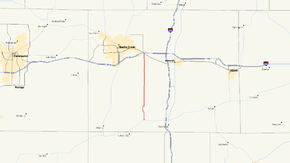
M-311 highlighted in redRoute information Maintained by MDOT Length: 13.600 mi[2] (21.887 km) Existed: October 1, 1998[1] – present Major junctions South end:  M-60 in Burlington
North end:  I-94 near Battle Creek
Location Counties: Calhoun Highway system Michigan State Trunkline Highway System
Interstate • US • State←  I-296
I-296M-331 → M-311 is a 13.600-mile (21.887 km) long state trunkline highway in Calhoun County in the US state of Michigan that runs from the intersection of M-60 in Burlington north to I-94 at Exit 104 in Emmett Township. It was previously an unsigned state trunkline, meaning that no reassurance markers were used to identify the highway. The route mainly consists of 11 Mile Road, which was a county road prior to the 1998 rationalization process.
Contents
Route description
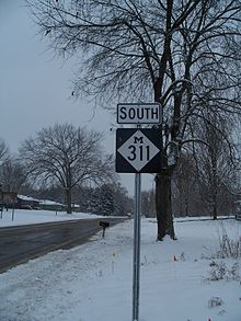 M-311 sign along the highway in December 2009
M-311 follows 11 Mile Road between M-60 and I-94. In the city of Burlington, M-311 is known as Marshall Street. There is a jog in 11 Mile Road as it runs northwesterly between Q Drive and O Drive. At N Drive, M-311/11 Mile Road turns along N Drive a short distance before turning back northward. Near D Drive, 11 Mile Road passes Hyde Lake. M-311 crosses the Kalamazoo River just south of I-94. All of M-311 is two-lane, rural highway in forest lands and farm fields,[3][4] and none of it is listed on the National Highway System.[5]
History
M-311 was created on October 1, 1998 as a part of Governor John Engler's Rationalization process. The original routing started at BL I-94/Michigan Avenue and Raymond Avenue. It followed Raymond Avenue to Emmet Street before turning east to Cooper Avenue. From Cooper Avenue, M-311 turned east again on N Drive North until meeting 11 Mile Road. There it followed 11 Mile Road south to M-60 in Burlington.[1] Since the original transfer, all of M-311 north of I-94 was returned to Calhoun County control. This eliminated the section that made a "U-turn". Since December 2009, the highway has been signed in the field.[4]
Major intersections
The entire highway is in Calhoun County.
Location Mile[2] Destinations Notes Burlington 0.000 M-60 (Leroy Street)Emmett Charter Township 13.600 I-94 – Detroit, ChicagoExit 104 on I-94 1.000 mi = 1.609 km; 1.000 km = 0.621 mi References
- ^ a b "MDOT Accepts Responsibility for 120 Miles of Local Roads" (Press release). Michigan Department of Transportation. September 24, 1998. http://www.michigan.gov/mdot/0,1607,7-151-9620_11057-94859--,00.html. Retrieved August 26, 2008.
- ^ a b "MDOT Physical Reference Finder Application". Michigan Department of Transportation. 2009. http://www.mcgi.state.mi.us/prfinder/. Retrieved August 22, 2010.
- ^ Google, Inc. Google Maps – Overview map of M-311 (Map). Cartography by Google, Inc. http://maps.google.com/maps?f=d&source=s_d&saddr=W+Leroy+St+%26+N+Marshall+St,+Burlington,+MI+49029&daddr=11+Mile+Rd%2FWheatfield+Rd&hl=en&geocode=FRZ_ggIdEcjt-ikzB3f8E90XiDFBANg0DQZE0w%3BFXxvhQId7MHt-g&mra=ls&sll=42.278833,-85.086365&sspn=0.120023,0.128231&ie=UTF8&t=h&z=12. Retrieved August 22, 2010.
- ^ a b Michigan Department of Transportation (2010). Official Department of Transportation Map (Map). 1 in.:15 mi/1 cm:9 km.
- ^ Michigan Department of Transportation (April 23, 2006) (PDF). National Highway System, Michigan (Map). http://www.michigan.gov/documents/MDOT_NHS_Statewide_150626_7.pdf. Retrieved October 7, 2008.
External links
Categories:- State highways in Michigan


Wikimedia Foundation. 2010.