- U.S. Route 16
-
U.S. Route 16
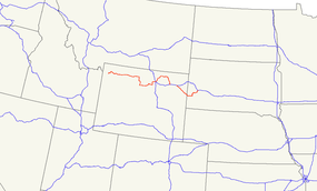
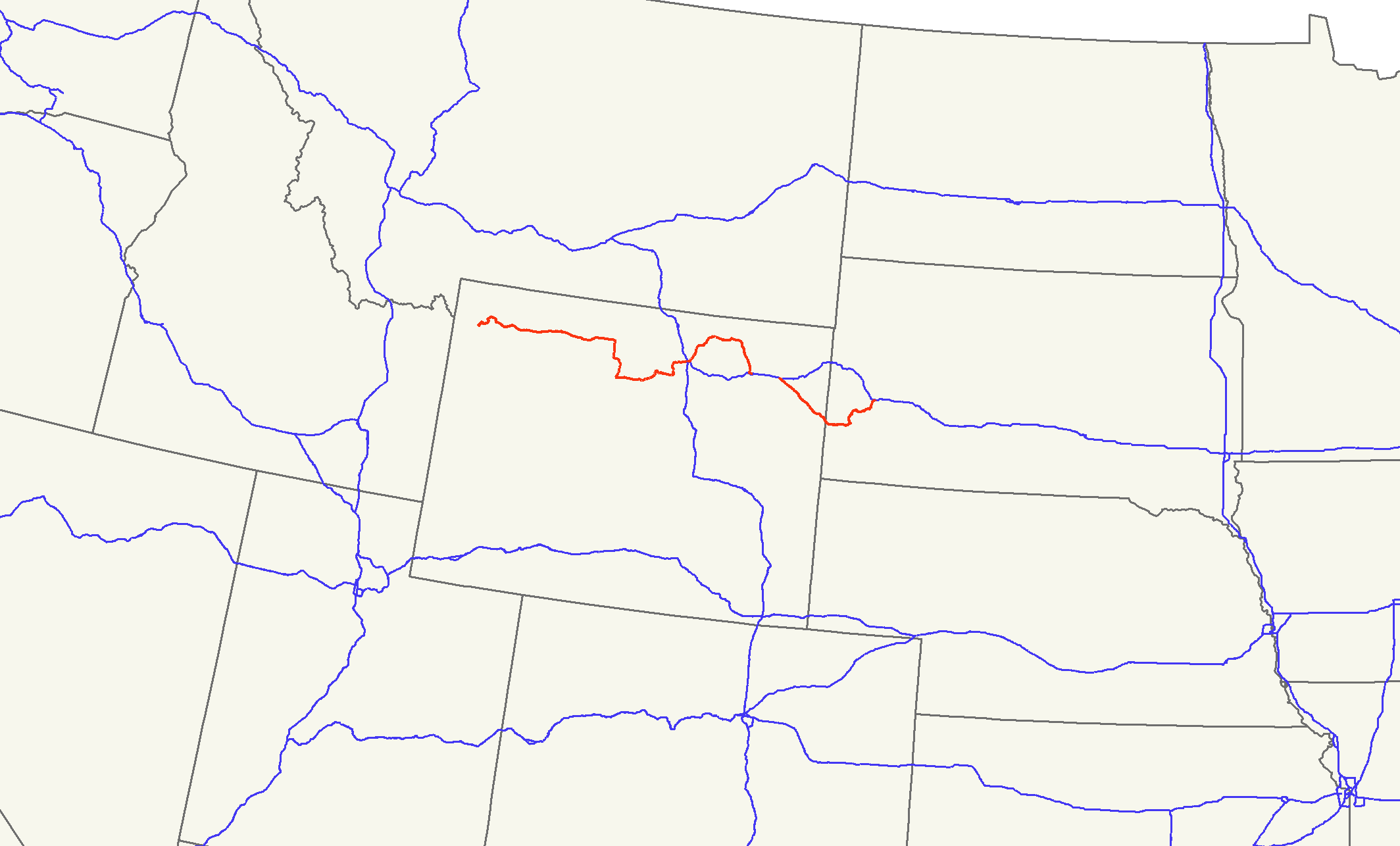
US 16 highlighted in redRoute information Length: 540 mi[1] (869 km) Existed: 1926[1] – present Major junctions West end: 
 US 14 / US 20 at Yellowstone National Park entrance
 I-25 / US 87 in Buffalo, WY
 US 85 in Newcastle, WY
East end: 
 I-90 / I-190 / US 14 in Rapid City, SD
Highway system United States Numbered Highways
List • Bannered • Divided • Replaced←  WYO 14
WY US 18  →
→←  SD 15
SD 15SD SD 17  →
→U.S. Route 16 (US 16) is an east–west United States Highway between Rapid City, South Dakota and Yellowstone National Park in Wyoming.
As of 2004, the highway's eastern terminus is at a junction with Interstate 90/U.S. Route 14 (I-90/US 14), concurrent with I-190, in Rapid City, South Dakota. The western terminus is the east entrance to Yellowstone National Park, concurrent with US 14 and US 20.
Contents
Route description
Wyoming
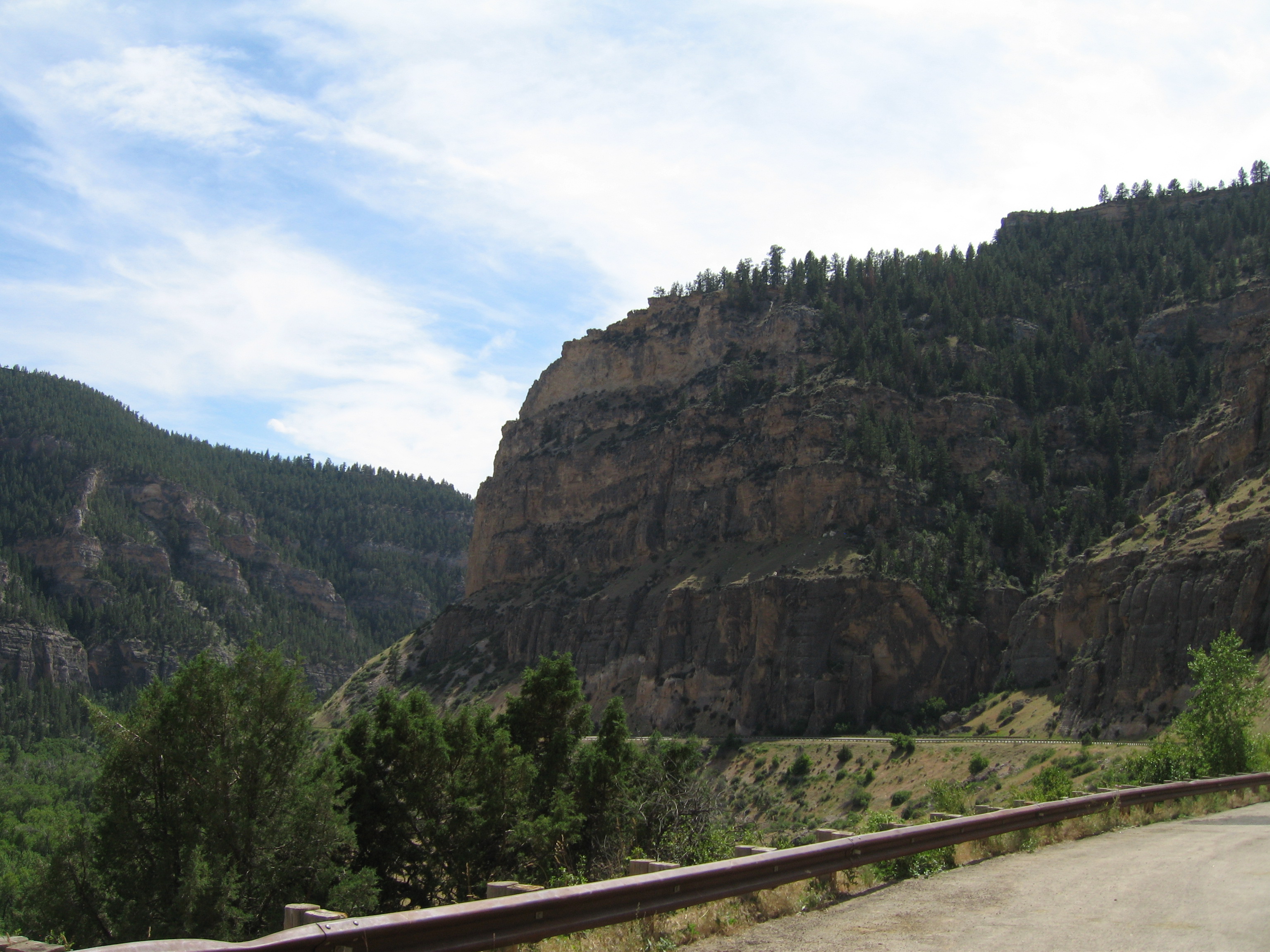
US 16 in Wyoming crosses through the towns of Newcastle and Upton before joining I-90 near Moorcraft. It runs concurrently with I-90 to Gillette, where it splits off north and then arcs back down to the town of Buffalo. From Buffalo it goes over the Powder River Pass on its way to Worland. In Worland, it turns north and overlaps US 20 through the towns of Basin and Greybull. In Greybull, the two routes combine with US 14 and go west to Cody and into Yellowstone National Park. For most of the way it is a two-lane road.
South Dakota
US 16 is also known as Mount Rushmore Road in western South Dakota. The highway enters South Dakota east of Newcastle, Wyoming. It travels near Jewel Cave, the second-longest cave in the world.[2] The highway goes through the city of Custer and shares alignment with US 385. East of Hill City, US 16 splits off US 385. It then becomes a four-lane divided highway, with the two roadways separated by up to a half-mile (0.8 km) in some places, including the old gold-mining town of Rockerville, South Dakota, which is contained entirely between the two roadways. In Rapid City, a newly complete truck bypass runs along Catron Boulevard and Elk Vale Road up to Exit 61 on I-90.
The South Dakota section of US 16 is defined at South Dakota Codified Laws § 31-4-138.[3]
History
Main article: U.S. Route 16 in Michigan US 16 in Wyoming, westbound to Ten Sleep
US 16 originally connected Detroit with Yellowstone, including a ferry link across Lake Michigan between Muskegon, Michigan, and Milwaukee, Wisconsin. In Michigan, the route was in use long before automobiles and was known to white settlers as the Grand River Road, and prior to the designation of US Routes in 1926, had been designated as M-16 in the 1920s from Detroit to south of Muskegon. In 1938, reflectorized discs were placed on US-16 every 100 feet (30 m) from Detroit to Lansing, resulting in fewer nighttime traffic accidents. Other states would later do the same on their roads.
US 16 initially crossed the South Dakota – Wyoming state line west of Spearfish. U.S. Route 216 was commissioned in 1930 as a loop off US 16 to the south between Rapid City and Moorcroft, crossing the state line west of Custer. In 1934, US 16 was moved to the US 216 alignment, while the former US 16 became part of an extension of US 14.
In Michigan, most of US 16 was superseded by I-96 and a segment of Grand River Avenue in Detroit ultimately became M-5. US 16 was later decommissioned in Wisconsin, Minnesota, and eastern South Dakota to its present termini. Between Rapid City and Dexter, Minnesota, it has been supplanted by I-90. East of there it is now Minnesota State Highway 16 and Wisconsin Highway 16. In South Dakota it was replaced by various state highways (including SD Highway 38) and county roads: generally, in West River the old alignment was transferred to county responsibility entirely, while in East River it remained a state-maintained highway.
An older Alternate US 16 in South Dakota has become South Dakota State Highway 240.
Major intersections
Mileage resets at the state line crossing
County Location Mile[4][5][6] Destinations Notes Yellowstone National Park 0.00 US 14 / US 20West end of US 14 / 20 overlap Park Cody 49.87  WYO 291
52.36 
US 14 Alt. east,  WYO 120 north
West end of WYO 120 overlap 54.58 WYO 120East end of WYO 120 overlap Big Horn 85.66  WYO 30
86.26  WYO 32
100.75 
 US 310 / WYO 789 north
North end of WYO 789 overlap Greybull 204.05 US 14East end of US 14 overlap 199.27  WYO 36 (Golf Course Road)
Basin 196.42 WYO 30185.52  WYO 433
Manderson 184.35  WYO 31
Washakie Worland 0.00 US 20 / WYO 789 west,  WYO 432 south
East end of US 20 overlap, south end of WYO 789 overlap Ten Sleep 26.42  WYO 434
30.04  WYO 436
33.90  WYO 435
Johnson Buffalo 92.12 


 I-25 Bus. / US 87 Bus. / WYO 196 (Main Street)
South end of WYO 196 overlap 100.00
I-25 Bus. / US 87 Bus. / WYO 196 (Main Street)North end of WYO 196 overlap 100.61 I-25 / US 87Interchange 2.12 I-90Interchange Sheridan Ucross 17.64 US 14West end of US 14 overlap 54.72  WYO 341
Campbell 102.07  WYO 59
North end of WYO 59 overlap Gillette 114.86  WYO 50 (Skyline Drive)
113.10 WYO 59 (Douglas Highway)South end of WYO 59 overlap 127.57 I-90,  WYO 51 ahead
West end of I-90 overlap Crook Moorcroft 153.41 I-90East end of I-90 overlap 153.56 WYO 51200.00 US 14East end of US 14 overlap Weston Upton 219.83  WYO 116
West end of WYO 116 overlap 220.13 WYO 116East end of WYO 116 overlap Osage 233.29  WYO 451
245.67  WYO 450
Newcastle 247.34
 US 16 Bus.
248.99
US 16 Bus.249.82 US 85259.08
0.00Wyoming – South Dakota state line Custer Custer 26.46 
 US 385 / SD 89
South end of US 385 overlap
West end of SD 89 overlap26.96  US 16A / SD 89
East end of SD 89 overlap Pennington 37.49  SD 87 (Needles Highway)
37.69  SD 244
Hill City 40.51 


US 16 Truck / US 385 Truck41.06
US 16 Truck / US 385 Truck45.00 US 385North end of US 385 overlap 50.60 US 16ARapid City 64.19
US 16 Truck69.00  SD 44 (Omaha Street)
East end of SD 44 overlap 69.20 I-190
SD 44 (Omaha Street) westSouth end of I-190 overlap
West end of SD 44 overlapI-190: 1.46 I-90North end of I-190 overlap 1.000 mi = 1.609 km; 1.000 km = 0.621 mi
Concurrency terminus • Closed/Former • Incomplete access • UnopenedSee also
Related routes
- U.S. Route 116
- U.S. Route 216
Bannered and suffixed routes
- U.S. Route 16 Alternate in Powell, Wyoming[citation needed]
- U.S. Route 16A in South Dakota
References
- ^ a b US Highways from US 1 to US 830 Robert V. Droz
- ^ "Jewel Cave National Monument". U.S. National Park Service. http://www.nps.gov/jeca/index.htm. Retrieved May 18, 2008.
- ^ South Dakota Codified Laws
- ^ "Reference Marker Book" (PDF). Wyoming Department of Transportation. November 2004. http://www.dot.state.wy.us/webdav/site/wydot/shared/Planning/Reference%20Marker%20Book.pdf. Retrieved April 26, 2011.
- ^ "U.S. 16 Junction List". AARoads. September 22, 2005. http://www.aaroads.com/west/us-016x_wy.html. Retrieved April 26, 2011.
- ^ "State Highway Log - Rapid City Region" (PDF). South Dakota Department of Transportation. January 2011. http://www.sddot.com/pe/data/docs/SHLRapidCityRegion.pdf. Retrieved April 13, 2010.
External links
 Main U.S. Routes
1 2 3 4 5 6 7 8 9 10 11 12 13 14 15 16 17 18 19 20 21 22 23 24 25 26 27 28 29 30 31 32 33 34 35 36 37 38 40 41 42 43 44 45 46 48 49 50 51 52 53 54 55 56 57 58 59 60 61 62 63 64 65 66 67 68 69 70 71 72 73 74 75 76 77 78 79 80 81 82 83 84 85 87 89 90 91 92 93 94 95 96 97 98 99 101 163 400 412 425 Lists U.S. Routes • Bannered • Divided • Bypassed Categories:- U.S. Highway System
- U.S. Route 16
- State highways in Michigan
- U.S. Highways in South Dakota
- U.S. Highways in Wyoming

Wikimedia Foundation. 2010.