- U.S. Route 87
Infobox U.S. Route
article_route=87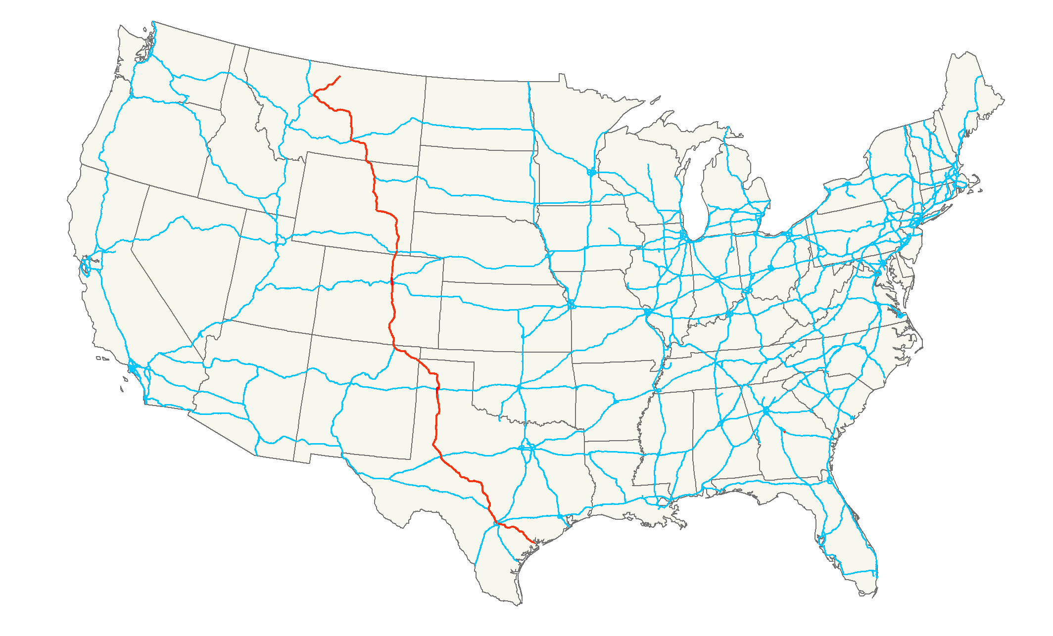
length_mi=1,998Droz, Robert V. [http://www.us-highways.com/usbt.htm U.S. Highways : From US 1 to (US 830)] . URL accessed 02:55, 4 July 2006 (UTC).]
length_km=3,215
yrcom=1926
direction_a=South
direction_b=North
from=Jct|state=TX|TX|238 in Port Lavaca, TX
junction=Jct|state=TX|I|35 at San Antonio, TX
Jct|state=TX|I|10 from San Antonio to Comfort, TX
Jct|state=TX|I|20 at Big Spring, TX
Jct|state=TX|I|27 from Lubbock to Amarillo, TX
Jct|state=TX|I|40 at Amarillo, TX
Jct|state=WY|I|25 from Raton, NM to Buffalo, WY
Jct|state=CO|I|70|I|76 at Denver, CO
Jct|state=WY|I|80 at Cheyenne, WY
Jct|state=MT|I|90 from Buffalo, WY to Billings, MT
to=Jct|state=MT|US|2 at Havre, MTU.S. Highway 87 is a north-south
United States highway (though it is signed east-west inNew Mexico ) that runs for 1,998 miles (3,215 km) from northernMontana to southernTexas . The entire portion fromBillings, Montana , toRaton, New Mexico , is co-signed along Interstates 90 and 25. It is also co-signed along the entire length ofInterstate 27 in Texas.As of
2004 , the highway's northern terminus isHavre, Montana , atU.S. Highway 2 . Its southern terminus isPort Lavaca, Texas .Route description
Texas
New Mexico
US 87 continues in a northwesterly direction in
New Mexico , merging withUS 64 (and thus the Santa Fe Trail National Scenic Byway) in Clayton, shortly after entering New Mexico. It continues to the northwest until Des Moines, when it takes a more westerly approach to Raton. In Raton, it sheds US 64 and merges withInterstate 25 , with which it remains concurrent but unsigned northward until it terminates atInterstate 90 , which it then follows west toBillings, Montana .Colorado
US 87 remains concurrent with Interstate 25 throughout the state of Colorado.
Wyoming
US 87 remains concurrent with Interstate 25 northward until the terminus with
Interstate 90 . It then follows I-90 west into Montana.Montana
US 87 remains concurrent with Interstate 90 westward until Billings, where it breaks off and heads north. Between Crow Agency and Billings, US 87 and I-90 are merged with
US 212 . It intersects with (and briefly merges with)US 12 in Roundup and continues north with a slight bend to the northwest until, at Grass Range it takes a sharp turn to the west at an intersection with Montana State Highway 200. US 87 remains concurrent with Montana State Highway 200 until Great Falls. In Lewistown, it merges withUS 191 and remains heading generally west. Some ten miles (16 km) out of Lewistown, it breaks with US 191 and merges with Montana State Highway 3, heading generally northwest and merging briefly withUS 89 before breaking with all three in Great Falls. US 87 heads northeast then east to Fort Benton and then generally northeast to its terminus withUS 2 about two miles (3 km) west of Havre.History
U.S. Route 185 was formed in 1926, and extended from US 85 in Cheyenne north to Orin. It became part of a southern extension and realignment of US 87 in 1936.
ee also
Related routes
*
U.S. Highway 187
*U.S. Highway 287 Bannered and suffixed routes
*U.S. Route 87 Business in
Cheyenne, Wyoming References
###@@@KEYEND@@@###
Wikimedia Foundation. 2010.