- U.S. Route 91
Infobox road
type=US
route=91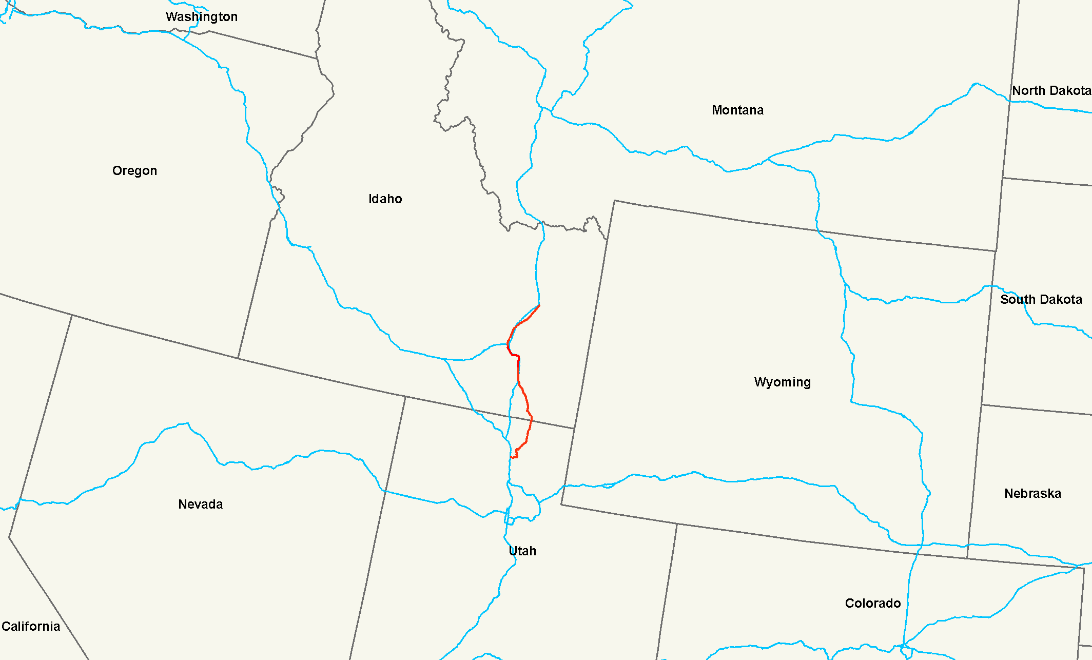
length_mi=172.663
length_ref= [Sum of Utah and Idaho milage logs in the Major intersections section of this article]
length_round=3
established=1926cite map|publisher=U.S. Department of Agriculture|title=|year=1926]
direction_a=South
direction_b=North
terminus_a=jct|state=UT|I|15|I|84 in Brigham City, UT
junction=jct|state=UT|US|89 in Logan, UT
jct|state=ID|US|30 in McCammon, ID
jct|state=ID|I|86 in Pocatello, ID
terminus_b=jct|state=ID|BL|15|dab1=Idaho Falls|US|26 in Idaho Falls, IDU.S. Route 91 is a north-south
United States highway . The highway currently serves as a connection between theCache Valley area of Utah and Idaho to the Salt Lake and Pocatello population centers. Prior the mid-1970s, U.S. 91 was a long haul route fromLong Beach, California to the Canadian border north ofSweetgrass, Montana . The route has been largely replaced byInterstate 15 . A portion of the highway's former route in California is currently State Route 91.Route description
Utah
US-91 begins at Brigham City and winds its way through the
Wellsville Mountains using Box Elder and Wellsville Canyons for its path to theCache Valley . Along the way it passes Mantua and Lake Mantua and passes over Sardine Summit. Once entering Cache Valley it serves as the major thoroughfare of the valley. Logan is the largest city in the valley. Both the Utah and Idaho portions of Cache Valley are part of the Logan Utah Metropolitan Statistical Area.The Utah section of US-91 is defined at Utah Code Annotated § 72-4-115(1).cite web |url=http://le.utah.gov/~code/TITLE72/htm/72_04_011500.htm |title=Utah Code |publisher = State of Utah |accessdate=2007-12-11]
Idaho
U.S. 91 continues serving the Idaho portion of the Cache Valley with Preston as the largest city. The highway passes by the
Bear River Massacre Site , aNational Historic Landmark , near Preston. The U.S. 91 corridor in Cache Valley Idaho was the primary filming location for the movieNapoleon Dynamite .After leaving Cache Valley, the highway then crosses back to rejoin the path of Interstate 15. At Pocatello, U.S. 91, U.S. 30 and I-15 Business Loop separate from Interstate 15 and run concurrently, passing through a small portion of the Idaho State University campus. U.S. 30 separates from U.S. 91 near the Pocatello City hall at what was once the starting point of one of Idaho's first designated highways, the Yellowstone Park Highway. From this point the highway generally follows the original route of the Yellowstone Park Highway until it reaches its terminus at its intersection with U.S. 26 south of Idaho Falls.
History
At its peak, from 1947 to 1965, U.S. 91 extended from the
Pacific Ocean atLong Beach, California toCoutts, Alberta . North ofRiverside, California , U.S. 91 mostly paralleled modern I-15. There are some parts where U.S. 91/I-15 had divergent paths. The first is fromLittlefield, Arizona toSaint George, Utah where the two routes took different paths through theArizona Strip . The second is the surviving portion of U.S. 91 from Brigham City to Downey, where Interstate 15 follows an old route ofU.S. Route 191 .cite map
publisher = H.M. Gousha Company
title =Road Atlas (hosted by Broer Map Library)
url = http://www.broermapsonline.org/members/NorthAmerica/UnitedStates/NorthernRockies/gousha_ra_1967_024.html
edition =
year = 1967
cartography=
scale =
series =
page = 42
section =
accessdate = 2008-01-27
accessmonth= 01
accessyear = 2008
isbn =
id = ]Utah first submitted a petition to
AASHTO to have the U.S. 91 designation truncated in 1971. This petition was approved onJune 21 ,1971 . However, the state did not take action until 1974. Utah officials co-ordinated a second petition with the transportation departments of California, Nevada and Arizona. In this unified petition officials in Utah proposed the number changeover take place in 1974. Nevada requested postponing the deletion of U.S. 91 as Nevada expected to complete the last piece of I-15 in 1975. Nevada officials suggestedU.S. Route 40 be similarly truncated, as this highway largely duplicatedInterstate 80 in the same states. Despite Nevada's request, the petition was submitted and approved in 1974. cite web
url=http://www.dot.utah.gov/main/uconowner.gf?n=200609181116091
title = Highway Resolution route 91
publisher =Utah Department of Transportation
accessdate=2008-03-08]Retracing the path of historic U.S. Route 91 is possible but difficult. In most cities the route of U.S. 91 is still in use as a local street or highway. In many rural areas, I-15 was literally built on top of the former U.S. 91.
The highway passed through the following states:
*California (until 1974)
*Nevada (until 1974)
*Arizona (10 miles (16 km) in theArizona Strip , until 1974)
*Utah
*Idaho
*Montana (until 1980)California
U.S. 91's original southern terminus was at the intersection of Atlantic Avenue (historically SR 15) and East Pacific Coast Highway (SR 1) in Long Beach. This intersection also marked the historic western terminus of US 6, which proceeded west from that intersection. East of the intersection, U.S. 91 proceeded east along East Pacific Coast Highway to Los Alamitos Circle.
The portions in California were replaced with:
*State Route 1 (Pacific Coast Highway from Atlantic Avenue to the Traffic Circle)
*State Route 19 (Lakewood Boulevard from the Traffic Circle to Lincoln Avenue)
*State Route 214 (route no longer a state highway - Carson Street and Lincoln Avenue)
*State Route 91
*Interstate 215
*Interstate 15Nevada
The route of U.S. 91 in Nevada was replaced with I-15.
In Las Vegas, U.S. 91 was better known as Las Vegas Boulevard (State Route 604). The intersection of Las Vegas Boulevard and Fremont Street is the historic intersection with U.S. 93 and U.S. 95. Here, U.S. 466 left U.S. 91 and headed south on Fremont Street with U.S. 93 and 95. At this intersection, U.S. 93 and 95 left Fremont Street and turned north onto Las Vegas Boulevard, heading north with U.S. 91. One block further up, at Bonanza Road, U.S. 95 turned west until it hit Rancho Drive, then continued north. U.S. 91/93 stayed aligned with Las Vegas Boulevard.
Leaving Las Vegas, U.S. 91 followed I-15 to exit 112 (NV 170) to Mesquite (NV 144) and then to Hillside Drive into
Arizona , where the road became Fairview Avenue.Arizona
U.S. 91 entered Arizona from Nevada on Fairview Avenue and followed it northeast to Littlefield. Once Fairview Avenue crosses I-15, it became Cane Beds Road through downtown Beaver Dam and into
Utah , where the road continued as Old Highway 91.Utah
From the State Line to Saint George US-91 followed a semi-circular route that is now simply called Old Highway 91. Old Highway 91 continues to Santa Clara and what is now SR-18 to St. George. cite map
publisher = Benchmark Maps
title = Utah Road and Recreation Atlas
url = http://www.benchmarkmaps.com
edition = 2002
year = 2002
cartography=
scale = 1:250000
series =
page = 80
section = G3
accessdate =
accessmonth=
accessyear =
isbn = 0-929591-74-7
id = ]From St. George to Springville US-91 is in the shadows of I-15. At places the old pavement is visible off to the side of the freeway; at others I-15 was paved over the old US-91.
US-91 first joined U.S. Route 89 in Springville at one of the oldest grade-separated interchanges in Utah (this portion is now State Route 51). From this junction to Logan the two highways ran mostly concurrent. This portion is mostly intact as US-89.
US-91 did have a unique route between Farmington and Ogden and where US-89/91 split and then rejoined on what is now State Route 126 and State Route 26. These highways form the Main Street through Kaysville and Layton; State Street from the Layton-Clearfield border to Main Street in Clearfield though the city of Sunset turning into 1900 West at the Sunset-Roy border, then following 1900 W to a junction with Riverdale Road in Roy, then following Riverdale Road through Riverdale, and then meeting back up with US-89 at Washington Blvd in Ogden.
Idaho
U.S. 91 formerly entered Idaho Falls along Yellowstone Highway, and returned to the course of modern I-15 north of town. The highway then proceeded north toward
Monida Pass where the highway enteredMontana . In some small towns streets used by the route are called "Old Highway 91".cite web
url = http://maps.google.com/maps?f=q&hl=en&geocode=&q=Idaho+Falls,+Idaho&ie=UTF8&ll=44.149942,-112.213669&spn=0.09287,0.114155&z=13
title = Google Maps, northern Idaho
publisher=Google Maps
accessdate=2008-03-09]Montana
In Montana the highway's alignment slightly changed with the construction of the
Clark Canyon State Recreation Area . In Dillon the former route of the highway is now known as Atlantic Street and Montana Street.cite web
url = http://maps.google.com/maps?f=q&hl=en&geocode=&q=Idaho+Falls,+Idaho&ie=UTF8&ll=45.249513,-112.646084&spn=0.091123,0.114155&z=13
title = Google Maps, Dillon Montana
publisher=Google Maps
accessdate=2008-03-09] . North of Dillon I-15 was built on a new alignment. The highway formerly joined withU.S. Route 10 in Butte and formed the main street of Boulder. The highway was routed through Helena along what is nowMontana Secondary Highway 518 andMontana Secondary Highway 229 .Major intersections
ee also
*
California State Route 91
*Interstate 15 References
###@@@KEYEND@@@###
Wikimedia Foundation. 2010.