- California State Route 19
Infobox road
state=CA
type=SR
route=19
section=319 and 464
maint=Caltrans
alternate_name=Lakewood Boulevard, Rosemead Boulevard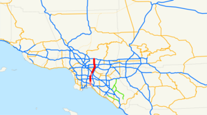
length_mi=26.2
length_ref= [California Department of Transportation , [http://web.archive.org/web/20040306063946/http://www.dot.ca.gov/hq/traffops/trucks/trucksize/truckmap/ State Truck Route List] , updatedApril 1 ,2004 ]
length_round=1
length_notes=(prior to relinquishments)
established=1934 [ [http://www.cahighways.org/017-024.html#019 California Highways: State Route 19] ]
direction_a=South
terminus_a=jct|state=CA|SR|1 in Long Beach
junction=jct|state=CA|SR|91 near Lakewood
jct|state=CA|I|5 in Downey
jct|state=CA|I|10 near El Monte
direction_b=North
terminus_b=jct|state=CA|I|210 in Pasadena
previous_type=SR
previous_route=18
next_type=SR
next_route=20
browse=ca browse
previous_type=SR
previous_route=163
route=
next_type=SR
next_route=165State Route 19 (SR 19), locally known as Lakewood Boulevard and Rosemead Boulevard, [ [http://www.westcoastroads.com/california/ca-019.html California @ WestCoastRoads.com - State Route 19] ] is a
state highway in theLos Angeles area of theU.S. state ofCalifornia . The route is a north-south four-to-six lanesuburb an roadway, lying between theLong Beach Freeway (I-710) andSan Gabriel River Freeway (I-605), and connecting the eastern parts of Long Beach and Pasadena via theWhittier Narrows . Since 1998, several pieces have been relinquished to local governments, and more transfers are authorized by state law. The portion of SR 19 north of the Whittier Narrows is officially State Route 164, once planned to be upgraded as the Rio Hondo Freeway [ [http://www.cahighways.org/161-168.html#164 California Highways: Unsigned State Route 164] ] , but has always been signed as part of SR 19.Route description
tate Route 19
Lakewood Boulevard (no longer SR 19 in Long Beach) begins at the
Long Beach Traffic Circle (postmile 0.00),dubious where State Route 1 (Pacific Coast Highway) heads west and southeast, and Los Coyotes Diagonal heads northeast. It heads north past Interstate 405 (San Diego Freeway ) (PM 1.05), passing under a runway of theLong Beach Airport . (The part through the airport has been relocated to the east; parts of the old alignment remain as airport service roads.)As the Long Beach portion of SR 19 has been relinquished, SR 19 now legally begins at the intersection of Lakewood Boulevard and Del Amo Boulevard, at the southern city limits of Lakewood [http://nl.newsbank.com/nl-search/we/Archives?p_product=LB&p_theme=lb&p_action=search&p_maxdocs=200&p_topdoc=1&p_text_direct-0=0EAE92EBDEA59978&p_field_direct-0=document_id&p_perpage=10&p_sort=YMD_date:D&s_trackval=GooglePM" State begins transfer of Lakewood Boulevard] ] . SR 19 passes to the west of Lakewood Center Mall before passing through the neighborhood of Mayfair dubious and entering the city of Bellflower. Whereas SR 19 in Bellflower can legally be relinquished by the state to the city, this process has not taken place. SR 19 intersects State Route 91 before straddling the city border between Bellflower and Paramount and later Bellflower and Downey. North of Gardendale Street, SR 19 has been relinquished to the city of Downey.
In Downey, Lakewood Boulevard intersects with Interstate 105 before passing by the Rockwell International Space Division and interchanging with Interstate 5. At this latter interchange, Lakewood Boulevard turns into Rosemead Boulevard [http://www.downeygis.org/downeyca/minutes/MINSCC090903.pdf Minutes Of The City Council ] ] . Once Rosemead Boulevaard crosses Telegraph Road, it enters Pico Rivera, where SR 19 has been relinquished to the city as well [http://news.google.com/archivesearch?q=%22Caltrans+relinquished+the+piece+of+Rosemead+Boulevard%22+rivera&btnG=Search+Archives&num=100&hl=en&um=1&ie=UTF-8 "Caltrans relinquished the piece of Rosemead Boulevard in Pico Rivera - Google News Archive Search ] ] . Rosemead Boulevard then continues through Pico Rivera past Pico Rivera Plaza to Gallatin Road.Cite map | publisher=Thomas Brothers | title=Los Angeles and Orange Counties Street Guide and Directory | year=1999 | page=566, 596, 636, 676, 706, 736, 766, 796]
tate Route 164
The 9.56-mile (15.39 km) piece of SR 19 north of Gallatin Road in Pico Rivera has been State Route 164 since the 1964 renumbering, but has always been signed as SR 19. Original plans for SR 164 took it southeast to Interstate 605 from the present transition between SR 164 and SR 19. SR 164 begins as Rosemead Boulevard leaves the city of Pico Rivera and enters an
unincorporated area .SR 164 travels across
Whittier Narrows Dam before entering theWhittier Narrows Recreation Area and intersecting with thecloverleaf interchange of State Route 60. After this, SR 164 enters South El Monte before crossing theRio Hondo and straddling the city boundary between Rosemead and El Monte. SR 164 then intersects with Interstate 10 before passing by Rosemead Shopping Center. The next section of SR 164 was relinquished to Temple City in 2008 [http://info.sen.ca.gov/pub/07-08/bill/sen/sb_0901-0950/sb_910_bill_20070223_introduced.pdf SB910] ] .Upon leaving Temple City, the maintenance of SR 164 transfers to the county, for this segment of SR 164 has been relinquished [http://lacounty.info/omd/q3_2006/cms1_048914.pdf CPY Document ] ] . Rosemead Boulevard continues north to Interstate 210. Presently, the north end of the route is at I-210 about a mile south of Sierra Madre Villa Avenue. Originally planned as a
freeway , it was to be the intermediate north-south freeway between I-710 (theLong Beach Freeway ) and I-605 (theSan Gabriel River Freeway ). Today, locals generally refer to this road as either Lakewood Boulevard or Rosemead Boulevard, not by its numerical designation.Bus service is provided by
Metro Local 266, which is operated by theLos Angeles County Metropolitan Transportation Authority .History
Before the present SR 19 was constructed, San Gabriel Boulevard, which extended from Lamanda Park south to Downey, and was widened and repaved by an
assessment tax in 1925, [Los Angeles Times , Celebrate Paving of Boulevard,November 4 ,1925 ] was the main road through theWhittier Narrows , requiring several turns to stay on it and to continue south to ) near Lamanda Park. [cite CAstat|year=1933|ch=767|p=2040: "State Highway Route 60 near Long Beach to State Highway Route 9 near Lamanda Park."] [cite CAstat|year=1935|ch=29|p=286: "Route 168 is from Route 60 near Long Beach to Route 9 near Lamanda Park."]SR 19 was designated out of the 1964 state highway renumbering. However, since then, many segments of SR 19 have been relinquished to the cities that they run through.
Caltrans relinquished Long Beach's portion of SR 19 to the city in 1998, and Downey's segment of SR 19 was relinquished to the city in 2001. However, the segment in Pico Rivera was not relinquished to that city until 2004. In October 2006, the northern portion of SR 164 that went through an unincorporated area of the county from Callita Street to Foothill Boulevard was relinquished to the county. In 2008, the section of SR 164 through Temple City was relinquished to that city.Major intersections
:"Note: Except where prefixed with a letter,
postmile s were measured in 1964, based on the alignment as it existed at that time, and do not necessarily reflect current mileage."The entire route is in Los Angeles County.References

Wikimedia Foundation. 2010.