- California State Route 58
-
State Route 58
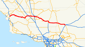
Route information Defined by S&HC § 358 Maintained by Caltrans Length: 241 mi[1] (388 km) Existed: 1964 – present Major junctions West end:  US 101 near Santa Margarita
 I-5 near Buttonwillow
 SR 99 in Bakersfield
 SR 14 near Mojave
 US 395 near Kramer Jct
East end:  I-15 in Barstow
Highway system State highways in California(list • pre-1964)
History • Unconstructed • Deleted • Freeway • Scenic←  SR 57
SR 57SR 59  →
→Contents
State Route 58 (SR 58) is an east-west highway across the California Coast Ranges, the southern San Joaquin Valley, the Tehachapi Mountains, which border the southern Sierra Nevada, and the Mojave Desert. It runs between its western terminus near Santa Margarita (junction U.S. Route 101) and its eastern terminus at Barstow (junction Interstate 15). It has junctions with Interstate 5 near Buttonwillow, State Route 99 in Bakersfield, State Route 202 in Tehachapi, State Route 14 in Mojave, and U.S. Route 395 at Kramer Junction. Route 58 gives good access to Edwards Air Force Base.
Route description
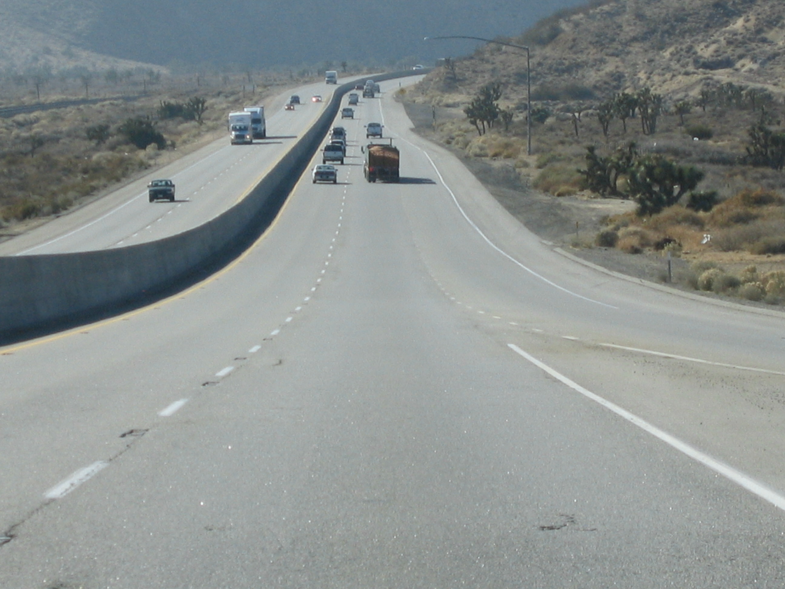
 Westbound SR 58 near Mojave
This route is part of the California Freeway and Expressway System[2] and is eligible for the State Scenic Highway System.[3] However, it is not a scenic highway as designated by Caltrans.[4]
Route 58 has several names throughout its length, including the Blue Star Memorial Highway (for its entire length); the Kern County Korean War Veterans Memorial Highway, for the section from Route 184 to the Kern County/San Bernardino County Line; and the Rosa Parks Highway, for the section between Route 99 and Route 184. The Korean War Veterans name honors the approximately 8,120 veterans from Kern County, while the section named for Rosa Parks honors the civil rights activist.[5] The portion of the 58 from Barstow to Bakersfield is sometimes referred to as the Barstow–Bakersfield Highway.[6]
Route 58 is a freeway from its south junction with Route 99 in Bakersfield to several miles east of Mojave (a freeway bypass of Mojave was completed in 2004), except for two grade-level intersections two miles (3 km) apart in the Caliente area. There is another grade level intersection east of Mojave and west of the main Edwards AFB north gate exit where California City Blvd. intersects it. Other freeway segments are bypasses of Boron and Barstow. Except for the Boron freeway bypass, SR 58 is primarily a four lane expressway (two lanes per direction) just east of Boron up to the Barstow bypass segment with the exception of the portion of Route 58 between Boron and approximately 5 miles (8.0 km) east of Kramer Junction, which is currently two-lane highway and is not yet expressway.
Route 58 takes the southernmost route through the Sierra Nevada and allows motorists to travel between Northern California and points to the east, such as Las Vegas and Interstate 40 without having to face the extreme traffic congestion of greater Los Angeles. Route 58 and Interstate 80 are the only freeways to cross the Sierra Nevada. The route also offers an alternative to the often treacherous Donner Pass to truckers traveling from the San Francisco Bay Area to points eastward; prior to the construction of Interstate 80, the road (as U.S. Route 466) was heavily used for this purpose.
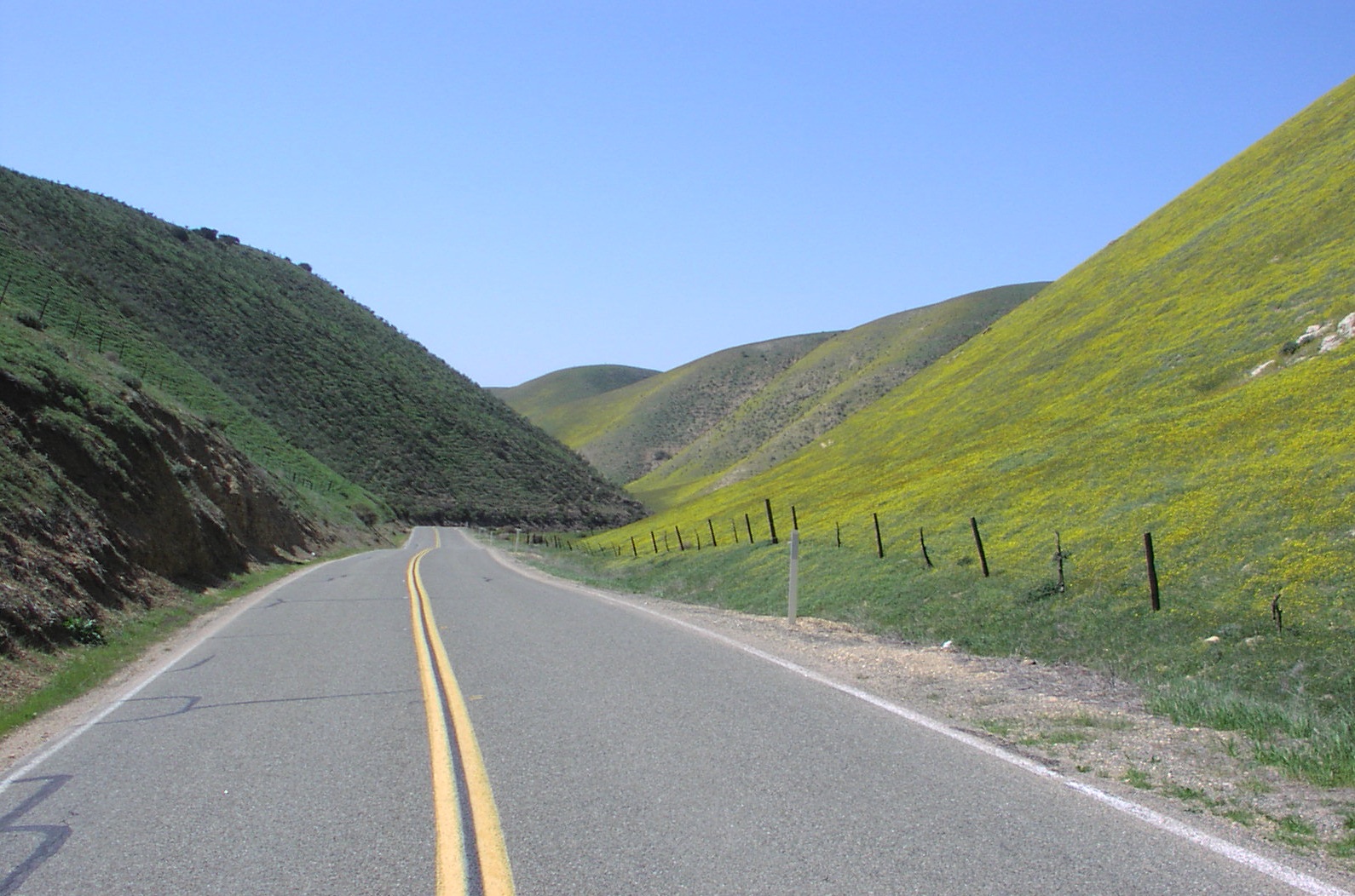
Route 58 west of Buttonwillow is a winding mountain road through a thinly-populated area. Alternatives such as State Route 46 to the north or State Route 166 to the south are recommended, such as on signage approaching the western terminus of Route 58 from US 101, for those not wishing to traverse so mountainous a route; much of this section of Route 58 is prohibited to truck traffic. However, this section of SR 58 does pass through the Carrizo Plain, which is known for its scenic beauty and geological features, including the San Andreas Fault.
History

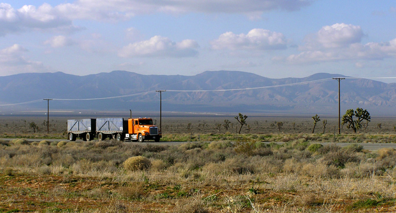
 A truck passes eastbound along the busy Highway 58 through the Antelope Valley. The Tehachapi Mountains are visible in the distance.
Route 58 did not exist as a California sign route until 1964 although previous to 1964 it was part of California legislative route 58. The other part of legislative route 58 is California's segment of Interstate 40; previous to 1964 it was a segment of US 66.
Prior to 1964 the segment of SR 58 between Bakersfield and Barstow was signed U.S. Route 466. Also at that time, the segment of Route 58 between State Route 33 at Mc Kittrick and Route 99 in Bakersfield was signed as State Route 178. Although it was proposed for signing as Route 178 in 1934, the segment of legislative route 58 between US 101 near Santa Margarita and State Route 33 at Mc Kittrick was not signed prior to 1964.
Note that US 466 was co-signed with US 99, now State Route 99, between Bakersfield and Famoso Junction. Between Famoso and US 101 at Paso Robles, US 466 largely became SR 46.
The eastern terminus was originally at I-15 north of Barstow. Route 58 was rerouted to I-15 in Barstow south of the I-40 interchange. The former eastern terminus is now known as "Old Highway 58."
Future
California has long sought federal funds for an extension of Interstate 40 west of Barstow; any such extension would use the general path of Route 58, if not existing highway, as far west at least as Bakersfield, whose rapid growth has made it a significant generator of traffic in its own right. The desired highway is being built piecemeal as Caltrans has funds available, at least between Mojave and Barstow. A Bakersfield Beltway is also proposed. Two at-grade intersections within 1½ miles of each other around mile 76, roughly halfway between Bakersfield and Mojave, would have to be either closed or upgraded to interchanges for the whole of Route 58 to be up to Interstate standards, and the at-grade junction of Route 58 and US 395 in Kramer Junction is further complicated by the nearby Union Pacific Railroad Tehachapi line (a busy single track over which BNSF also operates) which Route 58 also crosses at grade two and a half miles to the west.
The San Luis Obispo Planning Commission is considering a permit application for the California Valley Solar Ranch and has released a Draft Environmental Impact Report with a public comment period closure date Nov 1, 2010. Among the points raised in the DEIR is the aesthetic impact on the viewshed which would be particularly troublesome if large industrial scale arrays of solar panels are placed north of Route 58 in the section of road just east of Soda Lake Road.
Business loops
Mojave
40px
State Route 58 Business
Location: Mojave, California State Route 58 Business is a Business route of California State Route 58 in Mojave. It provides access to downtown Mojave as Mojave-Barstow Highway. It also follows the former routing of U.S. Route 6 and U.S. Route 466.
Tehachapi
40px
State Route 58 BusinessLocation: Tehachapi, California State Route 58 Business is a Business route of California State Route 58 in Tehachapi. It provides access to downtown Tehachapi as Tehachapi Boulevard. It also follows the former routing of U.S. Route 466 and is overlapped with State Route 202.
Boron
40px
State Route 58 BusinessLocation: Boron, California State Route 58 Business is a Business route of California State Route 58 in Boron. It provides access to downtown Boron as Twenty Mule Team Road. It also follows the former routing of U.S. Route 466. It is signed from westbound Route 58 approaching the San Bernardino-Kern county line and the beginning of the Boron bypass.
Major intersections
- Note: Except where prefixed with a letter, postmiles were measured in 1964, based on the alignment as it existed at that time, and do not necessarily reflect current mileage. The numbers reset at county lines; the start and end postmiles in each county are given in the county column.
County Location Postmile
[7][8][9]Exit
[10][11]Destinations Notes San Luis Obispo
SLO 0.00-57.15Santa Margarita 0.00 US 101Interchange El Camino Real 3.14 Pozo Road – Santa Margarita Lake 6.89  SR 229 north – Creston, Shandon
La Panza Road – Paso Robles  Bitterwater Road to SR 46 – Cholame
45.20 Soda Lake Road – California Valley, Soda Lake Serves Carrizo Plain National Monument Kern
KER 0.00-R143.86McKittrick 15.41
33.45[N 1] SR 33 south – Taft
West end of SR 33 overlap 34.29[N 1]
15.42 SR 33 north – CoalingaEast end of SR 33 overlap Buttonwillow 27.28 Buttonwillow Drive to I-5 northMirasol Avenue – Taft 28.75 Wasco Way – Tupman 31.64 I-5 – Sacramento, Los AngelesInterchange 39.96
8.11[N 2] SR 43 north (Enos Lane) – Shafter
West end of SR 43 overlap 9.16[N 2]
39.97 SR 43 south (Enos Lane) / Sidding Road – TaftEast end of SR 43 overlap Bakersfield 46.10 Allen Road – Shafter 48.11 Calloway Drive Coffee Road 51.81
25.65[N 3] SR 99 north / SR 178 east (24th Street) – Fresno, Sacramento, Downtown Bakersfield
Interchange; west end of SR 99 overlap West end of freeway on SR 99 24.60[N 3] 25 California Avenue – Civic Center 23.62[N 3] Stockdale Highway, Brundage Lane Eastbound exit and westbound entrance 23.51[N 3]
R52.36110A SR 99 south – Los AngelesEast end of SR 99 overlap; no exit number eastbound T52.14 Real Road Westbound left exit and eastbound entrance R53.39-
R53.52111 Chester Avenue, H Street R54.42 112  SR 204 (Union Avenue, SR 99 Bus.)
Former US 99 R55.40 113 Cottonwood Road R56.41 114 Mt. Vernon Avenue R57.41 115 Oswell Street R58.44 116 Fairfax Road R59.44 117  SR 184 (Weedpatch Highway, Morning Drive) – Lamont
R61.51 119 Edison Road – Edison R63.58 121 Comanche Drive – Arvin, Edison R65.68 123 Tower Line Road 69.75 127 General Beale Road East end of freeway 75.63  SR 223 west – Arvin
77.25 Bealville Road – Caliente West end of freeway 80.24 137 Hart Flat 82.06 139 Keene R85.15 142 Broome Road R90.72 148  SR 202 (Tehachapi Boulevard, SR 58 Bus. east) – Tehachapi
Tehachapi R91.67 149 Mill Street R94.16 151 Tehachapi Boulevard (SR 58 Bus. west) – Monolith, Tehachapi R99.49 156 Sand Canyon Road – Monolith R101.56 159 Cameron Road R108.90 165 
 SR 58 Bus. east – Mojave
Former US 466 east / SR 58 east R111.13 167 SR 14 – Bishop, MojaveFormer US 6 R116.22 172
SR 58 Bus. west – MojaveFormer US 466 west / SR 58 west East end of freeway R127.63 California City Boulevard – California City West end of freeway R129.67 186 Edwards AFB R132.04 188 Clay Mine Road R136.40 193 Twenty Mule Team Road Former US 466 east R137.77 194 Gephart Road, Rocket Site Road R139.80 196 Borax Road (SR 58 Bus. east), Rocket Site Road Boron R142.87 199 Boron Avenue – Boron San Bernardino
SBD R0.00-R34.81East end of freeway Twenty Mule Team Road (SR 58 Bus. west) Former US 466 west Kramer Junction 5.40 US 395 – Bishop, San BernardinoR30.39 Lenwood Road Former US 466 east / SR 58 east West end of freeway Barstow R33.65 West Main Street (to I-15 Bus.) – Barstow Former US 66 / US 91 R34.81  I-15 (Mojave Freeway) to I-40 – Las Vegas, San Bernardino
Eastbound exit and westbound entrance 1.000 mi = 1.609 km; 1.000 km = 0.621 mi
Concurrency terminus • Closed/Former • Incomplete access • UnopenedReferences
- ^ January 1, 2006 California Log of Bridges on State Highways
- ^ CA Codes (shc:250-257)
- ^ CA Codes (shc:260-284)
- ^ "Officially Designated State Scenic Highways and Historic Parkways". California Department of Transportation. December 7, 2007. http://www.dot.ca.gov/hq/LandArch/scenic_highways/. Retrieved June 22, 2011.
- ^ 2007 Named Freeways, Highways, Structures and Other Appurtenances in California. Caltrans. pp. 131–132. http://www.dot.ca.gov/hq/tsip/hseb/products/Named_Freeways.pdf. Retrieved 2007-03-28.
- ^ Pitchford, Phil (2006-01-07). "Proposal hints at traffic relief". The Press-Enterprise. http://www.pe.com/localnews/inland/stories/PE_News_Local_D_ieroads07.22b2ef1b.html. Retrieved 2009-02-15.
- ^ California Department of Transportation, State Truck Route List (XLS file), accessed February 2008
- ^ California Department of Transportation, Log of Bridges on State Highways, July 2007
- ^ California Department of Transportation, All Traffic Volumes on CSHS, 2005 and 2006
- ^ California Department of Transportation, California Numbered Exit Uniform System, State Route 58 Freeway Interchanges, Retrieved on 2009-02-05.
- ^ California Department of Transportation, California Numbered Exit Uniform System, State Route 99 Freeway Interchanges, Retrieved on 2009-02-05.
External links
Categories:- State highways in California
- Southern California freeways
- Scenic highways in California
- Roads in San Luis Obispo County, California
- Roads in Kern County, California
- Roads in San Bernardino County, California
- Mojave Desert


Wikimedia Foundation. 2010.