- California State Route 43
Infobox road
state=CA
type=SR
route=43
section=343
maint=Caltrans 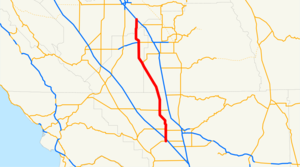
length_mi=98
length_round=0
length_ref= [ [http://www.dot.ca.gov/hq/structur/strmaint/brlog2.htm January 1, 2006 California Log of Bridges on State Highways] ]
direction_a=South
terminus_a=jct|state=CA|SR|119 near Taft
junction=jct|state=CA|SR|46 in Wasco
jct|state=CA|SR|198 near Hanford
direction_b=North
terminus_b=jct|state=CA|SR|99 in Selma
previous_type=SR
previous_route=41
next_type=SR
next_route=44State Route 43 is a north-south
state highway in theU.S. State ofCalifornia , routed along the southernSan Joaquin Valley connecting the towns of Shafter, Wasco, Hanford, and Selma, running roughly parallel to SR 99. The route begins southwest of Bakersfield at an intersection with SR 119 and it quickly crosses I-5 and heads north until reaching SR 58, and then it angles northwest until reaching Wasco. North of Wasco, the road is called the "Central Valley Highway" and it remains two lanes wide for its entire length until its northern terminus in Selma with SR 99.Caltrans has plans to widen SR 43 between the Kings County/Fresno County line and SR 99, but due to the California budget crisis, plans have been put on hold.This route is part of the
California Freeway and Expressway System [http://www.leginfo.ca.gov/cgi-bin/displaycode?section=shc&group=00001-01000&file=250-257 CA Codes (shc:250-257)] ] .Major intersections
:"Note: Except where prefixed with a letter,
postmile s were measured in 1964, based on the alignment as it existed at that time, and do not necessarily reflect current mileage. The numbers reset at county lines; the start and end postmiles in each county are given in the county column."External links
* [http://www.dot.ca.gov/hq/roadinfo/sr43 Caltrans: Route 43 highway conditions]
* [http://www.cahighways.org/041-048.html#043 California Highways: SR 43]References

Wikimedia Foundation. 2010.