- California State Route 73
-
State Route 73
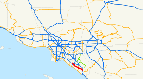
Route information Defined by S&HC § 373 Maintained by Caltrans and TCA Length: 17.764 mi[1] (28.588 km) Existed: 1996 – present Major junctions South end:  I-5 in Mission Viejo
North end:  I-405 in Costa Mesa
Highway system State highways in California(list • pre-1964)
History • Unconstructed • Deleted • Freeway • Scenic←  SR 72
SR 72SR 74  →
→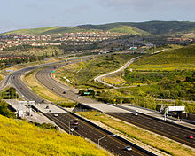 California State Route 73 climbs into the San Joaquin Hills, as seen looking southward from University Hills in Irvine. In the foreground is the Bonita Canyon Drive exit.
State Route 73 (SR 73) is a state highway in the U.S. state of California. The route runs from Interstate 405 to Interstate 5 through the San Joaquin Hills in Orange County. From its northern terminus, the first three miles (5 km) of the highway are called the Corona del Mar Freeway; this section of highway opened in 1978. The next 12 miles (19 km) of the 15-mile (24 km) highway, made in November 1996, are a toll road operated by the San Joaquin Hills Transportation Corridor Agency named the San Joaquin Hills Transportation Corridor. State Route 73 runs approximately parallel to the Pacific Coast Highway and the San Diego Freeway. Its north terminus is Interstate 405 in Costa Mesa near Fairview Avenue. It then proceeds through the San Joaquin Hills and reaches its southern terminus of Interstate 5 in San Juan Capistrano. There are no HOV lanes currently, but the medians have reserved spots for them if the need arises in the future for their construction.
Contents
Route description
State Route 73 is part of the California Freeway and Expressway System.[2] SR 73 begins in San Juan Capistrano at an interchange with I-5. The freeway heads northwest into the city of Laguna Niguel before the tolled portion begins at the Greenfield Drive exit. SR 73 continues into the city of Aliso Viejo before entering Laguna Beach, where SR 73 intersects SR 133 with a separated-grade exit. Following this, the road passes through Crystal Cove State Park, where the main toll plazas are located. After leaving the state park, SR 73 straddles the border between Irvine and Newport Beach and provides easy access to University of California, Irvine through the Bison Avenue exit. Following the MacArthur Boulevard exit, the tolled part of the road ends. SR 73 continues into Newport Beach, running along the southern boundary of Orange County John Wayne Airport (IATA Airport Code SNA). Entering Costa Mesa, SR 73 interchanges with SR 55 before merging with I-405 and terminating the route.[3]
History
Most of State Route 73 is a limited-access toll highway designed to reduce congestion within Orange County on the Pacific Coast Highway (State Route 1) and the San Diego Freeway (Interstates 5, and 405) by providing a direct route through the San Joaquin Hills.
State Route 73 is not a toll road over its entire length. From its northbound terminus heading southbound, the first three miles (5 km) of State Route 73 have no tolls and make up the entire Corona Del Mar Freeway. State Route 73's previous alignment had the freeway portion end at MacArthur Boulevard, and the SR 73 designation ran along MacArthur south to meet Route 1 in Corona del Mar. Under the current alignment, heading southbound, State Route 73 becomes a designated toll road immediately after the Jamboree/MacArthur ramp and remains so until its southern terminus at I-5. Though the next ramp heading southbound (Bison Avenue) is part of the toll road, it is toll-free, as is the first ramp heading northbound from the southern terminus (Greenfield Drive).
Design and construction of the highway cost a total of $800 million. The design and construction was overseen by the San Joaquin Hills Transportation Corridor Agencies, or SJHTCA, an agency formed in 1986 for the express purpose of designing the tollway. In the end, State Route 73 included 10 interchanges, 68 bridges, 725 000 square feet (67,000 m²) of retaining walls, and 32 million cubic yards (24,000,000 m³) of excavation at completion. Construction was divided into four different sections, each with its own management system and quality control. A joint venture led by Kiewit Pacific Co., a subsidiary of Kiewit Corporation, completed this project.
State Route 73's toll road was the first to be financed with tax-exempt bonds on a stand-alone basis including construction and environmental risk.
Tolls
The tolls on SR 73 begin only after the Bison Ave. exit in the southbound direction. In the northbound direction, there is a toll in effect after Greenfield Drive, the first ramp north of the highway's terminus. Travelers who drive the entire length of the 73 will only encounter one toll booth, the Catalina View Toll Plaza. Patrons who use an exit along the toll road are charged a prorated toll.
Since its inception, the San Joaquin Hills toll road has used the FasTrak electronic toll collection system, allowing drivers to travel the entire distance without stopping or even slowing down as their tolls are collected electronically by overhead radios reading the transponder mounted on the vehicle. Travelers using FasTrak pay a discounted toll. FasTrak patrons may also drive through cash-designated lanes at any toll plaza without stopping. The radio receivers overhead detect the vehicle before it even approaches the cash deposit area and automatically turns the traffic light green.
The following table lists the tolls at each of the tolled exits, both with and without FasTrak:
- As of July 1, 2011[4]
Toll Booth Pay Cash FasTrak Bonita Canyon Dr Southbound Exit $1.25 $0.80 Newport Coast Dr Southbound Exit $2.25 $1.85 CATALINA VIEW TOLL PLAZA
Price assumes 2-axle automobile.Peak: $5.75 Off-Peak: $5.00
Weekends: $4.75Peak: $5.00 Off-Peak: $4.20
Weekends: $3.95El Toro/Laguna Canyon Rd Northbound Exit $2.50 $2.10 Aliso Creek Rd Northbound Exit $2.00 $1.60 La Paz Road/Moulton Pkwy Northbound Exit $1.75 $1.30 Exit list
- Note: Except where prefixed with a letter, postmiles were measured in 1964, based on the alignment as it existed at that time, and do not necessarily reflect current mileage.
The entire route is in Orange County.
Location Postmile
[1][5][6]Exit
[7]Destinations Notes Mission Viejo 10.00 I-5 south (San Diego Freeway) – San DiegoSouthbound exit and northbound entrance Laguna Niguel 11.76 2 Greenfield Drive Aliso Viejo 12.91 3 Moulton Parkway Southbound exit and northbound entrance 13.40 3 La Paz Road 14.39 4 Aliso Creek Road 15.25 5 Pacific Park Drive, Glenwood Drive Southbound exit and northbound entrance 16.25 6 El Toro Road (CR S18) Signed as exit 7 southbound 16.75 7  SR 133 (Laguna Canyon Road)
Signed as exit 6 northbound 18.70 Catalina View toll plaza Irvine 21.43 11 Newport Coast Drive 22.45 12 Bonita Canyon Drive North end of toll road 23.46 13 Bison Avenue Newport Beach 23.82 14A MacArthur Boulevard – Newport Beach Southbound exit and northbound entrance; former SR 73 south 23.82 14 MacArthur Boulevard – John Wayne Airport Northbound exit and southbound entrance 24.36 14B University Drive Southbound exit and northbound entrance R24.78 15 Jamboree Road No northbound exit R25.45 15 Birch Street Northbound exit and southbound entrance R25.58 16 Campus Drive, Irvine Avenue Southbound exit and northbound entrance Costa Mesa R26.58 17A  SR 55 north (Costa Mesa Freeway)
Northbound exit and southbound entrance R26.58 17B SR 55 south (Costa Mesa Freeway)Signed as exit 17A southbound R27.28 17C Bear Street Signed as exit 17B southbound 18B Fairview Road Northbound exit and southbound entrance 18A Harbor Boulevard Northbound exit only R27.81 I-405 north (San Diego Freeway) – Long BeachNorthbound exit and southbound entrance 1.000 mi = 1.609 km; 1.000 km = 0.621 mi
Concurrency terminus • Closed/Former • Incomplete access • UnopenedReferences
- ^ a b California Department of Transportation, State Truck Route List (XLS file), accessed February 2008
- ^ CA Codes (shc:250-257)
- ^ Thomas Brothers (2008). Orange County Street Atlas (Map).
- ^ "The Toll Roads Rate Card". https://www.thetollroads.com/assets/objects/other/TR_RateCard.pdf. Retrieved 9/5/2011.
- ^ California Department of Transportation, Log of Bridges on State Highways, July 2007
- ^ California Department of Transportation, All Traffic Volumes on CSHS, 2005 and 2006
- ^ California Department of Transportation, California Numbered Exit Uniform System, State Route 73 Freeway Interchanges, Retrieved on 2009-02-07.
External links
Freeways in Greater Los Angeles Radial Hollywood (US 101/SR 170) • Golden State (I-5) • Antelope Valley (SR 14) • Glendale (SR 2) • Pasadena/Arroyo Seco Pkwy (SR 110) • San Bernardino (I-10) • Pomona (SR 60) • Santa Ana (I-5/US 101) • Laguna (SR 133) • Corona del Mar (SR 73) • Long Beach (I-710) • Seaside (SR 47) • Terminal Island (SR 103) • Harbor (I-110/SR 110) • Marina (SR 90) • Santa Monica (I-10)Circumferential Inland Empire Chino Valley (SR 71) • Foothill (SR 210) • Moreno Valley (SR 60) • Riverside (SR 91) • San Bernardino (I-10/I-215) • I-10 • I-15 • I-215 • SR 259 • SR 330Toll Toll roads and bridges in California SF Bay Area bridges North–south directionEast–west directionRichmond – San Rafael Bridge · San Francisco – Oakland Bay Bridge · San Mateo – Hayward Bridge · Dumbarton BridgeSoCal toll roads Eastern (SR 133/SR 241/SR 261) · Foothill (SR 241) · San Joaquin Hills (SR 73) · South Bay Expressway (SR 125)HOT lanes Tolling system Agencies Categories:- Toll roads in California
- State highways in California
- Roads in Orange County, California
- Southern California freeways
- Costa Mesa, California


Wikimedia Foundation. 2010.