- Mission Viejo, California
-
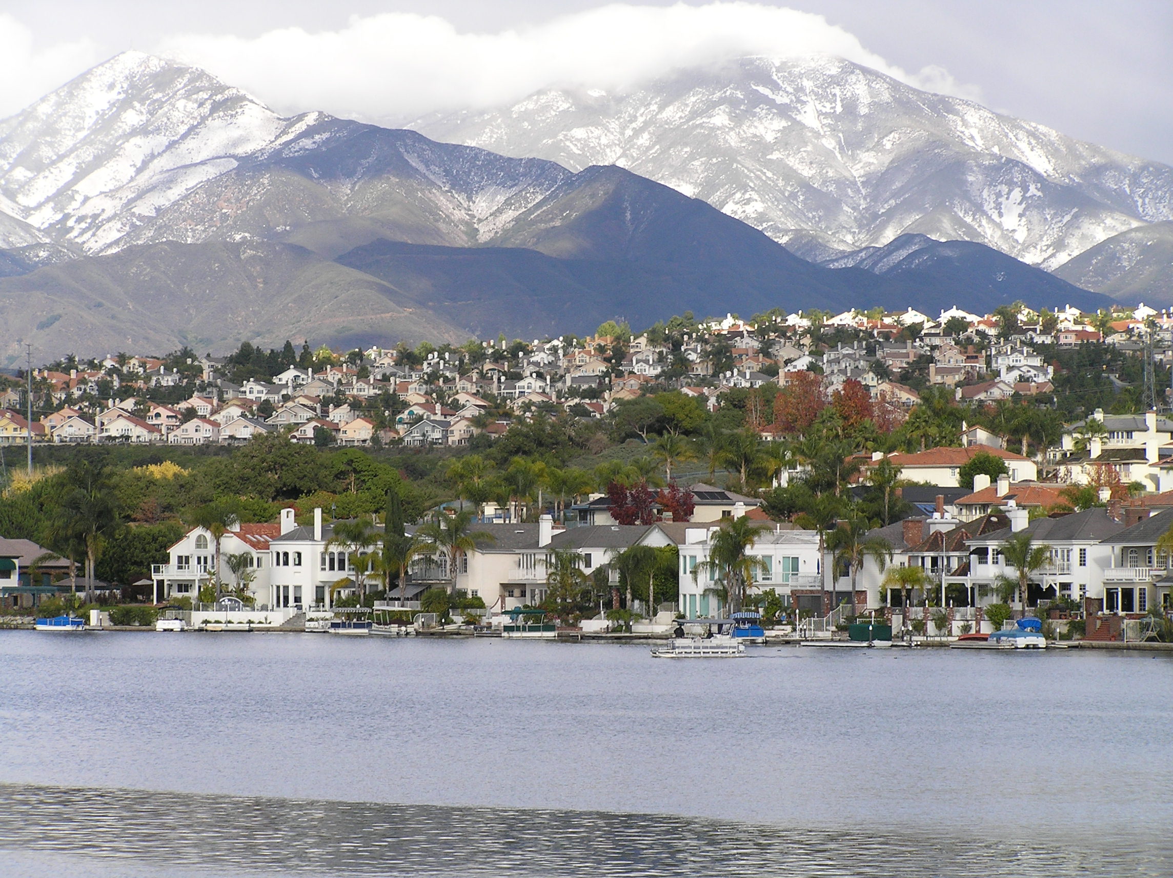
City of Mission Viejo — City — The Saddleback Mountains and Lake Mission Viejo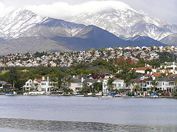
SealLocation of Mission Viejo within Orange County, California.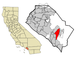
Coordinates: 33°36′46″N 117°39′22″W / 33.61278°N 117.65611°WCoordinates: 33°36′46″N 117°39′22″W / 33.61278°N 117.65611°W Country  United States
State  California
County Orange Government – Mayor Dave Leckness Area[1] – Total 18.123 sq mi (46.939 km2) – Land 17.739 sq mi (45.944 km2) – Water 0.384 sq mi (0.995 km2) 2.12% Elevation 397–500 ft (121 m) Population (2011) – Total 93,483 – Density 5,158.2/sq mi (1,991.6/km2) Time zone PST (UTC-8) – Summer (DST) PDT (UTC-7) Zip Code 92690, 92691, 92692, 92694 Area code(s) 949 FIPS code 06-48256 GNIS feature ID 1661045 Website www.cityofmissionviejo.org Mission Viejo (
 /ˈmɪʃən viːˈeɪhoʊ/) is a city located in southern Orange County, California in the Saddleback Valley. Mission Viejo is considered one of the largest master-planned communities ever built under a single project in the United States, and is rivaled only by Highlands Ranch, Colorado, in its size. The city has a 2011 estimated population of 93,483,[2]
Mission Viejo is suburban in nature and culture. The city is mainly residential, although there are a number of offices and businesses within its city limits. The city is known for its picturesque tree-lined neighborhoods, receiving recognition from the National Arbor Day Foundation. The city's name is a reference to Rancho Mission Viejo, a large Spanish land grant from which the community was founded.
Mission Viejo was named the safest city in the United States in a 2007 Morgan Quitno crime statistic survey (compiled from FBI data). In 2009, it was named the safest city in California and third safest in the nation, according to CQ Press.
Contents
History
Mission Viejo was a hilly region primarily used as cattle and sheep grazing land, since it was of little use to farmers. This city was one of the last regions of Orange County to be urbanized due to its geologic complexity. Mission Viejo was purchased by John Forster, a Mexican also known as Don Juan. During the Mexican-American War, Foster provided fresh horses to United States military forces which were used on the march of San Diego to retake Los Angeles.
In 1960, early developers dismissed most of the land in Mission Viejo as simply "undevelopable".[3] Donald Bren, an urban planner who later became the president of the Irvine Company, drafted a master plan which placed roads in the valleys and houses on the hills, and contoured to the geography of the area. The plan worked, and by 1980 much of the city of Mission Viejo was completed. During the late 1970s and the 1980s, houses in Mission Viejo were in such high demand that housing tracts often sold out before construction even began on them. The houses and shopping centers in the city are almost uniformly designed in a Spanish mission style, with "adobe"-like stucco walls and barrel-tile roofs. Many point to Mission Viejo as the first and largest manifestation of Bren's obsession with Spanish architecture. Bren's company was also the creator of the developments in Irvine, and Newport Beach suburbs. The company expanded its operations and went on to build the Lakes project in Tempe Arizona, Mission Viejo Aurora in Colorado and was the initial master planner of Highlands Ranch, both suburbs of the Denver Metropolitan area.
The seal of the city of Mission Viejo was designed and drawn by Carl Glassford, an artist and former resident of the city.
Geography
Mission Viejo is located at 33°36′46″N 117°39′22″W / 33.61278°N 117.65611°W (33.612739, −117.656038).[4]
According to the United States Census Bureau, the city has a total area of 18.1 square miles (47 km2). 17.7 square miles (46 km2) of it is land and 0.4 square miles (1.0 km2) of it (2.12%) is water. A significant portion of the surface water is held in Lake Mission Viejo, an artificial lake stretching approximately one mile from Olympiad Road to Alicia Parkway along Marguerite Parkway.
It is bordered by Lake Forest on the northwest, Trabuco Canyon on the northeast, Rancho Santa Margarita and Ladera Ranch on the east, San Juan Capistrano on the south, and Laguna Niguel and Laguna Hills on the west.
Climate
Mission Viejo experiences a borderline semi-arid/Mediterranean climate (Köppen climate classification BSh/Csa).
Climate data for Mission Viejo Month Jan Feb Mar Apr May Jun Jul Aug Sep Oct Nov Dec Year Source: [5] Demographics
Historical populations Census Pop. %± 1970 11,933 — 1980 50,666 324.6% 1990 72,820 43.7% 2000 93,102 27.9% 2010 93,305 0.2% source:[6][7] 2010
The 2010 United States Census[8] reported that Mission Viejo had a population of 93,305. The population density was 5,148.3 people per square mile (1,987.8/km²). The racial makeup of Mission Viejo was 74,493 (79.8%) White, 1,210 (1.3%) African American, 379 (0.4%) Native American, 8,462 (9.1%) Asian, 153 (0.2%) Pacific Islander, 4,332 (4.6%) from other races, and 4,276 (4.6%) from two or more races. Hispanic or Latino of any race were 15,877 persons (17.0%).
The Census reported that 92,363 people (99.0% of the population) lived in households, 859 (0.9%) lived in non-institutionalized group quarters, and 83 (0.1%) were institutionalized.
There were 33,208 households, out of which 11,767 (35.4%) had children under the age of 18 living in them, 20,792 (62.6%) were opposite-sex married couples living together, 2,967 (8.9%) had a female householder with no husband present, 1,306 (3.9%) had a male householder with no wife present. There were 1,211 (3.6%) unmarried opposite-sex partnerships, and 225 (0.7%) same-sex married couples or partnerships. 6,314 households (19.0%) were made up of individuals and 2,949 (8.9%) had someone living alone who was 65 years of age or older. The average household size was 2.78. There were 25,065 families (75.5% of all households); the average family size was 3.18.
The population was spread out with 21,270 people (22.8%) under the age of 18, 7,852 people (8.4%) aged 18 to 24, 21,648 people (23.2%) aged 25 to 44, 29,003 people (31.1%) aged 45 to 64, and 13,532 people (14.5%) who were 65 years of age or older. The median age was 42.2 years. For every 100 females there were 95.4 males. For every 100 females age 18 and over, there were 92.2 males.
There were 34,228 housing units at an average density of 1,888.6 per square mile (729.2/km²), of which 25,859 (77.9%) were owner-occupied, and 7,349 (22.1%) were occupied by renters. The homeowner vacancy rate was 0.9%; the rental vacancy rate was 4.9%. 72,390 people (77.6% of the population) lived in owner-occupied housing units and 19,973 people (21.4%) lived in rental housing units.
2000
At the 2000 census,[9] there were 93,102 people, 32,449 households and 25,212 families residing in the city. The population density was 4,990.1 inhabitants per square mile (1,926.4/km²). There were 32,986 housing units at an average density of 1,767.9 per square mile (682.5/km²). The racial makeup of the city was 79.7% white, 1.6% African American, 0.4% Native American, 8.3% Asian, 0.1% Pacific Islander, 6.2% from other races, and 3.7% from two or more races. Hispanic or Latino of any race were 15.9% of the population. There were 32,449 households out of which 39.7% had children under the age of 18 living with them, 66.1% were married couples living together, 8.1% had a female householder with no husband present, and 22.3% were non-families. 17.3% of all households were made up of individuals and 6.0% had someone living alone who was 65 years of age or older. The average household size was 2.84 and the average family size was 3.22.
Age distribution was 27.1% under the age of 18, 6.6% from 18 to 24, 30.5% from 25 to 44, 24.9% from 45 to 64, and 10.9% who were 65 years of age or older. The median age was 38 years. For every 100 females there were 95.7 males. For every 100 females age 18 and over, there were 91.7 males.
According to a 2008 estimate, the median household income was $93,330, and the median family income was $113,439.[10] Males had a median income of $74,703 versus $53,196 for females. The per capita income for the city was $41,459. 1.9% of families and 4.4% of the population were below the poverty line, including 5.1% of those under age 18 and 6% of those age 65 or over.
Recreation and services
Mission Hospital is the largest hospital in south Orange County and serves as the area's regional trauma center. It also offers one of two Children's Hospital of Orange County locations providing care for children.
Mission Viejo has numerous recreational areas such as the Norman P. Murry Community and Senior Center[11] there are about two parks per square mile. The city has three golf courses, The Mission Viejo Country Club, Casta del Sol Golf Course, and the Arroyo Trabuco Golf Club. At the center of the city is a man-made lake, Lake Mission Viejo, a private association for Mission Viejo residents with custom waterfront homes, condominiums, boat rentals, and swim beaches.
Economy
According to the City's 2010 Comprehensive Annual Financial Report,[12] the top employers in the city were:
# Employer # of employees 1 Saddleback College 2,196 2 Mission Hospital 1,349 3 Unisys 1,000 4 Quest Diagnostics 500 5 Coldwell Banker 410 6 Saddleback Valley Unified School District 400 Politics
Of the 56,286 registered voters in the city, 31,090 (55.2%) are Republicans, 14,319 (25.4%) are Democrats, 8,790 (15.6%) declined to state political affiliation, and the remaining 2,087 (3.8%) are registered with a minor party.
In the state legislature Mission Viejo is located in the 33rd Senate District, represented by Republican Mimi Walters, and in the 71st Assembly District, represented by Republican Jeff Miller. Federally, Mission Viejo is located in California's 42nd congressional district, which has a Cook PVI of R +10[13] and is represented by Republican Gary Miller.
Sports
Mission Viejo has a major youth athletic facility, Mission Viejo Youth Athletic Park. The park consists of eight baseball fields and five soccer fields. It is host to Little League District 68 [2], AYSO Region 84 [3] and four competitive soccer clubs: Pateadores Soccer Club, Mission Viejo Soccer Club, West Coast Futbol Club, and Saddleback United Soccer Club.
The Mission Viejo Nadadores Swimming and Mission Viejo Nadadores Diving Team won a string of national championships and produced a number of Olympians and world record holders in the 1970s and 1980s. Olympians included Shirley Babashoff, Brian Goodell, Larson Jenson, Maryanne Graham, Nicole Kramer, Casy Converse, Marcia Morey, Dara Torres, and Greg Louganis.
Mission Viejo hosted the Road Cycling Events during the 1984 Summer Olympics held in Los Angeles. The old O'Neill Road was renamed Olympiad Rd. in honor of the Olympic events in 1984.
There is also a soccer facility, now used by the town's youth soccer program, that was used as a training field by the United States men's national soccer team before and during the 1994 FIFA World Cup, hosted by the United States. Mission Viejo is the largest AYSO Region in the country.
The Saddleback College ballpark hosted the Mission Viejo Vigilantes minor league baseball team of the Western Baseball League from 1996–2001. Now the ballpark has a semi-pro collegiate team, the Orange County Fire.
Mission Viejo is also the hometown of New York Jets quarterback Mark Sánchez, New York Yankees pitcher Phil Hughes, and Arizona Diamondbacks first baseman Adam LaRoche, former Milwaukee Brewers pitcher Don August and Saint Louis Cardinals outfielder Allen Craig.
Education
Mission Viejo is served by two school districts, the Capistrano Unified School District and Saddleback Valley Unified School Districts. Capistrano Unified serves the eastern, northeastern, and southern portions of the city with eight schools. As of 2006, all high school students in the Capistrano Unified portion of Mission Viejo attend Capistrano Valley High School. Students from western Mission Viejo (north of Oso Parkway and west of Marguerite until Alicia Parkway) attend Saddleback Valley's Mission Viejo High School. Far northern Mission Viejo attends Saddleback Valley's Trabuco Hills High School, though most of that school has students from Rancho Santa Margarita and Lake Forest. A few residents attend Tesoro High School in Las Flores or the private Santa Margarita Catholic High School in Rancho Santa Margarita.
Silverado High School, Mira Monte High School, and Pathfinder are continuation and adult schools within the city. Silverado High School provides a day school environment while Mira Monte, which shares the same campus, is strictly independent study.
Saddleback College, near The Shops at Mission Viejo and Capistrano Valley High School, is a large community college in the southern half of the city. In addition, the University of California, Irvine, Chapman University, Soka University of America, and California State University, Fullerton (El Toro Campus), are nearby in adjacent cities.
La Tierra Elementary shut down in June 2009 due to budget cuts. It was chosen due to its small size and minimal student body. The school will remain closed until further notice. Mission Viejo residents refer to La Tierra as "The Little School With a Big Heart." Students there are reassigned to Del Cerro Elementary.[14]
O'Neill Elementary, the city's first elementary school, closed in June 2009 also due to budget cuts in SVUSD. Students in the Deane Home community surrounding the school will be moved to nearby De Portola Elementary. Students living in the homes north of the lake will be moved to Melinda Heights Elementary in Rancho Santa Margarita.[15]
Elementary
Capistrano Unified
Saddleback Valley Unified
Private
- Carden Academy
- Al Ridah Academy – an Islamic Elementary School
Middle school
- Newhart Middle School-CUSD
- La Paz Intermediate School-SVUSD
- Los Alisos Intermediate School- SVUSD
High school
- Capistrano Valley High School-CUSD
- Halstrom High School (formerly Futures High School)-CUSD
- Mission Viejo High School-SVUSD
- Trabuco Hills High School-SVUSD
College
Notable residents
- Jordan Harvey, soccer player
- Phil Hughes, Pitcher, Major League Baseball, New York Yankees
- Mark Sanchez, Quarterback, National Football League, New York Jets
- Kaitlin Sandeno, swimmer
- Larry Sherry (1935–2006), Major League Baseball relief player
- Kina Grannis, singer and songwriter
- Jason Miller (fighter), American mixed martial artist
- Brian Goodell, Gold Medal and World Record holding swimmer
- Noah Munck, Actor, iCarly[16]
References
- ^ U.S. Census
- ^ California Department of Finance. "[1]." California Department of Finance. May 2011. Retrieved on May 7, 2011.
- ^ Vanishing Orange County - Google Books. http://books.google.com/books?id=_U7xVtLFR1gC&pg=PA33&dq=Mission+Viejo,+California+undevelopable#v=onepage&q&f=false. Retrieved March 8, 2011.
- ^ "US Gazetteer files: 2010, 2000, and 1990". United States Census Bureau. 2011-02-12. http://www.census.gov/geo/www/gazetteer/gazette.html. Retrieved 2011-04-23.
- ^ "Mission Viejo historic weather averages". Intellicast. http://www.intellicast.com/local/history.aspx?location=USCA0712. Retrieved February 18, 2010.
- ^ "CENSUS OF POPULATION AND HOUSING (1790–2000)". U.S. Census Bureau. http://www.census.gov/prod/www/abs/decennial/index.html. Retrieved July 17, 2010.
- ^ 1970 & 1980 census figures were enumerated prior to incorporation.
- ^ All data are derived from the United States Census Bureau reports from the 2010 United States Census, and are accessible on-line here. The data on unmarried partnerships and same-sex married couples are from the Census report DEC_10_SF1_PCT15. All other housing and population data are from Census report DEC_10_DP_DPDP1. Both reports are viewable online or downloadable in a zip file containing a comma-delimited data file. The area data, from which densities are calculated, are available on-line here. Percentage totals may not add to 100% due to rounding. The Census Bureau defines families as a household containing one or more people related to the householder by birth, opposite-sex marriage, or adoption. People living in group quarters are tabulated by the Census Bureau as neither owners nor renters. For further details, see the text files accompanying the data files containing the Census reports mentioned above.
- ^ "American FactFinder". United States Census Bureau. http://factfinder.census.gov. Retrieved 2008-01-31.
- ^ American FactFinder, United States Census Bureau. "Mission Viejo city, California – Income in the Past 12 Months (In 2008 Inflation-Adjusted Dollars)". Factfinder.census.gov. http://factfinder.census.gov/servlet/STTable?_bm=y&-context=st&-qr_name=ACS_2008_1YR_G00_S1901&-ds_name=ACS_2008_1YR_G00_&-CONTEXT=st&-tree_id=307&-redoLog=false&-geo_id=16000US0648256&-format=&-_lang=en. Retrieved March 6, 2011.
- ^ "Norman P Murray Community Center". City of Mission Viejo. March 4, 2011. http://cityofmissionviejo.org/DepartmentPage.aspx?id=1572. Retrieved March 8, 2011.
- ^ "City of Mission Viejo CAFR". Cityofmissionviejo.org. http://cityofmissionviejo.org/ViewDocument.aspx?id=12548. Retrieved March 14, 2011.
- ^ "Will Gerrymandered Districts Stem the Wave of Voter Unrest?". Campaign Legal Center Blog. http://www.clcblog.org/blog_item-85.html. Retrieved February 10, 2008.
- ^ http://www.ocregister.com/articles/school-tierra-children-2276846-year-close
- ^ http://www.ocregister.com/articles/mission-viejo-oneill-2332580-saddleback-school
- ^ http://www.ocregister.com/news/year-124347-ocprint-awards-world.html
External links
- City of Mission Viejo · Official website.
- Mission Viejo Public Library · Official website.
- Lake Mission Viejo Association· Official website.
- The Shops at Mission Viejo
Schools
College
Municipalities and communities of Orange County, California Cities Aliso Viejo | Anaheim | Brea | Buena Park | Costa Mesa | Cypress | Dana Point | Fountain Valley | Fullerton | Garden Grove | Huntington Beach | Irvine | La Habra | La Palma | Laguna Beach | Laguna Hills | Laguna Niguel | Laguna Woods | Lake Forest | Los Alamitos | Mission Viejo | Newport Beach | Orange | Placentia | Rancho Santa Margarita | San Clemente | San Juan Capistrano | Santa Ana | Seal Beach | Stanton | Tustin | Villa Park | Westminster | Yorba Linda
CDPs Unincorporated
communitiesAnaheim Island | Modjeska Canyon | Orange Park Acres | Santa Ana Heights | Santiago Canyon | Silverado | Trabuco Canyon
Venues of the 1984 Summer Olympics Los Angeles Albert Gersten Pavilion · Eagle's Nest Arena · Los Angeles Memorial Coliseum · Los Angeles Memorial Sports Arena · Olympic Swim Stadium · Pauley Pavilion · Streets of Los AngelesSouthern California Anaheim Convention Center · Artesia Freeway · Coto de Caza · El Dorado Park · Fairbanks Ranch Country Club · Heritage Park Aquatic Center · Lake Casitas · Long Beach Arena · Long Beach Convention Center · Long Beach Shoreline Marina · Olympic Velodrome · Prado Regional Park · Raleigh Runnels Memorial Pool · Rose Bowl · Santa Anita Park · Santa Monica College · Streets of Mission Viejo · Streets of Santa Monica · The Forum · Titan Gymnasium · Weingart StadiumOther venues Harvard Stadium (Boston, Massachusetts) · Navy – Marine Corps Memorial Stadium (Annapolis, Maryland) · Stanford Stadium (Palo Alto, California)List of Olympic venues in cycling 1896: Marathon (city), Neo Phaliron Velodrome • 1900: Vélodrome de Vincennes • 1904: Francis Field • 1908: White City Stadium • 1912: Liljeholmen, Mälaren • 1920: Antwerp, Vélodrome d'Anvers Zuremborg • 1924: Stade de Colombes, Vélodrome de Vincennes • 1928: Amsterdam, Olympic Stadium • 1932: Los Angeles Avenue, Pacific Coast Highway, Rose Bowl in Pasadena, Vineyard Avenue • 1936: Avus Motor Road, BSV 92 Field & Stadium • 1948: Herne Hill Velodrome, Windsor Great Park • 1952: Käpylä, Maunula, Pakila, Velodrome • 1956: Broadmeadows, Velodrome • 1960: Olympic Velodrome, Via Cassia, Via Flaminia, Via Cristoforo Colombo, Via di Grottarossa • 1964: Hachioji City, Hachioji Velodrome • 1968: Agustín Melgar Olympic Velodrome, Satellite Circuit • 1972: Bundesautobahn 96, Grünwald, Radstadion • 1976: Mount Royal Park, Olympic Velodrome, Quebec Autoroute 40 • 1980: Krylatskoye Sports Complex Cycling Circuit, Krylatskoye Sports Complex Velodrome, Moscow-Minsk Highway • 1984: Artesia Freeway, Olympic Velodrome, Streets of Mission Viejo • 1988: Olympic Velodrome, Tongillo Road Course • 1992: A-17 highway, Circuit de Catalunya, Sant Sadurní Cycling Circuit, Velòdrom d'Horta • 1996: Cycling road course, Georgia International Horse Park, Stone Mountain Park Archery Center and Velodrome • 2000: Centennial Parklands, Dunc Gray Velodrome, Fairfield City Farm • 2004: Athens Olympic Velodrome, Kotzia Square, Parnitha Olympic Mountain Bike Venue, Vouliagmeni Olympic Centre • 2008: Laoshan Bicycle Moto Cross (BMX) Venue, Laoshan Mountain Bike Course, Laoshan Velodrome, Urban Road Cycling Course • 2012: BMX Circuit, Hadleigh Farm, London Velodrome, Hampton Court Palace • 2016: Barra Velodrome, Flamengo Park, Olympic BMX Center, Olympic Mountain Bike Park Categories:
- Cities in Orange County, California
- Planned cities in the United States
- Incorporated cities and towns in California
- 1984 Summer Olympic venues
- Olympic cycling venues


Wikimedia Foundation. 2010.