- Norwalk, California
-
City of Norwalk — City — 
SealLocation of Norwalk in Los Angeles County, California
Coordinates: 33°54′25″N 118°05′00″W / 33.90694°N 118.0833333°WCoordinates: 33°54′25″N 118°05′00″W / 33.90694°N 118.0833333°W Country United States State California County Los Angeles Incorporated August 26, 1957 Government - Type Charter City,
Council-Manager- City Council Mike Mendez (mayor)
Cheri Kelley (vice-mayor)
Marcel Rodarte
Leonard Shryock
Luigi Vernola- City Manager Michael J. Egan - Finance Director/ Treasurer
Jana Stuard- City Clerk Theresa Devoy Area[1] - Total 9.746 sq mi (25.243 km2) - Land 9.707 sq mi (25.141 km2) - Water 0.039 sq mi (0.102 km2) 0.40% Elevation 92 ft (28 m) Population (2010) - Total 105,549 - Rank 14th in Los Angeles County
58th in California
255th in the United States- Density 10,830/sq mi (4,181.3/km2) 2010 United States Census Time zone PST (UTC-8) - Summer (DST) PDT (UTC-7) ZIP code 90650-90652, 90659 Area code(s) 562 FIPS code 06-52526 GNIS feature ID 1661123 Website ci.norwalk.ca.us Norwalk is a suburban city in Los Angeles County, California, United States. The population was 105,549 at the 2010 census, up from 103,298 at the 2000 census, making it the 58th most populous city in California and the 255th nationally.
Founded in the late 19th century, Norwalk was incorporated in as a city in 1957. It is located 17 miles (27 km) southeast of downtown Los Angeles, and 12 miles (19 km) northwest of Garden Grove.
Norwalk operates under a Council/Manager form of government, established by the Charter of the City of Norwalk which was drafted in 1957. The five-member City Council acts as the City's chief policy-making body. Every two years, Councilmembers are elected by the citizens of Norwalk to serve four-year, overlapping terms. Councilmembers are not limited to the number of terms they may serve. The Mayor is selected by the Council and serves a one-year term.
Norwalk is a member of the Gateway Cities Council of Governments. Norwalk's sister cities are Morelia, Michoacán, and Hermosillo, Sonora, in Mexico.[1]
Contents
Geography
Norwalk is located at 33°54′25″N 118°5′0″W / 33.90694°N 118.083333°W (33.906914, -118.083398).[2]
According to the United States Census Bureau, the city has a total area of 25.243 km2 (10 sq mi). 9.707 square miles (25.14 km2) of it is land and 0.039 square miles (0.10 km2) of it (0.40%) is water.
Norwalk is bordered by Downey on the Northwest, Bellflower on the Southwest, Cerritos and Artesia on the South, and Santa Fe Springs on the North and East.
Demographics
Historical populations Census Pop. %± 1960 88,739 — 1970 90,164 1.6% 1980 84,901 −5.8% 1990 94,279 11.0% 2000 103,298 9.6% 2010 105,549 2.2% source:[3] 
2010
The 2010 United States Census[4] reported that Norwalk had a population of 105,549. The population density was 10,829.6 people per square mile (4,181.3/km²). The racial makeup of Norwalk was 52,089 (49.4%) White, 4,593 (4.4%) African American, 1,213 (1.1%) Native American, 12,700 (12.0%) Asian (5.3% Filipino, 2.5% Korean, 0.9% Chinese, 0.8% Indian, 0.8% Vietnamese, 0.6% Cambodian, 0.3% Thai, 0.3% Japanese), 431 (0.4%) Pacific Islander, 29,954 (28.4%) from other races, and 4,569 (4.3%) from two or more races. Hispanic or Latino of any race were 74,041 persons (70.1%); 60.0% of Norwalk is Mexican, 2.7% Salvadoran, 1.3% Guatemalan, 0.6% Nicaraguan, 0.5% Puerto Rican, 0.4% Cuban, 0.4% Peruvian, 0.3% Honduran, 0.3% Ecuadorian, and 0.3% Colombian.
The Census reported that 103,934 people (98.5% of the population) lived in households, 315 (0.3%) lived in non-institutionalized group quarters, and 1,300 (1.2%) were institutionalized.
There were 27,130 households, out of which 13,678 (50.4%) had children under the age of 18 living in them, 15,190 (56.0%) were opposite-sex married couples living together, 5,045 (18.6%) had a female householder with no husband present, 2,348 (8.7%) had a male householder with no wife present. There were 1,712 (6.3%) unmarried opposite-sex partnerships, and 178 (0.7%) same-sex married couples or partnerships. 3,417 households (12.6%) were made up of individuals and 1,631 (6.0%) had someone living alone who was 65 years of age or older. The average household size was 3.83. There were 22,583 families (83.2% of all households); the average family size was 4.10.
The population was spread out with 29,164 people (27.6%) under the age of 18, 12,026 people (11.4%) aged 18 to 24, 30,138 people (28.6%) aged 25 to 44, 23,790 people (22.5%) aged 45 to 64, and 10,431 people (9.9%) who were 65 years of age or older. The median age was 32.5 years. For every 100 females there were 98.5 males. For every 100 females age 18 and over, there were 95.3 males.
There were 28,083 housing units at an average density of 2,881.4 per square mile (1,112.5/km²), of which 17,671 (65.1%) were owner-occupied, and 9,459 (34.9%) were occupied by renters. The homeowner vacancy rate was 1.4%; the rental vacancy rate was 3.8%. 70,180 people (66.5% of the population) lived in owner-occupied housing units and 33,754 people (32.0%) lived in rental housing units.
2000
As of the census[5] of 2000, there were 103,298 people, 26,887 households, and 22,531 families residing in the city. The population density was 10,667.6 inhabitants per square mile (4,120.2/km²). There were 27,554 housing units at an average density of 2,845.5 per square mile (1,099.0/km²). The racial makeup of the city was 44.82% White, 4.62% African American, 1.16% Native American, 11.54% Asian, 0.39% Pacific Islander, 32.75% from other races, and 4.71% from two or more races. Hispanic or Latino of any race were 62.89% of the population.
There were 26,887 households out of which 46.6% had children under the age of 18 living with them, 60.1% were married couples living together, 16.6% had a female householder with no husband present, and 16.2% were non-families. 12.7% of all households were made up of individuals and 5.8% had someone living alone who was 65 years of age or older. The average household size was 3.79 and the average family size was 4.08.
In the city the population was spread out with 32.1% under the age of 18, 10.7% from 18 to 24, 30.5% from 25 to 44, 17.6% from 45 to 64, and 9.0% who were 65 years of age or older. The median age was 30 years. For every 100 females there were 97.9 males. For every 100 females age 18 and over, there were 94.3 males.
The median income for a household in the city was $46,047, and the median income for a family was $47,524. Males had a median income of $31,579 versus $26,047 for females. The per capita income for the city was $14,022. About 9.5% of families and 11.9% of the population were below the poverty line, including 14.8% of those under age 18 and 7.6% of those age 65 or over.
Government and infrastructure
Local government
According to the city’s most recent Comprehensive Annual Financial Report, the city’s various funds had $78.2 million in Revenues, $79.1 million in Expenditures, $107.2 million in Total Assets, $48.7 million in Total Liabilities, and $54.8 million in Cash and Investments.[6]
The structure of the management and coordination of city services is:[7]
Department Director City Manager Michael J. Egan Assistant City Manager Thomas E. Lynch Director of Finance/City Treasurer Jana Stuard Director of Transportation James C. Parker Director of Community Development Kurt Anderson Director of Personnel/Risk Manager Ernie Hernandez Director of Public Services Gary DiCorpo Director of Recreation and Park Services Dave Verhaaf Director of Public Safety Carlos Ramos Director of Social Services Tak Hamabata City Clerk Theresa Devoy Law enforcement
Norwalk is currently a contract city, in which the Los Angeles County Sheriff's Department provides police services. It maintains its own station, which also provides police services to La Mirada and unincorporated South Whittier. At one time the station also provided contracted police services to Santa Fe Springs, but those services ended when the city entered into a contract with the Whittier Police Department. The station is staffed with 206 sworn personnel. The Joint Regional Drug Intelligence Center and Joint Regional Intelligence Center, which has a counter-terrorism focus, are located in a large commercial building at 12440 East Imperial Highway.[citation needed]
Registrar/recorder
Norwalk is the home of the Los Angeles County Registrar/Recorder. The Los Angeles County Registrar's Office is responsible for the registration of voters, maintenance of voter files, conduct of federal, state, local and special elections and the verification of initiative, referendum and recall petitions. There are approximately 4.1 million registered voters, and 5 thousand voting precincts established for countywide elections. The office also has jurisdiction over marriage license issuance, the performance of civil marriage ceremonies, fictitious business name filings and indexing, qualification and registration of notaries and miscellaneous statutory issuance of oaths and filings. The office issues approximately 75,000 marriage licenses and processes 125,000 fictitious business name filings annually. The Recorder's Office is responsible for recording legal documents which determine ownership of real property and maintains files of birth, death and marriage records for Los Angeles County. It serves the public and other County departments such as the Assessor, Health Services, Public Social Services and Regional Planning. The office processes 2 million real and personal property documents and 750,000 birth, death and marriage records annually and services approximately 2,000 customers daily.[8]
County, state, and federal representation
In the state legislature Norwalk is located in the 30th Senate District, represented by Democrat Ronald S. Calderon, and in the 56th Assembly District, represented by Democrat Tony Mendoza. Federally, Norwalk is located in California's 38th congressional district, which has a Cook PVI of D +20[9] and is represented by Democrat Grace Napolitano.
The Los Angeles County Department of Health Services operates the Whittier Health Center in Whittier, serving Norwalk.[10]
The United States Postal Service operates the Norwalk Post Office at 14011 Clarkdale Avenue and the Paddison Square Post Office at 12415 Norwalk Boulevard.[11][12]
Superior Court
The Southeast District of the Los Angeles County Superior Court is located in Norwalk.
Metropolitan State Hospital
The 162-acre (0.66 km2) Metropolitan State Hospital, a psychiatric and mental health facility operated by the California Department of Mental Health, is located in Norwalk.
Transportation
Freeways
Norwalk has no fewer than 4 freeways that cross into city boundaries. The Santa Ana Freeway (I-5) and San Gabriel River Freeway (I-605) intersect at its northern edge, while the Century Freeway (I-105) terminates at the San Gabriel River Freeway at the city's western edge. The Artesia Freeway (SR 91) runs just south of the city's southern border in the communities of Cerritos and Artesia.
Norwalk Transit
Norwalk Transit serves Norwalk and its adjacent communities. Currently there are 8 different bus lines operating in Norwalk and adjacent cities.
Long Beach Transit
Long Beach Transit provides service to the Metro Green Line Station via Studebaker Road from Long Beach.
Los Angeles Metro
The Los Angeles MTA ("Metro") provides both bus and rail service from Norwalk. The Metro Green Line light rail line provides service from the Norwalk Green Line station to LAX (via shuttle from Aviation Station) and Redondo Beach. Metro bus routes provide service to the west on Florence Avenue, Firestone Boulevard, Imperial Highway, and Rosecrans Avenue from the Norwalk Green Line Station. Express routes also connect to Disneyland, El Monte Bus Station, Long Beach and downtown Los Angeles.
Metrolink
The Metrolink Orange County Line and 91 Line (which operate on the same track in this area) trains connect Norwalk (the Norwalk/Santa Fe Springs station) with Orange County, Riverside County, and Downtown Los Angeles.
History
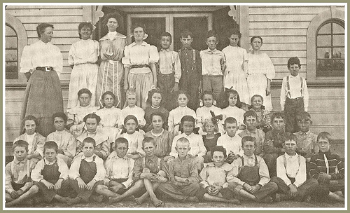
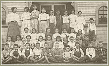 This is the Norwalk Grammar School in 1890 before 1900 in Norwalk, California. The picture is with teacher Cora Hargitt Johnson with her class. Hargitt School is named after her.
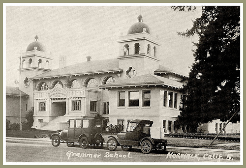
 The Norwalk Grammar School on Walnut Avenue in Norwalk, California in the 1920s.
The area known as "Norwalk" was first home to the Shoshonean Native American tribe. They survived primarily on honey, an array of berries, acorns, sage, squirrels, rabbits and birds. Their huts were part of the Sejat Indian village.
In the late 1760s, settlers and missions flourished under Spanish rule with the famous El Camino Real trail traversing the area. Manuel Nieto, a Spanish soldier, received a Spanish land grant (Rancho Los Nietos) in 1784 that included Norwalk.
After the Mexican-American War in 1848, the Rancho and mining days ended. Portions of the land were subdivided and made available for sale when California was admitted into the union of the United States. Word of this land development reached the Sproul Brothers in Oregon. They recalled the fertile land and huge sycamore trees they saw during an earlier visit to the Southern California area. In 1869, Atwood Sproul, on behalf of his brother, Gilbert, purchased 463 acres (1.87 km2) of land at $11 an acre ($2700/km²) in an area known as Corazon de los Valles, or "Heart of the Valleys."
By 1873, railroads were being built in the area and the Sprouls deeded 23 acres (93,000 m²) stipulating a "passenger stop" clause in the deed. Three days after the Anaheim Branch Railroad crossed the "North-walk" for the first time, Gilbert Sproul surveyed a town site. In 1874, the name was recorded officially as Norwalk. While a majority of the Norwalk countryside remained undeveloped during the 1880s, the Norwalk Station allowed potential residents the opportunity to visit the "country" from across the nation.
What are known as the "first families" to Norwalk (including the Sprouls, the Dewitts, the Settles, and the Orrs) settled in the area in the years before 1900. D.D. Johnston pioneered the first school system in Norwalk in 1880. Johnston was also responsible for the first real industry in town, a cheese factory, by furnishing Tom Lumbard with the money in 1882. Norwalk's prosperity was evident in the 1890s with the construction of a number of fine homes that were located in the middle of orchards, farms and dairies. Headstones for these families can be found at Little Lake Cemetery, which was founded in 1843 on the border between Norwalk and Santa Fe Springs at Lakeland Road.
At the turn of the 19th century, Norwalk had become established as a dairy center. Of the 50 local families reported in the 1900 census, most were associated with farming or with the dairy industry. Norwalk was also the home of some of the largest sugar beet farms in all of Southern California during this era. Many of the dairy farmers who settled in Norwalk during the early part of the 20th century were Dutch.
After the 1950s, the Hispanic population in Norwalk grew significantly as the area became increasingly residential. In the 1990s, Norwalk gained a significant Asian population from families priced out of wealthier neighboring Cerritos and communities in Orange County.
Airplane disaster
In February 1958, two military aircraft, a Douglas C-118 A military transport and a U.S. Navy P2V-5F Neptune patrol bomber, collided over Norwalk at night. 47 servicemen were killed as well as a civilian 23-year-old woman on the ground who was hit by falling debris. A plaque commemorating the disaster erected by the American Legion in 1961 marks the spot of the accident, today a mini-mall at the corner of Firestone Boulevard and Pioneer Boulevard.
The Hargitt House
Built in 1891 by the D. D. Johnston family, the Hargitt House was built in the architectural style of Victorian Eastlake. The Hargitt House Museum, located at 12426 Mapledale, was donated to the people of Norwalk by Charles ("Chun") and Ida Hargitt. The Museum is open on the first and third Saturday of the month from 1:00 p.m. to 4:00 p.m.
Emergency services
Fire protection in Norwalk is provided by the Los Angeles County Fire Department with ambulance transport by Care Ambulance Service.
The Los Angeles County Sheriff's Department operates the Norwalk Station in Norwalk.[13]
Economy
Top employers
According to the City's 2009 Comprehensive Annual Financial Report,[14] the top employers in the city are:
# Employer # of Employees 1 Norwalk-La Mirada Unified School District 4,365 2 Metropolitan State Hospital 1,532 3 Los Angeles County Registrar/Recorder 1,216 4 Cerritos College 1,198 5 Bally Total Fitness 650 6 City of Norwalk 469 7 Coast Plaza Hospital 432 8 Target 420 9 California Division of Juvenile Justice 342 10 Costco 318 11 Los Angeles County Department of Public Social Services 310 12 Doty Bros. Contstruction 300 13 Los Angeles County Sheriff's Department 250 14 McKenna Motors 230 15 Superior Court of Los Angeles County 225 16 Stater Bros. 160 17 Lowe's 150 18 Norwalk Toyota 135 19 AMC Norwalk 20 Theaters 130 20 Doubletree 100 21 Wal-Mart 100 22 Fresh & Easy 99 23 Norwalk Regional Library 70 24 Verizon 67 25 Outback Steakhouse 60 26 Sonoco 60 27 Food 4 Less 56 28 Los Angeles County Department of Public Health 37 29 Office Depot 30 Education
Norwalk is home to Cerritos College. Founded in 1955, Cerritos College is a public community college serving an area of 52 square miles (130 km2) of southeastern Los Angeles county. The college offers degrees and certificates in 87 areas of study in nine divisions. Over 1,200 students complete their course of studies each year.
Norwalk is served by the Norwalk-La Mirada Unified School District, headquartered at 12820 Pioneer Blvd., Norwalk, CA 90650 as well as the Little Lake City School District, headquartered in Santa Fe Springs. Certain areas of West Norwalk are served by the ABC Unified School District, based in Cerritos. Among the several parochial schools in Norwalk are Saint John of God School (Roman Catholic), Pioneer Baptist School (Baptist Christian), and Saint Linus School (Roman Catholic). It also contains The California distinguished school J.B. Morrison Elementary Magnet School.
Media
KCAL-TV channel 9, an independently-owned and operated television station, is originally licensed to Norwalk (formerly KHJ-TV not to be confused with subsidiary KHJ-AM radio station), but it represents Los Angeles and the entire Southern California region.
Famous residents of Norwalk
- Tiffany Darwish, 80's Teen Idol
- Poncho Sanchez, Latin jazz artist
- Pat Nixon Wife of President Richard M. Nixon; Excelsior High School Class of 1929 (Family bought a Truck Farm in Dairy Valley, formerly in Artesia, but now part of Cerritos)
- James Gattuso Analyst and pundit now in Washington, DC who often appears on television and radio to give opinions on domestic policy; Excelsior High School Class of 1975
- Cindy Sheehan, anti-Iraq War activist
- Bob Kevoian Radio Host "The Bob & Tom Show" Norwalk High Class of 1969
- Gene Taylor (musician) acclaimed blues-rock and Boogie Woogie pianist. Norwalk High Class of 1970
- Nikki Schieler Ziering, Playboy Playmate, actress and Ian Ziering's ex-wife
- William Conrad, Graduate of Excelsior High School; Actor, director and producer in film and television (b. 1920, d. 1994)
- Alexandra Nechita, Artist, considered the youngest cubist ever discovered (at the age of 8) and nicknamed "petite Picasso". Attended Moffit Elementary School prior to her fame when she relocated outside of Norwalk.
- Shirley Babashoff, Norwalk High School graduate, 1973 and Olympic Swim Team, 1972 and 1976.
- Dick Bass, born Richard Lee Bass, played professional football as a running back for the Los Angeles Rams from 1960 through 1969.
- Richard Brown Major League Baseball Player Los Angeles Dodgers 1990-93 Oakland Athletics 1993-96
- Keith Ginter, MLB player for the Houston Astros, Milwaukee Brewers, and the Oakland Athletics.
Movies and TV shows filmed in Norwalk
- The Postman Always Rings Twice - (1946) Includes scene filmed on location at the Norwalk train depot near Front Street and Funston Avenue
- Corvette Summer (1978) - Scene filmed outside of what was then the Golden West Ballroom on Studebaker between Imperial Highway and Firestone Boulevard
- Square Pegs (1982) - Filmed at Excelsior High School
- Grease 2 (1982) - Mostly filmed at Excelsior High School
- High School U.S.A. (1983) - Filmed at Excelsior High School
- CHiPs (1983) - Episode filmed in various parts of Norwalk
- Suburbia (1984) - Streetscape in the Interstate 105/605 area
- The Karate Kid (1984) - Golf 'N' Stuff
- Another Day in Paradise (1989) - Locations include both Front Street and Firestone Boulevard
- Cutting Class (1989 Horror Film) - Filmed in Norwalk, the movie was Brad Pitt's first major role in a movie. The John Glenn High School band is heard playing their school fight song during the game scene
- Speed (1994) - Shots filmed at the construction site of the 105 Freeway at Studebaker Rd and Imperial Hwy
- Things to Do in Denver When You're Dead (1995) - Outside scenes filmed at Keystone Lanes, a bowling alley on Imperial Highway
- Korn (1995) - "Shoots N' Ladders" music video was shot at Golf N' Stuff
- Best Men (1997) - Mostly filmed on Front Street
- Life (1999) - Scene filmed at Greyhound bus station on Front Street
- Frailty (2001) - Shots filmed at Greyhound bus station on Front Street at San Antonio Boulevard
- Monk (2004) - The scenes in the Mega-Mart storage area were recorded in the Big Lots at Norwalk Town Square.
- Avril Lavigne (2006) - "Girlfriend" music video was shot at Golf N' Stuff
- Heroes (TV series, 2007) - Scene filmed at Greyhound bus station on Front Street at San Antonio Boulevard
- Brüno (2009) - Civil Marriage Scene filmed at the LA County Registrar-Recorder/County Clerk Building.
Neighborhoods
- Carmenita (South Norwalk) [15]
- Civic Center (Central Norwalk) [16]
- Norwalk Hills (North Norwalk) [17]
- South Norwalk [18]
- Studebaker (North Norwalk) [19]
See also
- List of California public officials charged with crimes, Norwalk
References
- ^ U.S. Census
- ^ "US Gazetteer files: 2010, 2000, and 1990". United States Census Bureau. 2011-02-12. http://www.census.gov/geo/www/gazetteer/gazette.html. Retrieved 2011-04-23.
- ^ "CENSUS OF POPULATION AND HOUSING (1790–2000)". U.S. Census Bureau. http://www.census.gov/prod/www/abs/decennial/index.html. Retrieved 2010-07-30.
- ^ All data are derived from the United States Census Bureau reports from the 2010 United States Census, and are accessible on-line here. The data on unmarried partnerships and same-sex married couples are from the Census report DEC_10_SF1_PCT15. All other housing and population data are from Census report DEC_10_DP_DPDP1. Both reports are viewable online or downloadable in a zip file containing a comma-delimited data file. The area data, from which densities are calculated, are available on-line here. Percentage totals may not add to 100% due to rounding. The Census Bureau defines families as a household containing one or more people related to the householder by birth, opposite-sex marriage, or adoption. People living in group quarters are tabulated by the Census Bureau as neither owners nor renters. For further details, see the text files accompanying the data files containing the Census reports mentioned above.
- ^ "American FactFinder". United States Census Bureau. http://factfinder.census.gov. Retrieved 2008-01-31.
- ^ City of Norwalk 2007-08 CAFR Retrieved 2009-06-07
- ^ City of Norwalk Website retrieved 2009-06-04
- ^ http://www.lavote.net/GENERAL/About_Us.cfm
- ^ "Will Gerrymandered Districts Stem the Wave of Voter Unrest?". Campaign Legal Center Blog. http://www.clcblog.org/blog_item-85.html. Retrieved 2008-02-10.
- ^ "Whittier Health Center." Los Angeles County Department of Health Services. Retrieved on March 18, 2010.
- ^ "Post Office Location - NORWALK." United States Postal Service. Retrieved on December 6, 2008.
- ^ "Post Office Location - PADDISON SQUARE." United States Postal Service. Retrieved on December 6, 2008.
- ^ "Norwalk Station." Los Angeles County Sheriff's Department. Retrieved on January 21, 2010.
- ^ City of Norwalk CAFR
- ^ http://losangeles.blockshopper.com/neighborhoods/by_city/norwalk
- ^ http://losangeles.blockshopper.com/neighborhoods/by_city/norwalk
- ^ http://losangeles.blockshopper.com/neighborhoods/by_city/norwalk
- ^ http://losangeles.blockshopper.com/neighborhoods/by_city/norwalk
- ^ http://losangeles.blockshopper.com/neighborhoods/by_city/norwalk
External links
- City of Norwalk website
- Norwalk City, California
- Norwalk Chamber of Commerce
- LA County Disaster Communications Service ( DCS ) Norwalk Station
- Norwalk Municipal Code
- Norwalk QuickFacts from the US Census Bureau

Downey Santa Fe Springs Santa Fe Springs Bellflower 
Santa Fe Springs  Norwalk

Cerritos Artesia Cerritos Greater Los Angeles Area Central city Counties Satellite cities Cities
>200kCities and towns
100k–200kBurbank • Compton • Corona • Costa Mesa • Downey • East Los Angeles • El Monte • Fontana • Fullerton • Garden Grove • Inglewood • Lancaster • Mission Viejo • Moreno Valley • Murrieta • Norwalk • Ontario • Orange • Palmdale • Pasadena • Pomona • Rancho Cucamonga • Santa Clarita • Simi Valley • South Gate • Temecula • Thousand Oaks • Torrance • Ventura • Victorville • West CovinaArea regions Antelope Valley • Conejo Valley • Downtown Los Angeles • East Los Angeles • Gateway Cities • Greater Hollywood • Harbor Area • Inland Empire • Palos Verdes Hills • Pomona Valley • San Bernardino Valley • San Fernando Valley • San Gabriel Valley • Santa Ana Valley • Santa Clarita Valley • South Bay • South Los Angeles • Westside Los AngelesLandforms Los Angeles Basin • Baldwin Hills (range) • Calico Mountains • Catalina Island • Channel Islands • Coachella Valley • High Desert—Mojave Desert • Low Desert—Colorado Desert • San Fernando Valley • San Bernardino Mountains • San Gabriel Mountains • Santa Ana Mountains • Santa Monica Mountains • Santa Susana Mountains • Verdugo MountainsBodies of water Los Angeles River • Aliso Creek • Arroyo Seco • Ballona Creek • Bell Creek • Big Bear Lake • Coyote Creek • Lake Arrowhead • Lake Perris • Lake Piru • Malibu Creek • Pacific Ocean • Pyramid Lake • Rio Hondo • San Gabriel River • San Juan Creek • San Pedro Bay • Santa Ana River • Santa Clara River • Santa Margarita River • Santa Monica BayMayors of cities with populations exceeding 100,000 in California - Antonio Villaraigosa
(Los Angeles) - Jerry Sanders
(San Diego) - Chuck Reed
(San Jose) - Edwin M. Lee
(San Francisco) - Ashley Swearengin
(Fresno) - Kevin Johnson
(Sacramento) - Bob Foster
(Long Beach) - Jean Quan
(Oakland) - Harvey Hall
(Bakersfield) - Tom Tait
(Anaheim) - Miguel A. Pulido
(Santa Ana)
- Ronald O. Loveridge
(Riverside) - Ann Johnston
(Stockton) - Cheryl Cox
(Chula Vista) - Bob Wasserman
(Fremont) - Sukhee Kang
(Irvine) - Pat Morris
(San Bernardino) - Jim Ridenour
(Modesto) - Thomas E. Holden
(Oxnard) - Acquanetta Warren
(Fontana) - William H. Batey II
(Moreno Valley)^ - John Drayman
(Glendale)
- Cathy Green
(Huntington Beach)^ - Bob Kellar
(Santa Clarita)^ - William Dalton
(Garden Grove) - Susan Gorin
(Santa Rosa)^ - Jim Wood
(Oceanside) - Donald Kurth
(Rancho Cucamonga) - Paul S. Leon
(Ontario) - R. Rex Parris
(Lancaster) - Pat Hume
(Elk Grove) - James C. Ledford Jr.
(Palmdale) - Stan Skipworth
(Corona)^
- Dennis Donohue
(Salinas) - Elliot Rothman
(Pomona) - Frank Scotto
(Torrance) - Michael Sweeney
(Hayward) - Sam Abed
(Escondido) - Tony Spitaleri
(Sunnyvale) - Bill Bogaard
(Pasadena) - Carolyn Cavecche
(Orange) - F. Richard Jones
(Fullerton)^ - Jacqui Irwin
(Thousand Oaks)^ - Jesus Gamboa
(Visalia)
- Paul Miller
(Simi Valley) - William D. Shinn
(Concord)^ - Gina Garbolino
(Roseville) - Jamie L. Matthews
(Santa Clara) - Osby Davis
(Vallejo) - Rudy Cabriales
(Victorville) - Ernest Gutierrez
(El Monte) - Tom Bates
(Berkeley) - Rick Trejo
(Downey)^ - Eric R. Bever
(Costa Mesa)^ - James T. Butts, Jr.
(Inglewood)

^Mayor selected from city council
Other states: AL • AK • AZ • AR • CA • CO • CT • DE • FL • GA • HI • ID • IL • IN • IA • KS • KY • LA • ME • MD • MA • MI • MN • MS • MO • MT • NE • NV • NH • NJ • NM • NY • NC • ND • OH • OK • OR • PA • RI • SC • SD • TN • TX • UT • VT • VA • WA • WV • WI • WYCategories:- Cities in Los Angeles County, California
- Populated places in California with Hispanic majority populations
- Incorporated cities and towns in California
- Populated places established in 1957


Wikimedia Foundation. 2010.