- Lawndale, California
Infobox Settlement
official_name = City of Lawndale
other_name =
native_name =
nickname =
motto = Heart of the South Bay
imagesize =
image_caption =
flag_size =
image_
seal_size =
image_shield =
shield_size =
image_blank_emblem =
blank_emblem_size =
imagesize =
image_caption =
flag_size =
image_
seal_size =
image_shield =
shield_size =
image_blank_emblem =
blank_emblem_size =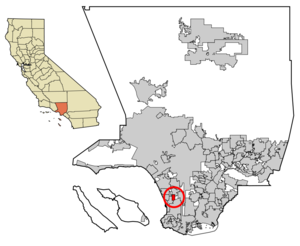
mapsize = 250x200px
map_caption = Location of Lawndale in Los Angeles County,California
mapsize1 =
map_caption1 =
subdivision_type = Country
subdivision_name =United States
subdivision_type1 = State
subdivision_name1 =California
subdivision_type2 = County
subdivision_name2 = Los Angeles
subdivision_type3 =
subdivision_name3 =
subdivision_type4 =
subdivision_name4 =
government_type =
leader_title =Mayor
leader_name = Harold Hofmann [cite web | url = http://www.lawndalecity.org/html/depthtml/council/council.htm | title = City of Lawndale - City Council | accessdate = 2007-01-18]
leader_title1 =
leader_name1 =
leader_title2 =
leader_name2 =
leader_title3 =
leader_name3 =
established_title =
established_date =
established_title2 =
established_date2 =
established_title3 = Incorporated (city)
established_date3 =1959-12-28 [cite web | url = http://www.cacities.org/resource_files/20457.IncorpDateLO.doc | title = Incorporation Dates of California Cities | accessdate = 2007-01-18]
area_magnitude =
area_total_km2 = 5.12
area_total_sq_mi = 1.98
area_land_km2 = 5.12
area_land_sq_mi = 1.98
area_water_km2 = 0.00
area_water_sq_mi = 0.00
area_water_percent = 0.00
area_urban_km2 =
area_urban_sq_mi =
area_metro_km2 =
area_metro_sq_mi =
population_as_of = 2000
population_note =
population_footnotes = [cite web | url = http://factfinder.census.gov/servlet/ACSSAFFFacts?_event=Search&geo_id=&_geoContext=&_street=&_county=&_cityTown=Lawndale%20city&_state=04000US06&_zip=&_lang=en&_sse=on&pctxt=fph&pgsl=010 | title = Lawndale city, California - Fact Sheet - American FactFinder | accessdate = 2007-01-18]
settlement_type =City
population_total = 31711
population_density_km2 = 6191.8
population_density_sq_mi = 16036.7
population_metro =
population_density_metro_km2 =
population_density_metro_sq_mi =
population_urban =
population_density_urban_km2 =
population_density_urban_sq_mi =
timezone = PST
utc_offset = -8
timezone_DST = PDT
utc_offset_DST = -7
latd = 33 |latm = 53 |lats = 12 |latNS = N
longd = 118 |longm = 21 |longs = 13 |longEW = W
elevation_m = 18
elevation_ft = 59
postal_code_type =ZIP Code
postal_code = 90260, 90261 [cite web | url = http://zip4.usps.com/zip4/zcl_1_results.jsp?visited=1&pagenumber=0&state=ca&city=Lawndale | title = USPS - ZIP Code Lookup - Find a ZIP+ 4 Code By City Results | accessdate = 2007-01-18]
area_code = 310/424 [cite web | url = http://www.nanpa.com/nas/public/npa_city_query_step2.do?method=displayData&cityToNpaModel.stateAbbr=CA&cityToNpaModel.city=Lawndale | title = Number Administration System - NPA and City/Town Search Results | accessdate = 2007-01-18]
website = [http://www.lawndalecity.org/ http://www.lawndalecity.org/]
blank_name = FIPS code
blank_info = 06-40886
blank1_name = GNIS feature ID
blank1_info = 1652742
footnotes =Lawndale is a city in Los Angeles County,
California ,United States . The population was 31,711 at the 2000 census.History
From the 1780s onward, the area that is now Lawndale was part of the "
El Rancho Sausal Redondo ", aland grant given by the Spanish colonial government that includes much of what is now the South Bay region. In 1905Charles B. Hopper first subdivided the area and named it after aChicago suburb. Lots sold slowly and different promotions were tried such as promoting Lawndale as a chicken raising area. The first railway to run through Lawndale was the Inglewood Division of the Redondo Railway which would later become part of thePacific Electric "Red Car" system. It ran down the middle of Railway Ave. (now Hawthorne Blvd.) until 1933. In 1927 the Santa Fe railroad arrived. AfterWorld War II , the immense demand for housing from returning veterans and California newcomers resulted in Lawndale's formation as abedroom community . In 1959 it was incorporated as a city.Starting in the 1970s Lawndale's relatively low housing prices but less desirable location relative to its neighboring cities attracted
absentee landlord s and a substantial portion of its residents increasingly became renters.For a time in the 1980s, with new cycle of expansion of
defense industry nearby, many young people who wished to live in the Beach Cities found that they simply could not afford to do so, and settled in less glamorous inland cities such as Lawndale. But with the contraction of this industry after thecold war , Lawndale reverted back to its previous pattern. Lawndale has attempted to attract more owner/residents, as well as tourists with the 2003 completion of anurban renewal project along the city's stretch of Hawthorne Boulevard (State Route 107), a major South Bay thoroughfare. This project called "Beautify Lawndale" has been an ongoing one that has cost the city several million dollars, and also yielded the new digital billboard located on Inglewood Ave.The billboard for its first 18 months was sponsored by Fox and promoted upcoming television shows and movies under the Fox label, but according to the director of Payroll for Fox Studios the ad campaign was removed due to, in their words, "Lawndale being too small of a city to warrant the costs". It also later gained and lost a sponsorship with Toyota, and now it is simply a huge white board, with the digital section underneath promoting local businesses.
Famous residents
*Roy Rogers and
Bettie Page once lived here for a short time.
*Fred Dryer grew up in Lawndale.
*Nnamdi Asomugha , currentNFL cornerback ,Oakland Raiders , attendedWilliam Green Elementary School andWill Rogers Middle School in Lawndale.
*The television showDrake and Josh takes place in Lawndale.chools
Lawndale Elementary School District [http://www.lawndale.k12.ca.us/]
*Will Rogers Middle School [http://www.lawndale.k12.ca.us/schools/school_details.php?location_id=12] , serving 6th, 7th and 8th grades
*Jane Addams Middle School
*F.D.R Elementary School
*William Anderson Elementary School
*William Green Elementary School
*Mark Twain Elementary School
*Billy Mitchell Elementary School
*Lucille J. Smith Elementary SchoolCentinela Valley Union High School District [http://www.centinela.k12.ca.us/]
*Lawndale High School [http://www.lawndalehs.org/]
*Leuzinger High School [http://www.leuzinger.org/]
*Lloyde High School [http://lloyde.centinela.k12.ca.us/]Environmental Charter High School [http://www.echsonline.org/] is acharter school in Lawndale.Geography
Lawndale is located at coor dms|33|53|12|N|118|21|13|W|city (33.886764, -118.353556)GR|1.
According to the
United States Census Bureau , the city has a total area of 5.1 km² (2.0 mi²), all land.Lawndale is bordered by Redondo Beach on the West and Southwest, Hawthorne on the North, Torrance on the Southeast, and
unincorporated area of El Camino Village (also know as Alondra Park) on the East.Demographics
As of the
census GR|2 of 2000, there were 31,711 people, 9,555 households, and 7,022 families residing in the city. Thepopulation density was 6,183.7/km² (16,036.7/mi²). There were 9,869 housing units at an average density of 1,924.5/km² (4,990.9/mi²). The racial makeup of the city was 42.24% White, 12.61% African American, 0.99% Native American, 9.63% Asian, 0.91% Pacific Islander, 27.07% from other races, and 6.55% from two or more races. Hispanic or Latino of any race were 52.08% of the population.There were 9,555 households out of which 45.5% had children under the age of 18 living with them, 45.8% were married couples living together, and 26.5% were non-families. 18.8% of all households were made up of individuals and 4.5% had someone living alone who was 65 years of age or older. The average household size was 3.31 and the average family size was 3.80.
In the city the population was spread out with 31.9% under the age of 18, 10.2% from 18 to 24, 35.8% from 25 to 44, 16.4% from 45 to 64, and 5.6% who were 65 years of age or older. The median age was 29 years. For every 100 females there were 102.3 males. For every 100 females age 18 and over, there were 99.1 males.
The median income for a household in the city was $39,012, and the median income for a family was $37,909. Males had a median income of $29,033 versus $29,025.00 for females. The
per capita income for the city was $13,702. About 14.3% of families and 17.3% of the population were below thepoverty line , including 22.4% of those under age 18 and 6.6% of those age 65 or over.Politics
In the state legislature Lawndale is located in the 25th Senate District, represented by Democrat
Edward Vincent , and in the 51st Assembly District, represented by DemocratCurren D. Price Jr. . Federally, Lawndale is located inCalifornia's 35th congressional district , which has a Cook PVI of D +33 [cite web | title = Will Gerrymandered Districts Stem the Wave of Voter Unrest? | publisher = Campaign Legal Center Blog | url=http://www.clcblog.org/blog_item-85.html | accessdate = 2008-02-10] and is represented by DemocratMaxine Waters .References
External links
* [http://www.lawndalecity.org/ Lawndale official website]
* [http://lacdcs.com/station-end-page-3.html LA County Disaster Communications Service ( DCS ) Lennox Station]
Wikimedia Foundation. 2010.