- North El Monte, California
-
North El Monte — census-designated place — Location of North El Monte in Los Angeles County, California.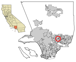
Coordinates: 34°6′11″N 118°1′24″W / 34.10306°N 118.02333°WCoordinates: 34°6′11″N 118°1′24″W / 34.10306°N 118.02333°W Country  United States
State  California
County Los Angeles Area[1] – Total 0.423 sq mi (1.096 km2) – Land 0.423 sq mi (1.096 km2) – Water 0 sq mi (0 km2) 0% Elevation 331 ft (101 m) Population (2010) – Total 3,723 – Density 8,801.4/sq mi (3,396.9/km2) Time zone PST (UTC-8) – Summer (DST) PDT (UTC-7) ZIP code 91006 Area code(s) 626 FIPS code 06-51820 GNIS feature ID 1867046 North El Monte is a census-designated place (CDP) in the San Gabriel Valley, in Los Angeles County, California, United States. The population was 3,723 at the 2010 census, up from 3,703 at the 2000 census.
Contents
Geography
North El Monte is located at 34°6′11″N 118°1′24″W / 34.10306°N 118.02333°W (34.102958, -118.023319),[2] or about two miles (3 km) north of El Monte.[3]
According to the United States Census Bureau, the CDP has a total area of 0.4 square miles (1.0 km2), all land.
Demographics
Historical populations Census Pop. %± 1990 3,384 — 2000 3,703 9.4% 2010 3,723 0.5% sources:[4] 2010
The 2010 United States Census[5] reported that North El Monte had a population of 3,723. The population density was 8,794.7 people per square mile (3,395.7/km²). The racial makeup of North El Monte was 1,768 (47.5%) White, 33 (0.9%) African American, 13 (0.3%) Native American, 1,437 (38.6%) Asian, 4 (0.1%) Pacific Islander, 336 (9.0%) from other races, and 132 (3.5%) from two or more races. Hispanic or Latino of any race were 1,002 persons (26.9%).
The Census reported that 3,669 people (98.5% of the population) lived in households, 0 (0%) lived in non-institutionalized group quarters, and 54 (1.5%) were institutionalized.
There were 1,254 households, out of which 426 (34.0%) had children under the age of 18 living in them, 747 (59.6%) were opposite-sex married couples living together, 163 (13.0%) had a female householder with no husband present, 56 (4.5%) had a male householder with no wife present. There were 46 (3.7%) unmarried opposite-sex partnerships, and 5 (0.4%) same-sex married couples or partnerships. 218 households (17.4%) were made up of individuals and 99 (7.9%) had someone living alone who was 65 years of age or older. The average household size was 2.93. There were 966 families (77.0% of all households); the average family size was 3.31.
The population was spread out with 742 people (19.9%) under the age of 18, 301 people (8.1%) aged 18 to 24, 962 people (25.8%) aged 25 to 44, 1,109 people (29.8%) aged 45 to 64, and 609 people (16.4%) who were 65 years of age or older. The median age was 42.2 years. For every 100 females there were 92.1 males. For every 100 females age 18 and over, there were 90.6 males.
There were 1,304 housing units at an average density of 3,080.4 per square mile (1,189.3/km²), of which 945 (75.4%) were owner-occupied, and 309 (24.6%) were occupied by renters. The homeowner vacancy rate was 0.6%; the rental vacancy rate was 5.2%. 2,761 people (74.2% of the population) lived in owner-occupied housing units and 908 people (24.4%) lived in rental housing units.
2000
As of the census[6] of 2000, there were 3,703 people, 1,270 households, and 994 families residing in the CDP. The population density was 8,751.9 inhabitants per square mile (3,404.1/km²). There were 1,302 housing units at an average density of 3,077.2 per square mile (1,196.9/km²). The racial makeup of the CDP was 49.76% White, 0.76% African American, 0.27% Native American, 52.17% Asian, 0.05% Pacific Islander, 10.21% from other races, and 2.78% from two or more races. Hispanic or Latino of any race were 15.28% of the population.
There were 1,270 households out of which 32.8% had children under the age of 18 living with them, 61.0% were married couples living together, 11.5% had a female householder with no husband present, and 21.7% were non-families. 17.9% of all households were made up of individuals and 8.6% had someone living alone who was 65 years of age or older. The average household size was 2.87 and the average family size was 3.23.
In the CDP the population was spread out with 23.0% under the age of 18, 6.9% from 18 to 24, 29.9% from 25 to 44, 23.8% from 45 to 64, and 16.4% who were 65 years of age or older. The median age was 39 years. For every 100 females there were 91.8 males. For every 100 females age 18 and over, there were 88.6 males.
The median income for a household in the CDP was $48,583, and the median income for a family was $80,000. Males had a median income of $45,195 versus $28,125 for females. The per capita income for the CDP was $19,192. About 6.2% of families and 7.4% of the population were below the poverty line, including 14.4% of those under age 18 and 4.5% of those age 65 or over.
Government
In the state legislature North El Monte is located in the 29th Senate District, represented by Republican Bob Huff, and in the 49th Assembly District, represented by Democrat Mike Eng. Federally, North El Monte is located in California's 26th congressional district, which has a Cook PVI of R +4[7] and is represented by Republican David Dreier.
References
- ^ U.S. Census
- ^ "US Gazetteer files: 2010, 2000, and 1990". United States Census Bureau. 2011-02-12. http://www.census.gov/geo/www/gazetteer/gazette.html. Retrieved 2011-04-23.
- ^ http://www.city-data.com/city/North-El-Monte-California.html city-data.com
- ^ "CENSUS OF POPULATION AND HOUSING (1790-2000)". U.S. Census Bureau. http://www.census.gov/prod/www/abs/decennial/index.html. Retrieved 2010-07-17.
- ^ All data are derived from the United States Census Bureau reports from the 2010 United States Census, and are accessible on-line here. The data on unmarried partnerships and same-sex married couples are from the Census report DEC_10_SF1_PCT15. All other housing and population data are from Census report DEC_10_DP_DPDP1. Both reports are viewable online or downloadable in a zip file containing a comma-delimited data file. The area data, from which densities are calculated, are available on-line here. Percentage totals may not add to 100% due to rounding. The Census Bureau defines families as a household containing one or more people related to the householder by birth, opposite-sex marriage, or adoption. People living in group quarters are tabulated by the Census Bureau as neither owners nor renters. For further details, see the text files accompanying the data files containing the Census reports mentioned above.
- ^ "American FactFinder". United States Census Bureau. http://factfinder.census.gov. Retrieved 2008-01-31.
- ^ "Will Gerrymandered Districts Stem the Wave of Voter Unrest?". Campaign Legal Center Blog. http://www.clcblog.org/blog_item-85.html. Retrieved 2008-02-10.
Greater Los Angeles Area Central city Counties Satellite cities Cities
>200kCities and towns
100k–200kBurbank • Compton • Corona • Costa Mesa • Downey • East Los Angeles • El Monte • Fontana • Fullerton • Garden Grove • Inglewood • Lancaster • Mission Viejo • Moreno Valley • Murrieta • Norwalk • Ontario • Orange • Palmdale • Pasadena • Pomona • Rancho Cucamonga • Santa Clarita • Simi Valley • South Gate • Temecula • Thousand Oaks • Torrance • Ventura • Victorville • West CovinaArea regions Antelope Valley • Conejo Valley • Downtown Los Angeles • East Los Angeles • Gateway Cities • Greater Hollywood • Harbor Area • Inland Empire • Palos Verdes Hills • Pomona Valley • San Bernardino Valley • San Fernando Valley • San Gabriel Valley • Santa Ana Valley • Santa Clarita Valley • South Bay • South Los Angeles • Westside Los AngelesLandforms Los Angeles Basin • Baldwin Hills (range) • Calico Mountains • Catalina Island • Channel Islands • Coachella Valley • High Desert—Mojave Desert • Low Desert—Colorado Desert • San Fernando Valley • San Bernardino Mountains • San Gabriel Mountains • Santa Ana Mountains • Santa Monica Mountains • Santa Susana Mountains • Verdugo MountainsBodies of water Los Angeles River • Aliso Creek • Arroyo Seco • Ballona Creek • Bell Creek • Big Bear Lake • Coyote Creek • Lake Arrowhead • Lake Perris • Lake Piru • Malibu Creek • Pacific Ocean • Pyramid Lake • Rio Hondo • San Gabriel River • San Juan Creek • San Pedro Bay • Santa Ana River • Santa Clara River • Santa Margarita River • Santa Monica BayCategories:- Communities in the San Gabriel Valley
- Census-designated places in Los Angeles County, California
- Populated places in the United States with Asian plurality populations


Wikimedia Foundation. 2010.