- Cudahy, California
-
City of Cudahy — City — 
LogoLocation of Cudahy in Los Angeles County, California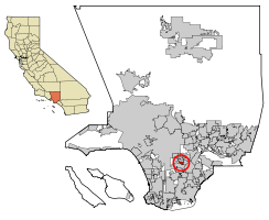
Coordinates: 33°57′51″N 118°10′57″W / 33.96417°N 118.1825°WCoordinates: 33°57′51″N 118°10′57″W / 33.96417°N 118.1825°W Country  United States
State  California
County Los Angeles Incorporated (city) November 10, 1960[1] Area[2] - Total 1.226 sq mi (3.175 km2) - Land 1.175 sq mi (3.043 km2) - Water 0.051 sq mi (0.132 km2) 4.15% Elevation 121 ft (37 m) Population (2010 census) - Total 23,805 - Density 19,418.8/sq mi (7,497.6/km2) Time zone PST (UTC-8) - Summer (DST) PDT (UTC-7) ZIP Code 90201 Area code(s) 323 FIPS code 06-17498 GNIS feature ID 1652694 Website http://www.cudahy.ca.us/ Cudahy (
 /ˈkʌdəheɪ/ kud-ə-hay or /ˈkuːdəhaɪ/ koo-də-hy) is a city located in southeastern Los Angeles County, California. In terms of area, Cudahy is the second smallest city in Los Angeles County, after Hawaiian Gardens. with one of the highest population densities of any incorporated city in the United States. It is part of the Gateway Cities region.
Cudahy is populated predominantly by Latino immigrants[3] and has a population of 23,805 as of the 2010 Census[4]
Contents
History
Cudahy is named for its founder, meat-packing baron Michael Cudahy,[5] who purchased the original 2,777 acres (11.2 km2) of Rancho San Antonio in 1908 to resell as 1-acre (4,000 m2) lots.[citation needed] These "Cudahy lots" were notable for their dimensions—in most cases, 50 to 100 feet (15 to 30 m) in width and 600 to 800 feet (183 to 244 m) in depth, a length equivalent to a city block or more in most American towns. Such parcels, often referred to as "railroad lots", were intended to allow the new town's residents to keep a large vegetable garden, a grove of fruit trees (usually citrus), and a chicken coop or horse stable. This arrangement, popular in the towns along the lower Los Angeles and San Gabriel rivers, proved particularly attractive to the Southerners and Midwesterners who were leaving their struggling farms in droves in the 1910s and 1920s to start new lives in Southern California.[citation needed] Sam Quinones of the Los Angeles Times said that the large, narrow parcels of land gave Cudahy Acres a "rural feel in an increasingly urban swath."[5] As late as the 1950s, some Cudahy residents were still riding into the city's downtown areas on horseback.[citation needed] After World War II the city was a White American blue collar town with steel and automobile plants in the area.[5]
By the late 1970s, the factories closed down and the white American residents of Cudahy left for jobs and housing in the San Gabriel and San Fernando Valleys. Stucco apartment complexes were built on former tracts of land. The population density increased; in 2007 the city was the second-densest in California, after Maywood.[6]
Geography
Cudahy is located at 33°57′51″N 118°10′57″W / 33.964214°N 118.182575°W.[7]
According to the United States Census Bureau, the city has a total area of 3.175 square kilometers (1.226 sq mi), over 95% of it land.[8]
Cudahy is bordered by Bell on the north, Bell Gardens on the east, South Gate on the south and southwest, and Huntington Park on the west.
In 2007, of the 5,800 housing units, 5,000 were rentals.[6]
Demographics
2010
The 2010 United States Census[9] reported that Cudahy had a population of 23,805. The population density was 19,417.5 people per square mile (7,497.2/km²). The racial makeup of Cudahy was 11,708 (49.2%) White, 333 (1.4%) African American, 246 (1.0%) Native American, 137 (0.6%) Asian, 24 (0.1%) Pacific Islander, 10,339 (43.4%) from other races, and 1,018 (4.3%) from two or more races. Hispanic or Latino of any race were 22,850 persons (96.0%).
The Census reported that 23,797 people (100% of the population) lived in households, 8 (0%) lived in non-institutionalized group quarters, and 0 (0%) were institutionalized.
There were 5,607 households, out of which 3,712 (66.2%) had children under the age of 18 living in them, 2,941 (52.5%) were opposite-sex married couples living together, 1,362 (24.3%) had a female householder with no husband present, 686 (12.2%) had a male householder with no wife present. There were 589 (10.5%) unmarried opposite-sex partnerships, and 42 (0.7%) same-sex married couples or partnerships. 399 households (7.1%) were made up of individuals and 176 (3.1%) had someone living alone who was 65 years of age or older. The average household size was 4.24. There were 4,989 families (89.0% of all households); the average family size was 4.32.
The population was spread out with 8,325 people (35.0%) under the age of 18, 2,858 people (12.0%) aged 18 to 24, 7,279 people (30.6%) aged 25 to 44, 4,121 people (17.3%) aged 45 to 64, and 1,222 people (5.1%) who were 65 years of age or older. The median age was 27.0 years. For every 100 females there were 98.3 males. For every 100 females age 18 and over, there were 95.5 males.
There were 5,770 housing units at an average density of 4,706.5 per square mile (1,817.2/km²), of which 1,011 (18.0%) were owner-occupied, and 4,596 (82.0%) were occupied by renters. The homeowner vacancy rate was 1.3%; the rental vacancy rate was 2.3%. 4,355 people (18.3% of the population) lived in owner-occupied housing units and 19,442 people (81.7%) lived in rental housing units.
2000
As of the census[10] of 2000, there were 24,208 people, 5,419 households, and 4,806 families residing in the city. The population density was 21,627.7 inhabitants per square mile (8,345.3/km²). There were 5,542 housing units at an average density of 4,951.3 per square mile (1,910.5/km²). The racial makeup of the city was 43.14% White, 1.24% Black or African American, 1.28% Native American, 0.74% Asian, 0.17% Pacific Islander, 48.06% from other races, and 5.37% from two or more races. 94.14% of the population were Hispanic or Latino of any race.
There were 5,419 households out of which 66.0% had children under the age of 18 living with them, 57.6% were married couples living together, 21.7% had a female householder with no husband present, and 11.3% were non-families. 8.1% of all households were made up of individuals and 3.5% had someone living alone who was 65 years of age or older. The average household size was 4.47 and the average family size was 4.58.
In the city the population was spread out with 39.9% under the age of 18, 12.4% from 18 to 24, 32.3% from 25 to 44, 11.7% from 45 to 64, and 3.7% who were 65 years of age or older. The median age was 24 years. For every 100 females there were 97.7 males. For every 100 females age 18 and over, there were 97.4 males.
The median income for a household in the city was $29,040, and the median income for a family was $28,833. Males had a median income of $19,149 versus $16,042 for females. The per capita income for the city was $8,688. About 26.4% of families and 28.3% of the population were below the poverty line, including 34.1% of those under age 18 and 18.1% of those age 65 or over.
Government and infrastructure
In the state legislature Cudahy is located in the 30th Senate District, represented by Democrat Ronald S. Calderon, and in the 50th Assembly District, represented by Democrat Ricardo Lara. Federally, Cudahy is located in California's 34th congressional district, which has a Cook PVI of D +23[11] and is represented by Democrat Lucille Roybal-Allard.
Police Services formerly were contracted through the City of Maywood, by the Maywood-Cudahy Police Department, now disbanded. In an emergency meeting conducted July 21, 2010, Cudahy city leaders agreed to contract for police services with the Los Angeles County Sheriff's Department.[12]
Fire protection in Cudahy is provided by the Los Angeles County Fire Department.
The Los Angeles County Department of Health Services operates the Whittier Health Center in Whittier, serving Cudahy.[13]
The United States Postal Service Cudahy Post Office is located at 1619 Elizabeth Street.[14]
Economy
After World War II the population of Cudahy worked for plants operated by General Motors, Chrysler, Firestone, and Bethlehem Steel.[5] In 2007 the largest employers in Cudahy were the Kmart/Big Lots Center and the Superior Super Warehouse.[6]
Education
Cudahy is a part of the Los Angeles Unified School District. Cudahy is served by several schools, including Teresa Hughes Elementary School, Park Avenue Elementary School, Elizabeth Learning Center (a neighborhood school for grades K-8 and a high school for grades 9 through 12), Ochoa Learning Center (K-8), and Bell High School in Bell.
All residents are zoned to Bell High School.[15][16] Any student who lives in the Bell or Huntington Park High School zones may apply to Maywood Academy High School; Maywood Academy, which opened in 2005 and moved into its permanent campus in 2006, does not have its own attendance boundary because it lacks American football, track and field, and tennis facilities.[17]
South Region Elementary School 3 will open in Cudahy in 2010.[18]
Public libraries
County of Los Angeles Public Library operates the Cudahy Library at 5218 Santa Ana Street.[19]
See also
References
- ^ "Incorporation Dates of California Cities". http://www.cacities.org/resource_files/20457.IncorpDateLO.doc. Retrieved 2007-01-18.
- ^ U.S. Census
- ^ City of Cudahy (2009-07-06). The City of Cudahy – About the City. Retrieved on 2009-07-06 from http://www.cudahy.ca.us/about/about.asp.
- ^ City of Cudahy. Los Angeles Almanac. Retrieved 2011-05-27.
- ^ a b c d Quinones, Sam. "Novices threaten Cudahy's status quo." Los Angeles Times. January 2, 2007. 1. Retrieved on October 26, 2009.
- ^ a b c Quinones, Sam. "Novices threaten Cudahy's status quo." Los Angeles Times. January 2, 2007. 2. Retrieved on October 26, 2009.
- ^ "US Gazetteer files: 2010, 2000, and 1990". United States Census Bureau. 2011-02-12. http://www.census.gov/geo/www/gazetteer/gazette.html. Retrieved 2011-04-23.
- ^ [1]
- ^ All data are derived from the United States Census Bureau reports from the 2010 United States Census, and are accessible on-line here. The data on unmarried partnerships and same-sex married couples are from the Census report DEC_10_SF1_PCT15. All other housing and population data are from Census report DEC_10_DP_DPDP1. Both reports are viewable online or downloadable in a zip file containing a comma-delimited data file. The area data, from which densities are calculated, are available on-line here. Percentage totals may not add to 100% due to rounding. The Census Bureau defines families as a household containing one or more people related to the householder by birth, opposite-sex marriage, or adoption. People living in group quarters are tabulated by the Census Bureau as neither owners nor renters. For further details, see the text files accompanying the data files containing the Census reports mentioned above.
- ^ "American FactFinder". United States Census Bureau. http://factfinder.census.gov. Retrieved 2008-01-31.
- ^ "Will Gerrymandered Districts Stem the Wave of Voter Unrest?". Campaign Legal Center Blog. http://www.clcblog.org/blog_item-85.html. Retrieved 2008-02-10.
- ^ . http://latimesblogs.latimes.com/lanow/2010/06/cudahy-to-contract-police-services-with-sheriffs.htm.[dead link]
- ^ "Whittier Health Center." Los Angeles County Department of Health Services. Retrieved on March 18, 2010.
- ^ "Post Office Location – CUDAHY." United States Postal Service. Retrieved on December 6, 2008.
- ^ "Cudahy city, California." U.S. Census Bureau. Retrieved on July 2, 2010.
- ^ "Proposed Changes to South East HS Area Schools." Los Angeles Unified School District. Retrieved on June 24, 2010.
- ^ "School History." Maywood Academy High School. Retrieved on July 2, 2010.
- ^ http://www.laschools.org/project-status/one-project?project_number=56.40016 Los Angeles Unified School District Project Status Website
- ^ "Cudahy Library." County of Los Angeles Public Library. Retrieved on December 6, 2008.
External links
Greater Los Angeles Area Central city Counties Satellite cities Cities
>200kCities and towns
100k–200kBurbank • Compton • Corona • Costa Mesa • Downey • East Los Angeles • El Monte • Fontana • Fullerton • Garden Grove • Inglewood • Lancaster • Mission Viejo • Moreno Valley • Murrieta • Norwalk • Ontario • Orange • Palmdale • Pasadena • Pomona • Rancho Cucamonga • Santa Clarita • Simi Valley • South Gate • Temecula • Thousand Oaks • Torrance • Ventura • Victorville • West CovinaArea regions Antelope Valley • Conejo Valley • Downtown Los Angeles • East Los Angeles • Gateway Cities • Greater Hollywood • Harbor Area • Inland Empire • Palos Verdes Hills • Pomona Valley • San Bernardino Valley • San Fernando Valley • San Gabriel Valley • Santa Ana Valley • Santa Clarita Valley • South Bay • South Los Angeles • Westside Los AngelesLandforms Los Angeles Basin • Baldwin Hills (range) • Calico Mountains • Catalina Island • Channel Islands • Coachella Valley • High Desert—Mojave Desert • Low Desert—Colorado Desert • San Fernando Valley • San Bernardino Mountains • San Gabriel Mountains • Santa Ana Mountains • Santa Monica Mountains • Santa Susana Mountains • Verdugo MountainsBodies of water Los Angeles River • Aliso Creek • Arroyo Seco • Ballona Creek • Bell Creek • Big Bear Lake • Coyote Creek • Lake Arrowhead • Lake Perris • Lake Piru • Malibu Creek • Pacific Ocean • Pyramid Lake • Rio Hondo • San Gabriel River • San Juan Creek • San Pedro Bay • Santa Ana River • Santa Clara River • Santa Margarita River • Santa Monica BayCategories:- Cities in Los Angeles County, California
- Populated places in California with Hispanic majority populations
- Cudahy family
- Incorporated cities and towns in California
- Populated places established in 1960


Wikimedia Foundation. 2010.