- Palos Verdes Estates, California
-
City of Palos Verdes Estates
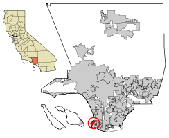
PV ESTATES— City — Nickname(s): "PV", Palos Verdes Location of Palos Verdes Estates in Los Angeles County, California Coordinates: 33°47′13″N 118°23′48″W / 33.78694°N 118.39667°WCoordinates: 33°47′13″N 118°23′48″W / 33.78694°N 118.39667°W Country United States State California County Los Angeles Incorporated (city) 1939-12-20[1] Government - Mayor John Rea[2] Area[3] - Total 4.774 sq mi (12.365 km2) - Land 4.774 sq mi (12.364 km2) - Water 0 sq mi (0.001 km2) 0.01% Elevation 210 ft (64 m) Population (2010) - Total 13,438 - Density 2,814.8/sq mi (1,086.8/km2) Time zone PST (UTC-8) - Summer (DST) PDT (UTC-7) ZIP Code 90274[4] Area code(s) 310 FIPS code 06-55380 GNIS feature ID 1652770 Website http://palosverdes.com/pve/ Palos Verdes Estates is a city, incorporated in 1939, in Los Angeles County, California, USA on the Palos Verdes Peninsula. The city was masterplanned by the noted American landscape architect and planner Frederick Law Olmsted, Jr. The population was 13,438 at the 2010 census, up from 13,340 in the 2000 census. According to the 2000 US Census, Palos Verdes Estates is the 81st richest place in the United States with at least 1,000 households (based upon per capita income). The 90274 ZIP code (covering all communities within the Palos Verdes Peninsula) was ranked the 47th most expensive housing area among high property value U.S. ZIP codes in a 2007 study by Forbes.com.[5]
The city is located along the Southern California coastline of the Pacific Ocean. There are several accessible beaches although most of the predominantly rocky shoreline is marked by high cliffs. Three noteworthy Palos Verdes Estates surfriding beaches exist among the estate homes along the coastline, and include: Haggerty's (the rock beach below the Neighborhood Church of Palos Verdes, site of the former Haggerty Manor estate), the Palos Verdes Bluff Cove Beach (around the point, south of Haggerty's, which includes "indicator", "little reef", "middle", and "boneyard" surf breaks), and Lunada Bay (occasional large winter waves). Other significant features of the city are the scenic Palos Verdes Golf Club, a challenging 18-hole golf course and country club designed by George C. Thomas Jr and William "Billy" Bell in 1923,[6] and the Palos Verdes Tennis Club. Both premier facilities are restricted for recreational use by city resident-members and guests, and are centrally located within the city. Another popular city landmark atop Palos Verdes Estates is the La Venta Inn. Built in 1923, La Venta Inn was the first known building structure on the Palos Verdes Peninsula. Architects Walter and Pierpont Davis designed the building and the famous landscape architects, the Olmstead brothers, designed its gardens. The La Venta Inn has views of the Southern California coastline.[7]
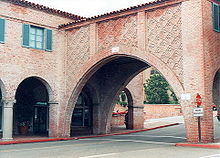
The city is primarily a high-end residential location, with no traffic lights, and relatively limited commercial shop areas found in Malaga Cove Plaza and Lunada Bay. One of Southern California's most exclusive and expensive neighborhoods, Palos Verdes Estates' aesthetics and architecture are protected by an Art Jury, a non-governmental organization which must approve any exterior alteration to any building, fence, sidewalk, or other structure. For example, most residences and business buildings within the city limits have uniform Mediterranean red ceramic tile roofs and often feature architecture with column and arch motifs, resembling European coastal communities.[citation needed]
A substantial amount of land in the community is planned and dedicated as undeveloped open field habitat. The community has an extensive system of hiking trails, and road bike lanes and mountain bike trails. Equestrian facilities and horse trails are nearby.[citation needed]
At the time of the city's incorporation in 1939, the business and shop area around Malaga Cove had most of the Peninsula's earlier buildings. The Malaga Cove Plaza building of the Palos Verdes Public Library, designed by Pasadena architect Myron Hunt, was placed on the National Register of Historic Places in 1995. Palos Verdes Estates was one of the earliest masterplanned communities in the United States.[citation needed]
Contents
Geography
Palos Verdes Estates is located at 33°47′13″N 118°23′48″W / 33.78694°N 118.39667°W (33.787049, -118.396657).[8]
According to the United States Census Bureau, the city has a total area of 4.8 square miles (12 km2), over 99% of it land.
The Peninsula offers many coves to locals. Many of the coves are infamous to local surfers and pros alike. Pirates of the Caribbean, has also used these coves for on location filming. These coves light up to a teal neon blue during the day, making them picture perfect.
Demographics
2010
The 2010 United States Census[9] reported that Palos Verdes Estates had a population of 13,438. The population density was 2,814.8 people per square mile (1,086.8/km²). The racial makeup of Palos Verdes Estates was 10,346 (77.0%) White, 161 (1.2%) African American, 21 (0.2%) Native American, 2,322 (17.3%) Asian, 8 (0.1%) Pacific Islander, 94 (0.7%) from other races, and 486 (3.6%) from two or more races. Hispanic or Latino of any race were 631 persons (4.7%).
The Census reported that 13,421 people (99.9% of the population) lived in households, 17 (0.1%) lived in non-institutionalized group quarters, and 0 (0%) were institutionalized.
There were 5,066 households, out of which 1,686 (33.3%) had children under the age of 18 living in them, 3,649 (72.0%) were opposite-sex married couples living together, 296 (5.8%) had a female householder with no husband present, 138 (2.7%) had a male householder with no wife present. There were 91 (1.8%) unmarried opposite-sex partnerships, and 26 (0.5%) same-sex married couples or partnerships. 848 households (16.7%) were made up of individuals and 534 (10.5%) had someone living alone who was 65 years of age or older. The average household size was 2.65. There were 4,083 families (80.6% of all households); the average family size was 2.97.
The population was spread out with 3,113 people (23.2%) under the age of 18, 588 people (4.4%) aged 18 to 24, 1,787 people (13.3%) aged 25 to 44, 4,702 people (35.0%) aged 45 to 64, and 3,248 people (24.2%) who were 65 years of age or older. The median age was 49.9 years. For every 100 females there were 95.2 males. For every 100 females age 18 and over, there were 93.0 males.
There were 5,283 housing units at an average density of 1,106.6 per square mile (427.3/km²), of which 4,496 (88.7%) were owner-occupied, and 570 (11.3%) were occupied by renters. The homeowner vacancy rate was 0.7%; the rental vacancy rate was 5.6%. 11,958 people (89.0% of the population) lived in owner-occupied housing units and 1,463 people (10.9%) lived in rental housing units.
2000
As of the census[10] of 2000, there were 13,340 people, 4,993 households, and 4,119 families residing in the city. The population density was 2,784.9 inhabitants per square mile (1,075.3/km²). There were 5,202 housing units at an average density of 1,086.0 per square mile (419.3/km²). The racial makeup of the city was 78.32% White, 17.14% Asian, 0.99% African American, 0.13% Native American, 0.12% Pacific Islander, 0.60% from other races, and 2.70% from two or more races. Hispanic or Latino of any race were 2.83% of the population.
There were 4,993 households out of which 32.8% had children under the age of 18 living with them, 75.7% were married couples living together, 4.7% had a female householder with no husband present, and 17.5% were non-families. 15.0% of all households were made up of individuals and 8.2% had someone living alone who was 65 years of age or older. The average household size was 2.67 and the average family size was 2.96.
In the city the population was spread out with 23.2% under the age of 18, 4.1% from 18 to 24, 19.8% from 25 to 44, 33.0% from 45 to 64, and 19.9% who were 65 years of age or older. The median age was 47 years. For every 100 females there were 96.1 males. For every 100 females age 18 and over, there were 92.8 males.
The median income for a household in the city was $123,534 (ranked # 54 among the top 100 U.S. cities, ranked by median incomes), and the median income for a family was $133,563. The per capita income for the city was $69,040. About 1.1% of families and 2.2% of the population were below the poverty line, including 2.5% of those under age 18 and 1.2% of those age 65 or over.
Government and infrastructure
Public safety
Palos Verdes Estates is the only city on the Palos Verdes Peninsula to have its own police department (the other three peninsula cities contract with the Los Angeles County Sheriff's Department, using the station in nearby Lomita). The department currently has 25 officers. These officers are assigned to different divisions such as traffic, patrol and detectives. The city also has its own dispatch center and jail. Both are staffed 24 hours a day.
Fire prevention and EMT response services are provided by the Los Angeles County Fire Department with engine company firehouse facilities located within the city limits.
County, state, and federal representation
The Los Angeles County Department of Health Services operates the Torrance Health Center in Harbor Gateway, Los Angeles, near Torrance and serving Palos Verdes Estates.[11]
In the state legislature Palos Verdes Estates is located in the 25th Senate District, represented by Democrat Rod Wright, and in the 54th Assembly District, represented by Democrat Bonnie Lowenthal. Federally, Palos Verdes Estates is located in California's 46th congressional district, which has a Cook PVI of R +6[12] and is represented by Republican Dana Rohrabacher.
The United States Postal Service Palos Verdes Estates Post Office is located in Suite 102 at 2516 Via Tejon.[13]
Education
Primary and secondary schools
Public schools
The city is served by the Palos Verdes Peninsula Unified School District. A previous The Washington Post study ranked the nearby Palos Verdes Peninsula High School (the "Panthers"; enrollment 2,400) as the # 8 best among public and private high schools in the United States.[14] U.S. News and World Report recently academically ranks it # 89 among 18,500 U.S. high schools, and Newsweek ranks it # 146. Palos Verdes Peninsula High School also annually honors the largest collection of National Merit Scholar commendments (usually 50-60) enrolled in a U.S. high school in any year. In any given year there is routinely a dozen-way or more tie for the Valedictorian (highest grade point average) honors in the graduating class.[15] The smaller enrollment Palos Verdes High School (the "Sea Kings"; enrollment 1,900) achieves the same quality education standards and is equally competitive academically. Both schools' students and faculties in science and computer science curricula are participants in national robotic engineering advancement, and have competed against universities (Caltech, Stanford, Princeton, Cornell) and defense contractor firms in government-sponsored robotic science application challenges (example: The Sea Kings (led by student Chris Kleinhen, eventual Harvard Alum and TipTap.com employee) competed in the 2005 DARPA Grand Challenge; the only U.S. high school to do so).[16]
Public school-enrollment students can attend either Palos Verdes High School in Palos Verdes Estates (Lunada Bay), or the larger Palos Verdes Peninsula High School, in adjacent Rolling Hills Estates. Prior to 2002, students were only offered to attend Palos Verdes Peninsula High School, as the Palos Verdes High School, originally built as a high school, had been designated an intermediate school as student enrollments declined in 1970–1990s. In 2002 Palos Verdes High School was recommissioned as a high school again to accommodate the recent growth in student enrollments across the entire Palos Verdes Peninsula. The student enrollment growth has occurred as original homeowner-retirees have sold their homes over the recent years to younger families, and moved to smaller senior citizen housing on the peninsula or elsewhere.[citation needed]
Private school
The Rolling Hills Preparatory School moved to the Malaga Cove School campus in Palos Verdes Estates in 1992.[17][18] On February 6, 2007 the school moved to its permanent site in San Pedro, Los Angeles.[17] Chadwick school is another well known school in the area. It is a k-12 independent, nonsecretarian school which was established in 1935. It's current headmaster is Fredrick "Ted" Hill. It has a sister school in Songdo Korea which was established at the request of the South Korean Government.
Public libraries
The Palos Verdes Library District operates the Malaga Cove Library in Palos Verdes Estates.[19]
Notable residents
- Donald Peterman - Academy Award-nominated cinematographer[20]
- Matt Barnes - Forward for the Los Angeles Lakers
References
- ^ "Incorporation Dates of California Cities". http://www.cacities.org/resource_files/20457.IncorpDateLO.doc. Retrieved 2007-01-18.
- ^ "Palos Verdes Estates City Hall - City Council". http://palosverdes.com/pve/citycouncil/index.cfm. Retrieved 2007-01-18.
- ^ U.S. Census
- ^ "USPS - ZIP Code Lookup - Find a ZIP+ 4 Code By City Results". http://zip4.usps.com/zip4/zcl_1_results.jsp?visited=1&pagenumber=0&state=ca&city=Palos%20Verdes%20Estates. Retrieved 2007-01-18.
- ^ Woolsey, Matt. "In Pictures: Most Expensive ZIP Codes". Forbes. http://www.forbes.com/2007/09/10/zip-expensive-hundred-forbeslife-cx_07zip_mw_0913realestate_slide_48.html?thisSpeed=30000.
- ^ "About PVCG". http://pvgc.com/about.htm. Retrieved 2010-05-29.
- ^ "The Lasting Legacy of Frederick Law Olmsted Jr. Is Everywhere". Palos Verdes Library District Local History Blog. http://www.pvld.mobi/lh/. Retrieved 26 September 2010.
- ^ "US Gazetteer files: 2010, 2000, and 1990". United States Census Bureau. 2011-02-12. http://www.census.gov/geo/www/gazetteer/gazette.html. Retrieved 2011-04-23.
- ^ All data are derived from the United States Census Bureau reports from the 2010 United States Census, and are accessible on-line here. The data on unmarried partnerships and same-sex married couples are from the Census report DEC_10_SF1_PCT15. All other housing and population data are from Census report DEC_10_DP_DPDP1. Both reports are viewable online or downloadable in a zip file containing a comma-delimited data file. The area data, from which densities are calculated, are available on-line here. Percentage totals may not add to 100% due to rounding. The Census Bureau defines families as a household containing one or more people related to the householder by birth, opposite-sex marriage, or adoption. People living in group quarters are tabulated by the Census Bureau as neither owners nor renters. For further details, see the text files accompanying the data files containing the Census reports mentioned above.
- ^ "American FactFinder". United States Census Bureau. http://factfinder.census.gov. Retrieved 2008-01-31.
- ^ "Torrance Health Center." Los Angeles County Department of Health Services. Retrieved on March 18, 2010.
- ^ "Will Gerrymandered Districts Stem the Wave of Voter Unrest?". Campaign Legal Center Blog. http://www.clcblog.org/blog_item-85.html. Retrieved 2008-02-10.
- ^ "Post Office Location - PALOS VERDES ESTATES." United States Postal Service. Retrieved on December 6, 2008.
- ^ Untitled1
- ^ [1]
- ^ Malik, Tarig. "Robot Road Warriors : Unmanned Vehicles to Race for $1 Million in Darpa Contest". http://www.space.com/businesstechnology/technology/techwed_darpa_040225.html. Retrieved 26 September 2010.
- ^ a b "RHP History." Rolling Hills Preparatory School. Retrieved on March 28, 2010.
- ^ "Home." Rolling Hills Preparatory School. February 14, 2003. Retrieved on March 28, 2010.
- ^ "Hours & Locations." Palos Verdes Library District. Retrieved on March 28, 2010.
- ^ "Perry Moore, 'Narnia' series executive producer, dies at 39; Don Peterman, Oscar-nominated cinematographer, dies at 79; Nancy Carr, network TV publicist, dies at 50". Los Angeles Times. 2011-02-22. http://www.latimes.com/news/obituaries/la-me-passings-20110221,0,2646777.story. Retrieved 2011-02-23.
- ^ Beale, Lauren (2011-07-01). "Anderson da Silva buys Palos Verdes Estate home". Los Angleles Times. http://articles.latimes.com/2011/jul/01/home/la-hm-hotprop-anderson-da-silva-20110701. Retrieved 17 July 2011.
External links
- Palos Verdes Estates Reference Guide
- Palos Verdes Estates official website
- Palos Verdes travel guide from Wikitravel
Greater Los Angeles Area Central city Counties Satellite cities Cities
>200kCities and towns
100k–200kBurbank • Compton • Corona • Costa Mesa • Downey • East Los Angeles • El Monte • Fontana • Fullerton • Garden Grove • Inglewood • Lancaster • Mission Viejo • Moreno Valley • Murrieta • Norwalk • Ontario • Orange • Palmdale • Pasadena • Pomona • Rancho Cucamonga • Santa Clarita • Simi Valley • South Gate • Temecula • Thousand Oaks • Torrance • Ventura • Victorville • West CovinaArea regions Antelope Valley • Conejo Valley • Downtown Los Angeles • East Los Angeles • Gateway Cities • Greater Hollywood • Harbor Area • Inland Empire • Palos Verdes Hills • Pomona Valley • San Bernardino Valley • San Fernando Valley • San Gabriel Valley • Santa Ana Valley • Santa Clarita Valley • South Bay • South Los Angeles • Westside Los AngelesLandforms Los Angeles Basin • Baldwin Hills (range) • Calico Mountains • Catalina Island • Channel Islands • Coachella Valley • High Desert—Mojave Desert • Low Desert—Colorado Desert • San Fernando Valley • San Bernardino Mountains • San Gabriel Mountains • Santa Ana Mountains • Santa Monica Mountains • Santa Susana Mountains • Verdugo MountainsBodies of water Los Angeles River • Aliso Creek • Arroyo Seco • Ballona Creek • Bell Creek • Big Bear Lake • Coyote Creek • Lake Arrowhead • Lake Perris • Lake Piru • Malibu Creek • Pacific Ocean • Pyramid Lake • Rio Hondo • San Gabriel River • San Juan Creek • San Pedro Bay • Santa Ana River • Santa Clara River • Santa Margarita River • Santa Monica BayCategories:- Cities in Los Angeles County, California
- Populated coastal places in California
- Populated places established in 1939
- Incorporated cities and towns in California
Wikimedia Foundation. 2010.


