- Santa Ana Mountains
Geobox|Range
name=Santa Ana Mountains

image_caption=San Mateo Canyon Wilderness, southern Santa Ana Mountains, April 2007.
country=United States
state = California
border=
region_type = Counties
region= Orange
region1= Riverside
region2= San Diego
highest=Santiago Peak
highest_elevation_imperial=5687
geology=metasedimentaryciteweb | url=http://www.ivc.edu/geology/pages/ocgeo.aspx | title=Geological History of Orange County | work=Irvine Valley College Department of Geological Sciences website | author=Carol J. Stadum | accessdate=2008-02-21 ]
period=Triassic-Jurassic citeweb| url=http://ceres.ca.gov/ceres/calweb/coastal/mountains.html| title=State of California: California's Coastal Mountains| accessdate=2002-08-08]
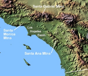
The Santa Ana Mountains are a short peninsular
mountain range along the coast ofSouthern California in theUnited States . They extend for approximately 35 mi (56 km) southeast of theLos Angeles Basin largely along the border between Orange and Riverside counties.Geography
The range starts in the north with the
Chino Hills , heading southeast of thePuente Hills . It s northern section is divided bySanta Ana Canyon , through which theSanta Ana River flows. Its northernmost summit, at convert|3045|ft|m, is Sierra Peak. From there, the major summits are Pleasants Peak, convert|4007|ft|m; Bedford Peak, convert|3800|ft|m; and Bald Peak, convert|3947|ft|m. The next two peaks, Modjeska, convert|5496|ft|m; and Santiago, convert|5687|ft|m, the highest summit in the range; form Saddleback Ridge. The Saddleback, located approximately 20 mi (32 km) east of Santa Ana, is visible from much of Southern California, and is usually the only part of the range high enough to be dusted with snow in winter storms.South of Saddleback are Trabuco Peak, convert|4604|ft|m; Los Pinos Peak, convert|4510|ft|m; Elsinore Peak, convert|3575|ft|m; Sitton Peak, convert|3273|ft|m; and Margarita Peak, convert|3189|ft|m. The range ends roughly at the
Santa Margarita River .Most waterways draining the Santa Anas are ephemeral. The major streams rising from the range typically drain west into the Pacific Ocean, including the
Santa Ana River and its tributarySantiago Creek ,San Diego Creek ,Aliso Creek ,San Juan Creek , San Mateo Creek andSanta Margarita River . Water from the east side of the range empties intoLake Elsinore citeweb | url=http://www.ice.ucdavis.edu/newcara/ | title=California Rivers Assessment Interactive Web Database | work=UC Davis Information Center for the Environment | accessdate=2008-02-21 ] .Much of the range is within the Trabuco Ranger District of the
Cleveland National Forest , although some parts are still owned by two century-old ranches: theIrvine Ranch (Originally known as the Yorba Family's "Rancho Lomas de Santiago") andRancho Mission Viejo (Originally recorded as Rancho "Misión Vieja").The mountains include a subrange called the Elsinore Mountains. These include the mountains which are west of
Lake Elsinore and are the lowest portion of the range. Elsinore Peak marks the highpoint of this area.History
At the time of the first Spanish exploration, the Santa Anas were settled by two main groups of indigenous peoples, the
Tongva in the north, and the Acjachemen and Payomkowishum in the southcitebook | last = McCawley | first = William | title=The First Angelinos: The Gabrielino Indians of Los Angeles | origyear = 1952 | edition = Paperback | year=1996 | publisher=Malki Museum Press/Ballena Press | isbn=0965101606 ] .A handful of historic sites remain in the range today. Registered
California Historical Landmark s include an Indian Village Site inBlack Star Canyon , Flores Peak, the mining boomtown sites of Carbondale and Silverado, and Helena Modjeska's homeciteweb | url=http://ohp.parks.ca.gov/default.asp?page_id=21445 | title= California Historical Landmarks: Orange County | work=California State Parks Office of Historical Preservation website | accessdate=2008-02-21 ] .The last wild
grizzly bear in Santa Ana Mountains was shot and killed in the mountains in 1908. [ [http://www.ocalmanac.com/History/hi01e.htm Orange County - 1889 to 1909 ] ] The mountains are also the site of a famed Indian massacre in 1831 inBlack Star Canyon .Gray Wolf, Pronghorn Antelope, and California Condor also occurred in the range.
Natural Resources
As part of the California Floristic Province, the Santa Ana Mountains host a diverse array of plant species within distinctive natural (plant) communities, including Coastal Sage Scrub, Chaparral, Riparian Woodland, Southern Oak Woodland, Rocky Outcrop, Vernal Pool, Valley Grassland, and Montane Coniferous Forest. One of the southernmost stands of Madrones can be found in Trabuco Canyon. Groves of Knobcone Pine can be found around Pleasants Peak. Big-cone Douglas Fir and Coulter Pine can be found at the higher elevations. Rare flowers like the Intermediate Mariposa Lily, Heart-leaved Pitcher Sage (associated with the Tecate Cypress), and Chocolate Lily are difficult to find, but breathtaking to observe. Fragrant sages, evergreen shrubs and trees, perennial bunchgrasses, strange succulents, and fire-following flowers adorn the rugged terrain.
A surprising variety of wildlife species can be found, including Mountain Lion, Mule Deer, Bobcat, Coyote, Gray Fox, Badger, Ringtail, Spotted Skunk, Western Gray Squirrel, Woodrat, Kangaroo Rat, Bats, Spotted Owl, Western Pond Turtle, Southern Steelhead Trout, Coast Horned Lizard, Least Bell's Vireo, Golden Eagle, Mountain Quail, Canyon Wren, Speckled Rattlesnake, Arroyo Toad, Western Spadefoot Toad, California Treefrog, California Sister Butterfly, Tarantula, and many more.
A number of minerals have been mined in the range, though none were very profitable. Commercial resources collected since the 1870s have included metals lead, silver, tin, and zinc, and minerals clay, coal, gypsum, and limestone. Parts of the range have been used to graze domestic livestock and harvest timber since the late 1700s. As the surrounding cities have grown, the water of the range's creeks has become a particularly valued resourceciteweb | url=http://www.fs.fed.us/r5/cleveland/about/cnfhistory.shtml | title=History of the Cleveland National Forest | work=
Cleveland National Forest website | accessdate=2008-02-21 ] .Transportation
The mountains form a natural barrier between the fast-growing Inland Empire region to the east and the job centers of Orange County to the west. Only one freeway, the
Riverside Freeway (State Route 91), and a narrow and winding mountain highway, State Route 74, connect the regions. Highway 91, which follows the Santa Ana River through a pass between the Santa Ana Mountains on the south and the Chino Hills on the north, is one of California's most congested routes. Because of this, several proposals have been floated to dig a highway tunnel through the Santa Ana Mountains, although the multi-billion-dollar idea has drawn criticism from environmentalists and others concerned about cost and safety in the earthquake-prone region.References
External links
* [http://nature.org/wherewework/northamerica/states/california/preserves/art6334.html The Nature Conservancy: Santa Ana Mountains]
* [http://www.santaanamountains.org Santa Ana Mountains Wild Heritage Project]
* [http://www.naturalist-for-you.org Naturalist For You]
* [http://www.fs.fed.us/r5/cleveland/ Cleveland National Forest]
* [http://www.biologicaldiversity.org/index.html Center For Biological Diversity]
* [http://www.freewebs.com/santaanamountains/index.htm Santa Ana Mountains Natural History Association]
Wikimedia Foundation. 2010.