- California State Route 74
-
State Route 74
Route information Defined by S&HC § 374 Maintained by Caltrans Length: 111.471 mi[2] (179.395 km)
SR 74 is broken into pieces, and the length does not reflect the overlaps that would be required to make the route continuous.Existed: 1934[1] – present Major junctions West end:  I-5 in San Juan Capistrano
 I-15 in Lake Elsinore
 I-215 in Perris
 SR 79 in Hemet
East end:  SR 111 in Palm Desert
Highway system State highways in California(list • pre-1964)
History • Unconstructed • Deleted • Freeway • Scenic←  SR 73
SR 73SR 75  →
→State Route 74 (SR 74), a part of the Pines to Palms Scenic Byway, is a mostly scenic highway in the U.S. state of California. It runs from Palm Desert in Riverside County westward to San Juan Capistrano in Orange County.
Contents
Route description
SR 74 is part of the California Freeway and Expressway System[3] and is eligible for the State Scenic Highway System.[4] However, it is only an eligible scenic highway as designated by Caltrans from the western boundary of the San Bernardino National Forest to its junction with SR 111.[5] State Route 74 is called the California Wildland Firefighters Memorial Highway (from Lake Elsinore to San Juan Capistrano), as designated by various state laws.[6]
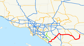
SR 74 begins at an interchange with I-5 in the city of San Juan Capistrano and heads east as Ortega Highway, loosely paralleling San Juan Creek. The highway leaves the San Juan Capistrano city limits and turns northeast, going through the community of Rancho Mission Viejo and entering Ronald W. Caspers Wilderness Park and eventually Cleveland National Forest. After going through San Juan Hot Springs, SR 74 enters Riverside County.[7]
The highway continues winding through the Cleveland Mountains and passes through the community of El Cariso before entering the city of Lake Elsinore. SR 74 continues northwest on Grand Avenue before continuing northeast on Riverside Drive and continuing along the shore of Lake Elsinore. The road continues southeast on Collier Avenue before continuing northeast and intersecting I-15. SR 74 leaves the city of Lake Elsinore and continues through unincorporated Riverside County before turning east and entering Perris. After traveling through downtown, SR 74 merges with I-215 and runs concurrently with I-215 before exiting the freeway as Matthews Road.[8]
SR 74 travels southeast through Romoland and turns east to become Pinacate Road, continuing through Homeland and Green Acres before running concurrently with SR 79 as Florida Avenue through Hemet. SR 79 splits off and heads north towards San Jacinto while SR 74 continues through East Hemet and Valle Vista before entering San Bernardino National Forest. The Pines to Palms Highway parallels San Jacinto Creek as it winds through the mountains before intersecting SR 243 in Mountain Center and providing access to the Hemet Reservoir. SR 74 follows the Garner Valley Wash through Garner Valley before meeting the eastern terminus of SR 371. The road crosses the Santa Rosa Indian Reservation before going through the communities of Gardenland and Pinyon Pines and turning north along Deep Canyon and becoming the western boundary of the University of California Desert Research Area.[8]
As the highway descends to the Palm Springs area, it parallels Carrizo Creek before entering the city limits of Palm Desert, where SR 74 meets its current legal northern terminus. The SR 74 designation continued into Palm Desert as a city arterial to its northern terminus at SR 111, which has also had its designation removed through Palm Desert.[8]
Route 74 passes through many parks and National Forests along its route. Some of these places include the San Bernardino National Forest, the Cleveland National Forest, the Ronald W. Caspers Wilderness Park, Lake Elsinore State Recreation Park, the Soboba Indian Reservation, Lake Hemet and the Santa Rosa Indian Reservation.
History
The route has been signed as Route 74 since the establishment of state routes in 1934.[1] Its original corridor between then CA 71 Corona Freeway(later I-15W) and present-day I-215(then ,I-15E and U.S.395) was numbered as U.S.395 , through downtown Perris. East of the CA 74 / U.S.395 junction , from Romoland-east , was CA 740 (Florida Avenue).
A portion of Route 74 in Orange and Riverside counties is named after the famous Spanish explorer Sgt. Jose Ortega, who led a small party of men around the newly discovered San Francisco Bay from Palo Alto to the Carquinez Straits.[9]
A portion of Route 74 appears in the 1963 American comedy film "It's A Mad, Mad, Mad, Mad World" during the opening act where the film's major characters meet for the first time.[10]
Major intersections
- Note: Except where prefixed with a letter, postmiles were measured in 1964, based on the alignment as it existed at that time, and do not necessarily reflect current mileage. The numbers reset at county lines; the start and end postmiles in each county are given in the county column.
County Location Postmile
[2][11][12]Destinations Notes Orange
ORA 0.00-15.60San Juan Capistrano 0.00 Ortega Highway (to Camino Capistrano) Continuation beyond I-5 0.00 I-5 (San Diego Freeway) – Los Angeles, San DiegoInterchange Antonio Parkway, La Pata Avenue – Ladera Ranch La Pata Avenue serves San Juan Hills High School Riverside
RIV 0.00-96.01Lake Elsinore 11.83 Grand Avenue – Lakeland Village 17.24 I-15 (Temecula Valley Freeway) – Corona, San DiegoInterchange Perris 27.53
26.31[N 1] I-215 north (Escondido Freeway) / Redlands Avenue – RiversideInterchange; west end of I-215 overlap; former I-15E north / US 395 north West end of freeway on I-215 East end of freeway on I-215 23.54[N 1]
27.54 I-215 south (Escondido Freeway) – San DiegoInterchange; east end of I-215 overlap; former I-15E south / US 395 south Homeland Juniper Flats Road Hemet 34.33 SR 79 south (Winchester Road) / Vista Place – Winchester, San DiegoWest end of SR 79 overlap 36.92 Warren Road Serves Hemet-Ryan Airport 41.34 SR 79 north (San Jacinto Road) – San JacintoEast end of SR 79 overlap Ramona Expressway 44.74 Mountain Avenue – San Jacinto Reservoir Mountain Center 59.25  SR 243 – Idyllwild, Banning
Lake Hemet (Hemet Lake Road) 71.75  SR 371 – Anza, San Diego
Palm Desert 96.01 SR 111 – Palm Springs, Indio96.01 Monterey Avenue Continuation beyond SR 111 1.000 mi = 1.609 km; 1.000 km = 0.621 mi
Concurrency terminus • Closed/Former • Incomplete access • UnopenedReferences
- ^ a b California Highways: State Route 74
- ^ a b California Department of Transportation, State Truck Route List (XLS file), accessed February 2008
- ^ CA Codes (shc:250-257)
- ^ CA Codes (shc:260-284)
- ^ California Department of Transportation, Officially Designated Scenic Highways, accessed 2010-03-20
- ^ (PDF) 2007 Named Freeways, Highways, Structures and Other Appurtenances in California. Caltrans. pp. 133–134. http://www.dot.ca.gov/hq/tsip/hseb/products/Named_Freeways.pdf. Retrieved 2007-03-28.
- ^ Thomas Brothers (2008). Orange County Road Atlas (Map).
- ^ a b c Thomas Brothers (2008). Riverside County Road Atlas (Map).
- ^ 2008 Named Freeways, Highways, Structures and Other Appurtenances in California", a publication prepared by the State of California Business, Transportation and Housing Agency, Department of Transportation
- ^ Wikipedia: It's A Mad, Mad, Mad, Mad World, 1963 American Comedy Film
- ^ California Department of Transportation, Log of Bridges on State Highways, July 2007
- ^ California Department of Transportation, All Traffic Volumes on CSHS, 2005 and 2006
Categories:- State highways in California
- Juan Bautista de Anza National Historic Trail
- Roads in Orange County, California
- Roads in Riverside County, California
- Scenic highways in California


Wikimedia Foundation. 2010.