- San Bernardino Mountains
Geobox|Range
name=San Bernardino Mountains

image_caption=Mt. San Gorgonio with Big Bear Lake in the background.
country=United States
state=California
region_type = County
region=San Bernardino
region1=
border=San Gabriel Mountains| border1=San Jacinto Mountains
highest=San Gorgonio Mountain
highest_elevation_imperial=11499
highest_lat_d=34|highest_lat_m=5|highest_lat_s=0
highest_long_d=116|highest_long_m=49|highest_long_s=0
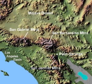
The San Bernardino Mountains (Huwaaly Kwasakyav [Munro, P et al. "A Mojave Dictionary" Los Angeles: UCLA, 1992] in Mojave) are a short transverse
mountain range northeast of Los Angeles in SouthernCalifornia in theUnited States . The mountains are also located north and east ofSan Bernardino, California (the nearest big city).The mountains run for approximately 60 mi (100 km) east-west on the southern edge of theMojave Desert in southwestern San Bernardino County, north of the city of San Bernardino. The range is separated from theSan Gabriel Mountains to the west byCajon Pass , and from theSan Jacinto Mountains to the south/southeast byBanning Pass . The southern extent of the range is bounded by theSan Andreas Fault .The highest peaks in the range include
San Gorgonio Mountain (elevation 11,499 ft/3,505 m), the highest peak in southern California, and other peaks of the San Gorgonio Wilderness. The shorterLittle San Bernardino Mountains extend southeast from the range along the eastern side of theCoachella Valley .Most of the range is located within the
San Bernardino National Forest . TheSan Gorgonio Wilderness is located in the southeast corner of the range. The mountain range is also the location of four popular recreational destinations in the Inland Empire area: Crestline, Lake Arrowhead, Running Springs and Big Bear Lake.ignificant peaks
These are the highest peaks of the San Bernardino Mountains, sorted by elevation from highest to lowest.
*
San Gorgonio Mountain Convert| 11499|ft|m | 0|abbr=on
*Jepson Peak Convert| 11205|ft|m | 0|abbr=on
*Bighorn Mountain Convert| 10997|ft|m | 0|abbr=on
*Dragons Head Convert| 10866|ft|m | 0|abbr=on
* Anderson Peak Convert| 10840|ft|m | 0|abbr=on
*Charlton Peak Convert| 10806|ft|m | 0|abbr=on
*Shields Peak Convert| 10680|ft|m | 0|abbr=on
*San Bernardino Peak Convert| 10649|ft|m | 0|abbr=on
*Little Dobbs Peak Convert| 10520|ft|m | 0|abbr=on
*Dobbs Peak Convert| 10459|ft|m | 0|abbr=onBodies of water & water ways
Lakes
* Lake Gregory
*Big Bear Lake
*Lake Silverwood
*Lake Arrowhead
*Jenks Lake
*Green Valley Lake
*Dry Lake South Fork Trail
*Dollar Lake South Fork Trail Water ways
*
Santa Ana River
* Mill Creek
*Mojave River
*Deep Creek
* Whitewater River
*San Gorgonio River ee also
Nearby mountain ranges:
*Little San Bernardino Mountains (east)
*San Jacinto Mountains (south acrossSan Gorgonio Pass )
*San Gabriel Mountains (west acrossCajon Pass )References
* [http://www.peakbagger.com/range.aspx?rid=12317 Peakbagger.com San Bernardino Mountains peak list]
Wikimedia Foundation. 2010.