- Channel Islands of California
-
Channel Islands of California 

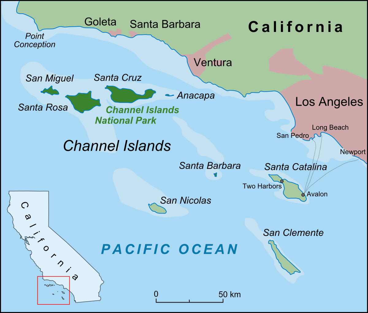
Geography Location Pacific Ocean Total islands 8 Area 350.89 sq mi (908.8 km2) Highest elevation 2,450 ft (747 m) Highest point Devils Peak, Santa Cruz Island Country United StatesState  California
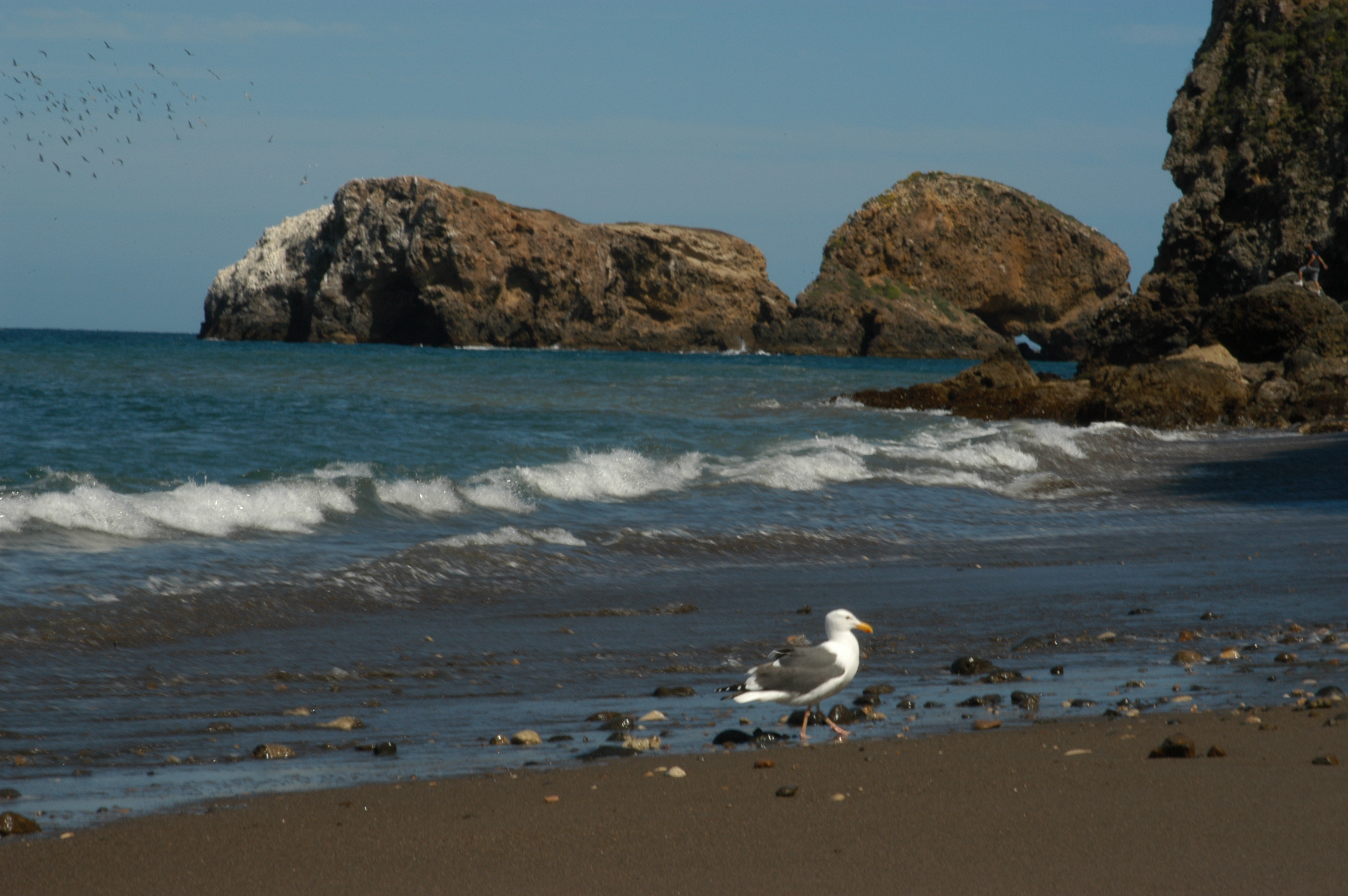
Largest city Avalon (pop. 3127) Demographics Population 3703 (as of 2000)  Beach of Santa Cruz Island
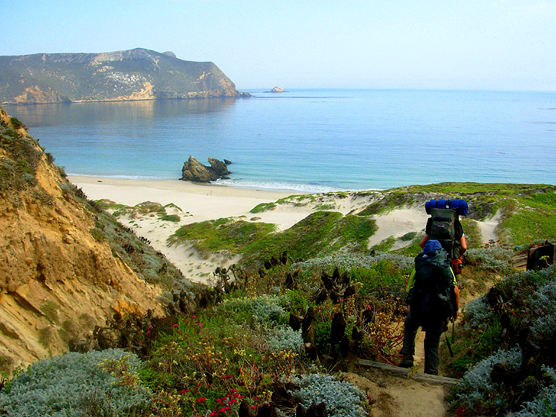
 Beach at San Miguel
The Channel Islands of California are a chain of eight islands located in the Pacific Ocean off the coast of Southern California along the Santa Barbara Channel in the United States of America. Five of the islands are part of the Channel Islands National Park.
Contents
Characteristics
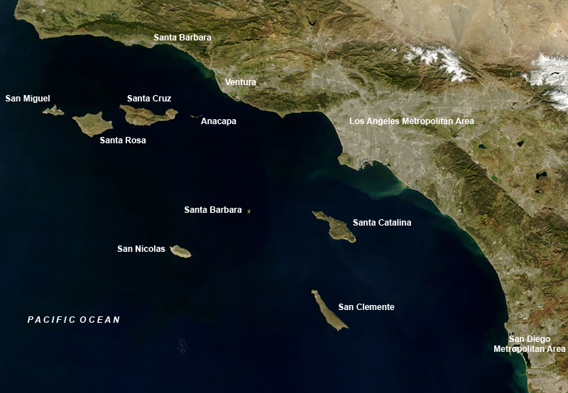
The eight islands are split among the jurisdictions of three separate California counties: Santa Barbara County (four), Ventura County (two) and Los Angeles County (two). The islands are divided into two groups — the Northern Channel Islands and the Southern Channel Islands. The four Northern Islands used to be a single landmass known as Santa Rosae.
The archipelago extends for 160 miles (257.51 kilometers) between San Miguel Island in the north and San Clemente Island in the south. Together, the islands’ land area totals 221,331 acres (89,569 ha), or about 346 square miles (900 km2).
Five of the islands (San Miguel, Santa Rosa, Santa Cruz, Anacapa, and Santa Barbara) were made into the Channel Islands National Park in 1980. The Channel Islands National Marine Sanctuary encompasses the waters six nautical miles (11 kilometers) off Anacapa, Santa Cruz, San Miguel and Santa Barbara islands.
Santa Catalina Island is the only one of the eight islands with a significant permanent civilian settlement—the resort city of Avalon, California, and the unincorporated town of Two Harbors.
Natural seepage of oil occurs at several places in the Santa Barbara Channel.[1] Tar balls or pieces of tar in small numbers are found in the kelp and on the beaches. Native Americans used naturally occurring tar, bitumen, for a variety of purposes which include roofing, waterproofing, paving and some ceremonial purposes.[2]
The Channel Islands at low elevations are virtually frost-free and constitute one of the few such areas in the 48 contiguous US states. It snows only rarely, on higher mountain peaks.
The eight Channel Islands of California, off the west coast of North America
Island Area
mi²Area
km²Population
Census 2000County Highest peak
feet (m)Northern islands Anacapa 1.14 2.95 3 Ventura Summit Peak, 930 (283) San Miguel 14.57 37.74 - Santa Barbara San Miguel Hill, 831 (253) Santa Cruz 96.51 249.95 2 Santa Barbara Devils Peak, 2450+ (747+) Santa Rosa 83.12 215.27 2 Santa Barbara Soledad Peak, 1589 (484) Southern islands San Clemente 56.81 147.13 3001) Los Angeles Vista Point, 1965 (599) San Nicolas 22.75 58.93 2001) Ventura unnamed, 907 (276) Santa Barbara 1.02 2.63 - Santa Barbara Signal Hill, 634 (193) Santa Catalina 74.98 194.19 3696 Los Angeles Mount Orizaba, 2123 (648) Channel Islands 350.89 908.79 3703 Devils Peak, 2450+ (747+) 1) Navy installations, itinerant military and civilian population History
Separated from the California mainland throughout recent geological history, the Channel Islands provide the earliest evidence for human seafaring in the Americas. It is also the site of the discovery of the earliest paleontological evidence of humans in North America.[3] The Northern Channel Islands are now known to have been settled by maritime Paleo Indian peoples at least 13,000 years ago. Archaeological sites on the island provide a unique and invaluable record of human interaction with Channel Island marine and terrestrial ecosystems from the late Pleistocene to historic times. Historically, the northern islands were occupied by the Island Chumash, while the southern islands were occupied by the Tongva. The Chumash and Tongva were removed from the islands in the early 19th century, taken to Spanish missions and pueblos on the adjacent mainland. For a century, the Channel Islands were used primarily for ranching and fishing activities, which had significant impacts on island ecosystems, including the local extinction of sea otters, bald eagles, and other species. With most of the Channel Islands now managed by federal agencies or conservation groups, the restoration of the island ecosystems has made significant progress.
In 1972, the Brown Berets, a group of Chicano activists, seized and claimed the islands for Mexico, citing the Treaty of Guadalupe Hidalgo, a treaty between Mexico and the USA by which Mexico lost more than half of its territory, and arguing that the treaty does not specifically mention the Channel Islands nor the Farallon Islands. Though the United States had occupied them since 1852, the group speculated that Mexico could claim the islands and seek their return through litigation before the International Court of Justice. However, a detailed analysis of its situation puts in doubt the likelihood of Mexico winning the case at the International Court of Justice.[4]
Military use
The United States Navy completely controls San Nicolas Island and San Clemente Island and has installations elsewhere in the chain. During World War II all of Southern California’s Channel Islands were put under complete military control—including the civilian-populated Santa Catalina where tourism was halted and established residents needed permits to travel to and from the mainland.[5] San Miguel Island was used as a bombing range[6] and Santa Barbara Island as an early warning outpost under the presumed threat of a Japanese attack on California.[7]
Wildlife
Main article: Notable wildlife of the California Channel IslandsThe Channel Islands are part of one of the richest marine biospheres of the world. Many unique species of plants and animals are endemic to the Channel Islands, including fauna such as the Island Fox, Channel Islands Spotted Skunk, Island Scrub Jay, Ashy Storm-petrel, Island fence lizard, Island Night Lizard, Channel Island Slender Salamander, San Clemente Goat, Santa Cruz sheep, San Clemente loggerhead shrike, San Clemente sage sparrow and flora including a unique subspecies of Torrey Pine[8] and Oak and the Island Tree mallow.
-

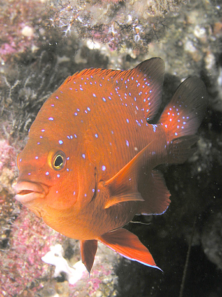
Garibaldi, Catalina Island
-

Juvenile Garibaldi, Catalina Island
-
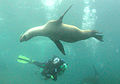
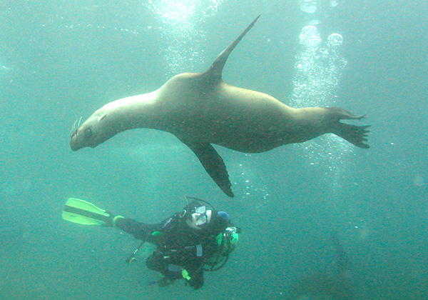
Diver and juvenile Sea Lion, Anacapa Island
-

Kelp forest and sardines
-

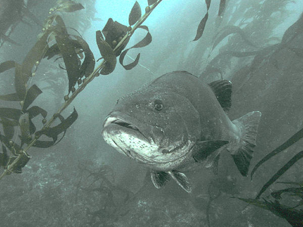
Giant Black Sea Bass, San Clemente Island
-
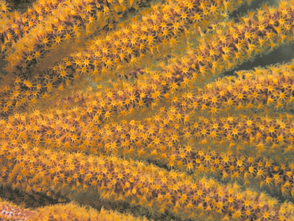
Sea Fan, Anacapa Island
-

Hermissenda Crassigoyis, San Clemente Island
-

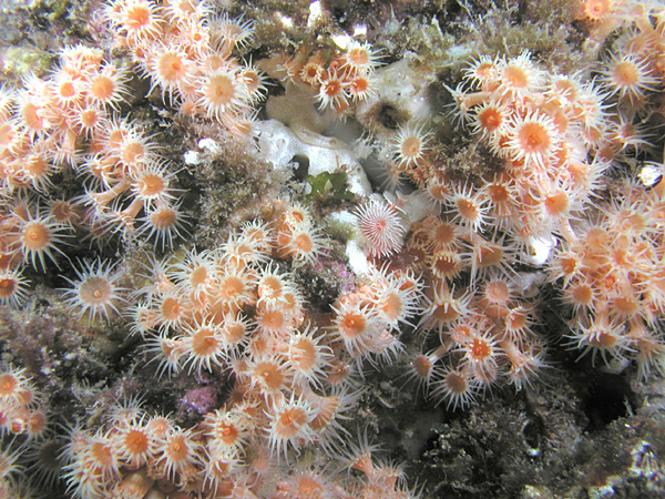
Anemones, Catalina Island
-
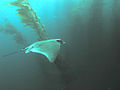
Bat Ray in kelp forest, San Clemente Island
See also
- Guadalupe Island and the Coronado Islands of Baja California, Mexico share the California chaparral and woodlands ecoregion with the Channel Islands
- Channel Islands (similarly named islands in the English Channel, off the coast of France)
- Dwarf elephant on Channel Islands
- List of islands of California
Notes
- ^ "Shallow seepage impacting the Santa Barbara Channel Islands, Santa Cruz, Santa Rosa and San Miguel". http://www.sciencedirect.com/science?_ob=ArticleURL&_udi=B6V7P-4C47JKF-3&_user=2792286&_coverDate=06%2F30%2F2004&_rdoc=1&_fmt=full&_orig=gateway&_origin=gateway&_cdi=5848&_sort=d&_docanchor=&view=c&_searchStrId=1726915615&_rerunOrigin=google&_acct=C000058814&_version=1&_urlVersion=0&_userid=2792286&md5=cf36e5c6c3b8ac1bc1f7323d9972e537&searchtype=a&artImgPref=F.
- ^ "Natural Oil and Gas Seepage in the Coastal Areas of California" (pdf). http://www.boemre.gov/omm/pacific/public/Library-PDFs/Natural-Oil-Gas-Seepage.pdf.
- ^ "Journey to 10,000 B.C". History Channel. Aired 4 May 2008.
- ^ Barnard R. Thompson. "Mexico’s Claim to California Islands – A Never-ending Story". http://mexidata.info/id1596.html.
- ^ "Catalina Island During WWII". http://www.ecatalina.com/article_ww2.cfm. Retrieved 2008-03-08.
- ^ "San Miguel Island (9,325 acres)". http://www.channel.islands.national-park.com/info.htm#migu. Retrieved 2008-03-08.
- ^ "Santa Barbara Island (639 acres)". http://www.channel.islands.national-park.com/info.htm#barb. Retrieved 2008-03-08.
- ^ C. Michael Hogan. 2008. Torrey Pine: Pinus torreyana, Globaltwitcher, ed. Nicklas Stromberg [1]
External links
- Anacapa Island Site with Photos and History
- Channel Islands National Park
- Channel Islands National Marine Sanctuary
- Catalina Island Life During WWII
- "Military Wants Santa Rosa Island" LA Times 12/10/05
- "The Channel Islands: Special Places in the Garden's History," Santa Barbara Botanic Garden Newsletter: Part 2 | Part 3 | Part 4 | Part 5 (Part 1 not online)
- A review in the NY Times, Feb 2011, by Barbara Kingsolver, of T. C. Boyle's comic novel about the Channel Islands, "When the Killing's Done." http://www.nytimes.com/2011/02/20/books/review/Kingsolver-t.html?ref=review
Coordinates: 34°00′58″N 119°48′14″W / 34.01611°N 119.80389°W
Channel Islands of California 
 State of California
Topics - Climate
- Delegations
- Deserts
- Districts
- Ecology
- Elections
- Environment
- Geography
- Government
- History
- Protected areas
- Sports
- Symbols
- Transportation
- Visitor attractions
- Index of California-related articles
Society Regions - Antelope Valley
- Big Sur
- Cascade Range
- Central California
- Central Coast
- Central Valley
- Channel Islands
- Coachella Valley
- Conejo Valley
- Cucamonga Valley
- Death Valley
- East Bay (SF)
- East County (SD)
- Eastern California
- Emerald Triangle
- Gold Country
- Great Basin
- Greater Los Angeles
- Greater Sacramento
- Inland Empire
- Lake Tahoe
- Los Angeles Basin
- Lost Coast
- Metropolitan Fresno
- Mojave
- Mountain Empire
- North Bay (SF)
- North Coast
- North County (SD)
- Northern California
- Owens Valley
- Oxnard Plain
- San Francisco Peninsula
- Pomona Valley
- Sacramento Valley
- San Bernardino Valley
- San Diego–Tijuana
- San Fernando Valley
- San Francisco Bay Area
- San Gabriel Valley
- San Joaquin Valley
- Santa Clara Valley
- Santa Clara River Valley
- Santa Clarita Valley
- Shasta Cascade
- Sierra Nevada
- Silicon Valley
- South Bay (LA)
- South Bay (SF)
- South Bay (SD)
- South Coast
- Southern California
- Southern Border Region
- Tri-Valley
- Upstate California
- Victor Valley
- Wine Country
- Yosemite
Metro areas - Bakersfield
- Chico
- El Centro
- Fresno
- Hanford–Corcoran
- Los Angeles–Long Beach–Glendale
- Madera
- Modesto
- Merced
- Napa
- Oakland–Fremont–Hayward
- Oxnard–Thousand Oaks–Ventura
- Redding
- Riverside–San Bernardino–Ontario
- Sacramento–Arden Arcade–Roseville
- Salinas
- San Diego–Carlsbad–San Marcos
- San Francisco–San Mateo–Redwood City
- San Jose–Sunnyvale–Santa Clara
- San Luis Obispo–Paso Robles
- Santa Ana–Anaheim–Irvine
- Santa Barbara–Santa Maria–Goleta
- Santa Cruz–Watsonville
- Santa Rosa–Petaluma
- Stockton
- Vallejo–Fairfield
- Visalia–Porterville
- Yuba City
Micro areas Counties - Alameda
- Alpine
- Amador
- Butte
- Calaveras
- Colusa
- Contra Costa
- Del Norte
- El Dorado
- Fresno
- Glenn
- Humboldt
- Imperial
- Inyo
- Kern
- Kings
- Lake
- Lassen
- Los Angeles
- Madera
- Marin
- Mariposa
- Mendocino
- Merced
- Modoc
- Mono
- Monterey
- Napa
- Nevada
- Orange
- Placer
- Plumas
- Riverside
- Sacramento
- San Benito
- San Bernardino
- San Diego
- San Francisco
- San Joaquin
- San Luis Obispo
- San Mateo
- Santa Barbara
- Santa Clara
- Santa Cruz
- Shasta
- Sierra
- Siskiyou
- Solano
- Sonoma
- Stanislaus
- Sutter
- Tehama
- Trinity
- Tulare
- Tuolumne
- Ventura
- Yolo
- Yuba
Categories:- Channel Islands of California
- Islands of California
-


Wikimedia Foundation. 2010.